

bristolri_wx
-
Posts
1,477 -
Joined
-
Last visited
Content Type
Profiles
Blogs
Forums
American Weather
Media Demo
Store
Gallery
Posts posted by bristolri_wx
-
-
You all should be disappointed. Last years panic room opened on December 2.
What a bunch of lame weenies letting 26 days of winter passing before starting to panic. What has happened to this forum???
-
 1
1
-
 4
4
-
-
1 hour ago, CoastalWx said:
If we only lived at 10mb.

-
2
-
5
-
-
1 minute ago, CoastalWx said:
Yeah that article is not correct.
Yeah I was scratching my head reading that and wondering if I was confused, lol…
-
May not look like Christmas, but it damn sure feels like it outside. Merry Christmas everyone!!


-
2
-
-
Winds noticeably picking up here. Not a fan of this particular output for the morning...
-
1
-
-
26 minutes ago, Whineminster said:
BOX really doesn't seem to be hitting this thing that hard in their AFD, kinda poo pooing it.
QuoteThe main concern tonight into Friday will be the wind. These low pressures are continuing to strengthen, generating a low level jet of 60-80 kt at 925 mb. The core of this jet is focused mainly across the eastern half of southern New England, where High Wind Warnings continue. Farther west, Wind Advisories are in effect, including Worcester and NW MIddlesex counties, which were previously in a watch. Just not confident these areas will be able to tap into the stronger jet, despite the higher elevation.
-
1 hour ago, dendrite said:
Maybe a little for the west slopes, but keep in mind that isn't all instantaneous. That's thickness paired with 6hr averaged precip. So a lot of that precip is outta here before the column cools to support snow.
I would defer to the hi-res models to see if a snow squall line actually makes it through. Earlier this morning, only the RGEM showed it, all the US hi-res models (NAM 3K, HRRR, FV3) showed a squall line that was rain-only except for the highest elevations up north.
-
We are 67 pages in for a storm with not much (if any) snow for us but from a purely interesting weather perspective this has been an entertaining one to track and discuss. Maybe we get a Christmas miracle inch on the back side as that hell of a cold front comes through. Not often that Arctic air moves into our area from the southwest so there might still be some surprises at the end of this storm. High gusts still on the table in the coastal plain as well. Stay tuned!!
-
2
-
-
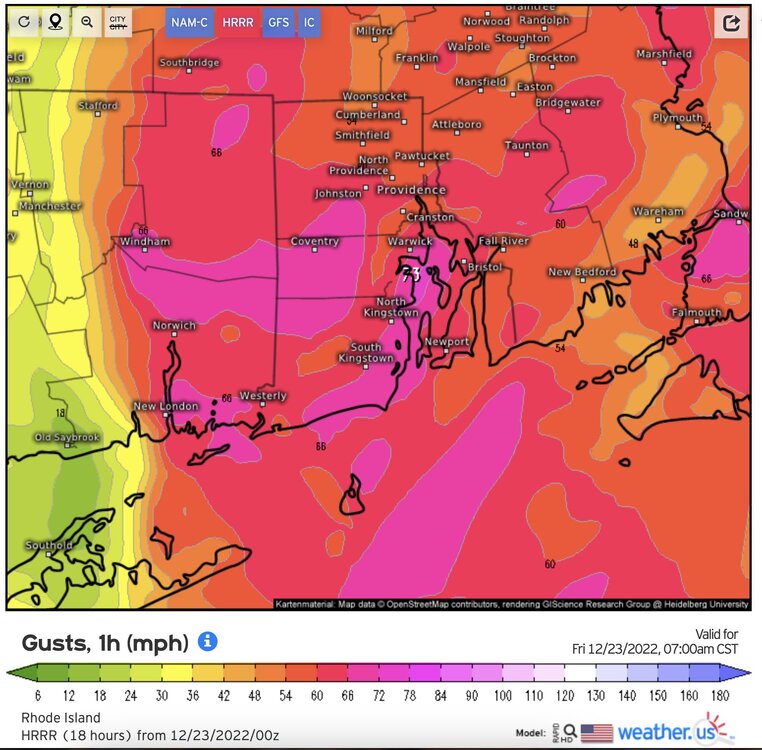
Wow, those 925mb maps on Pivotal look a little crazy. No guarantee that 925 winds mix down to the surface, but I'm looking at almost 36 hrs of 50kt+ winds at my location so lots of opportunities for high gusts.
EDIT: The wind gust maps on weather.us are not encouraging either. What a mess...
-
1
-
-
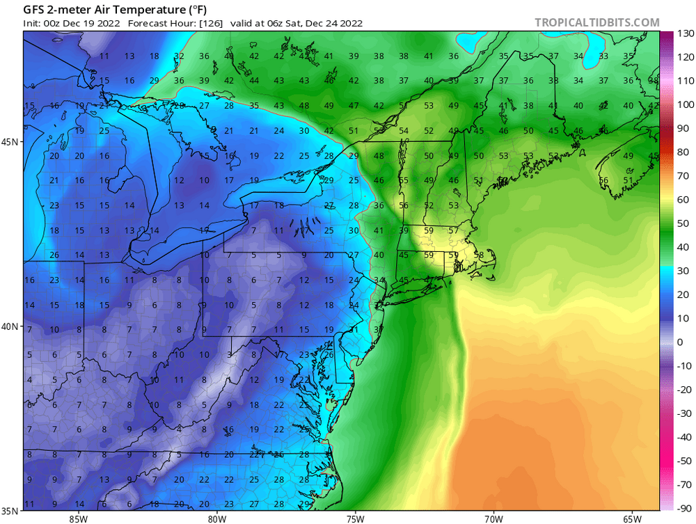
20 minutes ago, MJO812 said:
.thumb.png.3f510327d3d151b94d31f10c82515021.png)
Look at the temps at the same frame. 10 degrees in Nashville while it's 60 in Providence. Still not to far away from a solution where we might get an inch or two as the front comes through. Just need that squall line to hold up. Christmas Eve and Christmas Day look COLD.
-
1
-
-
1 hour ago, mreaves said:
That Pats loss. Wow.
First time in weeks I had some time to watch the Pats - caught last five minutes. Terrible.
-
22 minutes ago, CoastalWx said:
Looks like the cutter on the euro is ingesting a TS off the southeast coast later this week lol.
That little tropical low has been there last few runs lol…
-
1
-
-
46 minutes ago, moneypitmike said:
Thanks.
I vote for moderators deleting any storm threads that are more than 3 days out--let alone 8 (!!!). That's what the discussion thread is for. Otherwise the two threads become conflated.
I dunno, not sure what the problem is. We are still going to be getting impactful weather from a powerful storm during the timeframe mentioned. Just not a big snow storm for most. This thread served a purpose, discussion of one developing storm.
-
11 minutes ago, TauntonBlizzard2013 said:
That’s a lot. OEM tires kind of seem like garbage. My wife’s had to be replaced early as well, and the next set has been going strong
OEM tires are usually garbage. Treadlife is usually 45k to get them through a three year lease.
I highly recommend these:
https://www.michelinman.com/auto/tires/michelin-defender-ltx-m-s
Have these on my CR-V and RAV4. Good all season tire especially for winter and long tread life as long as you rotate regularly.
-
1 hour ago, TauntonBlizzard2013 said:
Is this dangerous? I have absolutely no idea how long it’s been like this? Given the rim look below, it looks weathered, so possibly a while

Yeah that could blow at some point. More likely at high speeds or in warmer weather. You should replace that tire ASAP IMO for you and your vehicles safety.
-
Sorry, call me an optimist but this is all I can think in my head after reading this forum the last few days:
Maybe Winter 22-23 will turn out to be a turd, but we have had several good to great winters that started with shitty Decembers and grinch storms right before Christmas. Can’t give up on things less than a third of the way through.
-
1
-
-
11 minutes ago, 40/70 Benchmark said:
The kids have no more Xmas gifts left, so you're up, slugger..
15 minutes ago, 40/70 Benchmark said:The kids have no more Xmas gifts left, so you're up, slugger..

-
Just now, Snowcrazed71 said:
It's one truly is a done deal. It's not coming back in any way shape or form. Now for separate storm followed on its heels by some odd chance, that would be a different story. But this particular storm. It is absolutely 100% not for the Northeast
It’s a volatile pattern for the model accuracy in the medium to long range. Things don’t look good but I wouldn’t give up for another 48 hours or so if your hope is for a colder snowier outcomes.
-
Down in the coastal plain
It was always forecasted as rain
So there was no pain
When the snow
Did not show.
-
3
-
-
13 minutes ago, Torch Tiger said:
Hopefully it's a very strong storm and hugger track, so NNE gets crushed even if they mix some.

-
1
-
-
3 hours ago, MRVexpat said:
Thanks! Interesting but I was more curious to its anecdotal accuracy/usefulness as a high res model.
Personally I look at it on TT and Pivotal, but I don’t think it has a lot of weight on its own. I believe the biggest use case for many of the WRF based models are being part of the SREF and HREF ensemble forecast packages. I’m sure there are mets here who have more facts to back that up than I do.
-
1
-
-
20 minutes ago, MRVexpat said:
Also WTF is a HRW WRF-ARW and does anyone care about it?
-
Are people still pissed about the recent GFS upgrade?
-
1
-
-
Bing Crosby has entered that chat.
-
1
-

.png.634ba5f7bac81e538f0063d61d8caef5.png)

January 2023 Obs/Discussion
in New England
Posted
Personally, it's nice to have it cold around the holidays, even if it isn't snowy. However, once New Year's passes, as much as I enjoy the interesting weather, if it's torching so-be-it. I'm sure I'm in the minority...