Winter Wizard
-
Posts
689 -
Joined
-
Last visited
Content Type
Profiles
Blogs
Forums
American Weather
Media Demo
Store
Gallery
Everything posted by Winter Wizard
-
Just wait until you see the reports coming out the eastern Shore and Sussex County, DE
-
1.3” looks like the final total in Annapolis and you can hear the drip, drip, drip outside melting it away. Such is life when you live close to the Bay.
-

Jan 31st - 33rd Storm Obs and Disco like it's 1979
Winter Wizard replied to Bob Chill's topic in Mid Atlantic
Annapolis sleeting -
Jan 31st - 33rd Storm Obs and Disco like it's 1979
Winter Wizard replied to Bob Chill's topic in Mid Atlantic
Pushing 2” in Annapolis with a nice band coming in. -
Jan 31st - 33rd Storm Obs and Disco like it's 1979
Winter Wizard replied to Bob Chill's topic in Mid Atlantic
I’m in Annapolis and generally the farther north and east you are, the better banding you’ll see. Being against the Bay also keeps us a bit warmer though due to the marine layer so we may mix for longer. -
Jan 31st - 33rd Storm Obs and Disco like it's 1979
Winter Wizard replied to Bob Chill's topic in Mid Atlantic
Stronger ridge would lead to a more amplified ULL and probably would support the more tucked in solutions. But again, this is purely anecdotal for now. -
Jan 31st - 33rd Storm Obs and Disco like it's 1979
Winter Wizard replied to Bob Chill's topic in Mid Atlantic
850 mb winds on the NAM are ripping southeast at over 40 knots 0z Monday which torches the mid-levels I-95 south and east. This is significantly higher than any other guidance has and the SLP track is also farther west. Also, checking out the obs: this is anecdotal, but could support a deeper ULL: -
Jan 25th Wintry Mix Obs and Nowcasting
Winter Wizard replied to stormtracker's topic in Mid Atlantic
All snow in Annapolis -
I think this is just a matter of perception - keep in mind that a negative bust for you usually means a positive bust for someone else. Additionally, there is still a margin of error even in short range, and slight adjustments to a storm's track have significant implications. The January 2015 bust in NYC is a great example of this, same with Boxing Day 2010 for our area. If we think about recent storms like March 2017 and the one this week, it could be that NWP models underestimate mid-level warmth, as evidenced by the sleet line going farther north and west than expected. This storm is also another example of how deceiving snow maps can be in marginal setups, as many of them count sleet as snow and that inflates totals.
-
January 2000 is the ultimate example of a positive bust in our area. The storm was predicted to go out to sea but instead continued northward and dumped over a foot of snow across much of the area. As @MillvilleWx alluded to, NWP models have substantially increased in accuracy since then, so such a large-scale bust likely won't happen again. November 1987 I imagine was a similar type of positive bust. November 2018 is also a good recent example: the storm ended up colder than expected, so areas along I-95 and north and west got quite a bit more than forecast. December 2013 is a different case since that was the result of a mesoscale band in an area of strong convergence. - those types of busts can still happen as models have still have difficulty pinpointing the magnitude and location of those bands. Just ask Binghamton, for example. In February 2009, there was an inverted trough that set up near Philly and dropped a surprise 8 inches over the city.
-
Central PA - Winter 2020/2021
Winter Wizard replied to MAG5035's topic in Upstate New York/Pennsylvania
Had to make the trip back to Happy Valley for this storm! Looks like for the first time in a long time, this entire subforum will be the jackpot zone, hope you all enjoy. -
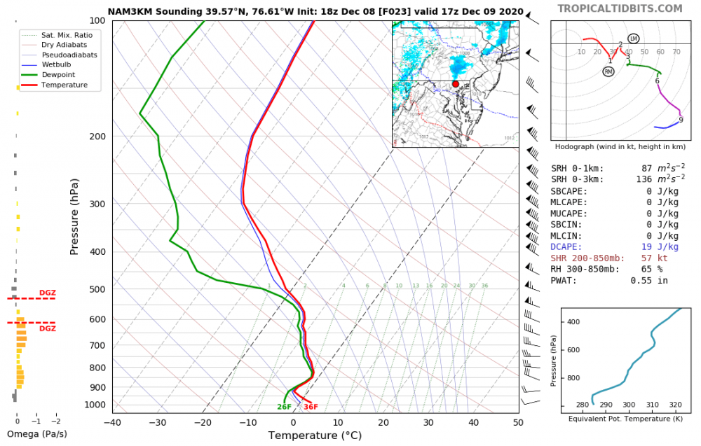
I'm not sure I'd put it as far south as you, aka I-70, but verbatim the NAM soundings are saturated in the low-to-mid levels and have decent vertical velocities. Best chances of seeing a snow shower is north of the Mason-Dixon line, but I could see there being enough uncertainty to drop it south a little.
-
Didn’t see it mentioned but at 0z the NAM went back north and is in line with other guidance. No flakes until you get to I-80.
-
Worst 11-0 team ever
-
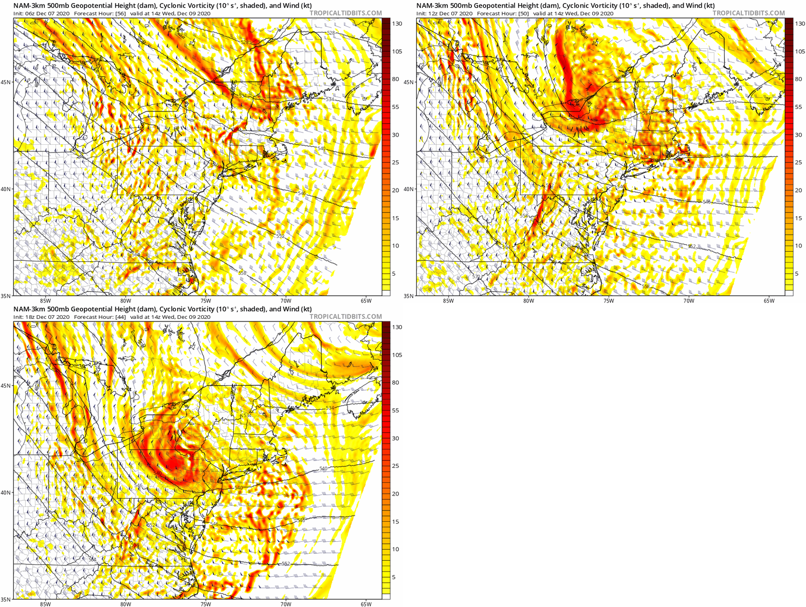
Well this is a somewhat interesting trend from the 3km NAM for Wednesday morning snow showers in the northern half of the subforum. Forecast soundings appear to be fairly moist from the surface to the mid-levels with temperatures close to freezing.
-
Interesting read. I can't find it at the moment, but I believe HM tweeted earlier in the Fall about how smoke plumes tend to increase the stratospheric temperature gradient, and that, in turn, would lead to a stronger PV and +NAM state. The lack of heat flux in the polar stratosphere that has been observed this season would also likely contribute to that, although not sure of/if there's a relation between that and aerosols from the western US fires.
-
Reconsider majoring in meteorology!
Winter Wizard replied to stormguy80's topic in Weather Forecasting and Discussion
It's definitely important to consider, I'd argue all applicants should ask companies what they did to accommodate employees during COVID. Those that haven't done much to keep employees safe probably aren't enjoyable to work for. -
Reconsider majoring in meteorology!
Winter Wizard replied to stormguy80's topic in Weather Forecasting and Discussion
I know this is an old thread (and unfortunately not a ton has changed over the past decade), but my two cents is if you're going to get a degree in Meteorology, it is important to supplement it with another marketable skill. Those include programming, GIS, business/finance, etc. depending on the path you choose. There is a lot of talk about how bad starting salaries are in this field and yes, there is a lot of truth to that, but you can do well if you look into the right places and are willing to expand your horizons. If you want to go on TV, you are looking at salaries in the 20s or low 30s to start and will likely have to move to a small town in a different part of the country. There are opportunities to move up, but those jobs are highly competitive, so you will really have to hustle. Ultimately, due to low wages and station politics, many end up leaving this sector after a few years. If you end up in broadcast, I would recommend not getting fixated on market size; rather, focus on where you can get the most on-air experience. That will help you eventually move up. The next main sector is operational forecasting and I'm bearish about long-term prospects here. Salaries are about the same or slightly higher than broadcast, but in many cases barely a livable wage and laughable for the work put in for the degree. You will be required to work overnights and weekends at most companies and this can take a major physical and mental toll. Not much upward mobility. NWS is a similar deal, however, the pay and benefits are much better and increase over time. To get in, you will likely need a couple years of experience in a private sector job or a Master's. Additionally, with automation becoming more and more prevalent, the demand for a large team of human forecasters is likely to decline, although there will still be a need. Overall, operational forecasting is a good way to get into the industry, but probably best to leave after a couple years. What has changed in the past 10 years is the emergence of the Weather Risk sector. This is a program only offered at a few schools; Penn State pioneered the program and others have recently added it. Weather risk involves sectors including catastrophe modeling, travel risk management, energy and commodities, insurance, reinsurance, etc. In these sectors, the salaries are much higher (can easily pull six figures) and demand will continue to increase as businesses are forced to adapt to climate change. Overall, if you are planning on getting a degree in Meteorology, this is definitely the most fruitful path, BUT it is highly competitive. Long story short, I would say reconsider majoring in Meteorology if it forces you into tens of thousands of dollars into student debt and you end up in a sector with little-to-no upward mobility. The Math, Physics, Chem, Programming, Stats, and Business (in weather risk) classes you are required to take gives you a variety of skills that can easily be applied to other fields outside of Meteorology. If you do go through with the major, please consider the various sectors above and do what you can to network, get internships, and become involved in extracurricular activities in college so you can be a strong candidate once you graduate. -
With regard to the AO and Nina winters, there have been 41 -AO winters since 1950-51. Among those 41, 11 occurred during La Nina years, 14 occurred during El Nino, and 16 in ENSO-neutral. By percentage, this comes out to, 52.3% of La Nina years (11/21), 53.8% of El Nino years (14/26), and 69.5% (16/23) ENSO-neutral winters. Among those 21 La Nina years at DCA, the average snowfall is 12.0", below the 1981-2010 average of 15.4". In +AO years, the average is just 8.8" with only one season (1971-1972) finishing above average (1999-2000 was exactly average). In -AO Nina years, the average is 14.4", however only 3 out of 11 featured above average snowfall. If you remove the massive outlier of 1995-96, the average falls to just 11.2". For BWI, those numbers don't get much better. In fact, they arguably paint a bleaker picture. Among those 21 La Nina years at BWI, the average snowfall is 16.0", below the 1981-2010 average of 20.1". In +AO years, the average is just 12.1" with only one season (1999-2000) finishing above average. In -AO Nina years, the average is 18.9", however only 1 out of 11 featured above average snowfall and it's, you guessed it, 1995-96. If you remove the massive outlier of 1995-96, the average falls to just 14.5". If you break it down by month, in Nina winters at DCA, 4/21 Decembers have seen above average snowfall (3/4 in -AO years), 7/21 Januarys (4/7 in -AO years), and 4/21 Februarys (2/4 in -AO years). At BWI, it's 7/21 Decembers (5/7 in -AO years), 8/21 Januarys (5/8 in -AO years), and 5/21 Februarys (4/5 in -AO years). Long story short, historically speaking, La Ninas are no bueno for the Mid-Atlantic, which should not come as a surprise. Clearly Atlantic blocking helps, as PSU outlined, but still an uphill battle from there. I'd be interested to see how the Pacific numbers shake up too - I imagine the +AO years had at least a semblance of +PNA/-EPO/-WPO.
-
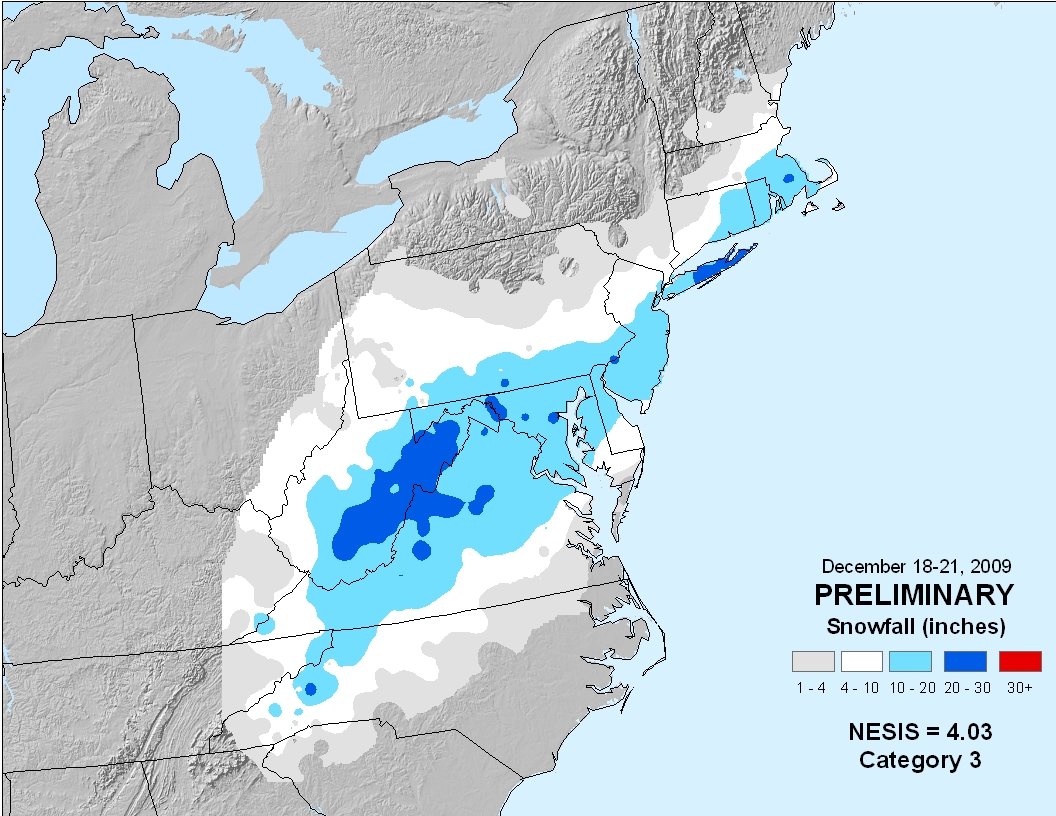
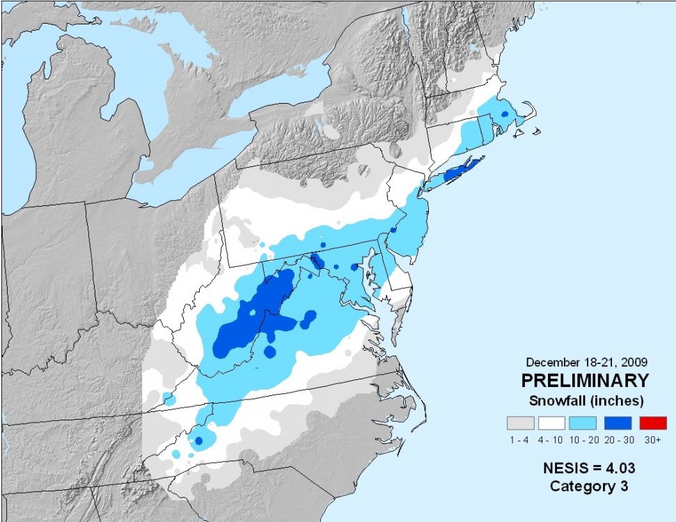
This one has I'm sure been overshadowed by more recent storms, but 10 years ago today, this was an all timer for Long Island and the mid-Atlantic and MECS for NYC.
-
DCA: +5.5 and 0.25", good for 2nd warmest and 3rd driest IAD: +4.6 and 0.41", good for 3rd warmest and 2nd driest
-
BWI: 11/7 IAD: 11/7 DCA: 11/25 RIC: 12/2 Tierbreaker: 10.24"
-
Central/Western Medium-Long Range Discussion
Winter Wizard replied to andyhb's topic in Central/Western States
Going to be out storm chasing in the Plains from 5/7 to 5/17. Pattern isn't the most favorable, but should still get a few solid chase days in.