FallsLake
-
Posts
6,317 -
Joined
-
Last visited
Content Type
Profiles
Blogs
Forums
American Weather
Media Demo
Store
Gallery
Everything posted by FallsLake
-
One great thing about our area, we can get the big storm. We fall short more than we win, but ever so often...…...
-
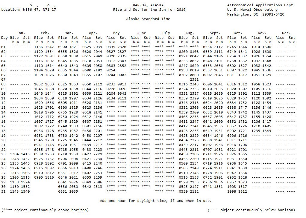
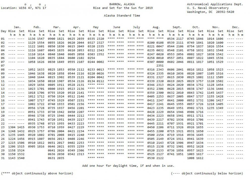
Here's something small to celebrate; the sun sets at Barrow Alaska tonight (first time since spring).
-
Yeah even though it's very rare, it's something we can hope to see again in the future.
-
Thanks for the great response!! I'm actually coping this post for future reference. Your probably right about the underlying reason for the article. And we very well could be f*!&ed. But (if we want to very selfish and shortsighted), if the arctic is going to hell we might as well score some good winter storms.
-
I'm definitely with you on truly wanting/wishing that the ice lose would reverse course; which it looks like it will not anytime soon. But saying that, what do you think of the concept that as the Arctic warms, lower latitudes could cool (especially in winter). https://news.nationalgeographic.com/2017/07/global-warming-arctic-colder-winters-climate-change-spd/ ** I suppose this could also go along with the idea that the Gulf stream could slow or stop...
-
Here's a good discussion (..at the end it turns to a debate) on lake effect snows for central and eastern NC. There are some good example links for 2003 and 2009. https://cimmse.wordpress.com/2014/02/05/an-examination-of-lake-enhanced-snow-across-central-nc-on-22-january-2014-2/ As a side note: While living in Wake Forest back in the 90s, we had a similar event whereas a cold front passed and a nearly stationary thin band of snow formed over northern Wake County. Ended up with ~1" of snow (nothing was forecasted).
-
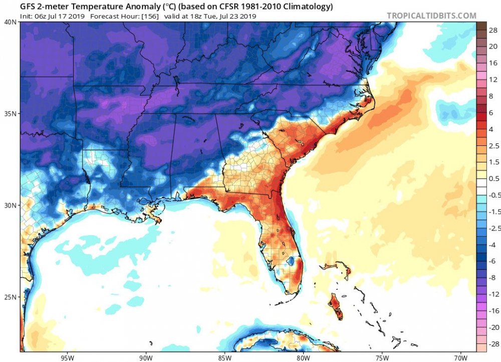
From RAH: The heat wave is expected to break Monday into Tuesday in a big way. Heights fall giving way to a large scale cold front that will move into the region late Monday and Tuesday. The front may stall or linger into Wednesday. Moisture pooling and strong convergence should bring a good chance of thunderstorms and showers, with considerable cooling as well. Highs by Tuesday and Wednesday should hold in the 80s, possibly some 70s over the northern Piedmont Tuesday and Wednesday!
-
I've had some rain at my location but not as much as others. Next week should provide more widespread rain. One of the GFS runs had temps in the 60s at noon for one of the days. That would be amazing for July.
-
If the models are correct, it would cool down towards your area the next day. Hopefully most of us can get a break.
-
Hopefully we can get a break early next week: From RAH: The chances of much needed showers and thunderstorms are expected to increase by Monday into next week as a pattern change to less ridging and more troughing over the region occurs. A cold front or two should stall over the region during this time frame acting as a focus for convection.
-
Had a great storm a couple hours back. Got right at 2". Really needed it.
-
Being a weather nut, I would prefer a nice lightning show over a man-made one any day.
-
^^RAH back to the doom and gloom for the 4th: Thu/Thu night: The potential for both thunderstorms and high heat indices remain the biggest weather concerns for the 4th of July. PW will be anomalously high, nearing or perhaps exceeding the daily record, as the weak surface wind field along the Piedmont trough makes for stagnant air, contributing to the stifling heat. Thicknesses are likely to be 10-15 m above normal with deep mixing. While forecast soundings and the steering flow pattern suggest that there should be considerable mid and high cloudiness, a brief capping near 850 mb Thu morning may initially inhibit cu formation, leading to increased insolation. Highs should be in the low-mid 90s, and with expected dewpoints in the low-mid 70s, a heat index ranging from the upper 90s to lower 100s is reasonable. Those outdoors and not taking breaks in air conditioning will need to be mindful of threats posed by heat illnesses in such conditions. The very weak mid level flow featuring multiple hard-to-track perturbations within a very moist column should result in a high pop but with low timing and spatial predictability. Given the precip variation among large scale models, will cap thunderstorm pops at around 50% late in the day through evening (potentially interfering with holiday activities), with a tapering down to lower chance late overnight. I would not be at all surprised to see all models trending even wetter for the 4th in their later runs. And with weak steering, moderate CAPE, and high PW, heavy downpours could produce pockets of high, flooding totals.
-
Here's a good link of weather hazards from NOAA (...quick catch all): https://noaa.maps.arcgis.com/apps/MapSeries/index.html?appid=cf93575e5535467199da7358ee6c825c
-
Happy Summer Solstice everybody! Good news: The length of daylight will now start to shorten with each passing day. Bad news: It will continue to warm for about another month. **we have to reach equilibrium.
-
You'll eventually get some rain if the models are even half right.
-
Finally!!! 1.02" at the house. Had a heavy downpour with some nice wind gust. The monkey is off the back...
-
Don't want the severe weather, but would love to see the better rain coverage folks to our SW are currently getting.
-
Looks like we get more chances for rain starting this Wednesday. Most of the models show ~ 1-2" during the next week. LR models show the possibility of some cool days here and there (..big variations of when). Any cool days we get this time of year should be treasured.
-
Bad for the hail, great for the rain. I feel lucky to have the .09" from the first band. Really hoping for a little more with the second band.
-
We're at such an extreme that something has to give. Even going to normal or slightly above would be a win right now. **but the 12z models continue to show the cool down starting this weekend.
-
Long range models do show the extreme heat being knocked back starting this weekend. Even some dew points in the 40s in the extended. Hopefully that holds....
-
Grid forecast has me at 98 next Wednesday. And just think, in three months from now it will still be only August. This is going to be a long summer.....
-
We definitely had the AO negative but the NAO kept to its recent history and stayed mostly positive. We even had the PNA go negative for the month of February (which it had been the one thing we could count on). But (I agree), I also heard folks blame the MJO.
-
If we had the current/forecasted indices during the winter, we'd be in business. +PNA, -NAO, and -AO. https://www.cpc.ncep.noaa.gov/products/precip/CWlink/daily_ao_index/teleconnections.shtml I suppose it can still help keep troughs in the east (..which is forecasted), but the farther into spring we get the less south they can push.