SouthCoastMA
-
Posts
8,538 -
Joined
-
Last visited
Content Type
Profiles
Blogs
Forums
American Weather
Media Demo
Store
Gallery
Everything posted by SouthCoastMA
-

"Don’t do it" 2026 Blizzard obs, updates and pictures.
SouthCoastMA replied to Ginx snewx's topic in New England
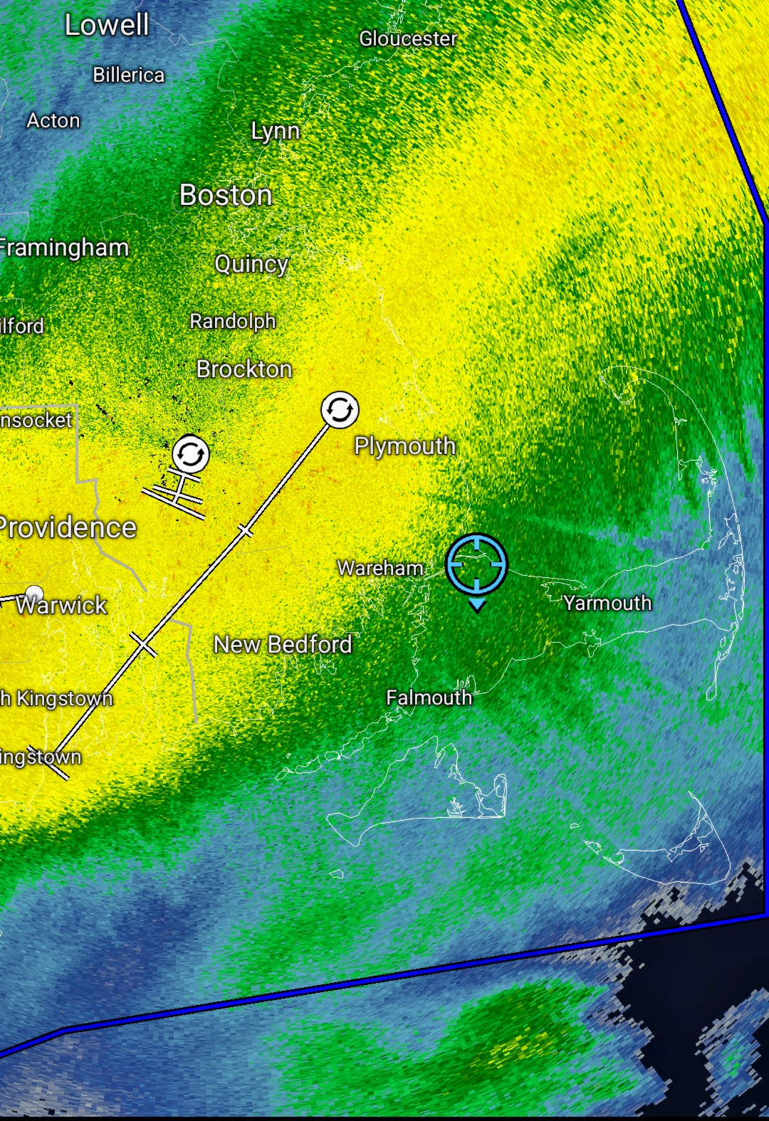
Getting close to its annual average with one storm is impressive. -
"Don’t do it" 2026 Blizzard obs, updates and pictures.
SouthCoastMA replied to Ginx snewx's topic in New England
Might actually be pivoting a bit now. -
"Don’t do it" 2026 Blizzard obs, updates and pictures.
SouthCoastMA replied to Ginx snewx's topic in New England
That whole area is like 24-30 -
"Don’t do it" 2026 Blizzard obs, updates and pictures.
SouthCoastMA replied to Ginx snewx's topic in New England
Yeah it's still snowing but light to mod. need that to shift a bit more. once winds go due North I guess, but then it will start drying up -
"Don’t do it" 2026 Blizzard obs, updates and pictures.
SouthCoastMA replied to Ginx snewx's topic in New England
Brutal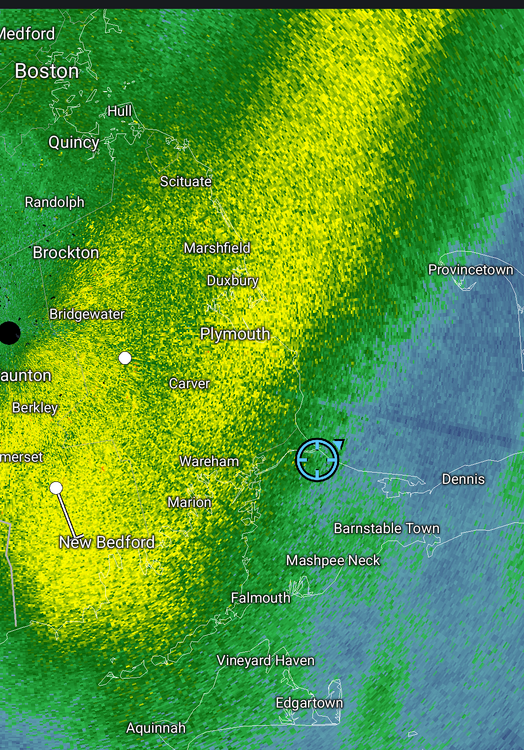
-
"Don’t do it" 2026 Blizzard obs, updates and pictures.
SouthCoastMA replied to Ginx snewx's topic in New England
Just lost power. I'm must've been one of the few left on the Cape to lose it this late -
"Don’t do it" 2026 Blizzard obs, updates and pictures.
SouthCoastMA replied to Ginx snewx's topic in New England
It's been decent the last hour, hopefully can add a few this afternoon to make it respectable, relatively speaking. The wind has been super impressive -
"Don’t do it" 2026 Blizzard obs, updates and pictures.
SouthCoastMA replied to Ginx snewx's topic in New England
what a cocktease here. just stalled 10 miles to my west and not budging -
"Don’t do it" 2026 Blizzard obs, updates and pictures.
SouthCoastMA replied to Ginx snewx's topic in New England
wtf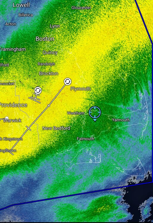
-
"Don’t do it" 2026 Blizzard obs, updates and pictures.
SouthCoastMA replied to Ginx snewx's topic in New England
Best has definitely been to west of me..but gotta be somewhere in 10-12" range. Wonder if that fronto pushes east a bit -
"Don’t do it" 2026 Blizzard obs, updates and pictures.
SouthCoastMA replied to Ginx snewx's topic in New England
gust to 72 close by winds are really amping up now -
"Don’t do it" 2026 Blizzard obs, updates and pictures.
SouthCoastMA replied to Ginx snewx's topic in New England
Kingstown RI will end up between 30-36" if this continues -
“Cory’s in NYC! Let’s HECS!” Feb. 22-24 Disco
SouthCoastMA replied to TheSnowman's topic in New England
NAMs are still 1.7"+ for you -
“Cory’s in NYC! Let’s HECS!” Feb. 22-24 Disco
SouthCoastMA replied to TheSnowman's topic in New England
you'll get 15-18". enjoy -
“Cory’s in NYC! Let’s HECS!” Feb. 22-24 Disco
SouthCoastMA replied to TheSnowman's topic in New England
maybe WeatherGeek can filter that through AI to get a more futuristic aesthetic -
"Don’t do it" 2026 Blizzard obs, updates and pictures.
SouthCoastMA replied to Ginx snewx's topic in New England
Be careful with transport -
“Cory’s in NYC! Let’s HECS!” Feb. 22-24 Disco
SouthCoastMA replied to TheSnowman's topic in New England
In an email, Eversource setting the bar super low, saying 3-5 days for power restoration . im effed -
“Cory’s in NYC! Let’s HECS!” Feb. 22-24 Disco
SouthCoastMA replied to TheSnowman's topic in New England
Me too. I'll get weenied for that though -
“Cory’s in NYC! Let’s HECS!” Feb. 22-24 Disco
SouthCoastMA replied to TheSnowman's topic in New England
3.2"+ at my old house in Acushnet on 3k NAM -
“Cory’s in NYC! Let’s HECS!” Feb. 22-24 Disco
SouthCoastMA replied to TheSnowman's topic in New England
The NAM slays, as some would say -
“Cory’s in NYC! Let’s HECS!” Feb. 22-24 Disco
SouthCoastMA replied to TheSnowman's topic in New England
you are in a great spot to maximize this one. -
“Cory’s in NYC! Let’s HECS!” Feb. 22-24 Disco
SouthCoastMA replied to TheSnowman's topic in New England
Jimbo looking like a grizzled veteran, ready to bask in some +TSSN -
“Cory’s in NYC! Let’s HECS!” Feb. 22-24 Disco
SouthCoastMA replied to TheSnowman's topic in New England
Only comparing to 0z, upped the qpf a tad down this way -
“Cory’s in NYC! Let’s HECS!” Feb. 22-24 Disco
SouthCoastMA replied to TheSnowman's topic in New England
Prob ride the mesos now. Let's see what euro does -
“Cory’s in NYC! Let’s HECS!” Feb. 22-24 Disco
SouthCoastMA replied to TheSnowman's topic in New England
Overall, 12z was a cutback, aside from the Germans