

SouthCoastMA
-
Posts
8,542 -
Joined
-
Last visited
Content Type
Profiles
Blogs
Forums
American Weather
Media Demo
Store
Gallery
Everything posted by SouthCoastMA
-
60" here. PYM county definitely had more than me in several storms.
-
Went from 3.39 to 4.49 a/gal over the weekend, and I'm due for a fill up on 3/11. Fun times Lets get this warmth in here.
-
I'm ready to warm up and close the shades til around St Patrick's day for one last chance at something worthwhile. Unfortunately I think we are due for an ick Spring, especially with those SSTs
-
48.4° lot of drippage
-
Pack from Jan 25th through Feb 28th+ must be some kind of record here on the Cape. 2015 was great but had a few skunkers in early February iirc. And as historic as 2005 was , I'm not sure we accomplished that. So it has been at least 21 years.
-
Of course, I moved from here to Sandwich in 2020. and Of course, I wasn't in Sandwich for Jan 27, 2015 Missed both maxes due to bad timing. I won't complain much outside of those two storms though. For instance, 2/14/15 was epic in Acushnet
-
Was that also the 32.1° wet bulb storm for many well inland, resulting in heavy rain. Could be mixing it up, but I remember there being a benchmark storm around then that left a lot to be desired
-

"Don’t do it" 2026 Blizzard obs, updates and pictures.
SouthCoastMA replied to Ginx snewx's topic in New England
Dick Slanting? or Slant Dicking? -
It did. It was a little rough being on the outside looking in for that 3-4 hour stretch, where it was like .5-1.5"/hr while just over the canal and beyond as 3-4"/hr but we did dance with good echoes often...especially the first half of the storm, and last several hours.
-
Before the Blizzard, I had a 5 x 5' patch of lawn appear in the front yard. Vibrant green still
-
Oh I see what I did. I referenced the ESandwich Cocorahs..not the COOP. The ESandwich Coop (21") definitely sounds more reliable than the CoCoRahs report (31" and 5" of qpf ) Sorry for the confusion!
-
I mean, it was measured there. I only estimated, and I could be underselling a few inches. You're right, just over the canal are some upper 20's/low 30's, which is literally only 5-10 miles from me. I wish there were more reports for Sandwich, but I understand that has been tough with the power situation on the Cape.
-
No winter related Will posts in March for several consecutive days. I know that really weakens his ACATT resolve.
-
AI trending a bit north for Monday, but looks light. Also suggests a cold reload around 3/13-14, so maybe we can score something around mid-month/Patty's Day.
-
The 31" ESandwich cocorahs total seems a bit inflated but dunno. it's possible I had a bit more than 21" but doubt 10" more
-
Lets do a 3/21/14 redux but 25-50 miles west and call it a day.
-
12z CMC now has it, but on Tuesday.
-
AIGFS also north. Even still, not much more than an inch On an island again - But I think this time it caves hard
-
"Don’t do it" 2026 Blizzard obs, updates and pictures.
SouthCoastMA replied to Ginx snewx's topic in New England
From a Cape perspective, I think the mid-level low position/banding is why we almost never jackpot with a benchmark track or even slightly SE, especially with no stall. 05 is one of the few exceptions because of the prolonged enhancement with arctic temps infused, and slow movement. You could argue we were co-jacks with with South Shore/North Shore on that one anyway. With that, each storm is different, and I suppose the 700/850 aren't always positioned the same wrt the SLP -
"Don’t do it" 2026 Blizzard obs, updates and pictures.
SouthCoastMA replied to Ginx snewx's topic in New England
I was trying to make him feel better by locking in 15-18" for him the night before. He was not having any of it, and even that was too low -
"Don’t do it" 2026 Blizzard obs, updates and pictures.
SouthCoastMA replied to Ginx snewx's topic in New England
-
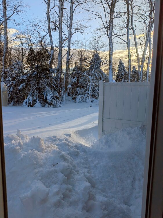
Going with 21" forgotten yardstick in backyard was @ 30", but slightly slanted from the wind (lol). Also started at 7" from previous depth. ESandwich Coop was 18", but my locale was in the death band eastern fringes more frequently. 8-10 miles to my west and north had close to 30". Forestdale reported over 20", to my SE. Depth and drifts with this well exceed Jan 22. I feel confident in my estimate within 1 or 2" Although a bit disappointed I missed out on the extra 9-10" by only a few miles, still a top 5'er personally
-
"Don’t do it" 2026 Blizzard obs, updates and pictures.
SouthCoastMA replied to Ginx snewx's topic in New England
Yeah, still out here -
"Don’t do it" 2026 Blizzard obs, updates and pictures.
SouthCoastMA replied to Ginx snewx's topic in New England
This looks much worse than Jan 22 here, despite my complaining about being just east of the 3ft band. Gotta be at least 20"..drifts are gigantic. Unfortunately I can't measure


