

olafminesaw
-
Posts
3,052 -
Joined
-
Last visited
Content Type
Profiles
Blogs
Forums
American Weather
Media Demo
Store
Gallery
Posts posted by olafminesaw
-
-
Time to start paying attention to our next tropical(ish) threat. Whether or not it gains tropical characteristics, we could see higher winds than one would normally expect from a system of it's strength, due to the interaction with the high to the north. Heavy rain possible for the coastal plain, with the I95 corridor being the current cutoff for heavier rainfall (subject to adjustment East or west)

-
 2
2
-
 1
1
-
-
A little home brew weenie bait

-
2
-
 2
2
-
-
7 minutes ago, emblaze2 said:
Who named the storm "Daniel"? I see the name repeatedly in media reports, but no mention of what agency or organization baptized it.
The Hellenic National Meteorological Service per wikipedia.
-
1
-
-
-
Mmm. Cinnamon rolls

-
1
-
 4
4
-
-
36 minutes ago, NJwx85 said:
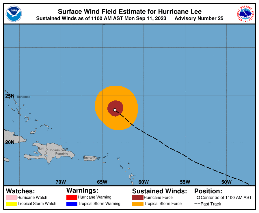
Just to give an idea on the massive size of the wind field. Also, notice the increased winds along the coast thanks to the tightening gradient between the high and Lee

Yep, 30 mph sustained winds at Hatteras and 10-15 foot waves. 2 to 4 feet of Coastal flooding as well.
-
Storm total from yesterday 3.18 at the gauge about half a mile from my house. The 30 minute total of 1.8" and the 2 hr total of 3.16 are both about 25 years floods per the precipitation frequency server. I was driving home in it near peak rainfall rates, thankfully my route didn't have any real low spots, but it was some of the toughest driving conditions I've been in
-
12 minutes ago, NorthHillsWx said:
Regardless where/if this comes ashore, I think the calling card will be rain and inland flooding. There’s really no baroclinic forcing or jet streak to enhance winds during the ET transition like some of the storms that hit up north and models are showing a rapid and normal decay of winds once this transitions over the wall of the Gulf Stream. Add into that, wind shear really peaks at 20-30kts by the time this is going by Bermuda and you have a rapidly weakening system before it hits the cold water north of the GS. Also, for a high latitude storm, this will be comparatively crawling in terms of forward speed (which will further decrease the wind threat). However, that slower than normal forward speed and tge potential for a bit of a pivot means that heavy tropical moisture will be thrust into the NW side of the system (normal during ET transition) and areas not accustomed to these tropical rain rates will have a prolonged rainstorm. I really think inland flooding with this could be significantly worse than many recent high latitude storms that were flying through when they impacted land. Though I think the wind threat has decreased significantly since even yesterday
Agreed, although coastal Maine is more vulnerable to wind damage than NS I would imagine. Looking back through records per Weather spark, gusts in the 50- 60 mph at Bar Harbor are much more rare (maybe once a year), compared to Halifax (3-5 times per year). NS also recently went through Fiona, so this should be no problem for them, while I believe it's been a while since Maine has had a storm of this magnitude. It seems plausible that a large area of the coast near landfall will experience high end TS to low end Hurricane force gusts
-
2
-
1
-
-
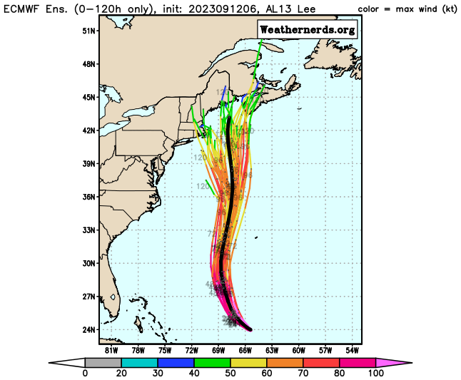
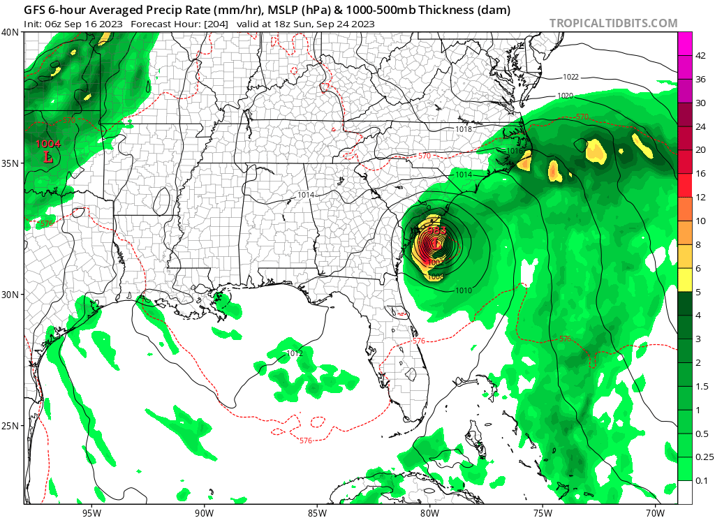
The Euro no longer is trying to deepen back to a cat 4, so we'll see if that has any effect on the track
-
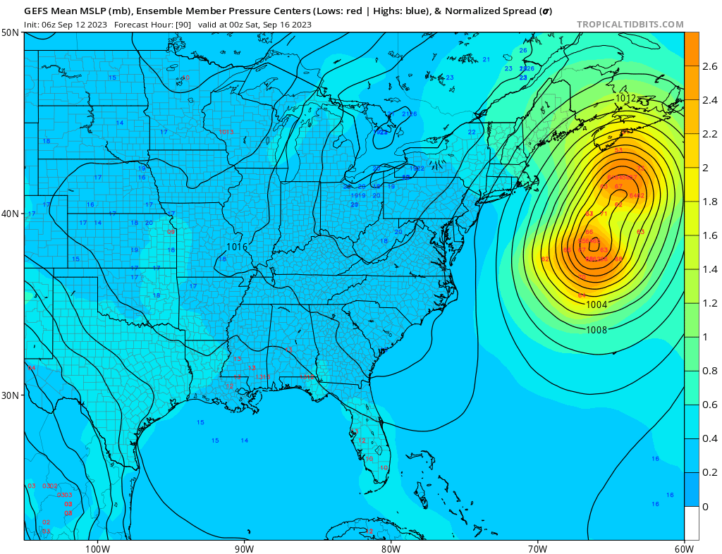
Three distinct clusters. So when combined with the GEFS something like, 15-20% chance of hooking into MA, 40% chance, landfall on the northern coast of Maine, 40% chance of missing right and hitting NS.
-
4
-
1
-
-
Two distinct camps between the faster members that miss right and the slower members that have the hook to the left. The thing is now many of even the slower members miss as they get too far east first and don't make as dramatic a turn as they were yesterday. This is the case with the EPS as well with the OP being a bit of an outlier. Coastal Maine is still in play though and effects could certainly be felt in eastern MA due to the size of the storm

-
1
-
-
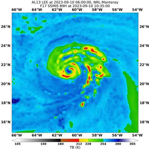
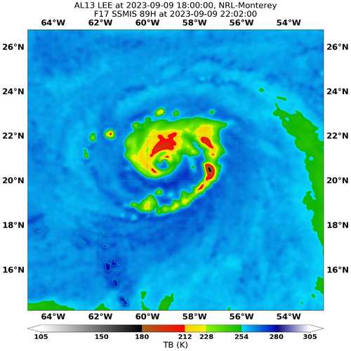
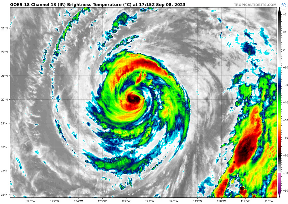
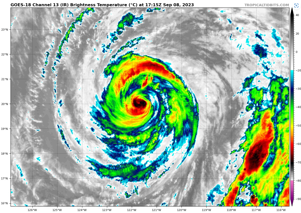
still some pesky convection in the old eyewall, but the new eye is really starting to rock and roll

-
1 hour ago, WxWatcher007 said:
What an eye developing on Lee.


Might take some time to clear out though (this a couple hours later)

-
1
-
-
Definitely expanding
-
4 minutes ago, NorthHillsWx said:
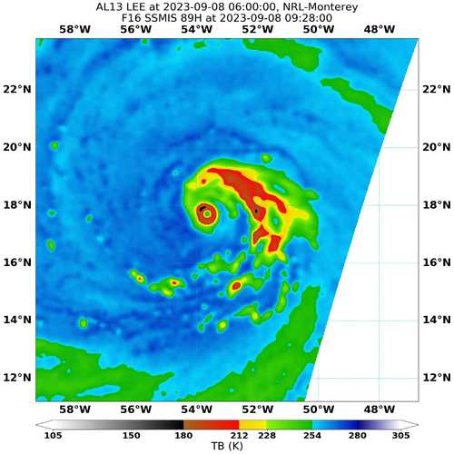
Recon is showing signs of a double wind maximum
The HAFS A and B both have it in the middle of a ERC and don't complete it for about 48 hours. The Navy.mil site seems to be down, so hard to say how far along the process is, but after the last ERC we were left with quite a bit of competing bands that held strength in check initially and ultimately led to our current ERC
-
Kinda a wonky structure, lots of banding.
-
Working through an ERC at the moment
-
2
-
-
Meanwhile Lee is looking much improved, if it can continue to wrap convection around the eye it may take off again sooner rather than later

-
1
-
-
The Euro has been all over the place. Swings between missing NS entirely to the East, and a US landfall almost every other run. The GFS meanwhile has been rock steady with a landfall on NS for days now.
-
14 minutes ago, BooneWX said:
I was told this thing was in a perfect environment with absolutely zero inhibitors for gaining strength. Looks like scrambled eggs this morning.
That's MAJOR HURRICANE scrambled eggs to you
-
1
-
-
31 minutes ago, Chrisrotary12 said:
Anyone have a graphic that shows the extent/size/how F'ng wide is this thing of Jova's circulation? Like its outer bands don't fit in the screen here:

-
1 minute ago, Hazey said:
Damn. That's like multiple gfs runs that are zeroing in on sw Nova Scotia. Still a long ways off but that's a bad track for up here. Lee better have crap beat out of it before it gets to this latitude. Yikes.
Yeah, it's been rock steady for several days now (keep in mind the heavy precip is west of the track).

-
Structure is impeccable. HAFS B suggests an ERC starting around 21-0Z this evening. Seems inevitable based on the size of the eye. But could see strengthening in the meantime
-
14 minutes ago, Random Chaos said:
Indications of a double maxima on recon, but it’s subtle. Probably the start of an ERC and if so likely the cause of the degraded appearance on satellite this morning:
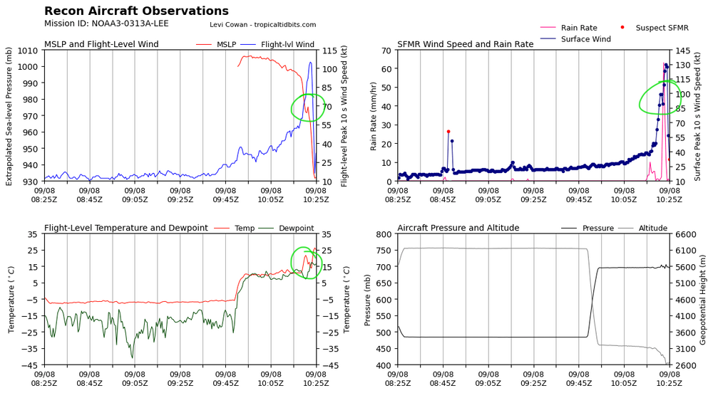
I think so, I don't think a little bit of shear would cause the eye to degrade on appearance and the pressure to rise so much in a such a short period of time without an ERC. Not any signs of one on microwave which could be just due to the low resolution/small core, but also could indicate more of a meld/quick ERC.


TS Ophelia
in Tropical Headquarters
Posted
The GFS is quicker to develop, and well west. I think the faster it can develop the more chance it has to move inland.