

olafminesaw
-
Posts
3,051 -
Joined
-
Last visited
Content Type
Profiles
Blogs
Forums
American Weather
Media Demo
Store
Gallery
Posts posted by olafminesaw
-
-
Ice ice baby?
-
2 hours ago, chapelhill said:
first sleet/snow clown map blip in 2 weeks on GFS... cross your fingers

We're due for a "kitchen sink" type storm that eventually gets washed away by cold rain. Lock it in.
-
3 minutes ago, eyewall said:
It is likely overdone to some degree but I would think more gusts to around 40-45.
Yeah honestly I'm a little surprised models are only forecasting 40-50 mph gusts considering their tendency to be overdone, particularly on the stronger Euro. It is really hard to get more than 45 mph winds in the Piedmont from baraclonic winds apart from some kind of jet enhancement/sting jet, which does not seem to be present in this case. We'll have to see what the mesoscale models show closer to the event, although they always need to be reduced by 30-50%.
-
1 hour ago, eyewall said:
Happy Hour GFS is way west
Brings the higher gusts all the way to the upslope region of the blue ridge, which also where flooding rain in that scenario would occur
-
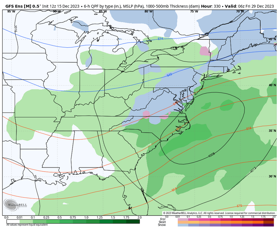
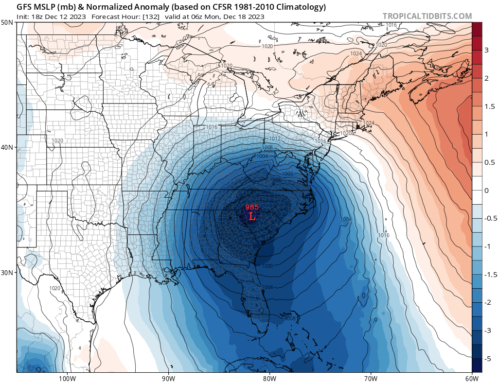
The Euro has a low 980s mb low going right through central NC. This would smash previous pressure records for the month of December. Kinda has the look of a subtropical storm coming up along the Gulf with a fairly tight pressure gradient

-
 4
4
-
-
Good to see the PNA trend more positive. Would at least get some cold air to this side of the continent
-
4
-
-
This next storm could be quite potent. If the GFS is to be believed it drops into the 1980s mb and brings some hefty winds to the area


-
2
-
 1
1
-
-
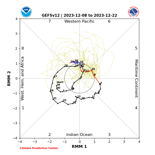
FWIW after delaying the transition to phase 8 of the MJO the past couple days, the most recent GEFS run sped up and gets us to phase 8 around Christmas. It would be hard to imagine that if this plays out we wouldn't see a marked improvement to the pattern.
.png.dba1d022b4f0b029799028adb3a405d8.png)
-
1
-
-
13 minutes ago, Bevo said:
It's like watching old TV shows in syndication.
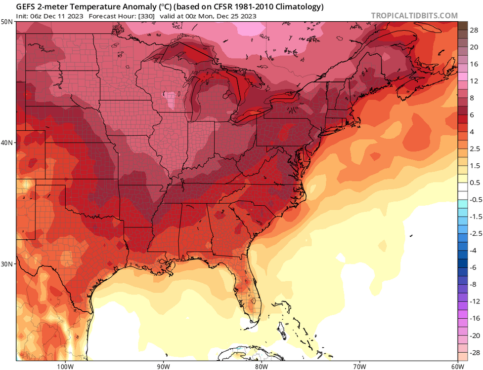
Unfortunately if the pattern change does occur it still doesn't necessarily look particularly cold and snowy for us. But it does seem likely we'll get out of the current pattern where Maine to Spokane are getting warm rain. Highly anomalous patterns don't last forever and El Nino tends to shuffle things up at some point
-
2
-
-
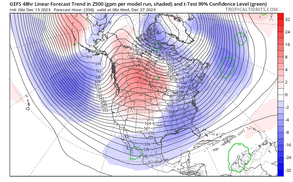
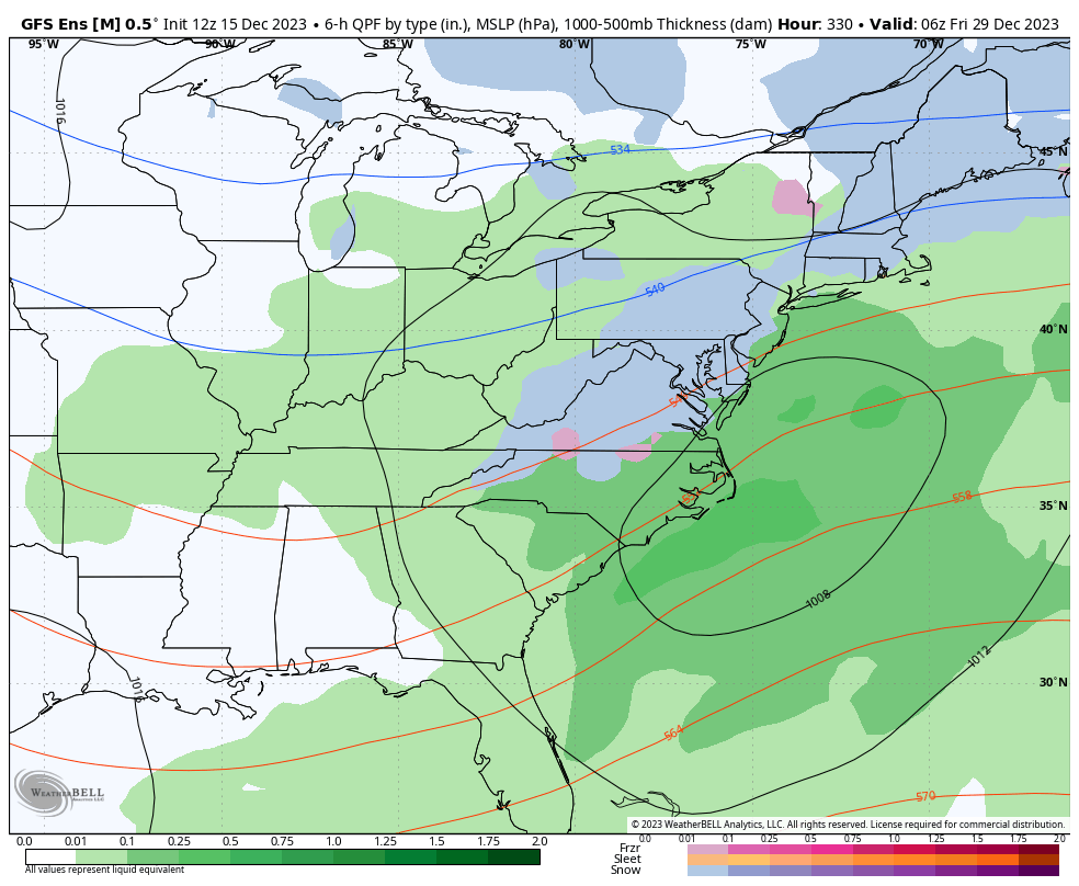
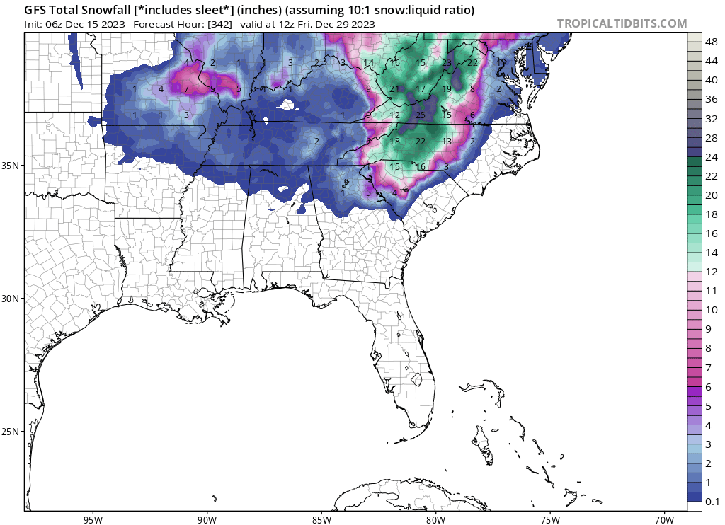
Pretty strong indications that the gears will start to turn on the pattern change in about 10 days. The cold air would begin to move across the CONUS around christmas and settle over the East Coast by the first week in January
.thumb.png.620e1e776d83f42c38bf98f6136e0a5b.png)
-
2
-
-
Going back 50 years at GSO, 62% of the time there is no measurable snow in the month of December. Of course when factoring in the December totals, years with snowfall in December have a higher average snowfall at 9.8" vs 6.5" in years without snow in December. However, when looking at January through April snowfall in isolation, there is no meaningful correlation to whether snow accumulates in the month of December (6.9" in years with snow in December vs 6.4 in years without). So going forward we shouldn't be pessimistic about our chances in the new Year, knowing that confidence in modeling more than 10 days out is near zero.
-
2
-
-
1 hour ago, NorthHillsWx said:
Im ok with it as long as we’re seeing some signs of something changing in early Jan. Otherwise, we’re going to be stuck in our can kicking pattern we have been in since December 2018
Let's not forget, last year around this time we were hoping for a massive Christmas blizzard and a solid pattern afterwards. We know how that turned out. All that to say, I'd rather be hoping for a pattern change now, considering El Ninos are typically more back-loaded.
-
52 minutes ago, NorthHillsWx said:
All indications seem to be pointing to a punt until early January at the earliest for sustained cold and snow chances outside the mountains. MJO and ensemble guidance is ugly. That being said, my brother is reporting about 1/2” of surprise snow from Urbanna Virginia this morning
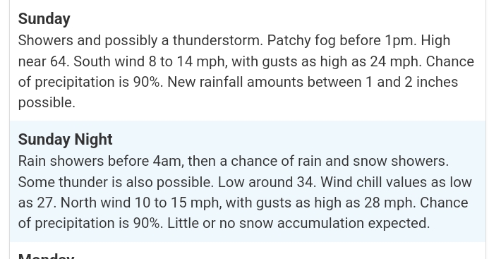
might be a T-shirt kind of Christmas.
-
1
-
1
-
-
Yesterday's rainfall of 2.86" at GSO not only sets a daily record at GSO, but also is the highest December daily rainfall since 1958. The storm total of 3.1" brings us up to just over average for the year.
-
1
-
-
Ayyy, let's get our .1" and beat last winter before Christmas.
-
2
-
-
Monday morning starting to look rather interesting, even on the gfs.
.thumb.png.d3e54c59f176d43a883c442519ed2183.png)
-
20 minutes ago, CAD_Wedge_NC said:
This is not a torch. I'll take phase 7 for now. You do realize that we will be going into phase 8 during peak climo.
Fair, torch is hyperbole and I'm optimistic on January FWIW. But this explains why the favorable window won't open until the very end of December at the earliest.

-
We're waiting for the MJO to move into phase 8. Until then, torch.
-
1
-
 1
1
-
-
-
51 minutes ago, Daniel Boone said:
The only mistake that forecaster is making is saying the snow " could be heavy". Should be "will be" , as is obvious.
Can you imagine that ?! Those rates !!!!!!
It's like the past 3 winters' snowfall every two hours through the night.
-
2
-
 1
1
-
1
-
-
19 hours ago, NorthHillsWx said:
Our winter is the Iowa offense. Getting our punter out early and often
I just daydream about being atop mount Rainier in times like these:

-
8
-
2
-
-
-
37 minutes ago, BooneWX said:
Possibly a biggie hitting the east coast next week. While it won’t mean much for us outside of the mountains, hopefully this can lay down a nice snow pack for a wedge to feed off of down the not so distant road.

Definitely not out of the question that the system could bring snow showers to the area, most likely just in the high elevations, but you never know with the cold air mass aloft. It will probably be too dry east of the mountains with that storm track though, after the frontal passage
-
3
-
-
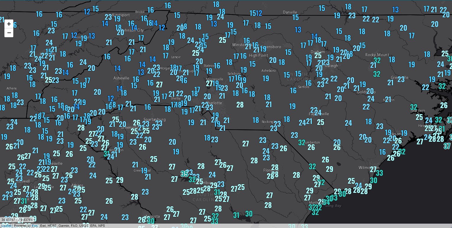
1 hour ago, WinstonSalemArlington said:
Widespread teens
The Low of 16 at Sanford is really impressive. Could be a record for the month of November, but I can't find that data.


.png.0a2c2b20c45b6b5e96498d44a2de039a.png)

.png.afa7912d9e2dd4bd83b83b40db6d5d86.png)


Mid to Long Range Discussion ~ 2023
in Southeastern States
Posted