

olafminesaw
-
Posts
3,054 -
Joined
-
Last visited
Content Type
Profiles
Blogs
Forums
American Weather
Media Demo
Store
Gallery
Posts posted by olafminesaw
-
-
The Euro and GFS both have temps over 100 on Friday at GSO (102 and 105). This would be the first 100 degree day since 2012 and the latest in the season since 1954. On average GSO reaches 100 about once every 5-10 years.
-
 1
1
-
-
8 hours ago, WinstonSalemArlington said:
91 yesterday at GSO. Even in the hottest patterns, it’s been really difficult to get impressive heat in the Triad this year.
Just in general I think the past few years. Going back to 2018, the highest temp of the year has been 95 or 96 every year.
-
Smol

-
 1
1
-
-
Models did pretty well at handling QPF for Socal.

-
Weenie alert issued for New England. Preposterous GFS runs possibly posted on Twitter over the coming days.
-
4
-
-
3 minutes ago, Rtd208 said:
LAFD stating the earthquake was center in Ventura County at a 5.1 magnitude.
In a pretty rugged area. Wonder if it triggered any landslides.
-
Definitely wouldn't think the upcoming period will be totally dead
-
10 minutes ago, SolidIcewx said:
Hella rain band about to move into the Salton Sea area
Kinda looks like it's starting to orient more N to S, which would be bad news bears for whoever gets stuck under the band.
-
The first real push of moisture of the main event making it's way into the high risk area. I would imagine the boiling hot waters of the Gulf of California will only intensify banding as the event progresses.

-
Lots of fish activity

-
1
-
1
-
 1
1
-
-
Already flash flooding in southern Nevada

-
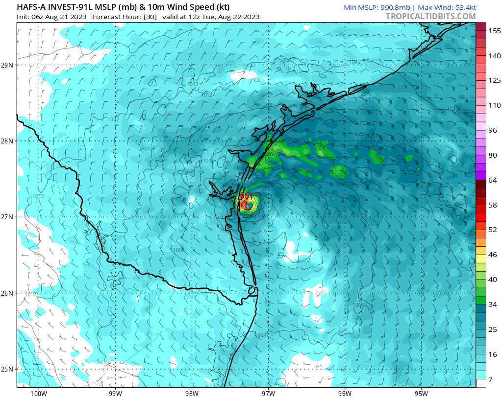
53 minutes ago, schoeppeya said:
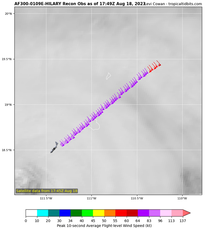
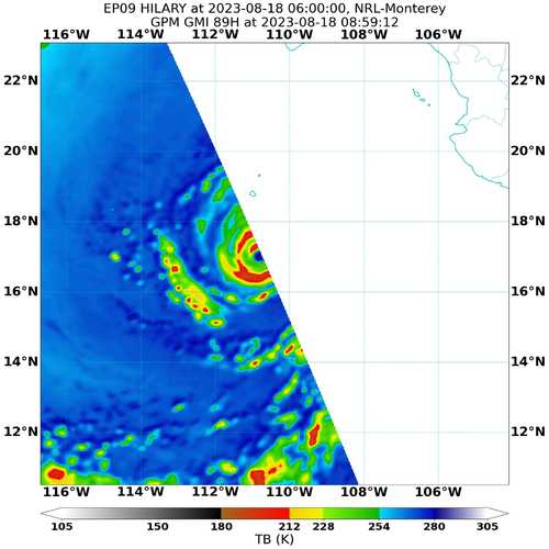
Looks like there another aircraft en route, should be great timing to capture whatever peak this thing is going for after the ERWC. Looks great on sat.
May just miss peak. It's about to move over much cooler waters.
-
Isla Socorro, which is about 80 miles East of where the center passed, recorded sustained winds of 45 mph and gusts of 70 mph
-
Just now, WxWatcher007 said:
Still on approach to the eye. Nothing surprising showing up yet. Spotty data coming in.
Seems the inner core is still quite small

-
1
-
-
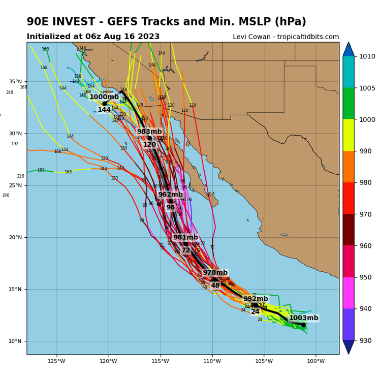
Climo is beginning to work in our favor, about 2/3 of the time the prior two weeks are hotter than the upcoming two weeks.
.thumb.png.e5bd9c496ba8ebb79e7f295bbb4fbc47.png)
-
2
-
 1
1
-
-
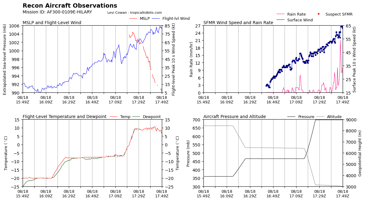
As much as it's disappointing to have missed the peak, this is vital data in terms of determining how quickly Hilary will regain strength. I suspect it's mixing out a bit of dry air ingested during the ERC and is just now starting to restrengthen, since the ERC completed several hours ago
-
6 minutes ago, WxWatcher007 said:
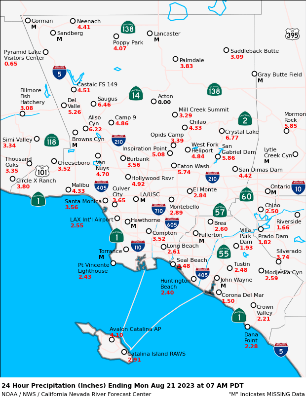
An exceptionally rare D3 high risk now issued. Catastrophic flooding is certainly on the table for some areas of the SW.
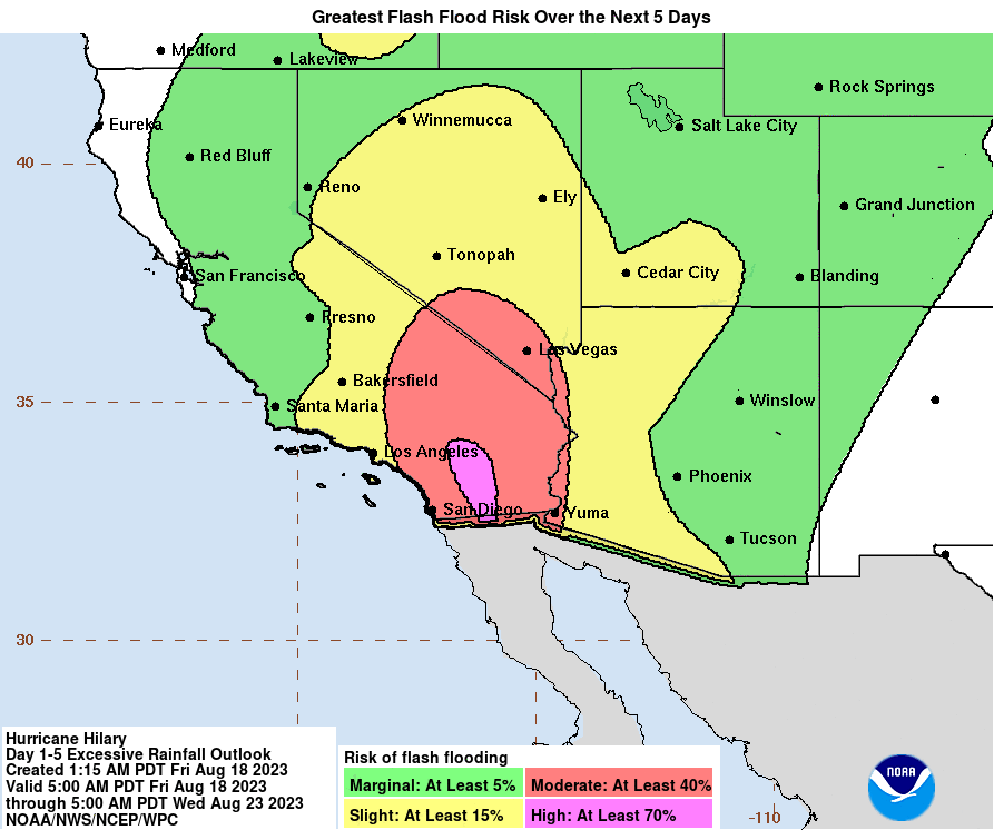
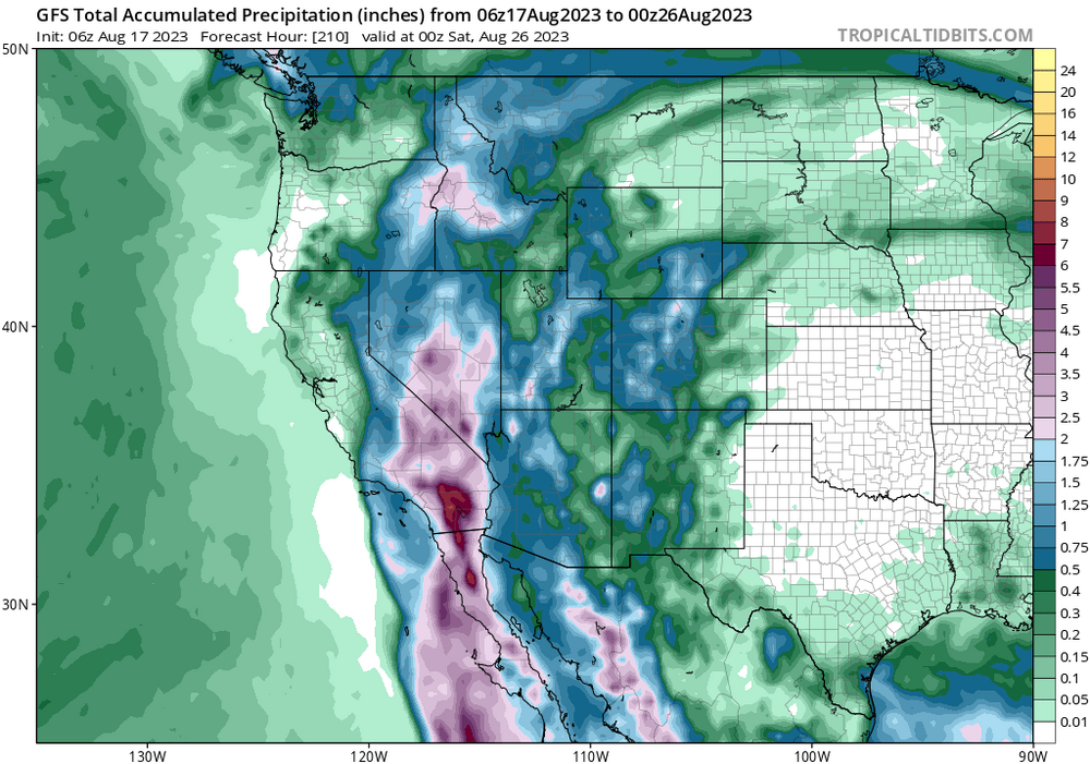
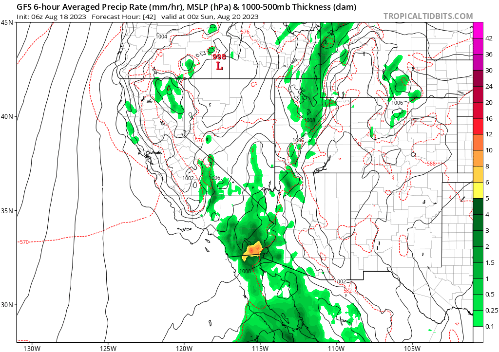
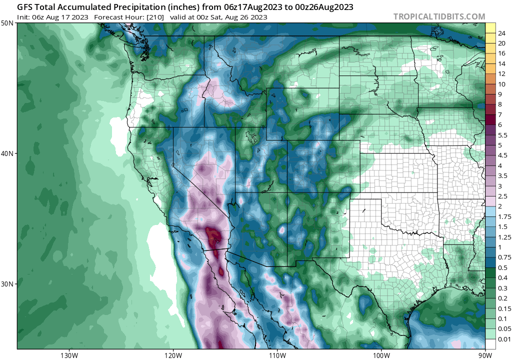
Excessive Rainfall Discussion
NWS Weather Prediction Center College Park MD
358 AM EDT Fri Aug 18 2023

Day 3
Valid 12Z Sun Aug 20 2023 - 12Z Mon Aug 21 2023

...A HIGH RISK OF EXCESSIVE RAINFALL EXISTS FOR THE PENINSULAR
RANGES OF SOUTHERN CALIFORNIA...

Portions of the West...
The guidance is unanimous in merging Hilary with an upper low
stuck near central CA.  Normally for a tropical cyclone this would
be a problem as convective lows would circle the periphery
parallel to 1000-500 hPa thickness lines, which would otherwise
turn it more north or north-northeast, but since Hilary should be
strongly shearing while moving over cold waters and transitioning
to a post-tropical or remnant low in the process, it should have
diminishing convection in its vicinity, so this isn't the typical
model bias (this time).  A large area of precipitable water values
of 1.75-2.5" will approach if not exceed all-time time records, so
there will be moisture to spare.  In the Southwest in particular,
flow at 750 hPa is expected to reach or exceed 65 kts, so heavy
upslope rains on the atypical sides of the southern Sierra Nevada
and Peninsula Ranges of CA are anticipated.  If the flow is more
southerly than expected due to a slightly more westerly track of
Hilary, there's a chance that both sides of the Peninsular Range
get heavy rainfall.  The NAEFS is indicating IVT values 14.8
sigmas above the mean.  Even assuming a non-standard distribution,
this is extreme.  There is a very real potential for 3" amounts in
an hour in this environment.  Some of the guidance shows local
amounts of 7"+, which would be exceeding rare for the region from
a tropical cyclone, potentially unique for Nevada.  The 100 year
ARI is forecast to be exceeded.  If a 7"+ maximum materialized
over Mount Charleston Sunday into early Monday, it would challenge
Nevada's 24 hour rainfall record, set in 2004.  Given the overall
uniqueness of this event, chose to upgrade to a High Risk for
areas near and east of the Peninsular Ranges of Southern CA.
The San Diego WFO has never been under a day 3 high risk. The last day 1 high risk was Feb 14 2019
-
1
-
-
Like like a plume of moisture (PRE? Atmospheric river?), could cause flash flooding well before Hillary arrives for the dry side of the divide

-
ERC well underway. Seems to be going rather smoothly.
-
1
-
-
Convection wrapped fully around the eye the past couple frames. Could easily be a major by 8pm
-
1
-
-
The Salton sea averages 5-6 inches of rain per year and the saline body of water is highly toxic. Honestly not sure what a years worth of rain in 48 hours will do.
-
1
-
-
11 minutes ago, Boston Bulldog said:
Some pretty remarkable Integrated Water Vapor Transport values associated with the modeling for our future system. Regardless of SLP track, the San Gabriels should get good drink. Primary concern would be mudslides if these depictions verify
Kathleen (1976)is a very good analog. Described as a 1 in 160 year event
https://en.m.wikipedia.org/wiki/Hurricane_Kathleen
-
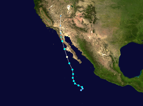
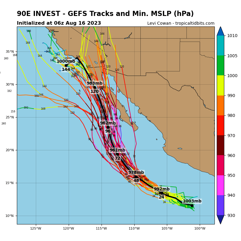
Pretty unbelievable honestly. I can't imagine more than a weak TS by the time it reaches CA, but could be a significant flood threat
-
TFW the first TS landfall in the US this season could be San Diego.


.png.167a9f93dbc993b2f84776bc8491cc55.png)

Hurricane Franklin
in Tropical Headquarters
Posted
I know! Don't think I've ever seen that, even with hurricanes that are already cat 5s