

olafminesaw
-
Posts
3,052 -
Joined
-
Last visited
Content Type
Profiles
Blogs
Forums
American Weather
Media Demo
Store
Gallery
Posts posted by olafminesaw
-
-
20 minutes ago, Sandstorm94 said:
Hey y'all, you know I have been around the form for years now (Orangeburgwx), but this gal has some exciting news to share!
This will be my last few months here full time in the Southeastern States board seeing as how I am moving to Vermont at the end of the year. I will still drop in from time to time on the banter form to check in since I care about you all, and good luck in Jan/Feb.
Also, the 6z GFS is such a fucking tease...
Sent from my SM-S146VL using Tapatalk
I'm jealous! About the snow yes. But mostly the hiking. By all accounts stunning scenery around every corner out that way. Going to miss you're posts, but I know you will pop in for the big blizzard we get right after your move

-
 1
1
-
 2
2
-
-
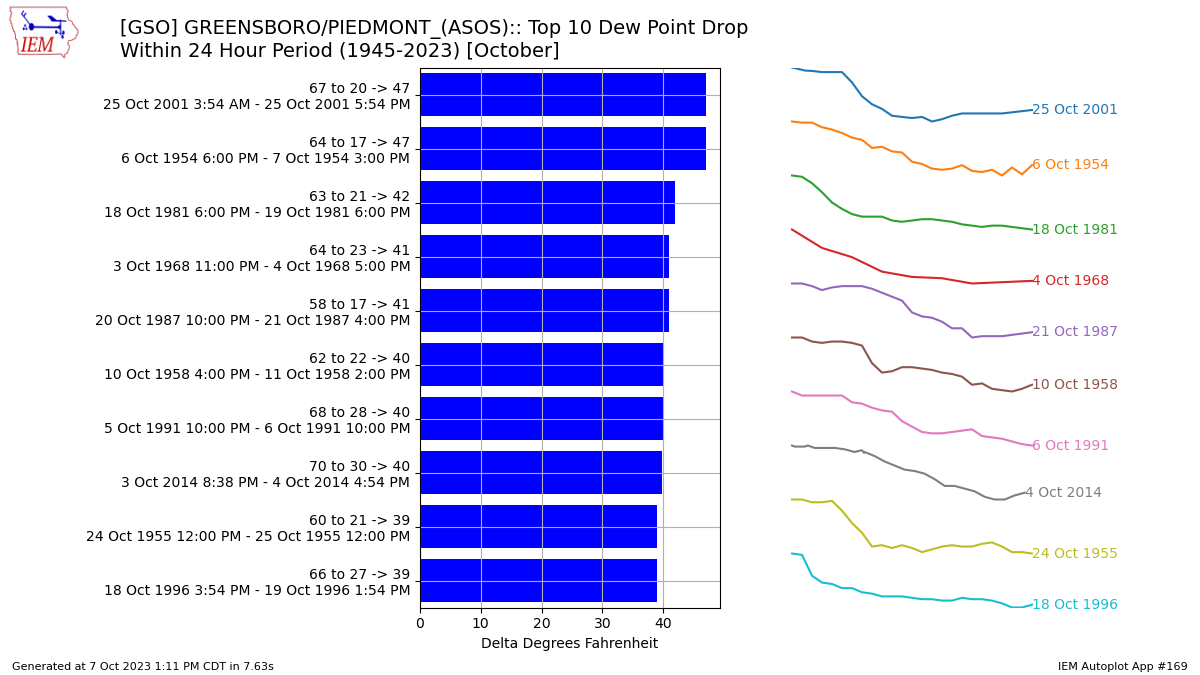
Pretty unusual to see as dramatic a drop in dewpoints in October. Going to bottom out in the upper 20s after being at 62 this morning. A drop of 35 in a 24 hour period would be just outside the top 10 for the month of October

-
2
-
-
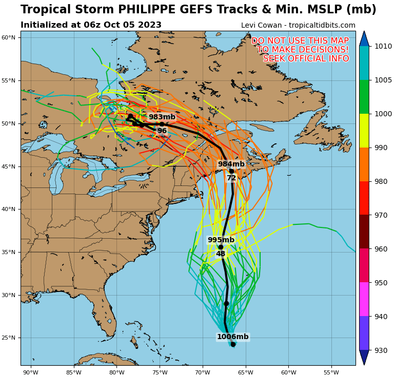
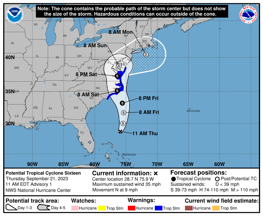
The cone vs ensemble spread is kinda wild
-
1 hour ago, GaWx said:
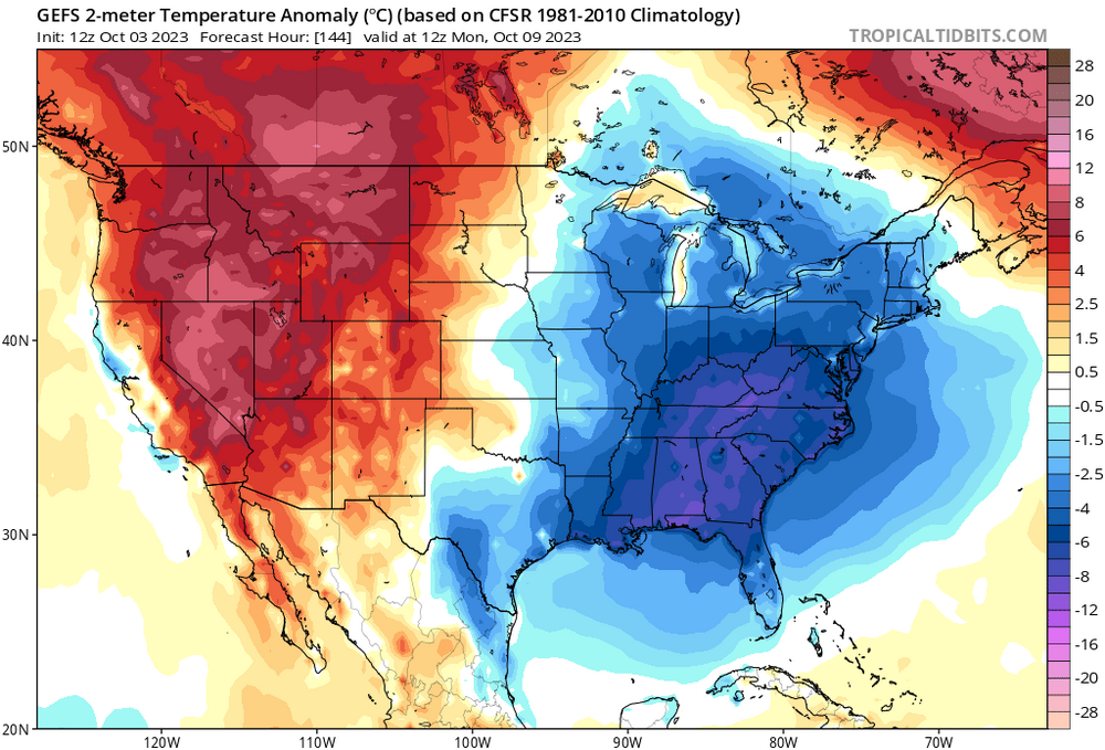
GEFS is still suggesting high chance for a +PNA for October as a whole with a likely +2+ peak in the dailies coming early next week. Hoping Oct doesn’t come in with too high of a +PNA, however:

Is our upcoming cold(ish) snap a direct result of the spike in PNA?
-
1
-
-
3 minutes ago, NorthHillsWx said:
Per recon, radar, and sat, I’m not sure Philippe still has a closed center or meets criteria to still be a storm. Looks to have opened up
A hot mess indeed. CNN is currently running a story with the headline "an unusually hot Atlantic Ocean is neutralizing El Nino. That could be bad news for the rest of hurricane season." Right on cue, the Atlantic seems to have flipped a switch to it's usual hostile El Nino state. Shear all over the place and little signs of development.
-
 2
2
-
-
Nom nom

-
2
-
-
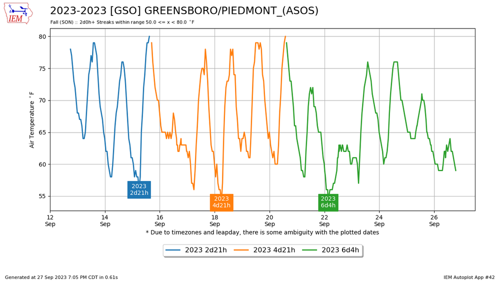
Absolutely! The best way to measure such a streak I can think of is to count consecutive days between 40 and 80 degrees, as these temps roughly delineate summer from fall from winter. More than about ten straight days is somewhat rare which is a bit surprising. In data going back to 1980, 2003 was the grandaddy of all falls with not one, but two streaks of 10 days plus. Also, between Sept 20 and Oct 20 is the typical time range for "true fall" (if you will) is to occur. This year could have had a good streak going, but a couple warm days interrupted it. Even so, it has been consistently fall-like and should remain so for the foreseeable future, and should make a run at an impressive streak!

-
1
-
-
38 minutes ago, MJO812 said:
This is a change from past runs where the models had Phillipe staying way out to sea.

Really hard to predict track with the system behind it having some influence and possibly Fujiwara effect. A weaker system should come more south though and they are leaning hard on the Euro
-
1
-
-
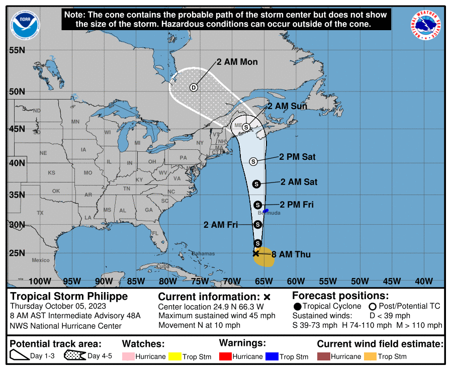
1 hour ago, NJsnow89 said:
When do the worst of the winds start for central NC
A slow ramp up but probably starting sometime between 3 and 5 am
-
Area of highest winds seems to be expanding rather than increasing. Consistent with most models in this regard.
-
1
-
 1
1
-
-
Mostly clear with some thin cirus and a handful of little whispy clouds zipping along at a quick pace in Greensboro. Strange sunset lighting with more clouds cover to the East muting the blue sky. Rather breezier than I would have expected although the bendy oaks can be decieving. Hoping for a slower landfall and thus experience a little of the fun in the AM (even though it shouldn't get too exciting anyway)
-
-
-
Just now, Amped said:
I'm surprised they didn't go with subtropical. Looking at phase space diagrams there's is a pretty shallow warm core and doesn't have much symmetry.
Yeah, doesn't look stacked at all (more evident on loop). Kinda neat though!

-
Ophelia has a rather unusual trajectory, moving NNW at landfall. I can't find any TSs or Hurricanes in the NOAA database along the NC coast that are close. Most move NE, with a number of outliers moving more W or WNW
-
1
-
1
-
-
14 minutes ago, NorthHillsWx said:
Cape lookout (on land) sustained 40 kts Gusting 48 kts
Higher winds should be pushing inland through the afternoon

-
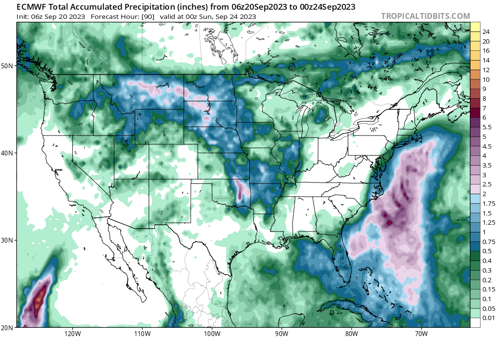
The 12z GFS took a sizeable jump west and now brings 2-3" of rain to the Triad. It also brings higher (50mph +) gusts to Raleigh
-
60 mph at landfall
-
2
-
1
-
-
11 minutes ago, WxWatcher007 said:
Seeing that LLC become better defined, but like the NHC stated, center reformations will be possible. We'll see how the next few hours go, but it's coming together. Likely won't become tropical until it's closing in on NC.
This is a good point, because reformation adds uncertainty to the track. Hopefully the 18z HAFS will shed some light on the evolution. Seeing all that lightning arcing around the circulation leads me to believe this is developing rather quickly.
-
34 minutes ago, WxWatcher007 said:
Now designated as Invest 99L.
It will be nice to get the hurricane models in on the action as well
-
2
-
-
51 minutes ago, mob1 said:
06Z Euro has a deeper storm now
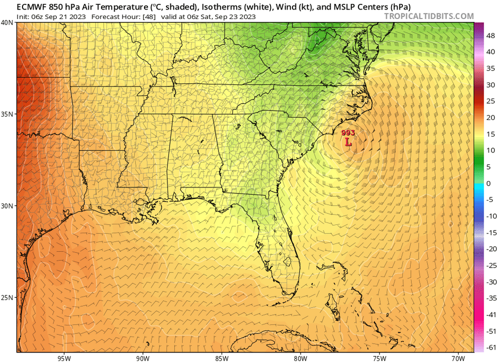
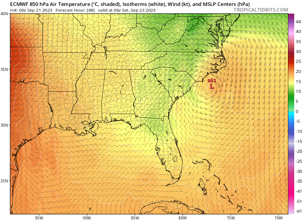
Also moving more due N rather than NE, as depicted by the GFS, at landfall. Indicates more impact further inland. I think I95 East is a near lock for a moderate impact event. And between Raleigh and I95 is still up in the air depending on track. The Western piedmont should be relatively low impact as of now
-
33 minutes ago, WinterWolf said:
Isn’t that kind of the norm now? I mean 3-5 yrs ago, we’d know pretty much know what to expect from this at 72 hrs. Now it’s pretty much like every system has to be 12 hrs out to have any confidence anymore…it’s frustrating.
I really think it just feels this way. We've gotten a lot more detailed maps and so much more data to sift through over the past few years. Most of the time it's people paying too much attention to outliers. In this case I do think we have a lower confidence forecast than normal
-
The 6z Euro is really keeping it weak and offshore

-
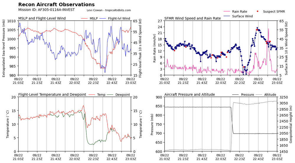
First pass suggests current intensity of 90mph is about right. Need to wait for it to sample the southern eyewall, but they got 75 kts in the northern eyewall
-
1
-


.png.db11be8ef110dcba7b6932216245fdee.png)


2023 Atlantic Hurricane season
in Tropical Headquarters
Posted
The wind shear over the SE US is incredible. Not sure I've seen values over 100 before.