

olafminesaw
-
Posts
3,054 -
Joined
-
Last visited
Content Type
Profiles
Blogs
Forums
American Weather
Media Demo
Store
Gallery
Posts posted by olafminesaw
-
-
14 minutes ago, Random Chaos said:
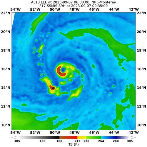
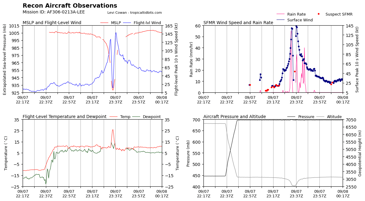
Indications of a double maxima on recon, but it’s subtle. Probably the start of an ERC and if so likely the cause of the degraded appearance on satellite this morning:
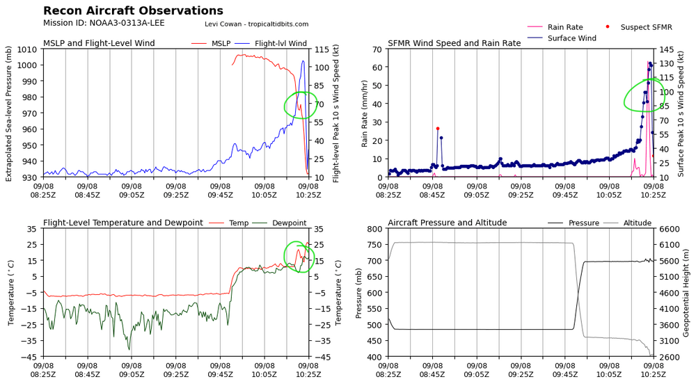
I think so, I don't think a little bit of shear would cause the eye to degrade on appearance and the pressure to rise so much in a such a short period of time without an ERC. Not any signs of one on microwave which could be just due to the low resolution/small core, but also could indicate more of a meld/quick ERC.
-
Missing pressure data at the moment. Hopefully temporary
-
Sure why not reload and try again

-
 2
2
-
-
Am I seeing a hint of a double wind maxima? Or just noise?
-
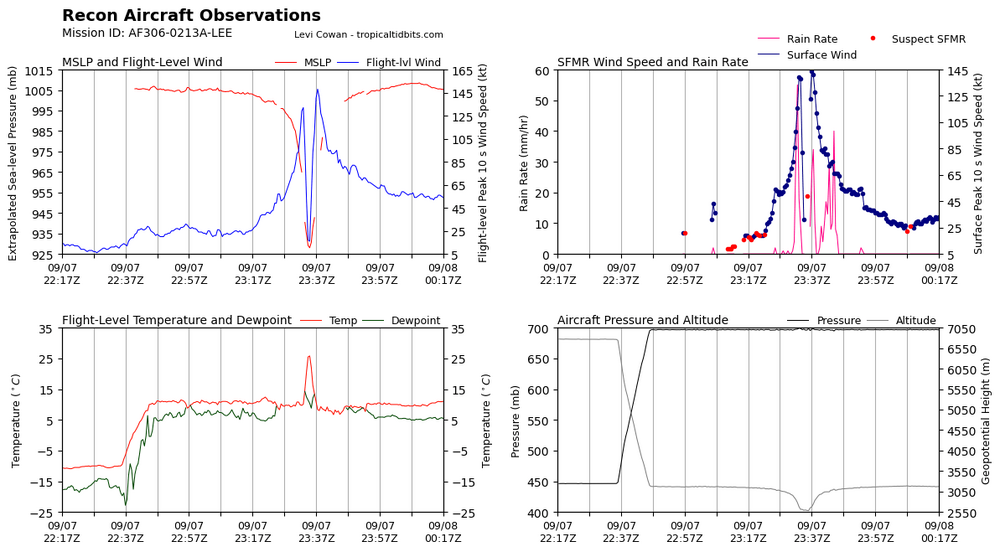
Went from 80 mph to 160mph (give or take) in 15 hours
-
7
-
-
1 minute ago, GaWx said:
Making any mention of a single ensemble member should be punishable by a night in jail or a fine of no less than $5,000

-
1
-
 1
1
-
 6
6
-
-
The TT SST analysis seems to have ocean temps maybe a bit too cool in the cold pool. A buoy in the heart of it is measuring 78.4F which is warm enough to keep a strong hurricane going. It also has risen a full degree since earlier this morning.
-
Not a ton of strengthening overnight, but improvement to structure, should be stable for a while now and ready to rock and roll.

-
Looks like it's about to start it's RI tonight

-
2
-
-
The TT webpage for Lee updated to hurricane, must be upgrading at 5 pm
-
36 minutes ago, wkd said:
Where on tidbits did you find that analysis?
At the bottom of the lower dynamics tab. But it isn't available in all regions.
-
1
-
-
-
22 minutes ago, Windspeed said:
Lee is coming along with haste and will likely be a hurricane sometime overnight into Thursday. Waiting for those CBs to start swinging around the core. Should even see a period of RI on Thursday.

Can see a little shear preventing this thing from wrapping up quicker. Otherwise I'd say hurricane by early this evening , but should at least steadily strengthen until tomorrow when shear should relax, as you say
-
Convection going up big time. Will eventually be what drives the formation of the eyewall barring any unforseen hickups

-
3
-
-
-
A bit of a shift on the GEFS as well


-
1
-
-
5 minutes ago, Intensewind002 said:
If I remember correctly I believe Sam from a couple of years ago was forecast to be a major by 120 hrs on its first advisory but I’m certain it wasn’t 120 kts. Maybe something in the East Pacific had an intensity forecast like this but I’m not entirely sure
Hilary was forecasted at 105 kts on it's first advisory (skipped straight to 35kt TS). Pretty similar in terms of model consensus for a powerful hurricane at this range.
-
1
-
-
Not a lot of steering in the medium range, it's crawling on the Euro at around 150 hrs. May make for a tricky forecast wrt the timing with the trough.
-
4 minutes ago, NJwx85 said:
You would probably get tropical storm force winds all the way back to NYC with that type of track.
Cape Cod would see hurricane force gusts.

Wild to think of all the water that would push into the bay of Fundy
-
I've noticed the GFS has a bias for making hurricanes way too large. Can anyone back that up? Not really going to matter if it stays off shore, but if it does approach the East Coast, it's something to keep in mind as the hype machine gets going.
-
34 minutes ago, WinstonSalemArlington said:
Or not, as it breaks up.
Still, cloud cover making a difference early. Yesterday's GFS had us at 93 at 11 am, it's currently 79.
-
1
-
-
-
-
Will we reach 100 on Friday? NWS doesn't think we quite get there. The EURO, GFS and (long range) HRRR are all above 100, with the GFS hottest at 105. The UKMET, ICON, and NAM are all in the mid to upper 90s. I am inclined to believe the GFS is too hot of course, but reaching 100 remains at least a realistic possibility. Thankfully a relatively dry heat thanks to mountain downsloping, with dew points in the low 60s.


Category Five Hurricane Lee
in Tropical Headquarters
Posted
Structure is impeccable. HAFS B suggests an ERC starting around 21-0Z this evening. Seems inevitable based on the size of the eye. But could see strengthening in the meantime