

olafminesaw
-
Posts
3,060 -
Joined
-
Last visited
Content Type
Profiles
Blogs
Forums
American Weather
Media Demo
Store
Gallery
Posts posted by olafminesaw
-
-
Pretty intense looking MCS rolling towards Jackson MS now.

-
11 minutes ago, wncsnow said:
Yeah this is one of the scariest, craziest Euro runs of all time for my area.... Widespread 10 plus inches of rain up to 25 inches in places. bonkers.
A bullseye of over 20" in 24 hrs NW of Spartanburg

-
Good model agreement on heavy rainfall next week.
.thumb.png.09036f7c7e45bde7380d1ee8fabb97a1.png)
.thumb.png.18a2cb5faa1e0f64e2765b7e08e0a9e8.png)
.thumb.png.789b54c7afe80f41139d0a846aa9dedc.png)
-
 4
4
-
-
I didn't realize how unprecedented tornado outbreaks were in June for Dixie alley. No part of that region has ever gotten a 10% risk (going back to 2006):

-
1
-
 2
2
-
-
Starting to look a little soggy next week with a cutoff low and plenty of moisture

-
7
-
-
Just curious, does anyone know what city is pictured in the NWS haze icon?

-
3 hours ago, GaWx said:
Regarding recorded 6/11-30 W Car/Gulf TC/STC geneses since 1851, 43% (23) of the 54 storms formed during the 53 El Nino years. That's notable considering that only 31% of the 172 seasons (53 of them) since 1851 were associated with El Niño.
Here are the 23 mid to late June recorded TC/STC geneses during El Nino years in either the W Caribbean or Gulf:
1865, 1880, 1887, 1888*, 1899, 1902 (2), 1904, 1913, 1923, 1929, 1939, 1957, 1958, 1965*, 1968 (2), 1972*, 1982*, 1986, 1994, 2006, 2015*
* notes super El Niño years. A whopping 5 of the 7 (71%) super El Niño years had one of these storms! I'm mentioning this because there's a chance that 2023 will reach super status.
This leaves 31 storms that formed during the same period in the same region during 119 non-El Nino seasons or only 26% of them.
In summary, there were 23 mid to late June W Car/Gulf storms during 53 El Nino seasons for a ratio of 43%. This compares to 31 from 119 non-El Nino seasons or a ratio of only 26%. That tells me that whereas we still should take the 12 GFS runs in a row with a W Car/Gulf TCG in week 2 with a grain based on its bias toward that, we should also keep in mind that this year being El Niño means it has a significantly higher chance of occurring vs if it weren't El Niño.
While the GFS is unrealistic in terms of intensity, I'd be a little concerned about a weak tropical system meandering inland and causing flooding. The 12z & 6Z GFS both support this idea, although I kinda expect the GFS to drop the system altogether at some point.
-
1
-
1
-
-
Neat to see the trough highlighted by the smoke on visible

-
1
-
1
-
-
1 hour ago, WinstonSalemArlington said:
Wow! Frisco pier water temp is currently 69 degrees. Average is 76 and lowest in the POR of 1981-2005 is 73 (per surf-fotecast.com)
-
1
-
-
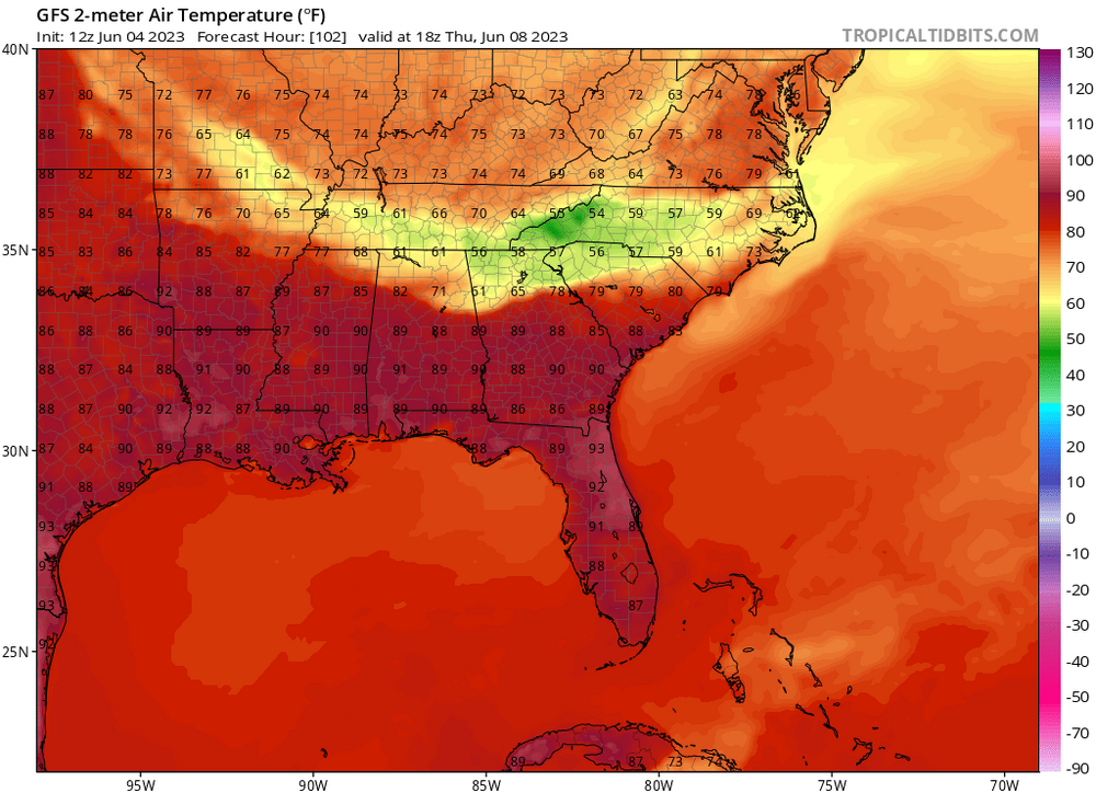
Just a little 26 degree difference between models 3 days out
.thumb.png.788ed02a897656af46b295bcedfa3b3f.png)
-
1
-
 1
1
-
-
Seems a little suspect, could get almost chilly this Thursday
-
4
-
-
If you guessed the following, your entry has a duplicate value with another entry(at least as far as I managed to not fat finger in excel):
11/5/2 (3x), 12/5/2, 13/5/1, 13/5/2, 15/7/3, 16/5/2, 16/7/4
-
1
-
-
1 hour ago, GaWx said:
No upgrade with 11AM EDT advisory even with a SLP drop from 1007 to 1002 mb since the last advisory. 1002 is unusually low for a TD. This is from the NHC discussion:
Convection has persisted throughout the morning, although the
tropical cyclone remains highly asymmetric and poorly organized.
The low-level center is located southwest of the large area of
persistent deep convection. An Air Force Hurricane Hunter aircraft
has found no evidence of intensification this morning, and the
Dvorak satellite intensity estimate continues to support a steady
current intensity of 30 kt for this advisory.
The Hurricane Hunters will continue investigating the system for the
next several hours, and a short-lived increase to tropical storm
intensity cannot be ruled out. However, conditions are expected to
become increasingly unfavorable for intensification later today and
tonight.
With pressure outside the circulation being unusually low, around 1008mb, there's not much of a gradient.
-
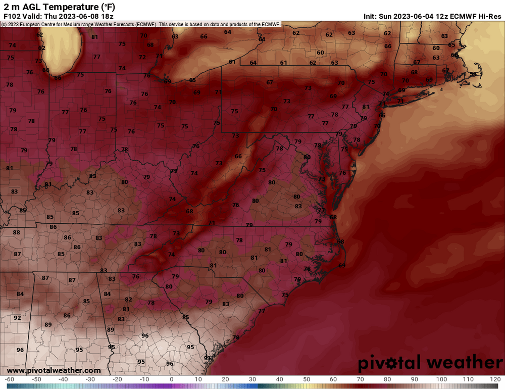
Looks like the warmest it's going to get in Greensboro, in the month of May is 84 degrees (happened to also be 84 in April/March as well weirdly enough.) This is the coolest May by this metric since 1983. Less remarkable in terms of average temp, only a couple degrees below average
-
1
-
-
35 minutes ago, WinstonSalemArlington said:
I am absolutely loving this late spring weather! Curling up beside the fireplace and binging Netflix for Memorial Day is a vibe.
I just want one official forecast discussion to refer to weather conditions as "a vibe", lol
-
1
-
 2
2
-
-
Looks like it's trying to complete the most seamless erc in the history of mab
-
This is from yesterday.
-
1
-
-
-
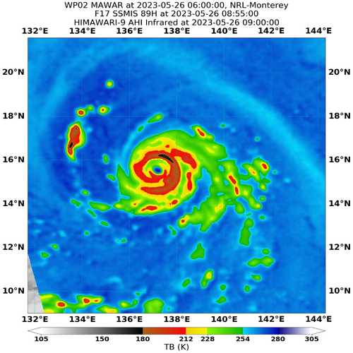
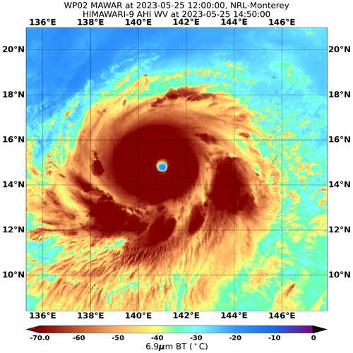
1 hour ago, eyewall said:
Looking more annular in the latest frames

Plenty of banding per microwave. I was thinking that annular cyclones have a somewhat lower intensity ceiling?
-
1
-
-
-
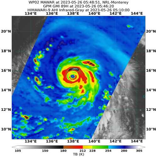
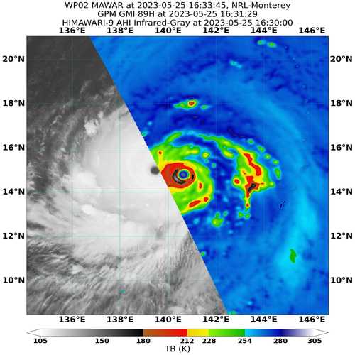
A second RI phase occuring.These, 8 hours apart:


-
1
-
-
4 minutes ago, monadnocks said:
I'm not used to looking at Pacific models so can anyone recommend a reliable one for tracking Mawar? I have a friend in Taiwan atm and am looking to give a bit of guidance.
https://www.weathernerds.org/tc_guidance/storm.html?tcid=WP02
-
5 minutes ago, shaggy said:
It's a race now to see if it finishes the ewrc before reaching Guam.
I think it completed a few hours ago, but it ingested a ton of dry air in the process. This has caused a lopsided eye and a weakness on the north side of the storm. It seem to be starting to mix out the dry air and wrap convection around the eye, as the structure stabilizes. Weakening should at least stop before reaching Guam, and has a chance at re-intensification before landfall.

-
Really starting to look like an EWRC may save Guam from a cat 5 impact. Barring a meld or quick completion, neither of which are especially likely


.png.2d89aa74277b72364320eded610b52ad.png)
.png.a25f19c90c0bc0024a0c042d2a783043.png)
.png.f133a58191c91bdea08551b28b4cee0b.png)


.png.930561454d637468c6c22bd3aa3f6db6.png)


Mid to Long Range Discussion ~ 2023
in Southeastern States
Posted
The GEFS actually ticked north at 12z, but in general the trend has not been our friend. I do think Charlotte and South should get enough rain to mitigate drought concerns. And for them mountains many areas will do well as a result of orographic lift.