

olafminesaw
-
Posts
3,753 -
Joined
-
Last visited
Content Type
Profiles
Blogs
Forums
American Weather
Media Demo
Store
Gallery
Posts posted by olafminesaw
-
-
At least our friends in New England aren't getting it instead

-
 1
1
-
-
-
-
High shifted West this run. Actually better confluence but it's not enough
-
6 minutes ago, LakeNormanStormin said:
I need some pretty colored model runs to look at and obsess over...
For 90% of us it's all about the dopamine hit of the big model run, not the snow itself (insert change my mind meme format here)
-
 3
3
-
-
4 minutes ago, BooneWX said:
First storm is a wash other than some onset ice in CAD regions. I think we all knew it would arrive there eventually - it looked like a miller b from the start. Tough to make those setups work at the front end of the pattern without an anchoring high to the north.
I remain as optimistic as ever about the 8th-12th period. I don’t see any reason to change course on that. Clear signal, just no clear answers, which is fine at a week+.
I agree. If one of us had been in a coma since November and woke up and checked the models, I think they'd be thrilled at what they saw. I do think models backing off from the 8th-12th a bit should give us some pause, but overall the pieces are there to make something happen and that's all we can ask for in a Nina (or near Nina) winter
-
1
-
-
I know the cold had backed off a little on some runs but the GFS is back to something nearly as impressive


-
2
-
 1
1
-
-
48 minutes ago, BornAgain13 said:
Good news on the 18z Euro. It did trend south from 0z. Lines up fairly close to the 18z GFS
On the one hand -NAO should continue to kick south. On the other hand, the last minute North trend is real. I think this map represents kinda the expected outcome with lots of uncertainty north or south. Of course plenty of opportunity for sleet or ZR south of that snow map
-
That axis of WAA snow is going to mean business wherever it sets up.
.thumb.png.e12d1619a77086da7975d0a09a36104c.png)
-
1
-
-
2 minutes ago, TARHEELPROGRAMMER88 said:
GFS may be about to cave to the northern solution? Looks a tad higher and less cold air at 108 hours.
For sure, should still be wintry though. 12z was the outlier even for the GFS anyway

-
-
Much better placement of the high so far on the GFS. Let's see if it still manages to escape to the north

-
1
-
-
Often these front end thump storms over-perform with a few hours of heavy snow to start as warm air advection creates instability. Something to watch if the storm is far enough south and doesn't get sheared.
-
1
-
-
Nice to see the same general look for the 1/10 storm from both the Euro and GFS. Of course the Euro has a great lakes low to keep it from being a much bigger storm
-
1
-
-
Euro AI is really nice for storm #2


-
7
-
-
More at the end of the run. I think we get at least one more shot after the 10th
.thumb.png.f87e025364b85d8b2f1105f965f19b9e.png)
-
3
-
-
18z vs 12z
.thumb.png.25b689009a37abd223ac0efa7261607f.png)
.thumb.png.300a3b29393791dbe3ad331dfe0ff9b6.png)
-
7
-
-
Multiple waves in the Gulf but they all get squashed. I would give it 24 hours before too much concern.
-
 1
1
-
-
Euro's cooking out to 216. Moisture spreading over texas
-
-
3 minutes ago, wncsnow said:
GFS is going to look a little different this run for the first storm
Much further south but also, don't have HP in a good place and big beefy system is going to cut big time regardless
-
ICON looks much like the UKMET for the 6th. Not the storm to bet the house on, a bit of a thread the needle, but while we wait for clarity on the second storm, we track...

-
2
-
-
Best case scenario would be a classic overrunning event on the 6th where it remains more flat/frontal. Only downside is someone probably ends up with a lot of ZR. The the coastal comes in a few days later and buries us. My sense though, is that a cutter for the first storm may be a better way to set the stage for the second, where without it cutting there's a chance of more of a threat to the deep south than the Carolina's. Could be wrong though.
-
4
-
-
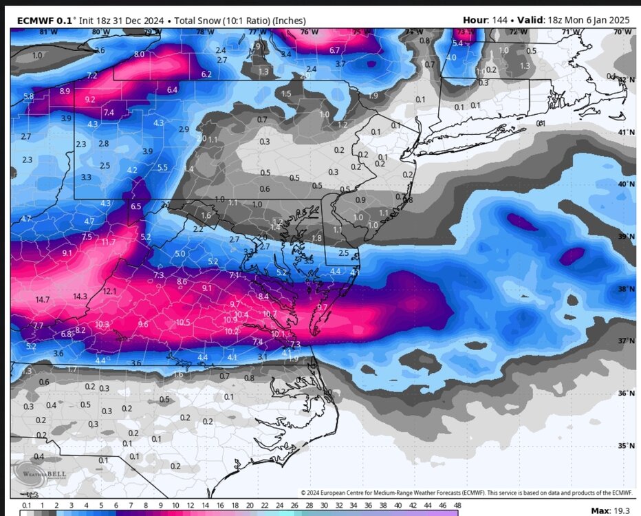
FWIW, the UKMet looks really nice for the storm on the 6th

-
3
-


.png.a31a94c278751ebdbcaf5a10d4322299.png)


.jpeg.9986126786119c00acca1b078082ffc3.jpeg)


.png.9b80b624bd98ed6b9874f9d5e8670144.png)
.png.51b6f85fd0163777b2eb722025410923.png)
.png.236999250f746180a0b7c933faf39706.png)


Mid to long range discussion- 2025
in Southeastern States
Posted
Not the worst