

olafminesaw
-
Posts
3,060 -
Joined
-
Last visited
Content Type
Profiles
Blogs
Forums
American Weather
Media Demo
Store
Gallery
Posts posted by olafminesaw
-
-
Convection wrapped fully around the eye the past couple frames. Could easily be a major by 8pm
-
 1
1
-
-
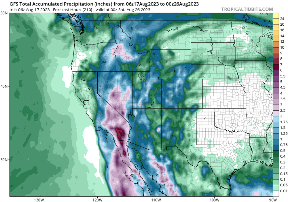
The Salton sea averages 5-6 inches of rain per year and the saline body of water is highly toxic. Honestly not sure what a years worth of rain in 48 hours will do.
-
1
-
-
11 minutes ago, Boston Bulldog said:
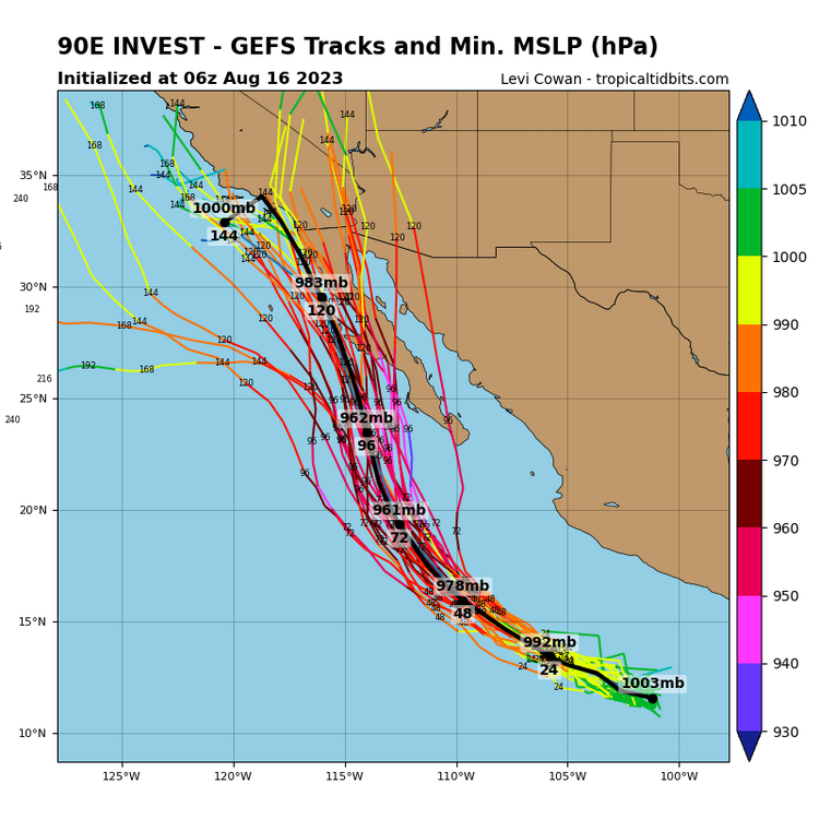
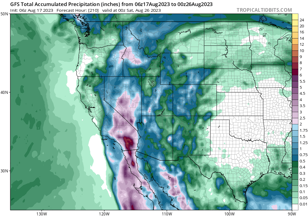
Some pretty remarkable Integrated Water Vapor Transport values associated with the modeling for our future system. Regardless of SLP track, the San Gabriels should get good drink. Primary concern would be mudslides if these depictions verify
Kathleen (1976)is a very good analog. Described as a 1 in 160 year event
https://en.m.wikipedia.org/wiki/Hurricane_Kathleen
-
Pretty unbelievable honestly. I can't imagine more than a weak TS by the time it reaches CA, but could be a significant flood threat
-
TFW the first TS landfall in the US this season could be San Diego.

-
5 hours ago, eyewall said:
There could be the MCS in the morning and then the main round of severe in the afternoon/evening. MHX discussion is quite bullish.
Current CAMs seem to suggest the morning MCS will be the main event (strong to borderline severe storms), with some scattered strong storms behind it. Usually these large MCS systems do put a damper on several storms later in the day, even if they clear out by mid morning.
-
2
-
-
40 minutes ago, eyewall said:
Don't sleep on tomorrow either. Could be another unusually strong severe event for this time of year.
Seems like timing is the big question. May move through too early in the day. Parameters aren't as impressive either way, but a nice line of storms regardless.
-
-
Bumpass has a good view
Hehe

-
 2
2
-
-
-
14 minutes ago, kvegas-wx said:
Never like being the center of attention when it comes to tornado watches and clown maps...unless they are snow maps!
Yeah, for sure. While I love me some severe storms, it's a fine line between a good show and property damage, insurance claims, or worse. My gut is this will be a pretty classic widespread strong/severe wind outbreak, but nothing high end and not much in the way of tornadoes.
-
First 45% wind prob for RAH since Oct 2019, first Moderate risk for Blacksburg WFO since April 2019. I think this one deserves a thread!

-
2
-
 1
1
-
-
Enhanced risk for most tommorow, primarily wind driven. Since the enhanced category was introduced in 2015, RAH hasn't been under one during the month of August
.thumb.png.9d73cbf55c5ed9f812ba20853005c87f.png)
-
1
-
-
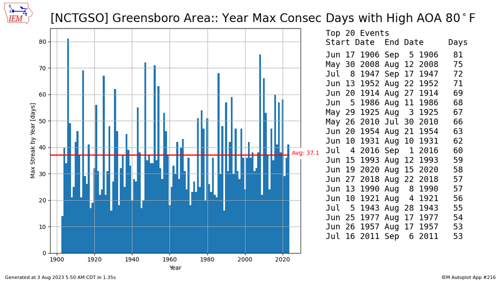
Although it's disappointing that the mountains will prevent more significant rainfall today, it's nice to see a forecast high in the 70s. This brings to an end a 42 day streak of highs at 80 or higher, which is fairly close to the average for the longest stretch of the year
-
3
-
-
10 minutes ago, TheDreamTraveler said:
That's something I forgot to even take into account. Those waters on the coast have saved NYC and New England from many a powerful hurricane. The only hurricanes that were able to cause massive damage were the ones that were barreling north so impossibly fast that the lag period of the storm weakening from being over the cooler waters would occur too late due to forward speed. And now we're getting to a point where you won't even need them to be barreling at high speeds for them to retain a lot of their overall strength
True, although water temps still certainly a limiting factor, even with such crazy anomalies.

-
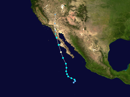
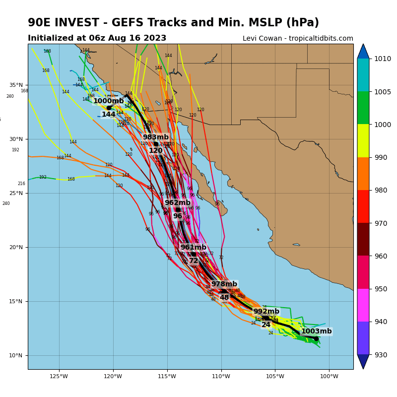
I'm just imagining NHC trying to make a cone for this one...

-
3 hours ago, eyewall said:
Yeah this is the time of year I hate most.
On the plus side, we are now more than halfway through the hottest 90 days of the year.
Also...a slow decline towards the winter solstice.
-
1
-
-
It did some restructuring and now it has a double eyewall that it will likely maintain through landfall. Pretty neat stuff!


-
3
-
-
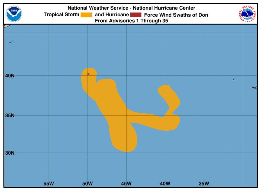
I nominate this one for strangest looking cyclone of the year

-
1
-
-
A work of art this one.
-
4
-
1
-
-
1 hour ago, wncsnow said:
F3 tornadoes in NC in July have to be really rare right? And probably even more so without a tropical system.
https://mrcc.purdue.edu/gismaps/cntytorn#
Seems to be the first time (unless maybe that fishy looking one right on the border)
-
From the live stream survey cam

-
-
4 minutes ago, NorthHillsWx said:
WRAL said there are reports of injuries coming out now. Hope everyone was OK. That looked very bad with the debris ball holding together so long.
Fortunately it mostly passed through farmland. Brattleboro (population ~500) may have taken a direct hit though.


.png.128d80269d94b4632fecf0ea0251f58c.png)


Hurricane Hilary
in Tropical Headquarters
Posted
ERC well underway. Seems to be going rather smoothly.