

olafminesaw
-
Posts
3,052 -
Joined
-
Last visited
Content Type
Profiles
Blogs
Forums
American Weather
Media Demo
Store
Gallery
Posts posted by olafminesaw
-
-
Ok so far we've got Euro and NAM in the amped camp; GFS, icon and RGEM in the suppressed camp, and UKMET and CMC somewhere in between
-
 1
1
-
-
The 12z GFS will be huge. Whichever direction it moves will be a big indicator of which way things are trending. I will say, I wouldn't worry too much about one run of the Euro. If nothing else, it largely rules out the possibility of over-amplification.
-
2
-
-
4 minutes ago, Cheeznado said:
DT won't like the 06Z EC and EPS- pretty big change for the worse for many folks. Much more towards the GFS. Yes, the GFS has sucked recently but with this storm it has been pretty consistent having a suppressed system with maybe only a very narrow band of freezing/frozen precip on the northern fringe. This could still change but time is running out. 12Z runs may tell the story.
Certainly bad news for central VA. However, the GFS has taken big steps towards more amped, so I think the I-85 corridor is looking good for now
-
1
-
-
She's a beaut (GSO)

-
2
-
-
2 minutes ago, burrel2 said:
06z Euro for the first time in a while actually ticked towards less phasing with the southern stream. Helps thermal profiles for places like raleigh, but hurts precip totals to the west. It has me getting .25 liquid(maybe a little more to come past hour 90). The 00z run had me at .65 liquid.
Yeah, I've definitely noticed this on the less amped solutions. Could end up as a SE VA special, depending on the timing of the phase.
-
1
-
-
-
37 minutes ago, wncsnow said:
The warm nose actually underperformed in most areas and there was more sleet than ZR.
At the same time, we saw models bit by bit, speed up the timing of the changeover to sleet. Of course this had mostly go do with the storm slowing down and the ULL cutting west of the Apps. I do think in general, the models had a reasonable grasp on the temp profiles in the end. Point is, I think most of the time outcomes have more to do with the track of the low, strength of the high, etc. than bad physics of the model
-
1
-
-
-
Ice for many. Still, very long duration

-
2
-
-
Just keeps reloading
-
3
-
-
-
1 minute ago, ILMRoss said:
That northern stream short wave on this run is worst its looked (weaker and ticking NE) so far.
Looks like it's developing something in the gulf for the weekend though
-
1
-
-
2 minutes ago, burrel2 said:
Good if you're worried about suppression and a weak/non-event for most.
Though the way things are trending I think i'm more concerned this thing winds up being too amped. The good thing is we're only 96hrs away so how much more drastically could it trend?
Yeah, a big advantage to these type of setups is it's pretty easy to score a light to moderate snow event. A big hit, however is a bit more of a thread the needle scenerio. If a lp system develops along the boundary and deepens, it can bring in warm mid level air and cause mixing issues along the southern fringes. There is a fairly narrow jackpot zone, and the northern fringe struggles with dry air, but gets nice cold powder
-
4 minutes ago, Beach Snow said:
Icon didn’t do terrible for the past storm its been showing the signal over the last few days
Yeah, just really jumped all over the place. Showed the range of outcomes which was helpful I think.
-
The icon looks good for a long duration moderate event for the climo favored regions of the central NC Piedmont (the Icon is trash I know, but better than discussing, well... not weather)
-
2
-
 1
1
-
-
Considering how the GFS ensembles have a tendency not to vary too much from the op, it's encouraging to see a bunch of members with decent hits
-
 1
1
-
-
4 minutes ago, Dunkman said:
I can’t believe how much sleet we have. It’s been pouring sleet for hours and hours. Hopefully we miss out on most of the ZR?
Yeah, probably just a light glaze once we get into the dry slot
-
1
-
-
What a sounding. Classic sleet storm in the Triad. Going to take ages to melt this glacier
.thumb.gif.eca63ff3accd7263a9fa78d602e351aa.gif)
-
3
-
-
A bit of a dry slot for western NC. Somewhat expected given the eastward progression of the low, but a rather stark cutoff

-
1 minute ago, kvegas-wx said:
Still like a frozen downpour in July here in the heart of the Triad. Absolutely pouring sleet.
It's crazy how big some of the pellets are too. Nearly pea sized
-
4
-
-
As expected, p-type maps are not to be trusted. The majority of the freezing rain zone is falling as sleet

-
2
-
-
1 minute ago, PantherJustin said:

Wow, that's the most bullish I've ever seen them at this range
-
1
-
-
5 minutes ago, Dunkman said:
Some weird reports but I see no evidence of anything but sleet here in High Point right now.
Yeah...it seems kgso hasn't been reporting sleet. It's like their ip key is broken or something, lol
-
15 minutes ago, ILMRoss said:
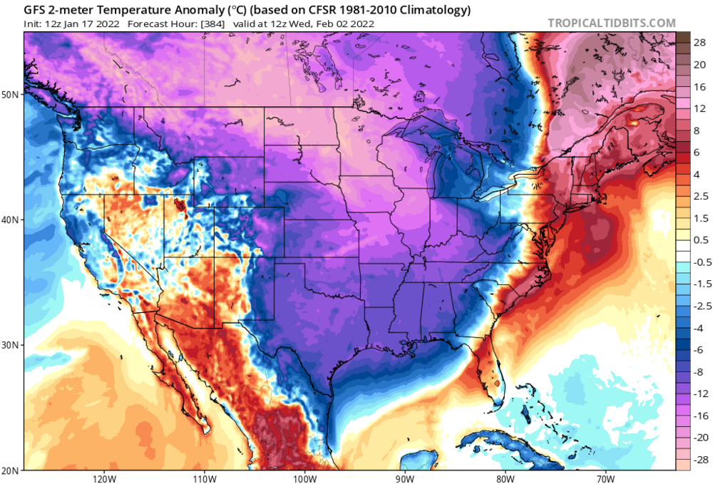
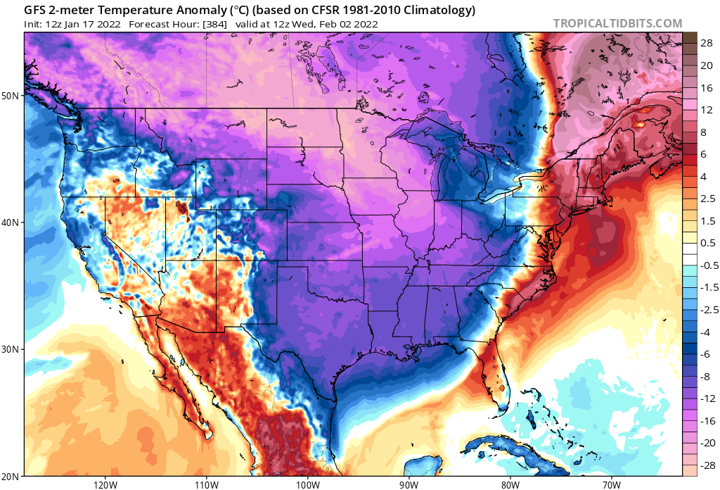
I think you have a weird mix of emotions on here. A little bit of "here we go again", a little bit of "most focus is going to the situation at hand", etc. But to balance my pop cultural reference I will say this: On a wholesale level this potential looks much more fruitful than our current storm. Temperatures are leagues better. Huge, consistently modeled cold push. The smart folks at Wilmington's weather office have already put in snow in their forecasts. That almost never happens. I think that just about every office around here already introducing snow for next weekend is a pretty big sign. The National Weather Service is generally the largest brain trust of meteorological knowledge that we have and it's both rare and awesome to see them biting this far out.
Since we're immediately following a storm that had a ton of potential that backslid into Miller B mush as we got closer, I think feeling snakebitten and being a little reticent to buy into this is understandable. But make no mistake- I'm feeling pretty excited now that I've digested things. Hoping that the 12z suite is positive after I've left such a gushing review of the potentia
I appreciate your insight. Definitely just kidding around here. Hard to get excited about something 6 days away when it's currently snowing outside, but wow, who thought we'd get such a stellar pattern out of this winter

.png.a45db917ac918555a5f3255c5b464ed8.png)
.png.dfd426289b333342e3b0a7b2abf5a5ee.png)

.png.9ef0f83603d4d90f1e80a446c9c465fe.png)

.gif.58cb73aeb656669210c9fc3ecc8d25fe.gif)

January 20-22 “bring the mojo” winter storm threat
in Southeastern States
Posted
Seems like Rocky Mount may end up doing better than the Triad. I have a feeling that although we will have long duration and less mixing issues, dry air may reduce the max potential from playing out