

olafminesaw
-
Posts
3,755 -
Joined
-
Last visited
Content Type
Profiles
Blogs
Forums
American Weather
Media Demo
Store
Gallery
Posts posted by olafminesaw
-
-
11 minutes ago, GaWx said:
The GFS suite the last few runs has continued to say "What cold? The suite had for days been showing a cold shot (30s lows much of the SE) for 4/12-13. Now that period on it is near normal at the coldest.
And we're at that sweet spot in the year where slightly below and slightly above average are fantastic, and well above or below are tolerable (barring a wedgy drizzle-fest)
-
11 minutes ago, cgidd8 said:
That occlusion to regeneration quickness on the Tennessee cell was wild. I don't think I've ever seen anything like that.
The whole evolution of this supercell has been wild. Could be studied for years.
-
What a beadt
2 minutes ago, kayman said:Both tornadoes are headed toward the north side of the metro Memphis area
Actually a pretty rural area, some small towns, but shouldn't run into anything major for a while, other than the interstate
-
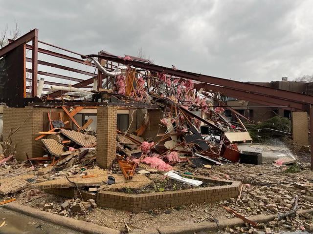
Office building in Little Rock, per reddit.
-
6 minutes ago, WestMichigan said:
At 1155 AM CDT, a severe thunderstorm was located near Brunswick, or 9 miles north of Slater, moving northeast at 70 mph.
These storms are moving fast. Going to make chasing rather challenging for those who go out.My understanding is that fast storm motion can inhibit tornado formation as the updraft is continually being disrupted. If my memory serves anything over about 50 mph is when this starts coming into play. Just something to watch, but there are certainly exceptions to this rule, as fast moving tornadoes are definitely a thing.
-
 1
1
-
-
Wild to see a PDS tornado watch touching a WWA, and one county removed from a WSW
-
4
-
-
-
9 minutes ago, WXMan42711 said:
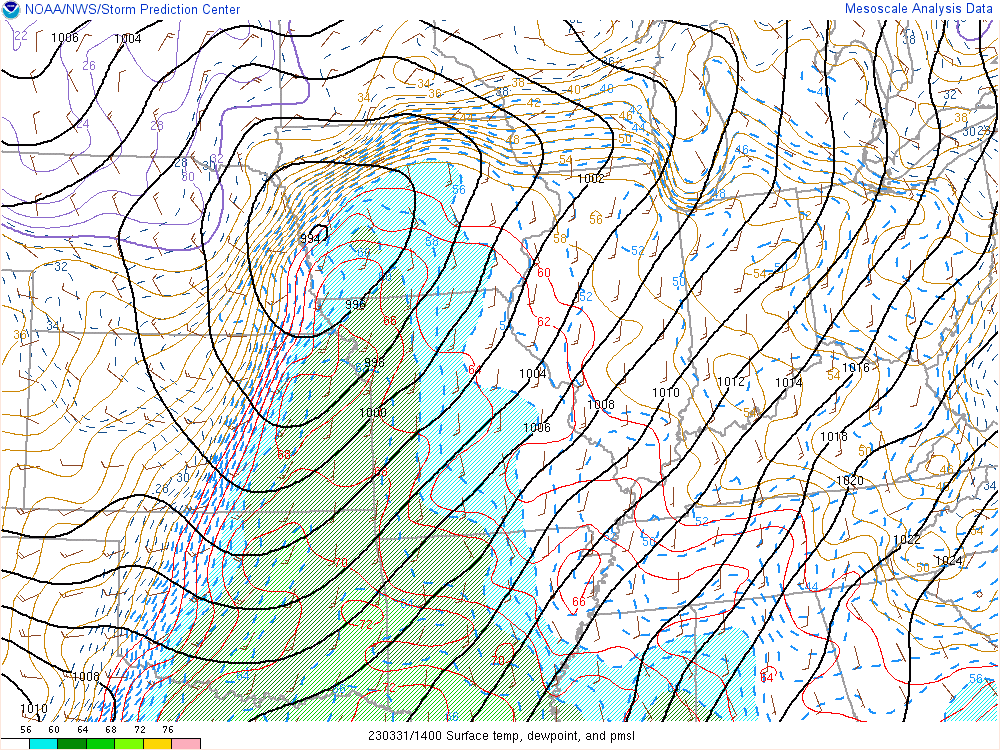
 Mesoscale Discussion 0390
   NWS Storm Prediction Center Norman OK
   1037 AM CDT Fri Mar 31 2023

   Areas affected...portions of southeastern Iowa...northwestern
   Illinois...and far northeastern Missouri

   Concerning...Outlook upgrade

   Valid 311537Z - 311630Z

   SUMMARY...Portions of the Moderate Risk over southeastern IA,
   northwestern IL, and far northeastern MO will be upgraded to a
   categorical High Risk in the 1630 UTC Convective outlook.

   DISCUSSION...An upgrade to a tornado-driven High Risk (30%
   probability) is expected for the 1630 UTC outlook. Environmental
   conditions are quickly becoming favorable to support the potential
   for numerous strong to potentially violent and long-track tornadoes
   across portions of southeastern IA, northwestern IL, and far
   northeastern MO. Please see the forthcoming Day 1 outlook update for
   more information.

   ..Lyons/Smith.. 03/31/2023
The only other time a tor driven high risk was issued for that region was also in March. Does anyone know what date that was? I don't know my severe weather history all that well.
-
-
It seems that SPC has to be at least considering a high risk, the biggest argument against being uncertainty regarding the location of the highest threat area. The only question that remains is to what extent/how long, will cells remain discrete
-
4 minutes ago, yoda said:
Where is that from?
-
 1
1
-
-
-
8 minutes ago, HillsdaleMIWeather said:
Major expansion of the moderate risk on the new outlook
About doubled, both in terms of population and area. Also the Enhanced pushed well East all the way to Ohio.
These threats that effect large areas with the mod/enh tend to be a bigger deal than a small high risk.
-
1
-
-
30 minutes ago, Chicago Storm said:
Each region has always had their own threads, so doesn’t matter much in the end.
.I wish the mods could merge the threads from each sub, so it linked to the same place. Really mostly just applies to severe, but it's super annoying to keep up with two threads at once.
-
2
-
-
3 hours ago, southmdwatcher said:
SPC has upgraded central Louisiana, central and southern Mississippi and Alabama to a moderate risk for tornadoes and hail for today and tonight.
That escalated quickly!
-
47 degrees and no need for a jacket, with a light breeze and that warm march sun!
-
2 hours ago, NorthHillsWx said:
I love the annual morality debate between those wanting it to be warm and those wanting to hang onto cold in spring
Before DST root for cold in case of snow. Then root for warmth until Mother's day when we root for cooler than average temps until Halloween.
-
5
-
-
14 minutes ago, PackGrad05 said:
Crazy how much the GFS changed. Tons of rain for NC to absolutely nothing. It'll keep wobbling.
Yep, suppressed and energy held back. Definitely a possibility and more of a fear for me at this point than a cutter.
-
1
-
-
8 minutes ago, eyewall said:
When I lived in VT, the big ones were almost always in March. I took these in 2017 on 3/14 and 3/15:


That last one looks fake. Like a zoomed in photo of one of those mini Christmas villages.
-
1
-
-
Even WPC is highlighting a d7 threat for the mountains

-
2
-
-
Overnight models looking surprisingly good for the lowlands. We may close in on a solution a little quicker this time around (for better or for worse) with a less progressive flow.
.thumb.png.9608c317e3eacaa16a163c3fba41e926.png)
-
1
-
2
-
-
Although the OP was a dud (more euro-like) the ensembles are the best yet.

-
53 minutes ago, Tyler Penland said:
All I had to do was fly out to Portland and suddenly winter decides to actually produce.

Sent from my SM-S911U using Tapatalk
You simply flew to the wrong Portland!
-
Fairly good signal for the mountains. Also a cluster of members that stay suppressed.
.thumb.png.3eab872a841208c183c49873791e206f.png)


.png.b131e4331d82e2271ffc48e52878bba9.png)

.png.00f7a04e328732dc90e736c6ec8a2131.png)
Mid to Long Range Discussion ~ 2023
in Southeastern States
Posted
At least now Easter Sunday high pressure is starting to move in, so should be clearing up throughout the day