

olafminesaw
-
Posts
3,060 -
Joined
-
Last visited
Content Type
Profiles
Blogs
Forums
American Weather
Media Demo
Store
Gallery
Posts posted by olafminesaw
-
-
23 minutes ago, Sandstorm94 said:
Surprised nobody made a thread, max forecasted winds expected to peak at 70mph. This one really came out of nowhere...
Sent from my SM-S102DL using Tapatalk
Fish storms have unrealistic beauty standards
-
10 minutes ago, Eskimo Joe said:
You must be new here.
Fair. The meltdowns will be glorious when the core falls apart over Cuba and makes landfall over the swamps of Florida as an anemic cat 2. Or something like that
-
 1
1
-
 2
2
-
-
4 minutes ago, hawkeye_wx said:
Saturday, south of Jamaica, is when the latest Euro begins to ramp up the cyclone.
I foresee a lot of low-sleep nights coming up next week as I have to stay awake for one more recon pass or model run.
Yeah, it's wild how much the hype train has ramped up being 10+ days from a US landfall. I have a feeling the latest Euro won't help either...
-
1
-
-
6 minutes ago, Newman said:
I was apart of a research group on Sable Island this summer, so it holds a very special place in my heart. If you don't know where Sable Island is, it's that small crescent Island south of Nova Scotia about 200 miles off the coast.
I can't imagine what the scene will be on that island this coming Saturday. They've seen quite their fair share of storms, but this will be truly special. If I had to place a Webcam anywhere, it would be there. The surge could be unheard of. Wind is less of an issue due to minimal infrastructure and blowing of debris. But I am super interested to see how this plays out for Sable and mainland Nova Scotia
Thanks for sharing, I was just researching the island this morning, noticed the speck on the NHC map. There actually is a webcam on the island:
-
1
-
-
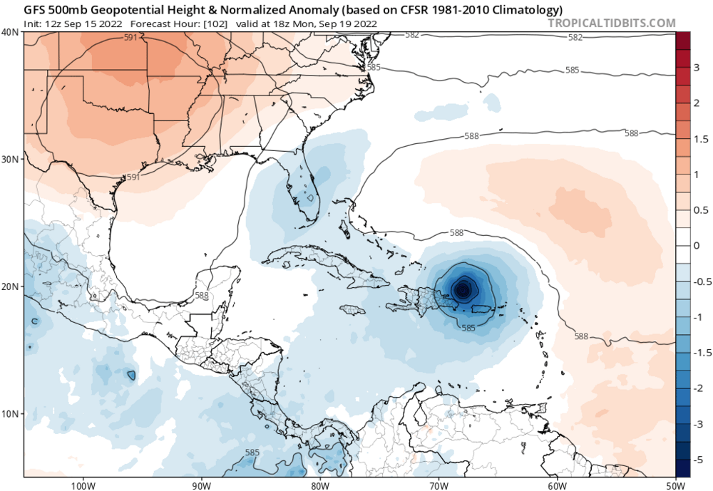
One thing I'm noticing is just how massive the models are making this by the time it enters the gulf. Evokes A certain K storm
-
Also, I believe this is the first recorded case of a major hurricane making landfall on grand turk
-
1
-
 1
1
-
-
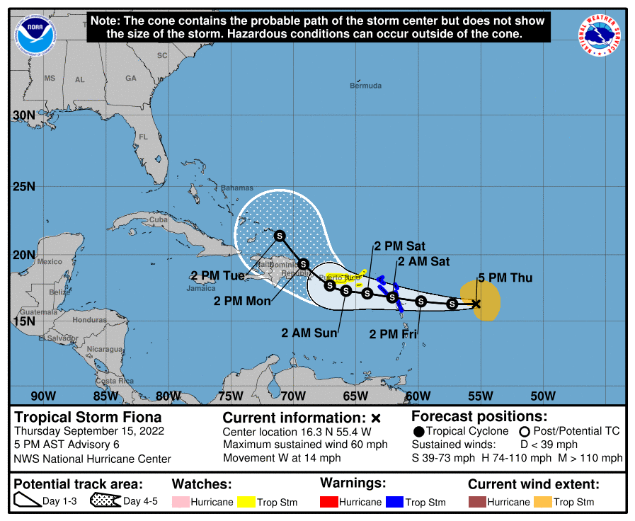
The NHC's five day forecast up to this point was near perfect for track
-
2
-
-
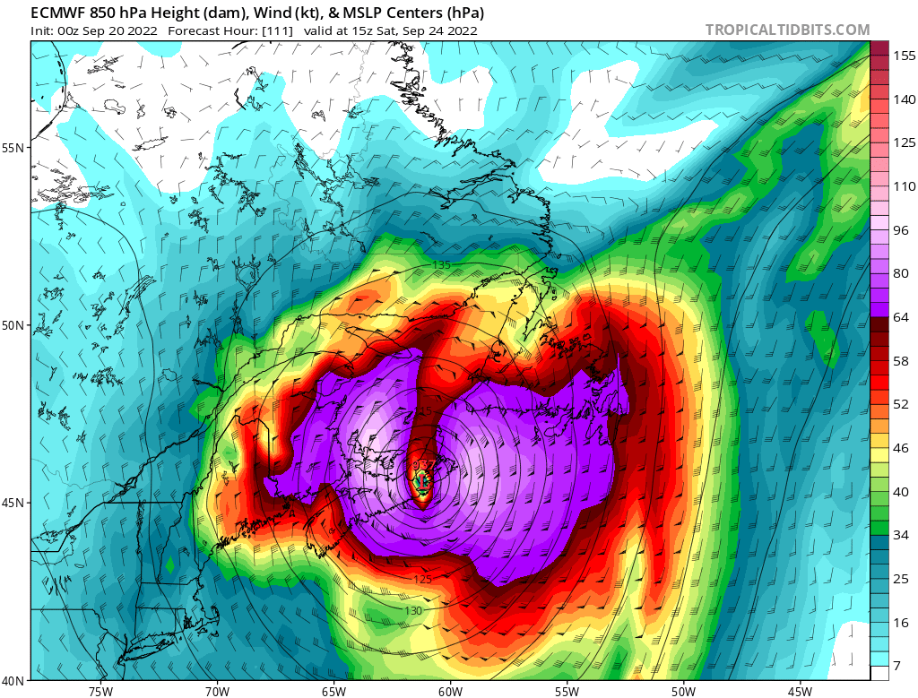
940 mb is the Canadian LP record

-
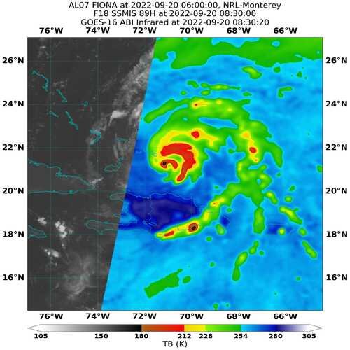
A bit lopsided on microwave and ragged on satellite this morning. Seems like it keeps trying to do an EWRC, but is slow to do so
-
1
-
-
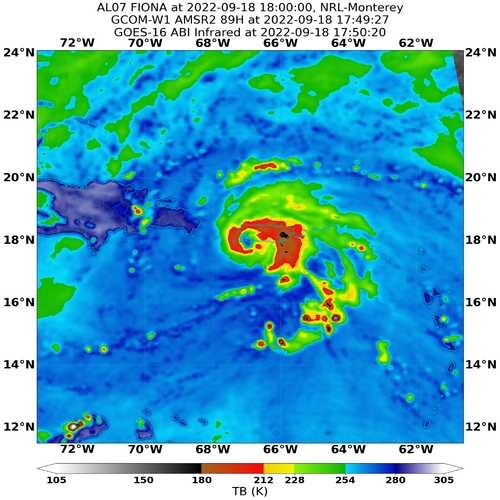
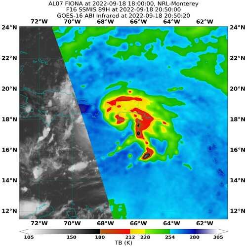
Structure perhaps degrading a bit over the past few hrs fwiw.
-
 1
1
-
-
32 minutes ago, Sandstorm94 said:
Still got that slug of dry air to deal with but that eyewall is rapidly getting it's act together

Sent from my SM-S102DL using Tapatalk
Seems like a situation where land interaction actually helps to push out dry air and tighten the circulation. It may or may not be over land long enough to impede strengthening
-
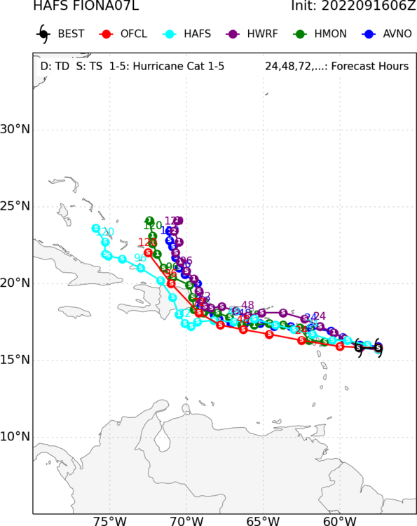
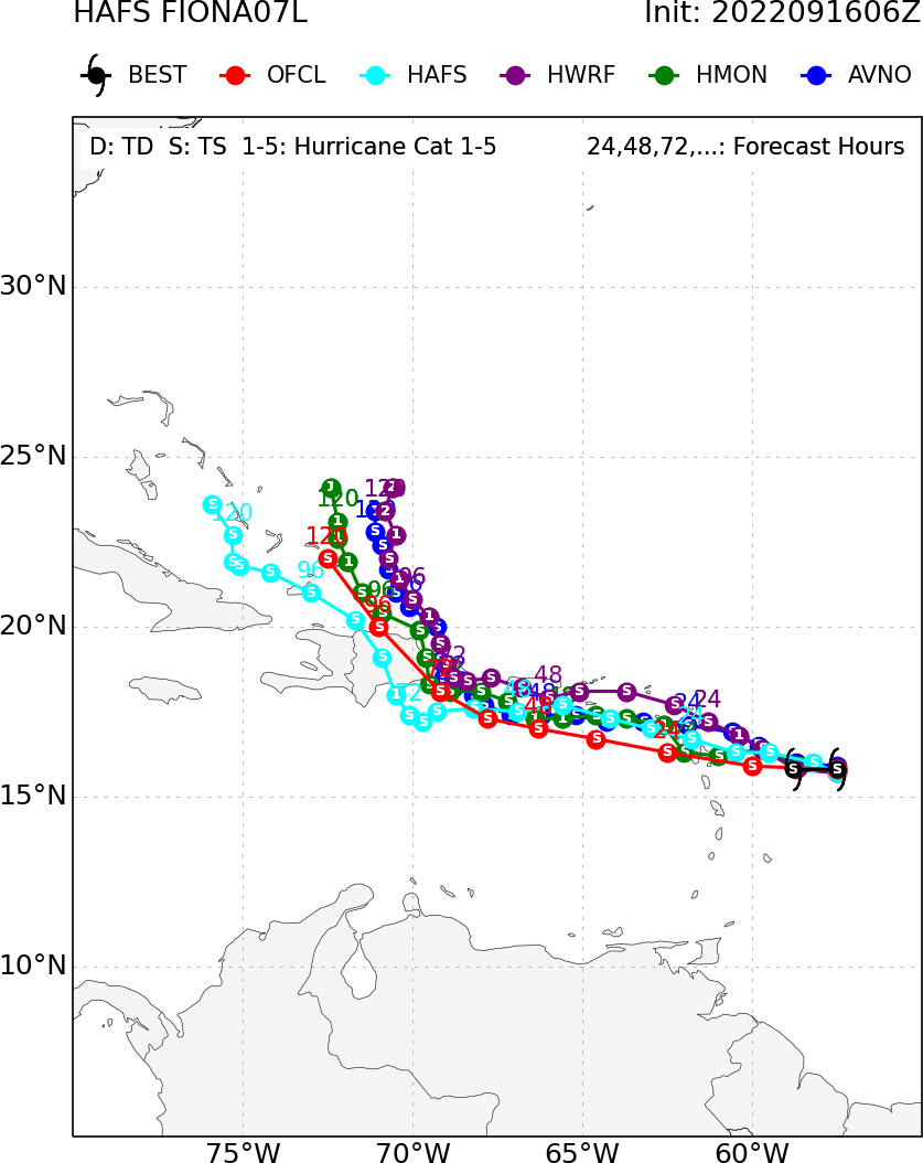
HAFS, which seems to be performing well so far, brings Fiona through the middle of the Bahamas
-
1
-
-
Overnight models seem to be converging on a recurve/surf-maker. Still, wouldn't rule anything out until it's made it through the islands.
.thumb.png.1bcad85222b62b99aa023c22c1ba9942.png)
-
1
-
-
12 ensembles comparison

-
1
-
1
-
-
31 minutes ago, MJO812 said:
Eps looks to recurve earlier than the op
Yes but the members that keep it weak also are the ones threatening the coast. I honestly think at this point a slow death in the Caribbean is more likely than a recurve. But if it can survive past the islands who knows, as conditions are likely to improve

-
3
-
-
The Euro is crawling. makes landfall in West Palm Beach in 9 days as a moderate TS
-
2
-
-
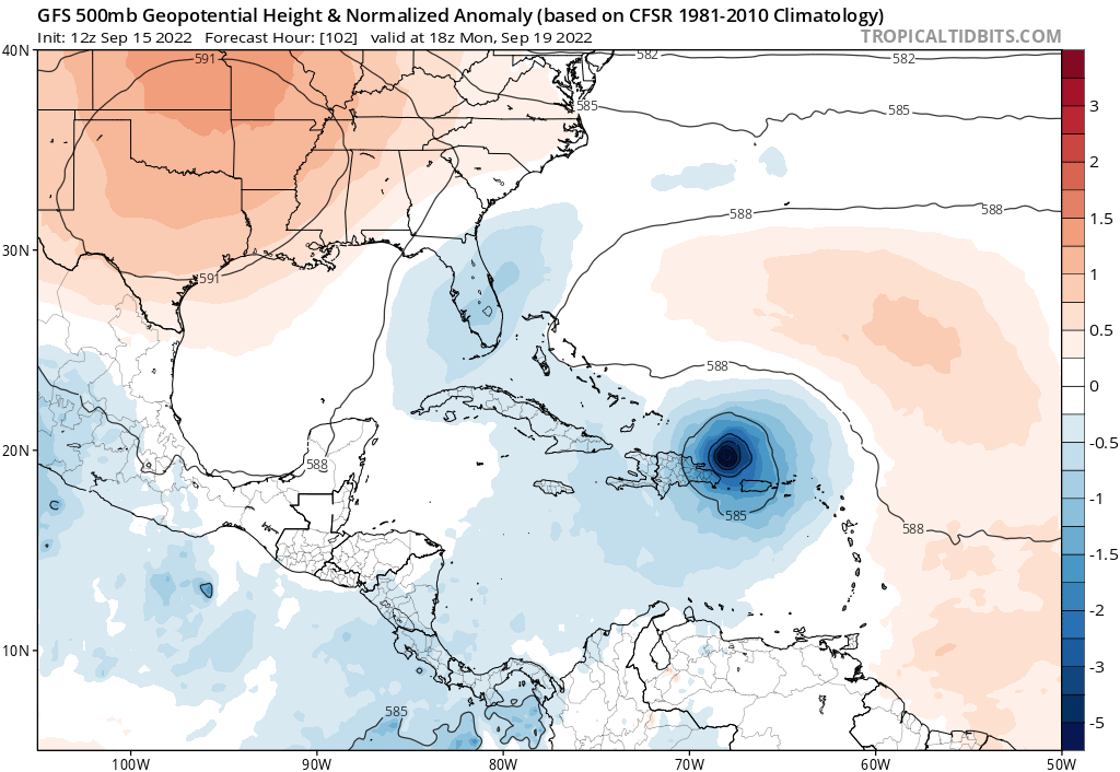
In the upper levels the Euro seems to have taken a step towards the Canadian with the ridging shifting east and closing the escape route. Keeps it really weak though and seems to make a broad messy system that may have a hard time organizing
-
Bye bye LLC

-
GFS is further south. Also, curious how that feature over Florida will end up coming into play
-
5 minutes ago, WxWatcher007 said:
As @Superstorm93 posts above, the ensembles still take it over the island, so I think that’s a likely outcome. I was just posting the low positions by comparison. I should have been clearer.
Yeah, his does make it clearer the tracks they end up taking. I just thought it was funny how even though the mean would be over the island, all the individual members appeared to miss in yours
-
Just now, WxWatcher007 said:
I think it still ends up north of the island. Here are the EPS lows by comparison. I’m sure this’ll bounce around.
00z EPS

06z EPS

Island forcefield, lol
-
Quite a convective burst in the last hour or so. Impressive for nearing Dmin. Doesn't really look like it's occurring over or near the center, but I don't have that expertise
-
With a track like that, a weak system is almost more likely to hold together over terrain than a hurricane.
-
2
-
-
I believe it has been 5 full days since the NHC gave this a 70% chance of development through day 5. I feel like this has to be approaching longest lived cherry and it may never develope
-
2
-
.png.0b55dd1ceed18ef5e30ce1a7eca0dfc6.png)


Hurricane Ian
in Tropical Headquarters
Posted
That really is the norm for landfalling gulf storms. Particularly in October