

olafminesaw
-
Posts
3,754 -
Joined
-
Last visited
Content Type
Profiles
Blogs
Forums
American Weather
Media Demo
Store
Gallery
Posts posted by olafminesaw
-
-
Seems to be a big of low level subsidence that is inhibiting the development of heavier precip across the triad. We may end up underperforming unless we can get some better lift.
-
 1
1
-
-
4 minutes ago, Amped said:
Lots of Tornado warnings in central NY and Nrn Pa
Already the 2nd most tornado warnings in a single day for the state at 22 per IEM. 5/31 1998 was the highest single day record with 41
-
YTD heat index values confirm that this has been an unusually warm start to summer.

-
48 minutes ago, cptcatz said:
I get the hyperactive season with big hurricanes in ASO but I just don't see how we get to 25 named storms with 3 in the books and a dead July on the horizon. Going into August, 2005 had 7 named storms and 2020 had 9. To get those big named storm numbers, you need a lot of June/July slop.
I would not be surprised to see several hurricanes in the second half of October/November. The highly anomalous SST's should extend the window of opportunity by at least a couple weeks.
-
4
-
-
2 minutes ago, hawkeye_wx said:
This is one of those, "If it could have acquired its current level of organization yesterday morning...", situations. Fortunately, for the Texas coast, Beryl will run out of time before it can do anything crazy.
Geography dictates that almost any system coming into the Gulf is going to have question marks, such as whether a core can rebuild after being shredded by land, limited time over warm water to strengthen before landfall, shear and dry air from troughs coming off the mainland. There's a reason major hurricane landfalls in the Gulf are relatively rare despite the consistently favorable SSTs
-
 2
2
-
-
39 minutes ago, WxWatcher007 said:
First extrapolated pressure of 988.3mb
Still need a dropsonde to have the official pressure.
Edit: adding the latest microwave image

Big eye. Might take longer to tighten up/ deepen.
-
1
-
-
16 minutes ago, hawkeye_wx said:
The 12z GFS has Beryl becoming so broad and disorganized that it is only able to get itself together at the very last minute.
This happens a lot, where the only way for the core to tighten after becoming disorganized is frictional effect in the few hours before landfall
-
Treasure beach and surrounding areas may get hit the hardest, a big blowup of convection in that area, and some potential to take a step north.
-
1
-
-
Good news for Jamaica on the 8am track, it keeps the center well of shore, would probably only push hurricane force winds to the coast and Kingston may have dodged a bullet from a wind/surge perspective. Still, the island will bear the brunt of the heavy rain
-
Bizarre looking, never seen such a sheared looking hurricane with such a healthy looking core

-
Euro drops up to 10" of rain in a 6 hr period. Considering globals tend to under estimate both localized higher totals as well as terrain enhancement, could definitely be some serious flooding/ mudslides. A big mitigating factor is the very quick forward motion. Most of the rain falls in 6-8 hours.
-
14 minutes ago, MN Transplant said:
Catastrophic for where, though? Take a look at Google Maps for Jamaica. There doesn’t seem to be many places that would be significantly impacted by a surge from an E to W moving storm.
I would think the hurricane would funnel water into the Kingston harbor, but I'm not seeing much historically to support this possibility. Dean took a similar track/ intensity and I'm not seeing any record of significant surge. It may be protected by coral reefs and is sheltered by a barrier island so that may be why. And as you say a storm track parallel to the coast is going to push less water than more of a 90 degree angle (not sure if I have that right, someone more knowledgeable can correct me)
-
I know we normally say an ERC means higher impact, but with increasing shear it could be a saving grace for Jamaica. Sometimes hurricanes can unravel mighty quick if an ERC occurs in a sheared environment

-
3
-
-
Could be a really bad track for pushing surge into Kingston
-
10 minutes ago, gymengineer said:
I think we have to wait for more information because, as shown in the graphic Chinook posted, the METAR with the 105 kt gust came from TGPY- Maurice Bishop International Airport.
I agree, especially since there doesn't seem to be any reporting stations on the small islands that got hit the hardest. FWIW The latest METAR on windy.com says gusts to 67kts 2 hrs ago and 59kts 1 hr ago. Makes way more sense.
-
7 minutes ago, WxWatcher007 said:
I feel pretty certain that is a faulty anemometer. FL winds in that area only would support near hurricane force winds.

-
2
-
-
3 minutes ago, NorthHillsWx said:
IMO there’s evidence this is already at cat 5. Radar, flight data, and satellite could all be used to say this is a 5. It’d close. I don’t think it’s done deepening yet either. 150 or 160, not terribly much difference. At least it missed the larger islands, those islands it did hit are likely shredded and will be uninhabitable after the storm for a long period. I hope everyone has safe shelter, I expect Irma-like images after the storm passes. As others have said, when you see these mesovortices you can get gusts much higher than the stated sustained wind. I have no doubt extreme winds well over cat 5 are being experienced at least in gusts. This storm is an absolute specimen. Hopefully we avoid loss of life
Structures seem pretty solid concrete. All the roofs will likely be gone though. Even in Irma many well built buildings faired well, and that was a much stronger hurricane
-
8 minutes ago, Random Chaos said:
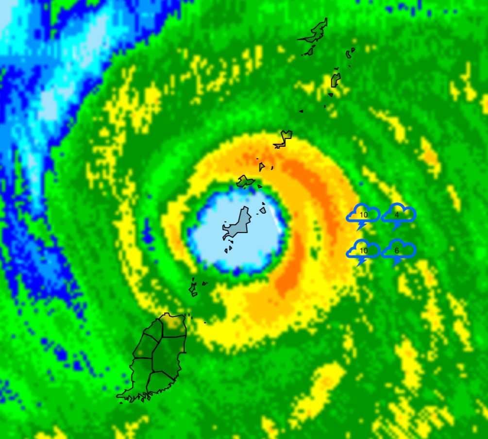
A radar picture to remember this storm by:

Highest winds likely on union Island. Even Canouan got a bit of the core with the larger eye. Surge up into Clifton harbor. Obviously near peak winds on Carricou as well.
-
12 minutes ago, CurlyHeadBarrett said:
Unreal now the EWRC has finished. She could make a run for a high 4. I’m worried for residents.
I bet she already is high end cat 4. The satellite loop showing on the CNN home page is a terrifying sight. Really shows the rapid recovery and symmetry of the eye

-
1
-
-
14 minutes ago, NorthHillsWx said:
Good News: this looks like it has gained enough latitude that the worst of the core might pass just to the north of Grenada.
Per the NHC track, the worst may miss Canouan to the south as well. Which puts a few very tiny islands in it's path, the largest of which has about 3,000 inhabitants
-
Dew point records are a bit unreliable, but it seems GSO has hit a DP of 75 for the first time since 2005
-
-
A saving grace for the islands could be the very small *core. Right now the track the entire core missing all the. Bigger islands.
-
1
-
-
26 minutes ago, Maxwell03 said:
Ditto call it a cusper because I would not attribute that speech to millennials
I'm the same age and have no idea what he's saying so....
-
2
-
 2
2
-
 1
1
-


July Obs 2024
in Southeastern States
Posted
The precip distribution actually ended up being fairly uniform surprisingly enough, but the precip cutoff was just a bit further East than modeled (we were living on the edge anyhow). Thankfully we got the heavy rain last Sunday that put a dent in the drought