

olafminesaw
-
Posts
3,063 -
Joined
-
Last visited
Content Type
Profiles
Blogs
Forums
American Weather
Media Demo
Store
Gallery
Posts posted by olafminesaw
-
-
3 hours ago, WinstonSalemArlington said:
Winter is coming closer ….
Ah CFS Snow maps. The telltale sign of a truly desperate person person

-
 2
2
-
-
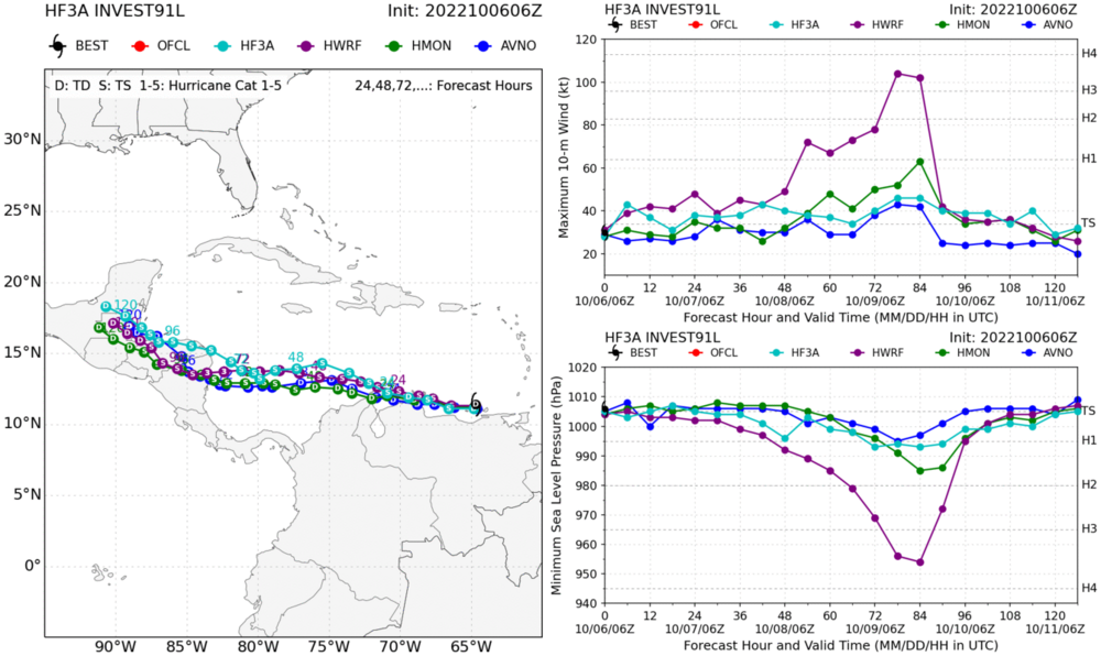
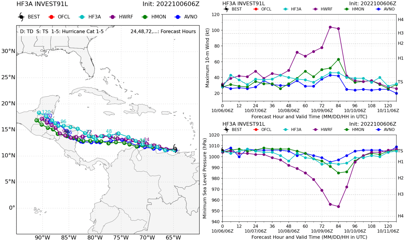
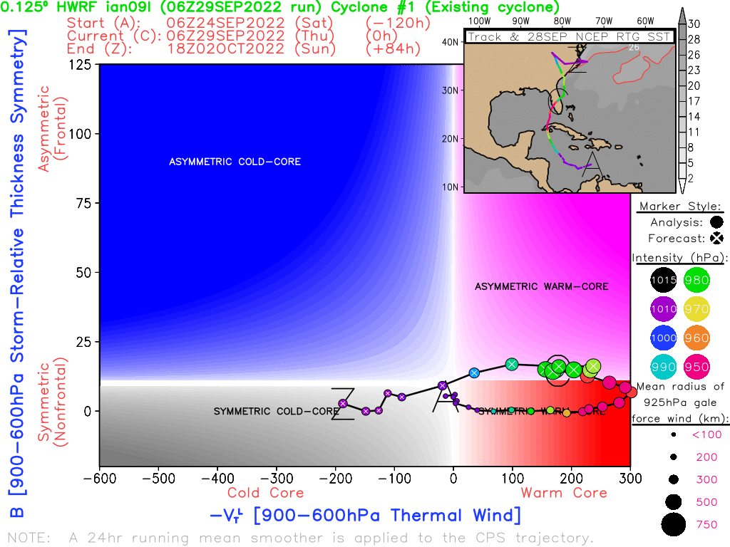
It will be interesting to see the battle play out between that HAFS and the HWRF. A good test case
-
This system is very Reminiscent of Joan in 1988. Thankfully will likely be hitting a sparsely populated area and flooding as usual, will be the main threat
-
10 minutes ago, twister4999 said:
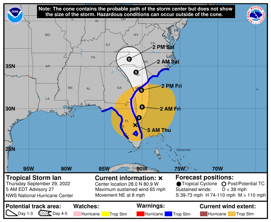
Lazy post here, but does anyone have the gif link to the NHC’s projected path through the entirety? It’s probably already been posted. TIA
https://www.nhc.noaa.gov/archive/2022/IAN_graphics.php?product=5day_cone_with_line
-
 3
3
-
-
Impacts from the storm across central NC will continue through early
Saturday. Heavy rainfall will lead to a threat of flash flooding,
especially this afternoon into tonight. Tropical storm force wind
gusts of 40 to 60 mph, with isolated higher gusts, are expected across
portions of the central, southern, and northwest Piedmont, Coastal
Plain, and Sandhills, with gusts to 40 mph elsewhere. In addition, an
isolated tornado can`t be ruled out across the Coastal Plain today
into tonight.
-
-
-
The overnight models seem to be indicating the highest gusts will be cut off right around the triad area. Depends, it seems, on how much the dry air to the north is able to cut off the convection as it pushes in . If heavier rain rates are still present as the center moves past Charlotte, gusts could exceed 50 mph, otherwise they may stay in the 40s
-
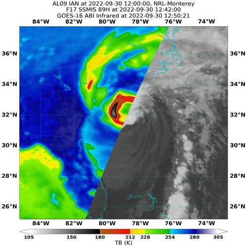
5 minutes ago, MattPetrulli said:
65 knot SFMR, which confirms NHC's upgrade to a hurricane earlier

Pressure down at least to 988 as well. NHC nailed this one
-
Recon is on its way, should be rather fascinating from a scientific perspective
-
 1
1
-
-
2 minutes ago, Eskimo Joe said:
^yes that. Got a link?
-
1
-
-
9 minutes ago, Eskimo Joe said:
There is actually. Folks have posted a link to a website that takes various remote sensing and NWP data and uses that to classify a storm on an X / Y plot as warm or cold core. I don't know the link, but it's a useful tool and would probably be a good visual explainer.
Took some digging but finally found it. Seems to be an asymmetric warm core for now

-
3
-
1
-
-
Not exactly your classic hurricane structure...

-
It's going to be wild tomorrow afternoon, legit tropical storm conditions and 55 degrees. You almost have to consider the wind chill sigh Ian

-
1
-
-
Looks like a recon plane is scheduled to head out at 7:30
-
1
-
-
If these winds mix down to the surface, that's no bueno

-
1
-
-
2 minutes ago, wncsnow said:
I think it's safe to say we won't be seeing another Ian ever. Have to be getting low on I names at this point.
Gotta start pulling out all the obscure Arabic names
-
4 minutes ago, OceanStWx said:
Overall I have a ton of respect for the NHC crew, my one nitpick revolves around the construction of the cone. It's only designed to capture 2/3 of the average track error over the last 5 years. As forecasts have improved the cone gets smaller. What it doesn't do is factor in situations where there is larger than normal forecast uncertainty. I would love to see a little more of that uncertainty factored into forecasts.
To be fair, Ian never once strayed outside the cone as far as landfall point (looking back at the graphics archive). I think there's a lot to be done in terms of communicating probability of different on the ground impacts. The general public has a hard time grasping what to expect.
-
5
-
-
6 minutes ago, CentralNC said:
I'm at least a little hesitant to jump on that bandwagon. Those winds often get overdone but no doubt there will be some power outages in the piedmont.
For sure. I think 40-50 mph is possible, but much more than that is unlikely. The current forecasts don't seem to be calling for much in the way of wind, so it may catch some by surprise, although it seems because of what happened in Florida, many are at least weather aware.
-
I'm growing somewhat concerned about the wind threat across the Piedmont. While sustained winds diminish, the HHHR and the hires Nam have gusts over 60 mph for much of the region, the GFS in the 40-60 mph range, and the Euro in the 30-40 mph range. There must be some synoptic scale features at play. Usually the HRRR does a good job of picking up on these, but we may not have a clear idea until tomorrow morning what's coming our way.
-
1
-
-
HAFS makes landfall near Charleston as a borderline cat 1
.thumb.png.faae5898911ea6b2e8564158e708b3dd.png)
-
1
-
-
Largest TS force wind field at this latitude since Sandy? Could push some serious water into Savannah/charleston
-
 1
1
-
-
10 minutes ago, kvegas-wx said:
I'm confused with the lack of comments in this thread. We have a rather serious flooding threat headed our way and a potential landfalling hurricane within the Carolinas or Georgia. Are we just monitoring the main thread or posting updates here? Nobody wants to talk about severe flooding in western NC but we are 72 hours from that potential reality. So what gives?
I also think the dry stable air is going to mitigate the threat of winds/flooding. Fresh water and coastal flooding will be a rather big deal for coastal SC though.
The 18z Euro

-
1
-
-
Yellow is 14", white 20"


.png.2652598ffafe83c3e6295d44aff5ab23.png)


Julia | 85 mph 982 mb peak | EPAC Crossover #2
in Tropical Headquarters
Posted
Only six storms have passed within 50 miles of PTC 13 in the satellite era, of which, 5 became hurricanes and 2 became major hurricanes