

olafminesaw
-
Posts
3,060 -
Joined
-
Last visited
Content Type
Profiles
Blogs
Forums
American Weather
Media Demo
Store
Gallery
Posts posted by olafminesaw
-
-
If it becomes a hurricane, it would be one of the furthest north forming hurricanes on record. The only other one I could find in the NOAA database is Lisa (1998)
-
Mighty impressive. Surely upwelling will hold back intensity for the next couple days though? Or does the subtropical structure negate this?
-
9 minutes ago, MJO812 said:
When was the last time that August didn't feature a named storm ?
Looks like 1997
-
 1
1
-
-
Yeah, the GFS is broken. Wake me up when the Euro shows development within 84 hours.
-
1 hour ago, NorthHillsWx said:
One point you make that I truly agree with is that few storms with very high intensity several days out end up the strongest at landfall. It always seems the most powerful landfalling storms are the ones that rapidly strengthened into or just before landfall. Ida, Harvey, Laura and of course Michael are great recent examples. And of course Dorian in the Bahamas. Very rarely does a storm mature days out and hold onto a similar high-end intensity into a US landfall. Even Katrina, Rita, and Irma were weakening upon landfall
Camille is the one except that comes to mind. Pretty much held strength from the time it entered the gulf all the way to landfall
-
I'd be curious to what degree the shut-off of the EPAC about two weeks ago has an downstream impact right about now. I know the two basins are inversely correlated (at least with respect to a typical la Nina), but not sure what kind of causation is there
-
I can't help bet have a gut feeling that while we won't get big numbers this year, we'll get a Hugo/Isabel type track at some point
-
1
-
-
20 minutes ago, ldub23 said:
This was issued Aug 09 and its been dead since then. I have averaged out the numbers. 8.5 hurricanes, 4 majors, 138 ace for the remainder of the season. All i can say is if we get to these numbers it will be a wild ride indeed. Im doubtful, but read for yourselves.
https://www.cfact.org/2022/08/18/2022-hurricane-update/
"I think we will see a fast and furious period from mid and late August into early September, followed by a lull and then another active period. I don’t have any below normal risk impact areas, though there certainly will be when the season is looked at retrospectively."
Mid to late Aug is here and no canes, no majors.

-
1
-
 5
5
-
-
On 8/13/2022 at 7:09 PM, WinstonSalemArlington said:
Best week of this summer so far?
Of course, as soon as it cools down we end up with cloudy/drizzly weather for a week straight. My elderly HVAC unit is loving it though (and I'm not complaining
-
1
-
-
You love to see it...
-
1
-
-
Meanwhile, the 6z GFS had 4 hurricanes develop in the EPAC over the next 10 days
-
2 hours ago, John1122 said:
Looks like SW VA is taking it pretty hard from flooding. That fire hose across SE Ky into there was persistent.
All the little towns that don't get much coverage when this happens
https://twitter.com/walkyourcamera/status/1552708976134995969?s=20&t=IRDWn31TY4ZBjmpQrp1MAg
-
 3
3
-
-
Kinda surprised we didn't get a FFW here. 2"+ in an hour. Also winds gusting steadily in the 40-50 mph range for a while and constant thunder. Top shelf storm in my book. Fun without being too wild.
-
33 minutes ago, Chicago Storm said:
Crazy stuff around the STL area overnight and into this morning.
The 12 hr 1000 year flood threshold is 9.5" and 24 hr is 11.1". Many locations are at or approaching those values.
-
This morning's 12z sounding was quite toasty aloft. GSO recorded a daily record of 15,600 ft freezing level (previous record 15,460)
-
1
-
-
Let's go!

-
4
-
-
33 minutes ago, WinstonSalemArlington said:
Excellent points. I guess what really struck many of us yesterday was how isolated to the Triangle and Sandhills the big heat was. The Triad was unremarkable yesterday, while RDU was trying to historic. Even normally hottest Fayetteville was cooler.
I wonder if urban heat island is a significant contributing factor. The Triangle has had significant growth even in the past few years, since the last major heat wave.
-
1
-
-
41 minutes ago, NorthHillsWx said:
Upgraded to an excessive heat warning today. We verified one yesterday despite only having a heat advisory. Heat like this, even in the south, is quite rare. Usually our dew points mix out in the afternoon at peak heating but this is a pure soup airmass. Hope the advertised pattern changes noted above come to fruition. This has been a miserable summer
Meanwhile, GSO only reached 93 yesterday with similar dewpoints. A combination of elevation and cloud debris coming off the mountains has consistently kept high temps much more reasonable (and also at times set up a boundary for storm development)
The data backs up my theory. The average high temp in June was 3.2 degrees higher at Raleigh than at GSO (90.0 & 86.8), compared to the historical average having a gap of 1 degree (86.1 & 85.1)
-
It seems the drought regions of Eastern NC should finally get soaked. When it rains it pours: 3-5" for the coastal plain over the next 5 days
-
1
-
-
The HWRF has Bonnie making landfall in Costa Rica as a TS. A TS or stronger has never made landfall in Costa Rica in the satellite era, looking at the NOAA database
-
1
-
-
1 hour ago, NorthHillsWx said:
Really getting worried about falling into a drought this summer. We’re sitting at 0.69” for the month and this hot weather has made it seem even drier than that. Hope storms this afternoon move west enough to get us some relief
Yeah, thankfully the triad has been somewhat more fortunate in regards to rainfall this month, but it seems that a flash drought is perhaps underway. High temps and remarkably low RH, will dry out the soil quick, even here.
-
1
-
-
It seems showers/cloud cover should keep temperatures in check today for the western Piedmont. I wouldn't be shocked if we struggled to reach 90. Friday may end up as the hottest day of the week.
-
2 hours ago, turtlehurricane said:
Tropical Storm Warnings now in effect for the Keys, all of South Florida, and alot of Central Florida. Track shifted a bit south, cause I wasn't even in cone before, but now I'm in the actual cone.
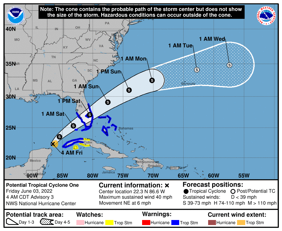
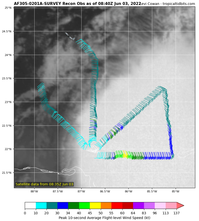
Recon found that this has tropical storm force winds, but the center was ever so narrowly unclosed. However, in storm relative motion it obviously is a closed tropical cyclone. We could easily see this declared Tropical Storm Alex by 11 am.
Also, really cool feature passing by South Florida right now. A secondary circulation generated by all the deep convection yesterday has become exposed, showing up good on both satellite and radar. And it has a decent amount of inclement weather swirling around it, so a big swath of rain is spreading over South Florida as this secondary mid-level circulation passes by.
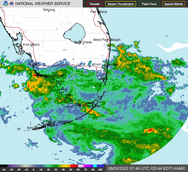
Of course, the fact such a feature exists is a tell-tale sign of the powerful shear that is warping this tropical cyclone. There is some serious diurnal max convection going up, but the convection is quite elongated and almost completely off to the east of the center.
That being said, in a case like this, it's possible convection will wrap around center at some point, and I've seen scenarios where that leads to really fast intensification and very severe weather around the center in sheared systems.
Seems like the type of storm that could tighten/strengthen over land
-
17 hours ago, buckeyefan1 said:
Hopefully a nice enhancement to the needed rain this week


Someone is going to get pummeled (3"+) but more likely the western Piedmont/mountains and drought regions may be much more modest in the rain department.
-
1
-


Hurricane Earl
in Tropical Headquarters
Posted
Yeah, would be wild if after this it ends up threading the needle and developing after staying weak through the Bahamas and ends up impacting the East Coast. Ensembles show the weaker solutions heading that direction