

olafminesaw
-
Posts
3,754 -
Joined
-
Last visited
Content Type
Profiles
Blogs
Forums
American Weather
Media Demo
Store
Gallery
Everything posted by olafminesaw
-
I don't think it dropped, thank goodness
-
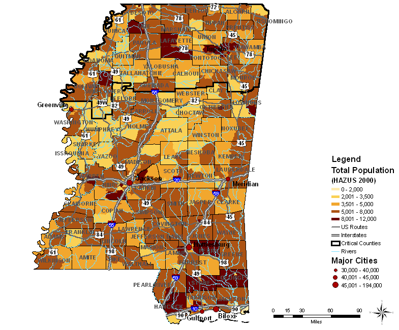
Big debris ball heading into the west side of Collins. Hoping it can miss just to the West
-
Will head through a relatively populated part of the state
-
-
While things are relatively quiet, any thoughts about tommorow in the Carolina's? Seems like the SPC outlook is pretty tame while local mets are hyping it up a bit.
-
My bad, I misremembered. I do feel though they are a world a way climate-wise. Would be nice to have more posters from those states
-
I agree, but it does suck that AL & MS don't really have a subforum that's truly theirs. Technically they fall on the western states sub, but nobody posts there from the deep south
-

March 14-15 Severe Weather Outbreak
olafminesaw replied to HillsdaleMIWeather's topic in Lakes/Ohio Valley
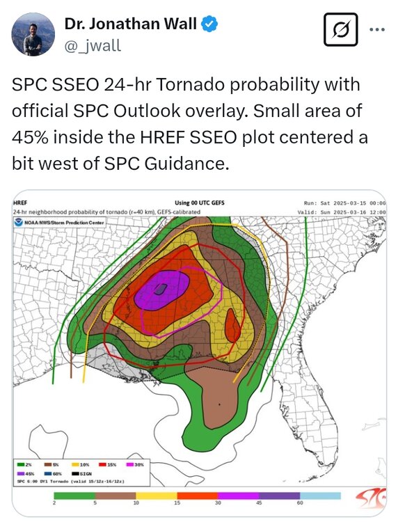
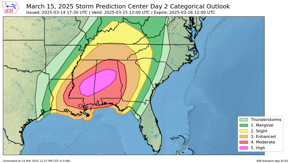
Parts of Alabama are in the moderate day 1 and high day two -
Pretty darn close
-
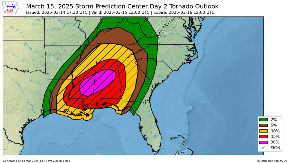
They actually reduced the wind threat, removing the 45% area entirely. I guess that may be due to increased confidence in super cell storm mode, which don't tend to produce a wide swath of high straight line winds
-
-
Day 1 for the Midwest in the discussion. Probably better question for the Lakes/Ohio valley subforum, kinda forgot this was the SE thread!
-
Today's SPC discussion mentions gusts of 60-100mph. Can anyone think of a time when the SPC mentioned wind gusts that high, excluding Derecho setups?
-

-
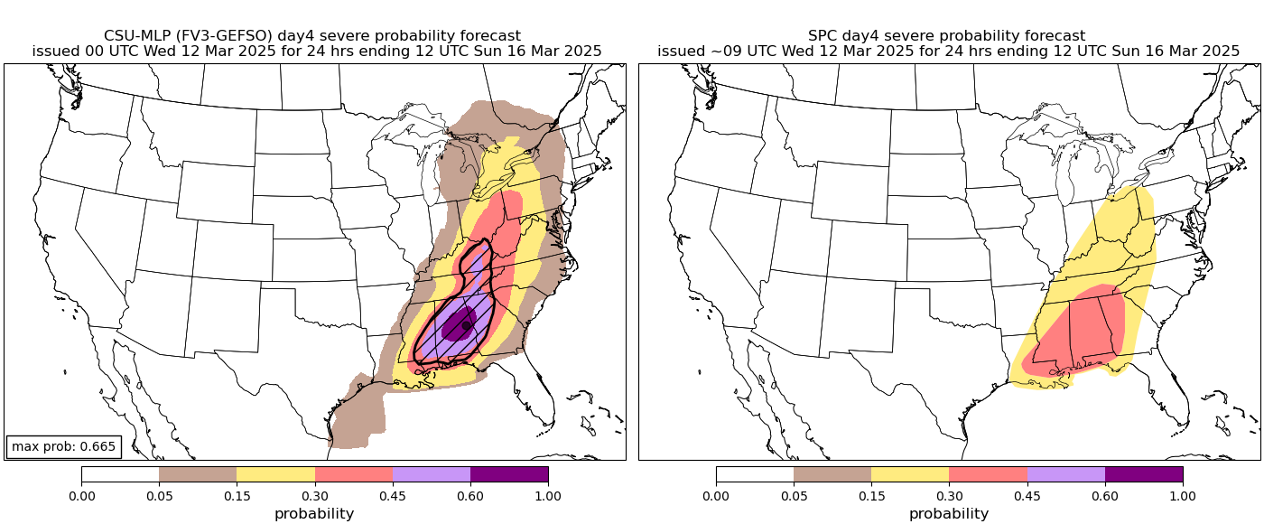
This AI model is a bit more aggressive for the Carolinas. I love a good strong storm, but hoping that we can keep the high end stuff from materializing.

-
I don't know if I can think of a single storm system over the past 6 months that didn't lose momentum once it got into our region. 6 out of the last 7 years have been above average rainfall, so this may buck the trend and be below average.
-
Focus of this one seems to be west of the Apps for now thank goodness

-
It would seem based on obs, that little or none of this band is reaching the ground . Quite a dry airmass!
-
One last fantasy run for old times sake?
-
We also just forget what a below normal winter feels like. The cold stretches were fairly impressive but mainly because they were sustained rather than because of near record cold. In fact, the coldest low of 15 at GSO is above the average coldest temp of 9. The min-max was somewhat more impressive at 23 vs the average of 27, putting it in about the 25th percentile.
-
-
Lol!
.thumb.png.b52d67e19e79766f777dbc4c7f42bcf1.png)
-
Comparing the 9z sounding to current on the HRRR, check out the lift on the left hand side, seems the drizzle was a result of subsidence, stabilizing the atmosphere (even though neither sounding has CAPE)
.thumb.png.1623aaa8f4058527d1a805366893e652.png)
.thumb.png.1a3e55dfd40c1d86d202bcc5af1bf9af.png)
-
The line is picking up steam as it enters the more favorable environment
-
Almost had a microburst look to it. I'm assuming the bow echo was able to bring down higher winds aloft, has weakened since


.png.63ca0024dcc1d9da189f0a7b930c5f8f.png)
.png.a8adefb8b1e72ae7b90bfd570c5e4312.png)
.png.e627edadfafb5d6cfe941b15875cd9a5.png)