
michaelmantis
-
Posts
283 -
Joined
-
Last visited
Content Type
Profiles
Blogs
Forums
American Weather
Media Demo
Store
Gallery
Everything posted by michaelmantis
-
-
That line of storms in Northern Kane/Dekalb counties just tossed a few minutes of pea-sized hail near me. Wicked sound all around the house.
-
Feb 22nd/23rd "There's no way..." Storm Thread
michaelmantis replied to Maestrobjwa's topic in Mid Atlantic
What’s the start time for all of the heavy stuff? This more an evening/overnight thing? -
Feb 22nd/23rd "There's no way..." Storm Thread
michaelmantis replied to Maestrobjwa's topic in Mid Atlantic
Pulled the trigger and moved my flight to Chicago to 11 am Sunday from 8 pm. Looks like temps through early afternoon in the DC area look to be above freezing. Us Chicagoians saw all the hell you guys went through a few weeks ago and even we though “damn that’s crazy” :-) -
Feb 22nd/23rd "There's no way..." Storm Thread
michaelmantis replied to Maestrobjwa's topic in Mid Atlantic
Ha. Been the last few years (was beautiful). Just a quick weekend conference, DC in February was not my first choice! Whats the timing of this looking? May split the difference and try for an earlier morning flight. -
Feb 22nd/23rd "There's no way..." Storm Thread
michaelmantis replied to Maestrobjwa's topic in Mid Atlantic
Long time poster in the Ohio Valley / Midwest forum. Heading to DC this weekend for a conference with a flight scheduled back to Chicago for 3 PM on Sunday. Thoughts if I should move it earlier or try to get out late Saturday? Really seems like this is going to be a biggie for the DC area or nothing (crazy 48 hours out, it's like my Chicago storms when the Lake plays a factor!) -
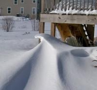
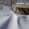
Even after the all evening rain, still looks to be 3-4 inches of snow all around on in my neck of the woods that is quickly becoming a glacier. Now just need a few inches to give it a nice look again. Sick looking out the window and the nice winter scene with what remains from a-hole people walking their dog shitting and peeing without cleaning it up.
-
I'm all good with a refresher snow once a week of 2-3 inches for the remainder of the winter. Pixie dust got a bit stronger in the last 15 minutes. Widespread 1-3 in N IL will hide some of the dirty snow and leaves.
-
Nov 28-30th Post Turkey Day Winter Storm
michaelmantis replied to Chicago Storm's topic in Lakes/Ohio Valley
I was just checking that out and the last few radar frames look decent. That could be the 1-2 inch topper to a great day. -
Nov 28-30th Post Turkey Day Winter Storm
michaelmantis replied to Chicago Storm's topic in Lakes/Ohio Valley
Looks to be a little hole of no precip a bit SW of Aurora (around 3 PMish) heading my way so I'm going to clean the driveway. Hope that fills in a bit. Few more inches would make this a great storm. -
Nov 28-30th Post Turkey Day Winter Storm
michaelmantis replied to Chicago Storm's topic in Lakes/Ohio Valley
We are just started and this surpasses anything I remember last Christmas. Another 1.5 inches (up to around 3ish depending on where I measure) for a total of 3.5ish. And this thing still has 6+ hours to it at least in N IL. -
Nov 28-30th Post Turkey Day Winter Storm
michaelmantis replied to Chicago Storm's topic in Lakes/Ohio Valley
2 inches on the ground as of 10 AM. Flake quality in last hour improved a ton. No huge flakes yet, but this new stuff is stacking nicely. -
Nov 28-30th Post Turkey Day Winter Storm
michaelmantis replied to Chicago Storm's topic in Lakes/Ohio Valley
For the first storm of the season, coming out of a bad 2024-2025, all the signs seem to be good for IA, S WI, and N IL. -
Nov 28-30th Post Turkey Day Winter Storm
michaelmantis replied to Chicago Storm's topic in Lakes/Ohio Valley
After last winters lack of snow in my part of Chicago (Far NW burbs), I'm not getting hopes up. Our last seasons best shot of snow went from 6-8 inches to a dusting within 9-12 hours between "jackpot model run" and "reality". Are patterns really changing that much or do we just have more "data points" (that don't need to be real data points they could be model hallucinations or just model gunk) that it *seems* like things are changing? -
And the towel is thrown in for most of NE IL. Amazed as the number of schools that canceled today. I'll believe the weekend storm when I see flakes. Was hoping to have a good week or two of storms and missed these threads!
-
LOT going with WWA #### .UPDATE... Issued at 1131 AM CST Tue Feb 11 2025 Quick update on tomorrow`s snow... After getting a look at 12z guidance, the trend of the sfc low being slower to deepen, thus farther east of the area continues. The result is lower QPF versus yesterday morning`s (and prior) guidance, so amounts that had looked to be borderline high end advisory/low end warning, are now looking more solidly advisory. As far as impacts go, snow, possibly heavy at times, is expected during the day tomorrow, likely causing significant travel issues. Ultimately, there really isn`t much difference between a 3-6" snow vs a 4-8" snow, so the key messages for the event remain largely unchanged. Still looks like southeastern CWA could see lower snowfall totals, but snow could mix with/change to some freezing rain or freezing drizzle Wed evening. So will be upgrading the winter storm watch to a winter weather advisory for our entire CWA.
-
My first time posting over here (hang out at the Great Lakes forum!) Was going to head to DC for Carter's memorial services with a flight out of Chicago on Monday morning. Looking like that may not be the best idea? This storm being tracked here is goign to hit the middle part of IL (I'm in Chicago) and looking like 3ish for DC seems like a safe bet right? Debating if I should cancel my trip.
-
The Tuesday track shows this over water again but with so much time over land my hope is this thing turns into just a rainmaker going forward. Amazing that this is moving so slow. I just don't see how this thing gets into the Gulf Tuesday AM and is by Florida by Wednesday PM? Is the front/trough coming down from the US just going to pick this thing up and throw it toward Florida.
-
Flying into Florida (Orlando) a week from Friday in the afternoon. From looking at the model runs this looks like a Wednesday or Thursday impact? Wasn’t expecting to be thinking about a hurricane around Thanksgiving week. if I’m understanding things right, the entire path once it gets away from the Yucatán is dependent on the troughs coming out of the Central, United States, correct?
-
Winter '23-'24 Piss and Moan/Banter Thread
michaelmantis replied to IWXwx's topic in Lakes/Ohio Valley
The morning snow was legit. And it was heavy as hell. If *exactly* what fell was forecast in advance, as a weather nerd I would have loved it. The potential was there for a bunch more but it just didn't. Models are models and the whole downside of all the ensemble models is that someone can find just the scenario that works for them. As I type this (12:20 AM on Saturday) we're getting another 2-3 inches of back side snow that is actual snow, not slush or a mix. Will be a nice cover when the deep freeze hits. Wind picking up and it is going to be a shitty week of insanely cold weather. All in all, a great storm and a forecast that was pretty darn good given the warm air impacts all around the NE IL and N IN areas. -
Better falling off the trees now that freezing and blowing around later.
-
(For now) has transitioned back to all flakes. 5 miles east of me it's drizzle/sleet. Slush everywhere.
-
Looking at the trees dripping a bit, just realized this stuff is going to turn into a solid ice cube in the next 24 hours. If it's not shoveled or moved it is staying there a while.
-
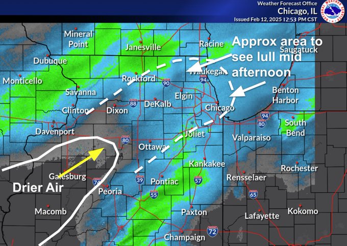
That hole between Elgin and Joliet looks to be trying to fill in. Wonder if I can get greedy and wish for that band between Rockford and Galesburg to park over my area for a while.
-
Exactly. When we get a decent storm (especially one with some great rates) we all should be grateful and save bitterness for the next storm. ;-) Wonder what the water content of this snow was. Could have easily fluffed up double I'd bet...


