michaelmantis
-
Posts
283 -
Joined
-
Last visited
Content Type
Profiles
Blogs
Forums
American Weather
Media Demo
Store
Gallery
Everything posted by michaelmantis
-
Perfect "frosting" to cover up the nasty from the plows. Perfectly white outside now!
-
And it looks like the event is going to be over for me! Now time to shovel! Decent little event and the models actually handled the cut-off (in N IL anyway) very nicely it appears.
-
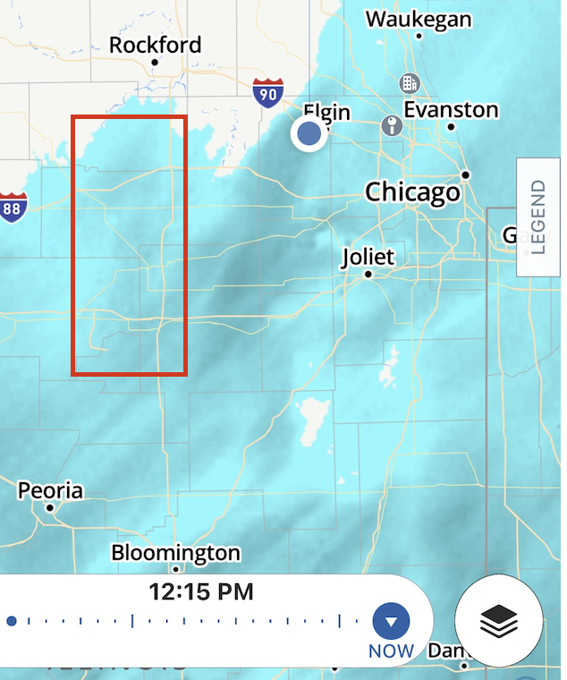
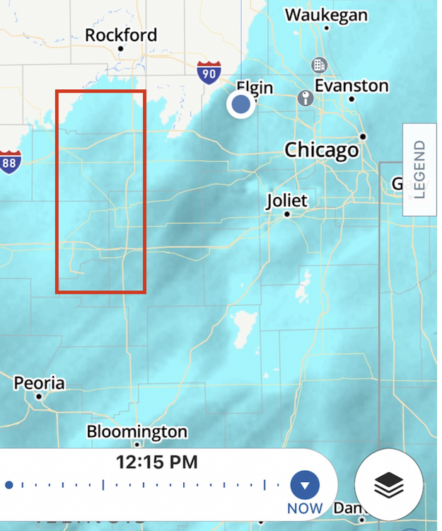
I'm in Elgin IL (Northern Kane around I-90) and *right* on the borderline of the snow line ending on radar (as of 12:20 PM) and the flakes are best of the event right now in my area. Looks like something may be trying to build up again around I-39 and I could squeeze an inch or two more out of this on the razors edge.
-
19.6 in to 1.8 in 30 miles!?!?! Come on slight NW shift (no wammies, no wammies...)
-
Snow is just drying up NE of I-39 and I-88. Someone in N IL is going to drive 10 miles Thursday and go from a dusting to 6 inches for sure. Now just where does that set up.
-
Bookmarking this post and time as the time where hope was lost or something unexpected "changes everything". HA!
-
We need to get together and Venmo you some cash to distract you for a bit, we'll let you know when something good gets posted ;-) Just enjoy the better view from where you are at.
-
So close yet so far. Amazing how the dew points factor into the cutoff.
-
Throwing in the towel (Elgin, IL). Good luck to those south and I'll enjoy living through the joy of others!
-
Anyone know what the NWS uses to compute their "probabilistic" snowfall forecasts? https://www.weather.gov/lot/winter Someone is going to get a surprise out of this storm in N IL, from Rockford to Valpo there is a *huge* cutoff! Enjoy whomever gets the thumping. This winter I consider 3 inches a decent event just to freshen things up. Anything else is bonus!
-
Friends in Seattle and Portland posting snow covered Boxing Day pictures is making me chuckle. I've thought for a while now that "winter" in N IL is going to be 2-3 weeks of very cold combined with a few storms during that time that all add up to a combined 12-18 inches over that few week period and that will be it. Now I just want to know what weeks those will be! :-) Hope all is going well, looking forward to the threads and chat once *something* looks like even a dusting of snow may hit that Great Lakes!!!
-
Looks like something is trying to pop up on radar on the IL/IA border around 12:45 AM. Not confident anything will last or move into N IL but it's still 80 degrees out at 1 AM so there has to be *something * to work with if things get started.
-
Beware the Ides of March (and into the 16th)
michaelmantis replied to Hoosier's topic in Lakes/Ohio Valley
Sounds like someone is shooting sand at the house... Going from heavy sleet, to fluffy cotton balls, and back and forth. -
I like the radar returns in Lake County IL starting to fill in. It's a dream for that Lake Band in NE IL to come in 40 miles but at least a little enhancement would be great!
-
Now if just the Snow Gods would have given us a heads up 2 months ago this was going to happen it would have saved a lot of complaining (and posts here) ;-) I'm out of the Lake Snow part of this but great to see the scope of this and hope people take this seriously on the roads.
-
Calling 4 inches with anything more being a pleasant surprise. The distance from the west border of Kane County to the lake is ~40 miles and from my house to where the yellow starts in NIL is only around 10 miles. The snowmaps SE (essentially all of Indiana) are a beauty as well.
-
Looks like returns are starting in the Peoria/Galesburg area and if I recall isn't the precip field supposed to start expand/filling in around the eastern 1/2 of N IL later today? Checked through some of the 3AM posts earlier in the thread and how is the current precip performing to the modeling? With this lake effect and sharp cutoff in NIL as you move west, a track change of a bit will have some big population impacts. I said it yesterday and I'll say it again, all the pink on the NWS Watch/Warning national map is a beauty... I want to frame it...
-
Looking forward to your posts today!!! ;-)
-
From where I'm at a bit out West (and a bit higher up in elevation than the O'Hare and downtown area) I can see the lake effect clouds clearly (while the sun shines here). Hope you guys in the city get the big daddy expected. I'll watch from the cheap seats out West and hope a favorable wind drops an inch or two of added fluff!
-
Going to be a sharp cutoff in Kane County is that verifies! Seems like Cook County is a lock for this, collar counties look to be a nowcast.
-
I'l be happy with 4ish for those of us out in the eastern part of Kane county. I have family near O'Hare that has no idea they potentially are going to be buried if the current forecast holds true.
-
How does the storm track impact the lake effect in NE IL? Is it a case of further west of the track the further the lake effect or would that just mean the same general amount of lake effect but greater totals from the "system snow"
-
The national warning map is a sight to see... The cutoff is just amazing too...
-
Trying to convince my parents they are either going to get 2-3 inches or 8-12 depending on how the LE shapes up. It’s a fun conversation. ;-)
-
Thanks for the added detail. Can you explain the science behind what determines how far the Lake effect snow travels? It is the case where if a single band stays in one area it can “push farther” inland? I like the AFD overall message that Monday night into Tuesday is going to be messy in Cook County. That seems like a reasonable and justified message and not getting pinned down into what essentially is a nowcast for LE band setup. Glad NWS divided up Cook into a few warning areas. Absolutely helps in cases like this.