michaelmantis
-
Posts
283 -
Joined
-
Last visited
Content Type
Profiles
Blogs
Forums
American Weather
Media Demo
Store
Gallery
Everything posted by michaelmantis
-
Approaching 2.5-3 inches for the 24 hour period (2 inches in last 2 hours) depending on which rain gauge I use. Looks like something is trying to build in intensity south of Rockford, maybe the main line won't be the last of it...
-
Line in N IL just started by me and its a monsoon rain. This thing is no joke and if it doesn't move fast there is for sure going to be flooding north of I-88.
-
Some nice cells just popped up a few minutes ago west of Madison... Enjoy!
-
Izzi really hitting the Flash Flooding concerns in N IL. Radar looks beautiful but scary. The rain that has fallen so far has been tropical-like (huge sized drops).
-
Severe Storm Watch, Flood Watch, Special Weather Statement, and storms in Kane County popping up in last 15 minute. It's on...
-
Lake breeze right over my house in N IL (can clearly see it on satellite from South Side of Chicago all the way up past Milwaukee) and this has the feeling of something popping nearby soon or that stuff starting up in IA to grow really fast.
-
Not looking like much will develop in N IL. Keeping an eye on the visible satellite to see if anything can pop. https://weather.cod.edu/satrad/?parms=local-N_Illinois-02-24-0-100-1&checked=map&colorbar=undefined
-
2023 Short/Medium Range Severe Weather Discussion
michaelmantis replied to Chicago Storm's topic in Lakes/Ohio Valley
The storms in NW IL and East Iowa blow up nicely on the visible satellite in the last hour. https://weather.cod.edu/satrad/?parms=local-N_Illinois-02-24-0-100-1&checked=map&colorbar=undefined I was less than a 1/2 mile from the storms the hit N IL in Elgin a few days back (found a bunch of insulation from homes nearby in my backyard that fell from the sky while cutting the lawn today) and our area could use a break. About 3 dozen houses with tarps as roofs so hope there isn't a storm coming through this way and it passes us by. -
Two rounds of pea sized hail in South Elgin occured around 1 PMish. Weird thing was after the first round it got sunny for about 10 minutes and then another downpour.
-
50 minutes later and that changed fast. Cotton balls falling, very pretty. I'll take it.
-
Looking like North of I-90 in IL has started as snow and I'm 5 miles south in Kane County and nothing yet. That doughnut hole needs to close or the "sharp cut off" will be closer to I-90 than I-88!
-
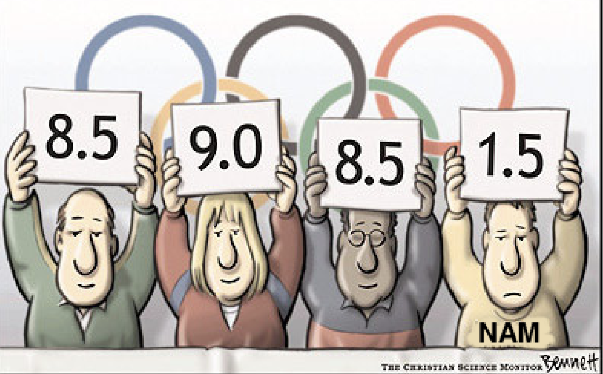
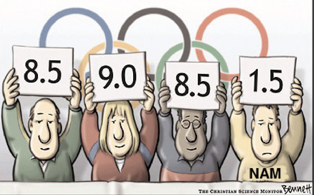
Back to the Future of 2015 didn't come (where are my flying cars?!?!?) but I do not think *any* of us here who are not full-time NWS employees who have degrees and expertise and built careers around forecasting the weather should use words like "laughing" to discuss reactions to official and public forecasts. It's not the 2015 of Back to the Future, we can't tell people the minute rain will end and we can't figure out that Chicago will get 5.2 inches of snow while Rockford get 4.9 inches 36 hours in advance. The guidance and ability to predict continues to improve (even if the NAM sucks). A model/forecast/prediction can still be wrong. Otherwise I'd be going to Vegas right now betting the farm because I knew "the odds" were exactly in my favor. Lets just be civil.
-
And damn Ricky did not disappoint...
-
Looking forward to Ricky's storm-specific update coming soon! Seems like lower totals overall but may be trending a little bit south in N IL. #### Area Forecast Discussion National Weather Service Chicago/Romeoville, IL 256 PM CST Wed Mar 8 2023 .SHORT TERM... Issued at 253 PM CST Wed Mar 8 2023 Through Friday... Key Forecast Messages and Concerns: * Winter Weather Advisory has been issued for the I-88 and northward counties/zones, including WI state line counties which were previously in a Winter Storm Watch, starting 3pm Thursday near/west of Fox Valley, and 6pm Thursday closer to the lake * Very wet/dense/heavy snow once again, and temperatures starting a few to several degrees above freezing casts uncertainty regarding timing of worsening impacts Thursday afternoon * There is support for heavy snow rates up to an inch per hour causing impacts to part of the Thursday PM commute, though likely shorter duration of heavy rates and low SLRs points toward 12-hour snow amounts generally below 6" * Highest snow amounts remain forecast for the state line counties at up to 4-7" by the time the snow ends early Friday * Consideration of expanding the WWA a tier or two of counties southward toward I-80 corridor may be warranted depending on guidance and observational trends Tonight will be quiet and dry under the influence of surface high pressure ridging southward across the Great Lakes. Expecting cloud cover to balance out as mostly cloudy, with lows in the lower to mid 30s by early Thursday. Meteorological Details for Thursday PM-Friday AM Winter Weather: To be issued shortly. Castro
-
Anything more then 4 inches here would be largest storm of the season for me. Looking decent for I-88 and north in N IL.
-
Since we're all a bit jaded with the models...
-
I keep coming back to a line from the TV show "The West Wing" where the President says "'You don't live longer, it just seems longer" and I wonder if these model quirks are really the result of having more data (even if it is bad data) available or if it just *seems like* we have more data and thus give the models more credit than they deserve. A broken clock is right twice a day and the NAM is going to be spot on occasionally. The extended forecast period (as I believe) used to by 5 days, then 7, now 10 days. Technology got better and our ability to see things earlier helped forecasting. But these 24-36 hour model swings are really where it baffles me. Yes I get that 100 miles of a storm track forecasted a week in advance is damn good, but that same shift in 24 hours causes a lot of disruption, extra costs of time/money/people, etc. Someone posted last night the NWS putting out a forecast with "snow ranging from 2 to 10 inches" (and I loved @RCNYILWX reply) and right now this winter has proven to me that the models even are struggling with a 24 hour Nowcast of some of these events and I just wait until the day-of to adjust activities due to potential weather. If I was the NWS I am not sure what I'd do. They *have* data, they *have* models, they are not just making up or wishcasting. But how does the 3 PM shift write the AFD (and send the public messaging) when I'm sure many times they know/feel the 3 AM update is going to flip flop potentially with a huge model change?
-
I am the "weather guy" for my family and the one who gets all the texts about "what is the real forecast". I saw a local Chicago met toss up a bar chart of 4 models ranging from 1.2 inches to 10 inches. I can't see how that is helpful for the general public. I told my family to be aware Friday morning there may be some significant snow during the day or there could be a cold messy mix. It almost seems like a "impact scale" should be the way this is publicly communicated. 1 inch of snow during rush hour is more impactful than 3 inches of snow overnight on a weekend. Regardless, the NWS will never win. They are in the bad position of being seen as too conservative, too agressive, late to the game, etc all at the same time!
-
Nice hit for our area if it verifies. I'll take 1/2 of this and then hopefully put away the snowblower for the year.
-
Also the fun of the storm goes away when it melts practically the next day or two. Bring on Spring!
-
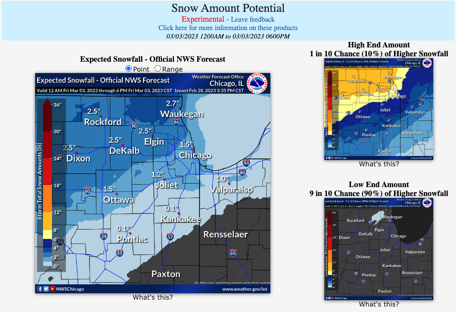
First pass from the NWS Probabilistic Snowfall website from LOT... Quite a spread! https://www.weather.gov/lot/winter
-
School district closed for a second day due to power outages still. Damn.
-
I could not believe the impacts this thing had out my way. I was about 15 miles farther west than ChicagoStorm and it was *bad* out here. School canceled (power fluctuations at local high school caused a small fire) and lots of limbs down. Rural roads were icy and the buses just could not get out this morning. My birch tree survived but man it was leaning a good 30 degrees. People a few blocks down have been without power for 15ish hours. Part of old Elgin (where there are above ground lines) got it bad. All melted within a 90 minute period before the wind started. So that was a saving grace.
-
I've never seen as much ice in 15 years where I live. Birch tree still standing but that thing is creeking and bent over and when the wind starts up it is a scary sound. Roads seem perfectly fine (was out a bit) but *everything* above ground is covered with a decent glaze. The wind forecast tomorrow scares me, only saving grace is my forecast says temps should rise to the upper 30's before much of the wind starts. Sustained winds with the ice on trees now would be a huge problem.
-
Noticing the wind picking up for the first time. No pingers, just rain on the windows/house. Drive safe everyone if you have to go out.