

Typhoon Tip
-
Posts
44,565 -
Joined
-
Last visited
Content Type
Profiles
Blogs
Forums
American Weather
Media Demo
Store
Gallery
Everything posted by Typhoon Tip
-
Wondering if black ice/ flashing later this evening... Lot of day after commuters. The near/backside cyclonic escape environment is likely to feature a rather abrupt acceleration of wind imparting crashing thickness via very efficient CAA. NAM has T1 going from ~ 6C to 0C between 00z and 2am with weak windex appeal there.
-
thing is... long years of experience - I've seen the NAM day dream like this before and hiccup fore' and aft of the stream line placements But that said .. it may be worth it to note that the mechanics are as of this 12z run grid filling ( however they do that over the eastern pac waters in/over B.C. ).. are just relaying over the denser physically materialized soundings, and oh gee - subtle morphology also materializes down stream. High sensitivity -
-
Interval comparison of the this 12z NAM run vs the prior two ... the defining difference to me isn't the strength of the N-stream. The wind momentum in either run's rendition isn't discernibly different, even down to the nuanced level. The difference between this 12z version, vs the prior two, is the timing in free space. The prior two runs have the best assessed N-stream trough axis ~ midway between Buffalo and Detroit longitude, where as this 12z run lagged back of eastern Michigan. That variance is opening up the wave-spacing wrt the surroundings - the closed 528 dm isohypses over the Lakes at 51 hours is likely more for that reason of increased spatial ownership in the flow for one. But the 2nd aspect is the clipper mechanics have 6 or so more hours to go to work before leaving the region ... coastal response ends up further west.
-
Hard to know for certain if it's our collective hyper-focus, or if it is really this way ... but this Clipper's meaningfulness is coming down to excruciating nuances ... It's like the more focused one gets, they disappear too - haha, the electron double-slit phenomenon in the models -
-
Occasional Thoughts on Climate Change
Typhoon Tip replied to donsutherland1's topic in Climate Change
"...It's a race... [between detriments set into motion vs vitality] ...it's quite ironic, that technological advancements got us into this mess, we are now so inextricably dependent that technological advancing has to play a pivotal role in how that race ends.." Namely, whether we are a part of the winner's circle. -
Two schools as I bug out for the holiday 1. This is the perfunctory ‘model outage’ of entering middle range. 2. be leery that most phenomenon tend to get normalized/damped as outer range turns near
-
Within an aggressive West wind no less …
-
North south east west by enough to distract are all solutions within the realm of possibility at this range.
-
Not sayin you are …but wouldn’t sweat it coming from that model. I bothered to follow it closer last winter and fwiw its correction tendency was rather high outside of 48 or so hrs. It’s basically a meso scale model on roids the way it’s description sounds. It kind of reminded me of the DGEX behavior frankly from years ago, watching it last year because it would often have these magnificent looking bombs nonother model did at 108 hrs, or be a flat bias when all the other models were working something more significant
-
This is really a Clipper … just knifing down a tad east of climo. I wonder if there might be thunder around the Lakes as those jet mechanics cone over top because there’s a pocket of good low to mid level cold lapse rates on the left exit-entrance axis …meanwhile the lakes are still relatively warm. Happened in Cleveland in Novie ‘86 … It’s like that only rotated. Anyway just a thought Reasonable continuity in the new NAM …albeit the NAM way out there There’s a pig ton of wind loading still dumping into the trough north west of Minnesota coming over the ridge arc in this run though it would likely carve
-
That UKMET dropped 14 dam in like 9 hrs as the 500mb core goes straight across ~ NYC-PWM thered be a nasty band or two
-
Well yeah I’ll give you that - they’re using it Also There was already a term for bomb cyclone; it’s called bombogenesis… But I don’t know maybe bomb cyclone has been adopted into the glossary
-
LOL Moderate IS significant … What are you saying? It’s not important unless it’s massive haha
-
That hypothetical’s actually pointed in favor… The ballast of the mass fields that are relevant to the scenario, those being timing the progressive positive PNA with a -NAO …just getting ready to reverse phases tends to place a storm track from the Del Marva to east of Cape Cod - that’s the ‘vector’ in that facet. I think that what we’re seeing is a coalescence in that favor albeit slowly - but day five that’s understandable
-
Yeah that was fun ICON movie for the ORH Hills. CCB coming in at climo direction
-
I’d like the rollout S/W ridge to continue to improve structure … given recent multi cycle trend I’m fine to believe it will but it’s crucial
-
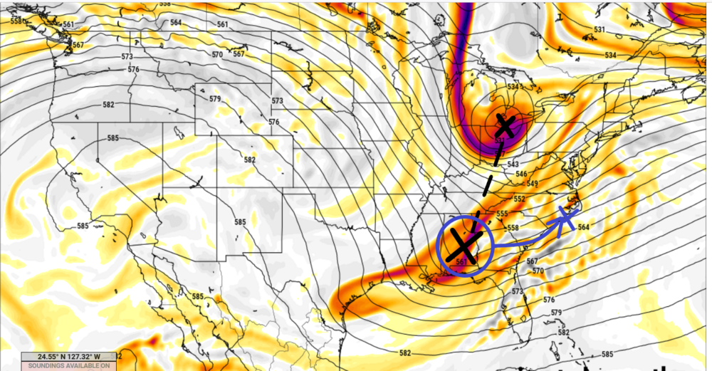
Fwiw - Chris is right ... quick and dirty annotation here to show that this is just rotated clockwise too much in the N-S total trough axis, with the N stream S/W and southern stream wave clearly identifiable. This is the 12z Euro, at 108 hrs If the blue correction were to happen in future runs, then a cyclonic rotation ( total) and capture would lead more likely to a comprehensive early season winter threat. Considering the 00z was smearing the southern stream almost entirely mooshed S toward Brownsville, and skipping the N stream through like a rock off a pond... this is a step in the right direction for enthusiast.
-
oh duh heh. Yeah trends at this range -
-
Did anyone actually see the operational Euro run from 00z last night ?
-
It's weird in way, because these southern streams waves typically enhance ...not take a way. heh. must be negative interference in this case
-
OH yeah Will - that sucker is probably heading for an entertaining solution haha
-
Yup and I'm noticing that the GFS is sort of on-off with amount of constructive interference - 'sensitivity' you mention seems related to how proficient that intermediary phase-space is, which is also in part guided by the wave strength in the atmosphere as those two interact. If the lead piece is boss, we end up 12z ish... Lag is boss, perhaps more 00z like. I mean I'm just comparing the last several cycles.
-
Supercell isn't really a part of those other 'baity' terms, though. It's a got nomenclature in physical science for being a particular thunderstorm structure that is self-perpetuating ...organizing regions into outflow and unperturbed such that they are uninterrupted in in flowing unstable air into the updraft. Typical thunderstorms are an up-down ordeal that last less than an hour, while +CAPE converts to -CAPE ...and the latter washes out the instability. "super" in the context of thunderstorm cells, prevents that 'washing' from happening. But those other terms are the present era, unscrupulous news media sources word-smithing drama terms to engender ratings, yup -
-
The surface pressure/QPF evolution is still dandy in my 'preferential' perspective. Heh. I just mean, on November 24, a 120+ hour model look like that ...I'll take it. Entertaining enough. It would have been ( and may yet be gosh forbid ) far worse if the run dump the look altogether. This still fits inside 'noise expectation.' The differences between 00z and 12z are easily correcting toward either solution. I just wonder if/when consensus hints at emerging -
-
Yeah... Thing is, it's a specter ( I've noticed - ) that began to really emerge on that transition from 12z yesterday, comparing to the ensuing 18z run ... There was a bodily shift in the total synoptic manifold of the flow structure that back-ward dug the S/W back SW along the isohypses, just enough to make one wonder if a trend was in play. 00z run comes out and it's nukey - Then the 06z backs away slightly but still delivers...now this? Seems if there is a legit signal in here, ( for one ) the models are sruggling with it - duh. But it may be that it's real but 'newish' in latching on so a few unstable runs? I guess more of a forecast philosophy of approach. but yeah, storm forming would benefit from more 00z'esque

