Typhoon Tip
Meteorologist-
Posts
41,582 -
Joined
-
Last visited
Content Type
Profiles
Blogs
Forums
American Weather
Media Demo
Store
Gallery
Everything posted by Typhoon Tip
-
86 now .. jesus. Forget 90 by 9, we're at least in the ballpark of 90 by 8
-
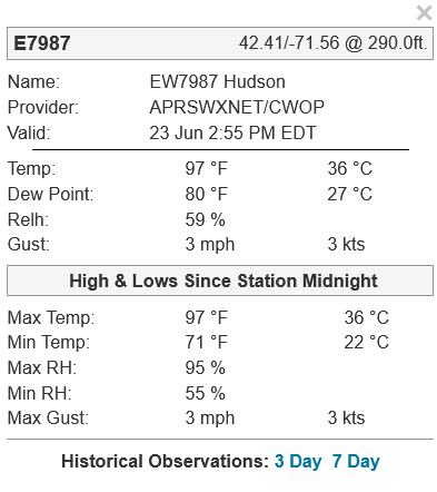
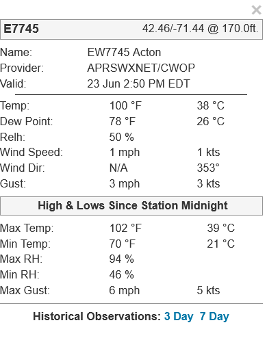
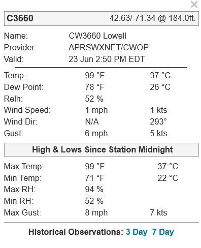
7:30 AM T 84 me thinks we don't have a problem making 100 considering it was 99 for high here yesterday, and we're still in the same predicament air mass, but today has the advantage of a loftier head start.
-
-
-
KASH 97/75
-
-
That's what makes it infuriating - it absolutely will be "in the city" ... who the fuck gives a shit whether it's that way or not at Logan's annexed seagullshitsville
-
Looks like we're at the bounce temperature... You may spike decimals and squeeze another click or even two from that but the rest temp is probably 95 or 96 regionally. I think this was above NAM MET ?
-
wondered that too but I'm thinkin' ... we shed a half dozen in DP we're definitely gain some back on the T side so does it matter . you know? 102/69 vs
-
How about a grid-wide power crisis brown down now -
-
KBAF 99/74
-
right... good point, yeah. It would be interesting if there was a "HI climate curve" - I'm sure there has to be I just curious if there's offsets
-
96/75 here
-
KORE 97/72
-
wow, Waterbury CT KMMK 41.51/-72.83 @ 102.0ft. Name: Meriden, Meriden Markham Municipal Airport Provider: ASOS/AWOS Valid: 23 Jun 12:30 PM EDT Temp: 95 °F 35 °C Dew Point: 77 °F 25 °C Relh: 56 % Wind Speed: 3 mph 3 kts Wind Dir: N/A 220° Clouds: Clear
-
The funny thing is ... this would be more difficult ( I suspect ) if it were the July 20 variety. At this time of year, "geologically" we just walked out the door from spring rains climate and our shoes are still wet. The grasses are all green and lush, and trees are all perky flopping leaves... they are just dumping evapo -tran water vapor into the ambience at a very high mass load. The idea? perhaps higher than later July when a month of summer desiccation has spend soil moisture bank account. These sources are less proficiently adding back to the air. I'm just wondering if July 20 is climate high temperature... but if the HI climate is actually a tad before that because we may get better combinations of DP with sun and source in the ends of Junes to something like July 10.
-
NAM 12z FOUS grid at Logan tomorrow, 18z 30000391714 -3499 132715 82 35 26 18 The last time I saw a vertical profile of temperatures like this ( they're in degrees C, from left to right corresponding to the 1000, 900, and 800 mb levels), was 36 hours prior to the heat wave in 1999 - which actually ... the next runs backed off. This was back when the NAM was not yet the NAM. It was it's predecessor known as the ETA. That 1000 mb T of 35 C is going to be 39 or even 40 C at the floor of the BL where explosive thermal overturning between the air and surface(s) constitutes the actual 2-meter temperature there. In lay terms ... 39 ~ 102 and 40 ~ 104
-
You know... I dunno sometimes it seems sort of self-indulgent to run AC - in my case, the mini split sys. Yeah, it'd take care of it and I'd be all comfortable but I cannot stop myself from considering the ‘physical mathematics’ of it. What's the expense. First of all, cooling the air in here asks the grid for additional energy. The high efficiency of the mini split system, notwithstanding, it's still requesting the grid to provide. Which, generates that power (ultimately) by releasing more green-house gasses. In theory, this adds heat to the surrounding ambience' unrelenting efforts to raise the temperature inside the house ... Thus, the mini split automation necessarily works harder, and in doing so ... asks the grid for more energy. And one can see where this is going - feedback loop. Now, imagine that all households that can, are, doing the same ... to mention the enormous total load requirement when thinking about the total residential and non-residential environmentally controlled environments... suddenly, this is not such a "cooked" up morality issue - it really should be. To combat this cognitive dissonance … I find myself enduring the heat as long as I possibly can. I just looked at it and 80 was the point at which bead of sweat evidenced itself … at that point I figure it becomes a health and safety priority in the here-and-now. To make up for it though … I just don’t run the cooling setting on merely pedestrian summer days that often.
-
what's the ML lapse rate ... It's not really 'wasted' to me, if there's no acceleration anyway.
-
Yeah, today's got what I call "garden site" ( basically means any site not calibrated by NWS standards) DP written all over it. You have basically still air failing to mix away exquisitely efficient evapotransporation off foilage in this heat. There's probably a DP bubble over every individual lawn for that matter.
-
it's almost like it's just sync aligning the response circuitry. ( like wtf does that mean?! haha). I mean, first the 500 mb responds. Because it is free atmosphere, ..which physically means it would respond to a heat surplussing first. etc... But, the ensuing circulation forcing then constructs/effects in the ocean patterns of wind-SS stressing. The heat aggregation regions emerge. This may look like a positive feedback? But technically it would just a response tapestry. Hard to say... there's definitely a lot of a "emergent" properties due to the immensely complex interacting forces that are also in themselves, in a state of delta. It's kind of a having thousands of 3-body problems, the result of each one, then resulting in a new 3-body problem ( metaphor). What looks like cause and effect, may in fact be more synergistic - sort of where your intimating. What I'm saying above is kind of lineary cause and effect, then casting an allusion. It's all conjecture. Part of the problem is that there really aren't discrete boundaries between these systems. The do effect one another, while also heating differentially both among themselves, but wrt one another in a "quasi" coupled way. The devil lurks in Quasi Anyway, getting into the details of how/why? good luck. But I do suspect that thermal memory, which is coherently observed in Quantum Mechanics and nature and ...basically reality, plays a role there. And I don't disagree with the notion that heat dispersion mechanics out of the tropics plays a role in wave mechanics at mid latitudes.
-
Left field thought ... .. I wonder what the local coastal estuary and beach water temperatures will be like next weekend. After these low turbulence heat/compression atmosphere days works over the surface water, while there's high solstice sun - then if we do get a light onshore wind field Thursday into Friday, that will then draw the surface bath to concentration at the shores. That top 6 to 10 foot of SST may get bootleg inflated for a time. Then just imagine... we add is some splashing of 10 year olds in 4' of water? ... the mimicry of seal bate will be off the charts. We could even set off a feeding frenzy! Heh, how apropos on this 50th anniversary week. And it's even the 4th of July next week, the same holiday weekend depicted in that film.
-
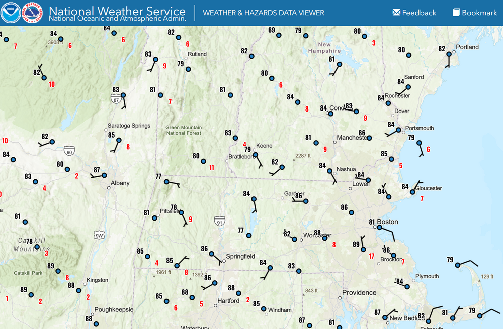
90 at KOWD at 10 (but by the time I snipped and pasted this they clicked back to 89) that appears to be the exception rather than the rule. The hottest sites are 86 to 88 but I'll give it the obs through 10:20 out of fairness to perturbation physics ( haha). I know you have Plymouth but I like this NWS product that KGRR's office hosts, too ... most are 84 however, excluding obvious inversion and/or elevations. Hot day
-
Very weak gradient in the region may spare shores by allowing the sea breeze to claim .. even some distance inland. Noticing Logan kicked around to an ESE and no heat out there... It's feeble. Doubt flags are even wobbling much west of Back Bay, but as we warm the interior that may press inland. NAM nailed that idea for BOS in the FOUS grid actually. I was wanting to geek out and test that and here we are. Wonder if we even see a bit of a breeze boundary on some rad products in the afternoon doing that thing where it's side-winding slowly inland. Anyone west of I-95 has no hope for relief. It's now 86 to 88 at most garden sites ( in between the NWS obs) and some of the NWSers like the Oxbow site on Rt 2 are already 90 - sorry read that wrong, 86, but that is typically a hotdog. Anyway, there's so little gradient we're not getting any natural ventilation.
-
86 by 9 ... not bad. Today wasn't supposed to kiss a 100's nuts anyway, but we'll also see where we are at 10. "90 by 9" ... "10 after 10" I like those two, but I've always thought that 90 by 9 sets up 10 by 10. Like if it's 90 at 10, it was bear min required, but 90 by 9 gives you the option of an aberrant alto stratus plume ( like now ...heh ) coming along and parlaying a 99.4 for a high later in the day. If you do that at 11am, and it was 90 at 10, then 10 after 10 seems more likely to fail... 97 to 99, in this very delicate, very intolerant setting or else it fails region.


