

Typhoon Tip
-
Posts
43,447 -
Joined
-
Last visited
Content Type
Profiles
Blogs
Forums
American Weather
Media Demo
Store
Gallery
Everything posted by Typhoon Tip
-
The GFS isn't even suppressed as much as it's just south by virtue of stretching everything along the x-coordinate W-E ... If the flow "geometry" is elongated, that pulls the latitude in both directions and ends up narrowing the system as well as taking it south of those guidance' that don't do that. Not sure if that is right - frankly ... I don't think that it is.
-
Right - first sentence referring to that. second sentence referring to the 'one in the nearer term' being Tuesday - I had edited that text to clarify...
-
I have the thread ready to go but I'm waiting on the Saturday's windex out of the way. I also think we are underselling the icing potential in central NE in the nearer term ( Tues ) but don't shoot me -
-
You could probably thread that out for CNE/NNE for snow mix of low to moderate impact Tuesday... higher confidence N. Granted less interest/ traffic from us down here in the southern crew, but in the interest of objective awareness spanning our large subforum..etc. That high pressure up there is in every f member of GEFs and excuse me, but long years of experience tells me that the BL resistance there is at minimum not enough and perhaps just wrong. Give the thread medium confidence, but it's worth it because Brian could end up with .35" accretion and it's only D4. I like a mid confidence thread for Friday/end of the week. Very coherent signal in all ens means implies cross-guidance support - at this range, that's pretty damn good. In fact, the existence of a winter storm over the E is backed by strong signal derived from index methodology. That's likely to be on the map. I have more confidence of that, despite the week away, than I do of icing in Lakes region of NH earlier in the week. It is unfortunately 7 day away... But, in another way of looking at it, it's only 3 days away from going from this sort of extrapolation into a better defined coherency - But you know me... when I see something I don't have much compunctions about not holding back.
-
yeah perhaps ... meanwhile, ENSO climo is under attack by a propensity and increasing one at that, for these decoupling eras ... It only obfuscates this further. I mentioned yesterday that I don't really have a feel, warm or cool, for March beyond about the 5th of the month. I don't see the EPS' veiny erection of heights over western Canada as being entirely stable in the guidance beyond the time frame. If this were January, perhaps... but we battle CC-related earlier break downs of seasonality, combined with experimental statistical inference... combine (enter plausibility) ... I could see getting next Friday... then a big one early March that sort of is like 2014 ? It was like the last thing that season did and week later we we were doing 60s with Forsythias.
-
Interesting take here from the CPC's MJO desk ... particularly that last paragraph: • The magnitude of the RMM-based MJO index has increased during early February, with an enhancement of the intraseasonal signal across the Indian Ocean. • Dynamical model MJO index forecasts depict a robust MJO event propagating eastward to the Maritime Continent during the next 2 weeks. • Based on this predicted MJO and model guidance, the South Indian Ocean is likely to remain active, with an uptick in activity also possible across the southwest Pacific by the end of February. • Given the increasing likelihood that the MJO constructively interferes with La Niña, an atmospheric response typical of La Niña is expected across the mid-latitudes of the North Pacific and North America during the latter half of February and into early March. We just spent 6 weeks in a relative decoupled state between the observed mode of circulation wrt to La Nina. Why does that necessitate we suddenly see some blissful reunited ('and it feels so good') state of affairs, now? The difference there, as written.. might be as intimated, because momentum through Phases 3 - late 6, constructively interferes with the La Nina base state... The only problem there is, that is in direct conflict with the present PNA modalities from both the GEFs and EPS sources. -EPO notwithstanding... It's like their "expectation" is/was divorced(ing) from acknowledging these current prognostic tools. Not sure how to reconcile that... Ray's got some stat-based ideas on what the pattern may offer with nuances in the ENSO etc..., that more than less 'fit' those +PNA/ vestigial -EPO modes we see coming from the EOFs. This is the interesting aspect ... IF their take above occurs, what do they anticipate the pattern to become in a more proficiently coupled state? If it couples, and Ray is right...it would only add to a amplitude that does not fit Phases 3- late 6. So everything appears to be in some sort of contradictory ...or competing conceptual circumstance. Wtf - The whole thing seems like be a bag of voodoo as Scott likes to say ... Part of the problem I have with MJO and always have, and have railed about this popsicle headache for years. THE MJO DOES NOT DRIVE THE PATTERN. The pattern may be reinforced, positively or negatively, but the MJO can exist in a given phase state and it means nothing anywhere, just as much as everywhere may look like it owes its circumstance entirely to it. Not sure how one can really tell which is which and decompose qualitatively, the amounts. The only reason I'm bringing it up and laboring through prose no one will read ... is because others keep bandying the MJO prominence...And want people to pump those breaks. We don't know what the p.o.s. is going to mean. If it couples up with La Lina and together forces a pattern, the signal can go either direction based on the positive interference...so it does pretty much nothing to clarify jack shit.
-
yeah... that's seems to be a leitmotif with the extended --> mid range ... as a 'correction tendency' this season - whether that's merely state of modeling, or something about the circulation manifold. I mentioned this myself when I first ventured the notion that this next Tuesday may in fact flatten - I was basing that entirely on what you said there ( bold ). I'm still not sold that Tuesday won't end up more icy down to southern VT/NH. I think a weaker/flatter system feeds-back that way. That's a huge load of polar high up there, and once those typical geographic feed-back barrier jets get going they're not likely to be correctly assessed for either onset timing or resistance from this range ( due to there sub synoptic grid resolution requirements blah blah ). Anyway, a flatter system has less WAA thrust, so you can get cold entrenched/dammed air to more resistant from lacking ablation. The other moving part in guidance is the that high pressure drapery up there. I'm seeing the guidance ( GFS) be quite sensitive between the cold wedge into S VT/NH, vs the strength of that high pressure. They moving in tandem run to run.. It's been like 3 mb and the CAD curvature backs just that little amount, the 32 isotherm goes 30 to 50 mi N. So, much of this colder BL thinking is predicated on that high pressure being there. If future guidance backs off signficantly/moves it off quicker to the east...fine - warm intrusion ends up CNE too. If not... not happening James. You got ice where you are, down to EEN-ASH.
-
Well...okay..but the PNA - related correction event would be prior to the March first week though. There may be lag, true - dunno. But typically those occur on the front slope of a rapid PNA recovery. But long range after March 5, mm not sure how long we hold onto a favorable look either. I guess I feel about March like I did going into Feb - I didn't/don't really have a feel for that. It may do what you suggest(ed), sure... but these present index outlooks would favor more activity between 22nd and ~ Mar 3 so some overlap.
-
That has a very spring like behavior at mid and upper levels the way it wobbles east and eventually closes off like that - almost like April '97. 12Z model take: Not convinced Tuesday is that warm, *unless the high pressure trends away from Quebec* If it does, then both the lower tropospheric boundaries can end up more N like the Euro, but also... if the high pressure lags more than means that the mid levels have more confluence up there,...which would also force the shearing S/W more S. These differences appear in the Euro vs GFS. The former is how/why the Euro does what it does, while the latter appears to be what the GFS is after. That said, the 12z GFS high pressure was trended E so... if nothing else, a reminder that a warmer Tuesday is still certainly on the table. Friday system is way the f out there in time, ... likely to modulate significantly to the point where this is almost futile to comment. That said, the PNA in the GEFs is rising very strongly through that period. It almost seems like that one is a vestige of the previous solution and not a part of the PNA rise/correction event that signals... It may be that as the PNA exerts it will transform that into either bigger in future guidance... or wiped out in lieu of another bigger deal - maybe even the one right after.
-
You... watch hour 60 for minor but real snow ... Pesky clipper taking the N route streaks into the after glow of this faux spring but real CC gut punch event, and no one's paying attention. WINDEXy and terrain enhancing could be squally from PF over to you, if the synoptic mechanics don't produce as well.
-
I don't mind windy days as long as it's 80 - gusting winds while in the 50's isn't very romantic for me. It may decimate snow this, and ruin winter delusions of perpetuity head games that... but it's a piece of shit f'ed up day that is annoying and unpleasant, being buffeted around by high winds at half the human body temperature.
-
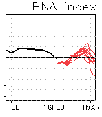
Yeah...I was just looking over indexes ... Usually, the 'recorvery' events are on the front slope of the PNA jolts... and this certainly is taking place in this reeeasonably well concerted CPC coverage:
-
Sooo... I will to stay on my anticipation for a bigger correction type event as we close out the month... Thinking after the 25th. I'm pretty sure Will and others/we've been discussing - no revelation there. Before that happens, we deal with two, PNA flat-line/modest negative index type systems, ~ Tues/We ...then Fri/Sa What interests me about them is how they are spacing so close in time, and both moving so fast? It's weird, because both have 1 ... 2 SD QPF and the atm should need longer interim recovery. ... that should be weird to people. Turning over big events at fantastic rate is like the atmosphere has rabies. But, I've been bitching and raging myself about the fast plaguing Earth going back seasons ... not shocked. I've also noticed that when it comes to d-drip seeking, questioning and/or observance of such oddities only gets in the way of actually getting the drug -lol Also, by virtue of them being large, and also being "stretched" along the x-coordinate, they take a while to transpire so it makes it seem slow. But they are moving very fast... I think one of those two systems gets us into a mix impact scenario. So long as the models are sending 1040 mb high pressures pregnant with -20 to -30 C 850 mb air masses through Quebec, I have problems with mid range tools placing warm fronts from Watertown NY to mid coast Maine. Yesterday's runs seemed to backing off that bad climate look, but overnight, they stalled. Heh. Okay... It's possible the first is too far west, and the 2nd is too far south; the models are not going to send out physically impossible solution - wouldn't be of much use if they did. At least the existence of both is in all the majors, and the ens means, to that's a good start on actually getting some some sense of continuity,and with cold of that magnitude that close, and the PNA being really more neutral than that negative, it don't know if the flow is going to bottom out so deep in the SW that these things can break physical law by going through 1050 mb f'n wall.
-
+Yep for you! ... It's the modus operandi of failing modernity. Certainly there is a vapid dearth of postmodernism (will to even question) so how can society be saved when everyone's into the orgy. There's too much 'who ever gets the information out first,' goal, and people want others to admire them ambition. Probably the natural destiny of culture that was carried on with celebrity adoration tendency, then being given tech that can disseminate egos at electronic speeds. Outright personal ambition for ooh and ahs, and dreams that follow is prooobably going to supersede that annoying slow down thing called science. ... Americans are on the narcissist spectrum somewhere ... most of western civility is, or is becoming that way. And shit, if everyone's doing it, fewer are likely to ask the insightful analytical, "healthy skeptical" checks. Just take me at face value as long as I "sound" cool and cogent - but don't mind me, I hate everybody.
-
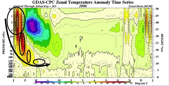
There is a warm intrusion taking place above that level, in the 5 hPa. I use the thermal metric for early detection/surmise on those - after all, they are referred to as sudden stratospheric warming event. However, since the planetary wave decaying at high altitude/latitude, is the initial event in the total SSW sequence, it's fine to use that. It is not in the 10 hPa, yet, but is modeled to do so by D10 ( from 00z this last night...). That sinking motion is absolutely everything in the total SSW consideration. The problem is, it doesn't continue to sink beneath that altitude ( at least ) in the GFS. Primer: If it does not propagate downward like this, there is a high correlation between that failure and Joe B having used it to aggrandize his celebrity, by getting his constituency to go, "ooh, ah, wow..." Here were the time-lagged, corresponding AO numbers that took place 30 days after the initial onset of the January event you see there: 2006 January -0.170; February -0.156; March; -1.604; April 0.138; May 0.156 ... I haven't looked this up, down to the discrete weekly numbers, but by these month coarse means provide by CPC, there was a clear and coherent very large negative Arctic Oscillation mode in the early spring of 2006/March. It may have, in fact, begun earlier toward the end of February that year. The Arctic Oscillation can also meander into a negative mode, without this above total planetary scaled event. So, there are examples in the database where it is both negative(positive) with no apparent downward propagating thermal wave and associated wind reversal taking place. But in every case where there is a very coherent example, the AO exhibited a marked decline in numerical phase between 20 and 30 days after the initial onset. So we'll see if that changes in the next week's worth ... 5 and 10 hPa are both showing some intense thermal flashing beginning in 5 .. actually in just 3 days ..but by D6 ... 10 begin to exhibit the warm plume. This "might" signal a propagation, however, looking ahead into 30 .. 50 and so forth, these sigma levels do not demonstrate ( modeled ) any intrusion taking place, through 360 hours. That means ( based on the GFS ), there is no current prognostic for that all important aspect to take place. Not sure what the Euro and gang thinks.
-
south correction continues on this 18z GFS run ( fwiw ). Now warning ice synoptically suggested into southern VT/NH 132 -168 hours... durational icing. Bad circumstance, because nill thaw immediately aft that event, where there'd already need watches up for the next, which brings QPF along transitions zone for ice/snow another 100 mil south... It's possible to me that this first of the two system along said range still corrects south... Unbelievable 1056 mb high pressure even more hesitant on this run... It keeps getting more massive with that feature, it gets equally more unlikely that any warm boundary gets N of NYC and probably that's generous.
-
It's annoying and unpleasant outside right now here in Ayer. There's just enough high clouds to dim the sun to a glow and not really warm feeling. Meanwhile, it's windy. So 42 may as well be 24 ... Helluva way to kick off a warm spell. heh anyway, not surprised. It didn't look "nice" out in the charts scoping this prefrontal environment. It looked to windy then.
-
That correlation may be so ... but in present practice, it makes it hard to know if that is causing this or not when as noted by CPC analysis, the atmospheric circulation has been decoupled in recent weeks. If it is decouple, that can't be the forcing mechanism - But that may be fine in the discussion. Because, it's just as plausible that eastward biased cool SST anomalies typically do disconnect/'uncouple' It's an interesting question/topic no doubt. That would take a tedious atmospheric reanalysis effort comparing all historical La Nina's that fell within 90% tolerant analogs to this one, by some red-eyed brain flogged grad student thinking they might've bitten off more than they can chew in their chosen thesis directive. I mean it's like... 'was the La Nina analog in x-y-z year' Then compare circulation modes then and now as to their uncoupled states.... I guess you could do it. But it would be too levels of research. Amassing suspect seasons, than calculations/mathematical physics to prove it. AI/super computing would be helpful in the latter. digressing - The HC stuff is speculative, btw - I only push that across ( as a posit) because I like cause and effect? I don't believe things just happen for the sake of their existence. Everything is caused by an event, or an aggregate of events in constructive(destructive) interference, in nature - in reality really. The atmosphere is no different. There's a reason for these ENSO disconnects. There's a reason for the faster than normal atmospheres. If the boreal winter heights are still deep enough, and the HC lingers into mid latitudes even fractionally... that increases gradient --> speed takes place. And here's the the thing that I think would be critical in that assertion- I don't believe the initial HC studies have it right that the expansion is only happening in the summer. That's suspect ... Firstly, the radiative forcing in the tropics doesn't dim below the threshold where the atmosphere would no longer gain diabatic energy, below 23 1/2 deg of latitude winters. It's not that it is not happening, it is being expressed via wind velocity. The compression of the heights speeds up the flow, and that is the machinery that conserves the energy of the expansion - it's just being converted into stronger winds.
-
I don't doubt Scott's data there ... I spoke about this a while ago when the RMM first began signaling a right side RMM wave momentum. However, I have a few caveats in tow. As CPC's publications noted at the time, the atmospheric circulation mode had uncoupled from the La Nina signal. I have my own hypothesis about these ENSOs and how and why they have done that a lot in recent decade. Warm or cool ENSO, both have demonstrated at times, poorer correlative behavior during the heart of the respective cold seasons hosting them. I mentioned that aspect last autumn to Ray/ et al in the ENSO thread over in the main forum space ( or perhaps here - can't recall specifically where). I posited ( and still wonder - ) if the expanding Hadley Cell phenomenon that is documented and scienced as related to the on-going CC, may be tending to supplant the forcing ability of the underlying ENSO. The way it works ( in theory -): HC expanding might go beyond and effectively engulf the the region that would otherwise/previously be the forcing interface with the westerlies. Once that happens, it does not force as readily... It's pretty simple: the expansion disconnects the ENSO forcing from R-wave dispersion. In any case, something is causing these uncoupled circulation modes. Regardless of what the universal cause is, that trend had me quite suspicious, if not suspecting, a similar observation to take place again this winter - here we are. The blizzard and the events prior to it, they were all formulated during a poorer La Nina coupled state. That said... 10 days ago we were looking at robust RMM prognostic for wave strength in the GFS cluster ( it should be noted that the ECMWF was never as robust as the GFS/GEFs were ). Risking hypocrisy, I went ahead and agreed with CPC at the time. Because the right-side RMM wave spaces are correlated well with the La Nina so well, that presence of momentum passing through might be enough constructive interference to trigger the circulation mode to re-couple. "IF" so... that would put an end to the cold loading... end to colder profile storm chances... effectively, ending winter do to it happening in mid to late February on top of an already stressing, CC-related early spring tendency - also a recurrent yearly observation. If the MJO wave is weakening ... which that present diagram now indicates ( new ), that changes that map a little ( imm abv paragraph). That doesn't offer quite as much constructive interference..
-
It all counts ... absolutely. See, it's part of the 'abstract' stuff I was hinting about. I mean, these little blockings? Those and the eventual onset of the coherent -EPO, all of it is like "prone to occur" in the hemispheric physical "foam" if you will. But prior to the actual materialization of them - the given model run is probably less important than the fact that it keeps happening - because the latter signals that it's really coming, matter of when. I've referred to this in passing turn of phrase as "super synoptic" signaling. Gets into fuzzy logic... Anyway, my experience in the past is that when this happens, the change then gets underway and it pays off faster rather than later. I don't think we are waiting until yesterday's day 11 through 15 to see activity unfold. Regarding the other bold... this week - I suggested back then - had a chance to correct S, because we had already seen a similar one do so just 10 days prior... mm, the footprint pattern isn't hugely different to assume that wouldn't redux. But I agree, this is a different kitten altogether, with these other conceptual aspects pushing against the levee of that front.
-
An impressive array of indicators unfolding as of late, that's for sure. Some of them are the traditional methods, but some are less than very easy to describe. More "abstract" interpolation, but they are all pointed in the same direction. Short: I would not count on the Euro's warm up next week (132 -168 hr ~ ). In fact, I raise possibly at this point that whole warm up is already gone - perhaps we're just in wait of seeing it physically manifest on the actual model depictions as they grudgingly capitulate. Longer: Discretely, the PNA correcting upward has not been linear. It's log over the last three nights with apparent acceleration. As of last night, the numerical layouts over at CPC have 2/3rd of the members with what would almost have to be a prelude to whopper correction event over eastern N/A for D10 - yeah...a bit sooner than we surmised yesterday. Why do I think so? More abstractly, trends originating from the different scope/dimentions. That gets into more personal speculative methods so just leave it at that... I tell you what, I don't believe the emergence of coherent -EPO, being led by quasi -EPO-like cold loading happening as a presage physical circumstance, is a less than meaningful coincidence. The hemisphere may have been morphing before our very cycle awareness. Check out the overnight GFS/GGEM with 1050 to amost 1060 mb high pressure parked over mid Quebec province? zomb! Euro's stacked more than 1040 mb along similar transit timing and position, yet this latter model shows less inhibition placing it's sfc boundary ( mean ) from BUF-N VT-ME ...uh,strikes me as vulnerable to a S correction - the fact that we are talking beyond 144 hours, notwithsanding. Despite the verification scores and/or reputation earned, the GGEM is unfortunately a very possible layout, and that solution is probably ice when then adding to it, typical BL aspects at this sort of time lead. So you have ALB in an ice storm, and ALB in a 70F ... in the operational variance. It's not impossible that we have a large scale (unsure of amplitude) ice/mix ordeal setting up from the Lakes to southern Onatrio to NNE spanning a couple days worth next week, with option S, in spite of the erstwhile expectation for huge warm up. I am also curious about a bigger, powerful type cyclogenesis somewhere in the E... perhaps 3 ... 4 days later.
-
Heh... that's like a La Nina anti-matter
-
that's the difference between cogent sounding jest vs coming off as a complete goober - just sayn'
-
Unfortunately for snow/storm enthusiasts... we'll have to wait for anything target, should anything come of it.
-
Agree ... I wasn't sure I was ever buying the season exit warm up scenario ... The EPO was falling/ neg-ish out there, and now after we've waited ... here comes a cold loading into Canada. Go wonder - The negative PNA showing up in the nearer term GEFs is not extended very far beyond, either.


