Typhoon Tip
-
Posts
43,440 -
Joined
-
Last visited
Content Type
Profiles
Blogs
Forums
American Weather
Media Demo
Store
Gallery
Everything posted by Typhoon Tip
-
purely supposition ... I would not presume this to be an EC expression year for tropical demographics - heh... even more boring than the climate signal. The battle will rage on deeper ... probably until mid Met autumn ( Oct ides-), between the subtropical/HC expansion while the La Nina failing circulation mode above mid latitudes keeps trying to pancake the flow with a shallow trough from ORD to NF. This latter stretching of the field will ensure a active recurving mode to anything nearing the Bahamas - That's more just a feeling. So, big heat. shut down. Re-hydration. shut down. TC season. Albeit rare for us anyway, shut down. It just seems there is another trend, buried in all this snark, that seems very real though. There's a tendency to keep neutering all event profiles down to the least plausible uninspired and not interesting result.
-
hope we get some water... these last three convection windows have left much to be desired, regionally. And tomorrow, looking over guidance', it appears we'll still make the mid 80s but with a return of that desiccating air mass type. DPs of 50 with d-slope additional katabatic drying, waving through fields and trees in operation water sucking life right out of the background environment... dry begets dry. I've always hated that statement, ... quite likely because it appears to be so true and it's my own petty hang-up. empirically, though, the data is what it is. Maybe just perception, I dunno. A dry period is dry so long as it stays dry or event roll out that way off the dice. And just like the crappes table, you can have successive lucky roles. Or maybe there are real physics at play. Maybe it's both - probably. Call it whatever we will, trend also is a valid prognostic philosophy. So we should go ahead and assume the drier side until such time as the erstwhile mode has quite obviously changed. When? Oh ...probably when the first synoptic nor'easter in Sept or more likely nearing Halloween - which may snow again by the way ... We'll be back to no drought condition by thanks giggedy.
-
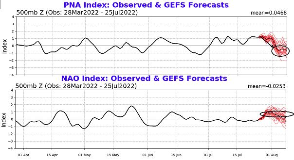
I don't believe I ever said the telecon spread 'screamed' in spirit of what that sounds like. Lol - In fact, I've been tacitly aware and bearing mention all along that teleconnectors are iffier in the summer months, particularly true with the PNA. It was the combination of them, however, with other longer termed conceptualized aspects, together, that might offer more signal in total. That's a lot of conditional baggage ( actually...) using that experimental approach. That said, yeah... the PNA corrects aggressively over the next week's worth of days. I posted the these back on pg 86 of that July thread, Other than very minor perceivably insignificant differences ...these are still essentially the same as of last night's derivatives. In fact, that continuity - thus - from the GFS ens is/has been remarkably stable. Particularly for summer. That is a highly concerted clustering around a total 1.5 (abs value) correction downward. Meanwhile, the NAO is correcting up aggressively, though not quite in the same magnitude - together that's suggestive. Basically the total thinking was/is... (still-) Iffy PNA confidence gets a bit of a nod because a positive NAO tends to lift the westerly/ambient jets, N over eastern N/A. Whereas the -PNA is a +geopotential medium over the OV, those two together carry more weight - even in the summer. The other aspect that is longer term/conceptual is that the La Nina summer correlates to a -PNA. What is interesting there in, we have not seen a very negative PNA summer. In fact, looking back along the PNA curve above, other than a 10 day stint during the first half of July, the entire summer has been in a +PNA dominated mode. As an aside, it annoys me that NCEP keeps referring to everything being in our out of constructive(destructive) interference with the La Nina base-state. Base state? The +PNA would appear to be in conflict with that assertion - we have not been in an atmospheric La Nina base state, and in fact, I would argue that the ocean and atmospheric state is largely decoupled. But... they are not very explicit beyond making the statements, so perhaps they are seeing some other metrics in making that determination re the base-state circulation mode. .. Back to the dailies... None of the above 'screams' anything. It only tips in favor of warmer departures. The operational versions are also seemingly going out of their way to correct the heat signal the moment the ridge starts to formulate. The operational GFS has been routinely a western ridge outlier compared to the ensemble mean - so there's a bit of a native inward squabble. Either the operational will concede, or the ens mean will... Or the compromise.
-
Severe Weather Threat Week...so many threats!!!
Typhoon Tip replied to weatherwiz's topic in New England
We had a strafing of showers and thunder come through this area of Massachusetts earlier this afternoon so there’s some stabilization from that -
Severe Weather Threat Week...so many threats!!!
Typhoon Tip replied to weatherwiz's topic in New England
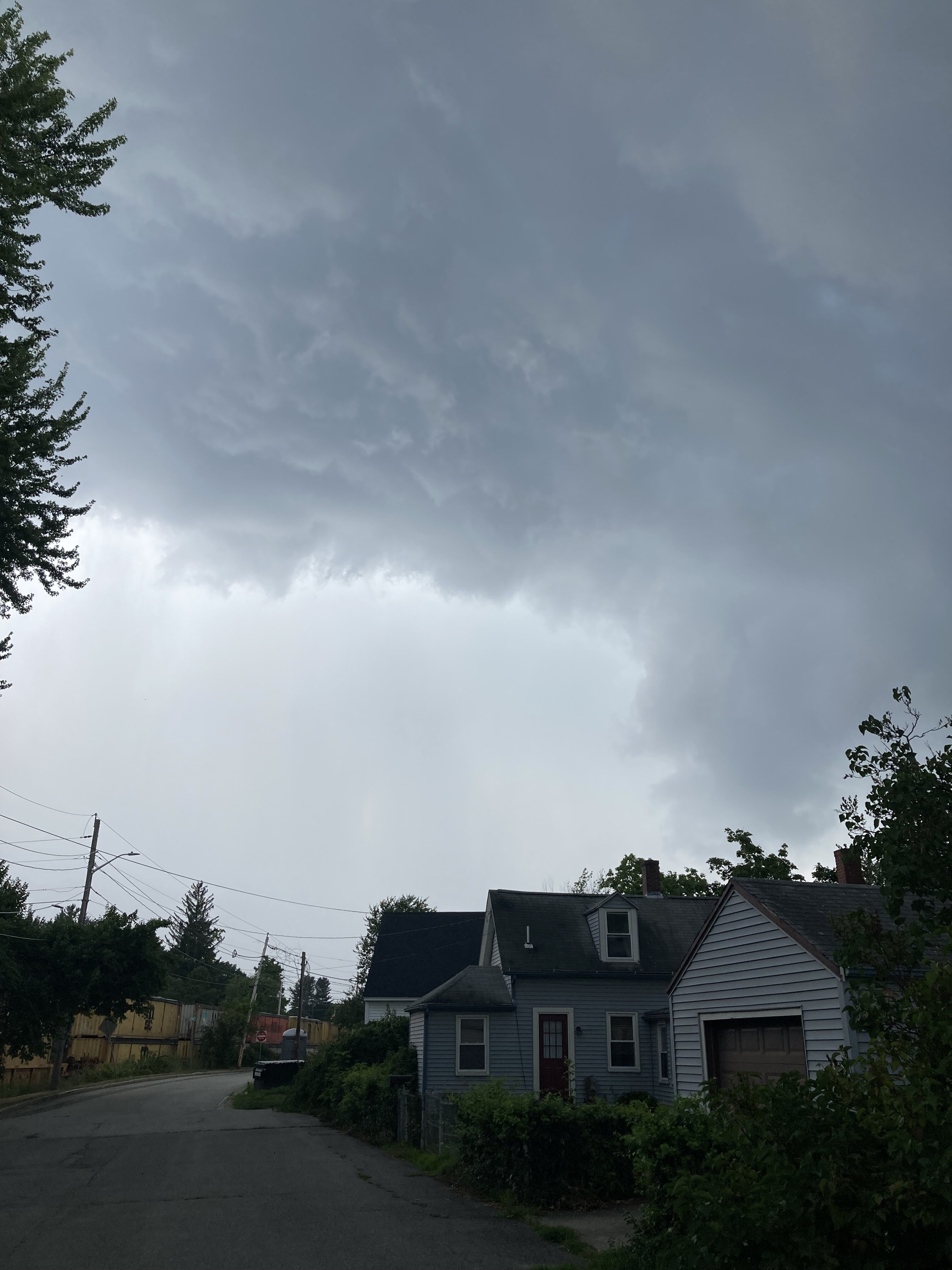
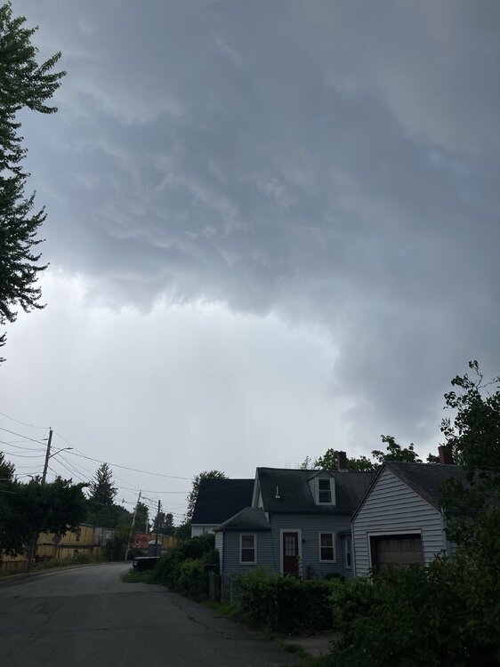
snapped these off both 20 min then 5 min prior to the brief thrashing.. The first photo(top down) those towers were glaciating but this exposure makes them look less so
-
Severe Weather Threat Week...so many threats!!!
Typhoon Tip replied to weatherwiz's topic in New England
Cell intensified right as it was passing over here in Ayer. Nice 7-10 min burst of low visibility rain. Est .4" almost immediately - it was really water boarding out there. Also 35 est wind gust. No CG but a few CC -
Severe Weather Threat Week...so many threats!!!
Typhoon Tip replied to weatherwiz's topic in New England
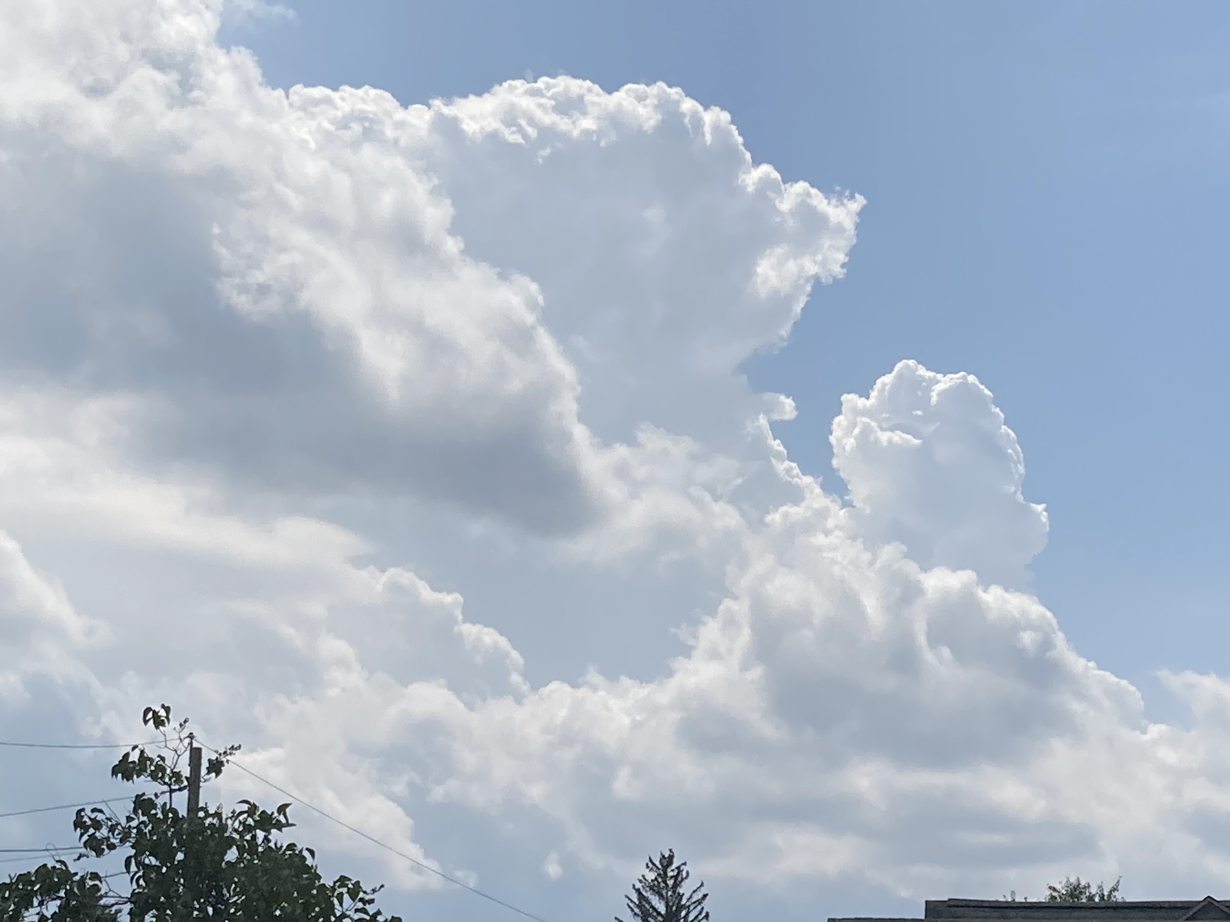
We have these cutesy crispy but narrow towers glaciating along an E... well, along the Pike and scattered about down here. It's hot man.. wow. Wasn't expecting a 90 deg day but it's 89 to 91 at all home sites within a mile or two of mi casa, and the DPs are 70 to 73. HI of 97 with crispies poking over tree top horizons is high high summer. I wonder if we can organize a cool pool wedge to come plowing into this region toward dark.. -
90/71 here ... interestingly, the HI is 97, which puts today on par with many of those days in the recent heat wave span.
-
Spring is a huge variance. It's either rectal plaque, or utopia - seldom in between... but tends to bias on the left side of that turn of phrase.
-
Meh... to each is his or her own. Fwiw - ( prolly not much ...) I find summer fascinating. Particularly because it seems to be a good time of year to see how the changing climate is really brought on the age of the 'synergistic heat wave' and also,.. changing aggricultural aspects. Forcing even species migration behaviors. It's a really good time of year for direct CC sciences not so much in and of its self, but in the collateral damages - which is where the world is entirely living, is in that space. The climate can change all it wants - doesn't mean shit if it doesn't harm. But when we have Lone Star ticks showing up in Maine ( i.e., from Texas) bearing pathogens that force the infected into a life of veganism, to Serbian climate refugees in a state of diaspora out of rapid onset drought region/causing destablization of that area of the Baltic region/geopolitical problems... I mean god, and everything in between, this is hugely fascinating. For global/environmental sciences.
-
Severe Weather Threat Week...so many threats!!!
Typhoon Tip replied to weatherwiz's topic in New England
Yeah ...I-ya, I post of mushrooms. It's the way I roll - -
Severe Weather Threat Week...so many threats!!!
Typhoon Tip replied to weatherwiz's topic in New England
Crispy towers around but they're tipping over and ripping away from their updraft sources prior to glaciation. Have seen some alto-strata altitude severed heads moving west to east over top lower/newer attempts. Sat confirms these observations/ type of sky. -
Severe Weather Threat Week...so many threats!!!
Typhoon Tip replied to weatherwiz's topic in New England
No...and that's my point, too - agreed. Expectations and education - despite our hardened enthusiasm and engagement in a "weather related forum" ( debatable some times, eh hm), we are not really well situated to have realistic expectations and/or real experience based education. So yeah... 10% chance of getting anything means there is a 90% chance you get jack-shit. It's low-yield, high impact. How does that girl that died last week at the Sebago Lake camp grounds when a big pine fell on the vehicle she was occupying, no doubt to flee the storm, feel about the fact we spent three days lampooning SPC's efforts since the last 'bust'... I'm not trying to gaslight - though it sounds that way..lol. It's we all do it. It gets boring and then we're overcome when anything happens at all - perspective fails in that circumstance. -
Severe Weather Threat Week...so many threats!!!
Typhoon Tip replied to weatherwiz's topic in New England
"tornadoes" are a tough ..because the average tornado is a pinprick over a geographic area that is so vastly large by comparison, you can't really see the tornado at the scale of the watch box its self. It has to be magnified by an order of magnitude or more to even see the debris path. But, the thunderstorm and/or aspects containing the vortext are much larger, and can be seen and/or thus experienced with more frequency at any given point, simply for occupying a greater aspect within a watch box. Still, they are much, much smaller than the total watch box geographical area, so they are still on the short likeliness of actually experiencing... Ranging up to MCS, which can be almost equal the spatial dimensions of a watch area, and pour out 70 mph wind events, behind which there are nodel DBZ cores with hail...etc.. Sometimes even tors... That's when severe watches get a bigger unilateral realization. But, then again... how often are those kind of MCS happening .. Bottom line, yeah ... probabilities are low whether the watch is marginal, or very impressively warranted, either way. It's a matter of how low in either scenario. I wonder if regional acclimation is part of it. Like, they'll issue a watch for 2% coverage potential in Maine, because they don't usually get tors...But they may opt for some specials in Oklahoma ? I dunno -
Severe Weather Threat Week...so many threats!!!
Typhoon Tip replied to weatherwiz's topic in New England
Actually ...DPs recovering more than I thought they would. Boo ya modeling...which showed 69 to 72. I keep seeing DPs getting swallowed though, reclaimed perhaps by antecedent aridity in the area. Anyway, there's some lag in SE NH/N MA where is 60s, but it is 70 toward the Pike and SW. There seems to be a diffused warm boundary in the mix here this morning... An hour ago, WPC analyzed one down near NYC but it's probably smearing across the region and losing identity. I'd say it's probably now closer to the Pike looking at obs ? -
Severe Weather Threat Week...so many threats!!!
Typhoon Tip replied to weatherwiz's topic in New England
I think today's a more impressive set up then the last, fwiw - whether it manifest convective wet dreams into reality remains to be seen. We don't hold any accountability for folks not realizing their totally realistic fantasies. But the day hosts a quasi SPV over Ontario moving E toward Quebec, and along the southern periphery of the trough there is wind acceleration at mid/u/a, with a diffused cool front to offer some convergence. More over, concomitant with said wind max there is associated a 3 to 5 dm height fall. These aspects will translate over the area during the afternoon/evening, after subtantive solar heating has boiled modest DP recoveries. This is just the orbital view. I haven't looked at any soundings and observed sfc DPs...just going with (previous guidance suggestion + a-priori)/2. That's shear appears on hi res vis loops, with early vil debris over western NY ripping E, while lower CU fractals are moving NE... so modest but in tandem with all important height falls ( signalling some improving lapse rates), working over a region ... heh not bad -
Redirect - good try... Keep at it
-
What ... y'all don't find -1 Junes in CC an interesting achievement ? Or a general +PNA recent 6 weeks of summer during a La Nina (hint, supposed to be -PNA), intriguing. This latter aspect has protected the OV/NE/MA from what really "should" have been a remarkably hot summer. These aren't multi-strobed, overlapping CG producing EOF4 tornadic supercells ending as a flip to 60" of snow... followed by a comet impact triggering a Yellowstone VEI 10 eruption forcing dogs and cats to live together... no. I get that it is a slow cook "drama" LOL...but it's still fascinating to me... This summer is running some big time anomalies, that are circumstantially unknowable to the common person ... in spooky ways, trying to like 'hide' from notice. Maybe this signal that the overnight Euro and GFS are attempting to cloak in that vein, will finally bring what this La Nina climate signal should have all along.
-
Severe Weather Threat Week...so many threats!!!
Typhoon Tip replied to weatherwiz's topic in New England
There's definitely a quasi-miss-conception about what severe "should" mean. It seems there's some lofty expectations for actually seeing severe criteria. Not this last one, but the one before...that was a huge success despite most of us in the region not seeing shit. Then, getting another watch just 3 days later or whatever that was, was also a bit unusual for us by pure climatology - people are acting jilted. The actual likelihood of experiencing severe criteria when inside a watch box is in the range of 10 or 15%. That means that in a tornado watch with an enhanced wording, you're probably not going to see a tornado - much less even criteria. Plus, there are other kinds of severe weather producing phenomenon, so each case needs to be taken individually. Like, the tor box and SC type "tends" to be right turning loner cells - those are the stingers! But that's a low yield, high impact scenario - the low yield side being the rub. That means you don't likely get to be part of the party. The storm is a tiny vessel of drama among a sea -sized region of watch coverage. The other kind is a sweeping cold pool blast back loaded by an MCS outflow which is far in a way more encompassing - if you miss that...then you may have a better gripe justification. But how often do we get bona fide MCS around here? We're really more likely to get fragmented bows off multi-cellular clusters, with the occasional SC thrown in that are mangled by the cluster f and have trouble doing much more than gating a radar scan or two... And every 50 years ... Monson or Worcester.. etc. But that kind of activity is also leaving far in a way more real estate not actually verifying any severe. It's simple odds. -
ha, that description is making me hungry for toast
-
I get the sense when looping all three of the ens mean majors, that what's going on is that yes... there is an important to perhaps major heat signal trying to emerge out there beyond D7. However, it's straddling the 'projection horizon' - beyond which the means begin to run home to the baseline climo structures - so they lose it. Like, the D7 ..8 aspects are on this side of that uncertainty horizon, and the latter aspects... the ens means lose because their collective noisy mean ends up pulling the ridge west toward the Perennial North American Pattern ( PNAP) base-line. The EPS formulates a nasty 594 dm close circumvallate that precariously nears 600, centered over the Ohio Valley... It wobbles it around there for 48-60 hours and then slowly it retrogrades toward Colorado over beyond 240 hours, en masse. That's not likely to do that at that scale and probably is a function of time and fractal accumulation among the contributing members. Canceling all forces out, we're left with the PNAP...etc. They're all doing that. In other words, this is still just too far out in time. Duh
-
It's so far out in time that these bodily shifts west and east with the ridge nodal axis has to be acceptable, too. This rendition builds it over Iowa, but like you noticed, still 850mb +22Cs skirt over SNE. Until the telecon stops concertedly correcting the PNA from +1.5 SD all the way down to .-5 SD ( total of 2 SD!) between D's 6 and 12, I'm gonna go ahead and assume that we're still in the game for major heat departures. These models sometimes do this ... They might sniff out an early long lead risk idea, then it seems it's a week of invention trying to come up with any plausible excuse not to succeed the original risk idea... Only to bring it back once they've run the gambit of failed offsets. It's more noticeable in big winter storms.. We'll see, but the telecons say not to let guard down "Still in the game" is not forecast, mind us... Just that the NAO is also rising, which is a better marker for lifting the westerlies in latitude over the EC ..so mixing PNA mode change up together tells me that these recent runs are both suspect. That and that 9 days out thing - LOL
-
Ds' 8.5 thru 10 on this GEFs mean ( 12z ) may not get us into the tallest heat ( or edges...), but it sure looks like a textbook MCS streamlining. Static WNW 500 mb flow with SW flow riding up underneath coming right out of that heat dome. It's been quite a while since we had an MCS ...and I don't count that weird wind bomb thing last October or the year before -whenever that was.
-
Not that there is any argument ... but, that was same GFS version that also tried so hard to sell 39/31, while 3+" of liquid would fall in a nor'easter earlier that March. The rain worked out, but the temperature's were 32.1/32.1 just were all winter ptype lovers 'wanted' it, but most importantly... what should happen when it's raining so hard we're under water.. The twp ends of that may seem unrelatable ..and seeing as virtually no one knows about model tooling... other than .0000000001% of humanity, it certainly is inCREdibly germane, too Lol. No, but that March, and then the latter July modeling fun above, they were both indicative of the same glaring issue in that particular version. It was really bad with lower tropospheric thermodynamics. So bad in fact it was as though the modelers left out a subroutine somewhere. Jesus, and left the lower levels unresolved right through beta and into production. Whatever the reason, it hugely effected the model's performance in multi-faceted f-up ways. It was embarrassing. It may sound kind of corny but ... the 2018 version of the GFS vs this version running now, a 110 F lala range number is still going to be more believable now. How much so... about 25% ...hahaha. Like, 2018 = 0% clue. 2022 = 25% ...and yes, that's intuitively even generous buuuut... We live in the era of synergistic heat waves, and as we've both and all have observed, we have not experienced one of those in the OV/NE/and upper MA region(s). And they gotta start somewhere... But rest assured... that still leaves 75% in this proof of concept missive that it won't do that. There are other moving aspects... I agree with the higher confidence for a warmer than normal period... I'm not seeing any issue with WPC's 80 to 90th %tile for doing so, as per their last risk assessment. Seeing as that is the case, and the synergy shit's still out there... heh. If we wind up with substantially more than 94/71, I'm not going surprised. Just trying to be open minded, but doing so based on reasons.
-
I could not scratch my head any less hard over that... that was a bust on my part. I'm not sure if that's also a feed-back (negative) from antecedent parched Earth or what, but I distinctly recall posting prior to last week that folks should consider it a 'regime change' - which did okay.. but part of that regime change was honestly an expectation for more convective rains in the area to go along with DPs. The DPs just evaporated by day and came back by night. It was routinely 75 here at dawns, and 63 with transparent CU towers in the afternoon. It's hard to erupt anything when we're ventilating all our moisture out of the column. I think I know why for that behavior but it's tl;dr who cares long