

Typhoon Tip
-
Posts
44,234 -
Joined
-
Last visited
Content Type
Profiles
Blogs
Forums
American Weather
Media Demo
Store
Gallery
Everything posted by Typhoon Tip
-
the kid can’t wait to say the word blizzard.
-
Yup... it's come back to me since earlier. We had those two back to back December years.
-
With that extended euro layout… weather we are enjoying it with snow on the ground or not with these sloped sun angles through that deep layer trajectory and overall synoptic ambience… ? Easily talkin pond skating and outdoor hockey by thanks giggity
-
It was meant for bitter sarcasm/droll humor.
-
Wasn’t there a winter back then … I want to say 2008, there was a huge December. We kept getting these Southwest flow/front loaded type 6 to 10 inch events lightly crusted over with Misty glaze. Cold air kept up winning out. Most of them were forecast to change the straight rain. Three or four of them and then some junket ones in between and we ended up with like 40 inches or something. Probably right up there with some of the Decembers of any lore.
-
Comes in 3rd place actually for my personal “where I am” static depth records. Not bad. First place was 2015. Second place was 1995. I resided in Middlesex County all three of those years … Which granted it’s a big enough space that the southern aspects tend to have less than the northern.
-
How did the Gfs ensembles do… Granted I don’t think they have any products that go out that far or are supposed to specialize in that kind of range? I don’t know no intent to detract from any other peoples accomplishments but this was suggested about three weeks ago when I was looking at stuff and I said so then I said we probably would get nailed in November course I have different methods admittedly. Anyway point is this isnt the first time the GFS ensembles seem to outperform the EPS … Seems to happen more so than it used to and I’m wondering if it’s just improvements in the model? Or maybe euros failing in recent versions
-
God I love the GFS… Lays down 6 to 10” from a flat wave on DCA on the 21st and we get jack shit … Maybe it’s warning us about the winter lol
-
Sorta half fake for us. I mean you can kinda tell by the deltas. Or rate of change. A week ago … we’d be 10:10 am at still just 41 down in the inverted layer. Now is 9:10 but outside of humans fiddling with time conventions the real deltas are moving up much slower, regardless. We were recovering some 25 deg by this time of morning before. One day I recall it went from dawn 30 to 62 by 10:40. Meanwhile the hydrostats are around 550dm over SNE …granted a bit cooler albeit briefly N. That’s not exactly “cold”. We’ve been 70F with shallower thickness than that. I’ve noticed that a lot in recent years actually. Kind of an interesting thickness imbalance in the loading between given 700-500mb layer compared to what typically occurs beneath. The above layer is warmer than expected. Not all the time .. no but we have a “half fake” cold under thickness that could be indicative of a warmer result
-
Totally fake
-
Actually … starting to get that “staged” arrival look hinted now, too. - total negative EPO and nadir of the flow in southern Canada more towards the end of next week. I mentioned this the other day… Seldom do we go directly from 70s to 30s without at least an interlude in the 50s in there and it’s possible that the first shot of cold air from Sunday into Tuesday sort of moderates into that range. 54/27..48/23 Ensembles of euro and gefs and the operational to some degree show better flex in the new pattern deeper next week So we’ll see.
-
Status quo this morning … changing of the hemispheric guard enters personnel rotation this weekend and the incoming administration has very different legislation in mind. New policy okays winter storms and even opens the reception hall as early as D 6..7 .. not sure if the guests will actually arrive - not getting much in the way of RSVPs on that. Could just be a DJ with his arms crossed talkin to the hottie maitre d’
-
Does look kinda hand drawn by a puerile high schooler huh
-
Interesting battle between climatology vs the pseudo-deterministic ensemble means of really all them. D10 off this 12z EPS for example, ... winter enthusiasts would be hard pressed to find a better construct for delivering the good, and doing so now officially entering the annual solar min months as of today. Climo still lurks... namely the lag typically claims November in head and heart aches as we know. It's that flow against SE/'Nina' residue - which ... this autumn is also placating my personal argument space ( frankly) in that the ENSO autumn is a vastly over rated aspect. Leave it at that.. If this were DJF with that look and it didn't produce ... nothing will. November has weasel out room though. We'll see if it squirms or delivers.
-
“O. I. C.” …all clear to me now
-
Multi faceted minor to moderate threat potential’s over the next 10 days to two weeks… no shortage of draws into this or related hobbies and professions. 1 .. obviously as people are aware …”Nicole”. Does she interact and gets entangled in the events over the weekend and in what form does the cyclone take… My guess is a smear as it comes up but it will enhance the overall dynamics along/ahead the pattern change/entry arriving through that time. 2 .. The nature of the pattern change itself is rather extreme considering going from possibly 75 to 80° on Thursday and then struggling to make 50 on Sunday and no hope of really getting any warmer than that for the rest of the following week. In fact I would qualify that as a cryo-supporting atmosphere but since there isn’t seasonal snow on the ground over the continents north and west of us the air mass is not conserved just yet. Nonetheless thicknesses would still support so any system that does manufacture… 3 .. I suspect the system D7-ish is real I don’t know if that’s going to affect us or not but I suspect there’s at least going to be a system formulating along the suppressed baroclinic axis W-E thru the Tennessee Valley or possibly Miller A distinction … D6 ish then a progressive system. If it clips the area … we’re watching for first synoptic white chances. … seems there’s another system trying emerge closer to the 19th in negotiation. Also within the new colder circulation type… Im incline to start a ‘low probability’ thread for the 14/15th for monitoring but I’m at work
-
18z GFS's hitting the 15-20th period ... Wouldn't hold one's breath over details... it's really more an homage to potential. It's not just the sloped flow crossing the border, but the ambient baroclinicity is going to be a powder keg with an abrupt -EPO burst loading cold in, and at least a transient +PNAP working to against the SE heights.
-
Occasional Thoughts on Climate Change
Typhoon Tip replied to donsutherland1's topic in Climate Change
“….The research spearheaded by Scott Evans, a postdoctoral researcher in the Department of Geosciences, part of the Virginia Tech College of Science, shows this earliest mass extinctionof about 80 percent of animals across this interval. "This included the loss of many different types of animals, however those whose body plans and behaviors indicate that they relied on significant amounts of oxygen seem to have been hit particularly hard," Evans said. "This suggests that the extinction event was environmentally controlled, as are all other mass extinctions in the geologic record." Evans' work was published Nov. 7 in the Proceedings of the National Academy of Sciences, a peer-reviewed journal of the National Academy of Sciences. The study was co-authored by Shuhai Xiao, also a professor in the Department of Geosciences, and several researchers led by Mary Droser from the University of California Riverside's Department of Earth and Planetary Sciences, where Evans earned his master's degree and Ph.D. "Environmental changes, such as global warming and deoxygenation events, can lead to massive extinction of animals and profound disruption and reorganization of the ecosystem,…" thank God there’s no evidence of environmental changes specifically related to global warming and/or deoxygenating and it’s all a hoax then. Phew -
Do days of averages and it might even be right back to this warm on Thursday and Friday
-
Just going from this afternoon to tomorrow morning is gonna be weird I mean it’s mid upper 70s across the area and we’re going to frost tomorrow morning probably in the interior
-
The ensemble means of all the models have been actually more encouraging than the operational versions for winter enthusiasts. a very nice scaffolding over our side of the hemisphere… So long as that is the case… we can bide time with the operational versions. Sometimes you can go in and out of a pattern like that and have nothing happen but more often something emerges eventually.
-
Order to cash in on a winter storm I mean…
-
Yeah I noticed the split. Anyway the euros been kind of volatile in that time range. I think this run is just another peregrination along the journey towards whatever is actually going to happen… But I do think whatever is going to happen is going to feature that negative EPO. And the Canadian shield’s gonna have to answer to it in terms of being cold - how much so …again is it seasonally cold, or usually anomalous? I don’t know exactly. But either way gives us a standby status we don’t need to be exceptionally cold once we get past November 15 or whatever.
-
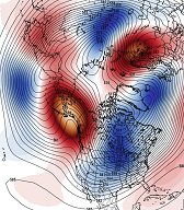
That is a weird look on the euro day 6 through 10. Exceptionally top-heavy negative -EPO/-PNA
-
Wow. Not one word of interest over that Dakotas blizzard.


