

Typhoon Tip
-
Posts
43,417 -
Joined
-
Last visited
Content Type
Profiles
Blogs
Forums
American Weather
Media Demo
Store
Gallery
Everything posted by Typhoon Tip
-
I know - I just told him that I didn't think he was necessarily denying anything. I just extended that thought a bit and apparently it was bad timing. oops. sorry.
-
No argument actually... I was thinking about the 'high end' aspect entirely when I said that. I'm aware that our averages are keeping pace even exceeding some other regions. However, I feel pretty strongly that can be explained by air mass thermodynamics. I've also mused at times in the past that nighttime lows, ...sort of like cheating us in a way lol, are the ballast of that change. It's hard to dump enough solar energy, by day, into a 42 deg N latitude even in early July, when the DPs are over 70... I mean you said so yourself with the 1930s example..etc. Throw in that we probably surplus cloud production and definitely collect a continent's worth of exhaust of other particulate gunk... and we end up more ozone rich with loftier night temperatures. It just may be the way we express CC locally... interesting. Also I am inclined to think some of New England's warming fast aspect might have something to do with it having more room to actually warm within. Similar, though a vast microcosm, to what is taking place in the arctic.. But that's speculative.
-
Wow, that 12z Euro makes it even warmer next weekend? Or fuggin shittin us! I mean, the sun will do what the clouds dictate at this time of year, but that is if anything a cleaner, broader 850 mb layout... 14.5C everywhere on a W wind ... well, sometimes color coding for nursery school is apropos ... And the funny thing is, we still are not even pushing off the mid month flip, either. That's a cold witch's tit D8+!
-
Calm down... I was speaking to the denier space - not you specifically. The deniers masquerade as skepticism but are nothing more than denying truth and reality. I''m not not merely believing what I want though? The beauty of science is ... .it is true whether one wants to believe it or not.
-
There are two answers that apply to this. 1 Yes ...how? it's mathematically proven that warm air holds more water vapor. As the planetary atmosphere has warmed over the last 30 years, vapor content has been measured to be more. That's proving the math prediction. But that is interesting in the vicinity of mechanisms that cause precipitation. Snow and rain results get heavier. And that is true in winter too - one has to understand, that winter storm snowfall is happening because there is an injection from a warm/humid source. If that source has more water, it will snow more. Viola! bigger winters/ storms. 2 climate change is not happening along a linear trajectory. What that means is... it's been accelerating. Crude model: if you have 2 heat waves during year one, you'll get 4 during year five ... 8 during year 10. That's just an example, mind you, of the acceleration. In real life, it is what ever it is, but it is not linear. That acceleration, makes it bad for a lot of obvious reasons. 1970s do not apply, because it's apples and oranges due to the being prior to a lot of the curved upward trajectory. When I hear deniers... try to supply that narrative, it irks me that it doesn't come off as skepticism. It sounds tactically divisive because the word choice and turn of phrase is clearly avoidance. That masquerades as skepticism. The current paradigm of humanity is doomed. What ever emerges on the other side will be enlightened and better off, or stopped existing.
-
Funny you say that... I use to think that it was ironic how the U.S., being like a # 1, 2 or 3 C02 footprint, isn't getting the big time SD heat bombs. Then the Pac NW happened. Still, far more frequently in Australia ...France and UK... Really haven't actually happened here over SE Canada and N of the MA. Some how we're being protected, and perhaps "enabled" ( a little) in the complacency that results when it's always news affecting somewhere else. I'm sure that'll foster some arguers ... I don't think it's been 106 at Logan for 4 days.. a two day break, before doing again another 3 days. Some truly ER filling statistical death heat. Kind of fun dystopian sci-fi idea of mine is that Gaia is doing a toad in the boiling water technique to rid its self of the scourge species. Maybe another metaphor, turning up the oven dial to clean - what we think of as a holocaust of climate is actually a purification process.
-
yesterday ...I would have said I am not surprised by today, given that synoptic overview at the time. This morning? no way. Looked like a gunk warm sector... I was thinking 70/64 - crazy enough as that is. I did not think about the DP yesterday at all. I had 2020 on the brain. oops - But this is still doing it? wtf. It's 70f'um7 here at 62. The sun is passed zenith so probably we're done .. I'm surprised we did this at this DP. I have seen it 70/70 with southerly gales, but it was swept rains and white roar through the trees out ahead of a pattern changing cold front. Lot of those in the aughts. I have never seen skirt CU with modest towers leaning with sun and nearing 80/60, on Novie 5. And to think tomorrow is no different. I'm astonished.
-
77/61 hopefully this happens in April for f's sake
-
see this is how CC expresses itself here in New England. we'd don't get the +4 SD heat events in June -August, like they have in the Pac NW, Europe or Australia's January... we get it between now and Christmas
-
No kidding ? wow. how did they get past the 2020 5 days of 80... heh
-
We might ... for a day .. day and half, but in case anyone's wondering it's not likely to be like this. Ironically, this ridge aloft is actually the penultimate - the larger planetary wave expression isn't until next week. However, the N-stream is activating across the Canadian shield, and it's confluent with what's going on.. particularly aft of this wave lifting up into Ontario later tomorrow. Likely to create an over top elephant's ass ...lobing a cheek's worth of high pressure N, it sets down over everywhere east of Chicago. So ironically it won't be as warm despite the spatial layout at mid and upper levels. When that ridging rolls out the entire mode over the hemisphere is different. Will and I were tongue-in-cheek speculating there may be a winter -like event ( talkin' mid month) around then, but it's not too far fetched - enter tl;dr reasons why here: ...
-
76/61 average all home stations within couple of miles of down town. 76 at KASH and KBED ... both with DPs similar. Gotta figure we're at or near capped...too many clouds. Tonight is really going to be something at say 10:30 pm when it may still be 70, struggling to fall while eerie wisps of translucent scud pass across the gibbous moon.
-
72/63 ... I mean, it's hiding the extraordinary aspect of what's going on. That's a helluva combination of metrics on November 5. Still may touch 75 or 76, regardless of 80, having that over DPs that high is exceptional. "thermodynamically" this is a warmer air mass at 75/62 than 2020 was at 81/44
-
I suspect it's the theta-e inject ... it's hard to get the kinetic side to rise from November sol I didn't honestly look at the DP stuff heading into this weekend, but this low cloud and terrain capping behavior is pretty classic web bulby air -related. My street's damp with no rain having fallen. Heh, in June, we'd warm enough to stop that response but in November? 2020 was dry - check that ...but I'm pretty sure that was 82/40 type ?
-
We're advecting 60+ dps over the terrain in the interior. You have strata/fog along the south coast from a different mechanism, but much of those clouds in the interior are stationary over the terrain tops. Not sure if that's gonna last the day. Feeble as the sun is...if it can add enough energy to the low levels, it will split the temp and dp and stop wet-bulbing the air mass along the hill tops. Welcome to (November + 62 dp)/2
-
No one will remember ( or care ) about the CFS's ( Complete F'n Shitshow) when it turns around in a week has a -3 sigma N/A continent -
-
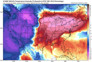
Right ...and there's kind of a quasi-connection between the "feel it out method" vs numerical inference there. We do in fact have a -EPO burst ... The models are obscuring that by the way, but I implore folks look at D1 850 mb thermal layout over Canada - that reservoir didn't manifest from no where. And all deterministic guidance show it taking over down to at least 40 N by D10. It's delivered, and doing so with basically nill solar input to offset as we're about to enter the nadir months. ... the whole thing turns into a powder keg really. You got so much baroclinic potential in the ambiance that yeah...we look for kinks in the stream. So, yeah.. in terms of methodology, there's quantifiable factorization going on, working together with pattern recognition and "music". If this were Dec already I'd probably have a thread started - I'm holding back in deference to the ugly deceptive "November 5" witch. But, if someone put up title like, "watching the 14th - 20th for season's first winter event" ... I'm sure it would get bunned by less than enlightened intellects but it would have merit. +EPO --> -EPO ... a week later, -PNA ... rises? Go ahead and ignore that when early blocking, cold and snow events have occurred with shocking increased frequency since the year 2000 ( probably some CC aspect to it, a-yup) ... and here we are. Also, the PNA is key sticking point/confusion. The index doesn't have to switch modes entirely? It just has to oscillate in the right direction to send a signal down stream... But there's a relativity to that. It can oscillate and not mean anything, but if the antecedent layout is destabilizing, ...that oscillation means everything. I also find it interesting that yesterday's AO was introducing a downward dovetail toward week 2, while the MJO has been tunneling its way through an unfavorable Pacific. You know ... maybe this La Nina starts breaking down by seasonal change exertion - that would be cool.
-
Can't get through and autumn without the models attempting at some point either outright, or hinted, fusing the Beaufort Sea with the Caribbean. I remember the GGEM like 20 years ago did this every year. 950 mb low on the Del Marva D10 from a Cat x 'cane getting sucked into a Nor'easter. God, the good ole days of modeling cinema. You younger gens missed out. Then Sandy happens 10 years later. heh -
-
heh... Folks may have thought I was 'merely' kidding when I poked fun at the notion 'by the 20th' I still wouldn't be shocked. It's out there. It's real. Whether it coalesces favorably of form from the model fog of solutions and obscuring fractals, will require time ...etc. Anyway, there is a pretty clear index modality underway. Traditionally, that is the base-line metric for ferreting out events ( regardless of significance). It begins there. You can due the determination either inference via the telecon mode vs modality, or you can just watch the fucker and feel/'sense' something is about to emerge. This latter technique is quite difficult to quantify but works just as well.. Sorry, it does - the 'fuzzy' logic approach. I think it just like how a Quarterback calculates parabolic integrals to know how and where and when to throw a foot ball ... That is really performing complex Calculus. They just don't know it. Maybe it's something like that. I'm digressing... But it's been suggestive since the last week of October. If it helps the quantity and quality argument, it's not being seen in a vacuum of reasons.
-
wow...speak of the devil. That D10 euro really would extrapolate that way... -EPO curvi-linear, high latitude flow bifurcates over Manitoba, with a definitive N-stream moving across the N of the Lakes, while the southern branch is about to trigger a Colorado Low ? Just for fun at this range, but that would be a plausible extrapolation -
-
'Sides ...isn't he the one always harping about ice storms ?
-
Mm neutral over Deadhorse is like -20 C at 850, no ? If we get into a direct transport scenario entering the solar nadir, ...I guess 'frigid' is relative to region, but that would brick the Earth and send unsupervised kids through the pond ice before Thanks Giggedy -
-
Just a handful of individual members began showing that in the 0Z Tele connector projection for both A0 and the NAO for that matter. Not enough to really sway the mean line but some of the members started collapsing out there towards the end… Boy I’ll tell you the hemisphere’s trying so hard to switch guards but it’s like fighting itself. The MJO has been unfurling in the early phase 8 and that projection really goes against cool ENSO footprint. Of course I’m not a big fan of ENSOs in the fall but we’ve already discussed that… Point is MJO between phase 7 and 2 correlate with negative AO, so it’s interesting to see the MJ struggling to hold in there with early hints from the AO
-
Holy Moses what a hammock job it is out there
-
It's been interesting monitoring the RMM over time... how this MJO wave is tunneling through an unfavorable Pacific... The GEFies have that as a moderate to strong wave penetrating early Phase 8!! It's been unfurling over time, too - that wasn't suppose to get there by Novie 7 (blw)... So, it'll be interesting if continues to bore its way across. The thing is, with the Pac/N/A look tending -EPO burst up there ( perhaps a couple of times over the next three weeks at that) ...this "might" come into a constructive interference if it keeps flirting with it.. If the wave dies by D10 like that ... perhaps not, but it's intriguing to see this behavior 'while' we are tracking the season 'possible' first winter pattern appeal (d10ish --> )


