Typhoon Tip
-
Posts
43,417 -
Joined
-
Last visited
Content Type
Profiles
Blogs
Forums
American Weather
Media Demo
Store
Gallery
Everything posted by Typhoon Tip
-
Mmm I would not sweat that solution at all seriously don’t. You can clearly see the stress of the NAO pattern structure forcing that back south as it tries to clear our longitude just like the 0Z and the 6Z predecessor solutions did too. And all of that period of time is going to be subjected to that kind of forcing - the correction vector still points South. Until there is a coherent reason to switch the direction of that vector I really see taking something significantly west of New England through the great lakes as being very dubious
-
Oh it’s no contest… Not even close. People who complain about melts are insufferable. I mean we’re being tongue-in-cheek here… Still, melts have an entertainment value. Some delicious turns a phrase can come out of people who are in a state of apoplexy. But the complainers? They are curiously disingenuous people that chastise others for melting, but are in fact melting themselves. That’s just the way they do it – and it’s actually technically a form of gaslighting too. They don’t want to face they're own failing so they defer to targeting others and vent that way.
-
We can laugh at this is buuut … it is quite right and just about perfect as an early risk assessment. we’ve been talking about the run up to mid month for about 10 days at this point. I mean it’s not just what was in the models there’s other techniques of a personal nature coming from me but other people have been on it too for their own whatever they do. And for winter enthusiast, it is unfortunately a slight chance - but you know …that’s gonna be true whenever we’re talking about a 10 day outlook and this is really 11 12 and 13. I think we’re also kind of in a cultural adjustment when it comes to the technology because the models are so much vastly better we’ve gotten used to expecting certain signals to really manifest at extended leads. But Jesus the 13th to the 15th is still over 10 days away
-
Yeeeeah I would not count on the MJO helping out much until further notice. It’s really in a destructive interference with the footprint of the Pacific. One thing folks need to understand about the MJO it does not force the pattern; it augments the pattern if/when the pattern is receptive. Otherwise it doesn’t augment shit. Crass way to put it but it either adds or subtracts from an ongoing pattern via constructive vs destructive interference. All of the left side RMM wave phase spaces are destructive until further notice … which is why we keep seeing the wave collapse into the COD region abruptly as it tries to enter phase 8 from 7? That’s the footprint of the Pacific canceling out the MJO, and thus its ability to influence the pattern goes right along with it.
-
Utter chaos coming from every guidance source overnight… both within their own performance envelopes but relative to one another. The blocking in the hemisphere is the only consistency … but morphologies in how it integrates with the surrounding circulation medium, from forcing to feedbacks, … is/has been different from run to run. If the PAC has “improved” it is what it is but it’s also “new” and represents a mottled continuity … Better looking doesn’t necessarily add too predictive skill - just sayn Oh man. I don’t know this is the first time I’ve seen blocking grow so ominously large that it threatens some kind of cascade thermal inversion that engulfs everywhere and is spooky in the Sci Fi sense of it LOL 06z oper GFS shows the 12.13.14 aspect but it’s hard to even tell if that’s the same or just coincidentally timed peregrination of the next variable run or what that is. The GGEM’s exotic solution is really 7.8.9 getting stuck in -NAO amber … almost a vague analog to the ‘100 hour storm’ but that entire option obliterated any system planning at all in lieu of what that’s doing. Looks less like it logistics out there and much more like it’s just numerical instability in doing something at all underneath the NAO block’s baroclinic petri potential. It’s just so volatile. Retrograde plus east component plus the Coriolis parameter creates a little red spot. … It’s actually kind of cool. Heh Just looking at the individual members of the GEFs it still looks like a run up to mid month has a chance to be a significant player over the eastern conus. The one in the foreground around the eighth to the 10th I think the models will not stop until they actually tap the Metaverse
-
Oh I see. It’s really just doing what the 12z did but even worse. That would be a first time in history if the NAO actually behaved that way and maybe there’s something tied to global warming and CC with that I don’t know I’ve never seen a model be so hell-bent on doing something that’s pretty much never been seen. Do it seems.
-
I was just looking at the 18z GFS loop at TT. given that frame size … you almost get the impression there’s no -NAO at all … im too tired to look at this further. I’m getting close to whocaresville but I wouldn’t be shocked if it’s just moved the blocking en masse again
-
how can they tank the NAO any further, jesus. If that ridge builds any taller the Artemis missions may as well be scrubbed because astronauts could just step from the top of that doom right upon the surface of the moon
-
Glad you look at the individual members… Don’t be shy about doing that with the GEFS members either. People need to get in the habit of doing that. What’s the harm in doing it if people want to see the modeling cinema. They got 31 different movies going simultaneously…haha. there are some GEFS members with monster solutions near in the Dell Marva to Long Island and in fact the recent trend from the blended mean is showing steadily lowering heights in that area on the 14th which and I have been talking about that period for five days so I have no problem with it.
-
It’s not a bad take. Really … other than the specter of the block itself, there’s really some exceptionally bad model continuity right now - really rather stunningly poor. I think the draw on the eyes toward the -NAO might even be masking that. It’s still the more important responsibility, that these models show modicum of clue but even the day fours have been a little bit dicey… so as that day is in the approximate 9 to 14 or 16 range we may be still dealing with some of that
-
Nah he’s right. I was screwing up the time intervals.
-
Not sure the following statement will really resonate given the mood and the people of this particular Internet depot… But Saturday still looks like it’s gonna be really nice - may be one of the last days to get out for an outdoor run or hike or bike ride for quite some time afterwards. Unless one is hardy and doesn’t mind doing that kind of stuff in less amicable weather
-
Just a thought… But yesterday those rumors floating around that the new version of the GFS system was somehow corrupting the assimilation data - maybe Chris knows something about that? but the thought is that since I’m pretty sure the Canadians purchase a lot of ingest data from the GFS grids maybe they’re being affected by that. A lot of supposition there but worth a question. Maybe the relationships are all different now
-
I don’t disagree with any of that in principle but I suspect … if we want to drill down into the psychobabble aspect, there is a little bit of mmm I don’t wanna use the word dependency, but there is a kind of thrill-seeking addiction that happens. I’m not gaslighting the group here by any means. I’m really not. Hell I’m part of it. But as an honest attempt at an objective observation, it is affecting us here like it affects everyone in society - to some degree We’ve turned the model releases times into kind of a cinema that provided that thrill:rush. I mean sometimes it’s all but coherent that we want the model runs before the storm more than the actual storm itself lol. And if the cinema isn’t showing that finishing scene, that gives emotion and ‘emptiness’. - endorphin loss there. That’s why we’ve been joking about drugs and Narcan and all this other shit …we all know it’s true. It’s part of the stuff they been talking about on the news and the documentaries about how addictive the Internet has become. You know… As a totally separate subject matter it’s been used influentially as a manipulation and divisive tactic. One of the reasons why society has so much polarization right now and the sword of schismatic cultural belief systems that are hateful. And hate to use the trope but they are tearing up the fabric… Etc. It’s actually really interesting subject matter. If people are interested check out the ‘dystopimentary’ “The Social Dilemma”. The last I knew it was on Netflix but I don’t know if they’re carrying that anymore. But they have been like 60 minutes exposes on this and other infoshows are surfacing
-
If it makes anybody feel any better it’s below normal today…
-
Again again again… The NAO is notoriously stochastic in guidance handling. The fact that this one’s been behaving doing better over the last week or so is really an anomaly in itself we’ve been lucky up to this point not to be dealing with that but you know?
-
And just to be funnin’ …I actually wouldn’t mind that position in a scalar sense of it if we could just lop about 30 or 40 dam off the top of that sucker
-
Oh it’s even worse… I mean after two weeks of build up that should’ve gone the other direction then do that? It’s even worse because at least in the other since you did get some snow at some point. I guess just since we’re being silly here… the upshot is that that happens on the 13th and 14th and there’s plenty of time to manufacture something in the recovery period after - assuming there will be one.
-
The GFS at 12 Z offers yet another option… Completely remove any effect of the NAO exertion …allowing 13.14.15 to Grinch through the Lakes. you know the recurrence of that kind of phenomenon is getting more and more difficult as the years go by to believe it’s purely random lol No but I’m not sure this model run really fits the mode of what’s going on here. I’d probably give this run a lower probability of success
-
The observations would suggest so… Yeah. Keeping in mind this is relative to predictive measurability and using what ‘s given. I mean the pattern could collapse into a compressed velocity soaked meat grinder and we could still end up getting something out of it - it’s just not modeled at the time. Those reach around more typically minoring events would also go quite far in saving the spirits in here lol. But at this range really we just have to try and sift down to the main nuggets of influence out there in the pattern. It seems the NAO is handling stable and it is the Pacific is the one that’s acting like the unattended firehose flopping around in the model runs Will said it in a nice concise manner just then - a communication art I typically fail at … But if you just stick to that as a basic canvas requirement everything that I mentioning about the NAO this morning becomes rather academic. It’s just that it matters presently as we try to sniff out events because that fundamental aspect seems to be dictating our success right now in dealing with modeling noise I feel pretty confident in the perturbation out there 12.13.14 but it’s really unclear whether it’s gonna get constructive feedback or destructive feedback and I think most of that sensitivity again is centered in what the PNAP is going to do
-
The PNA is the mass field that’s demonstrating the greater variability during this era of outlook projections. Interesting. It’s interesting because there’s been a pattern of more vs less sensible impact east of 100W in either the operational, or the ensemble mean, when/if they take turn bulging more or less +PNA/+PNAP respectively. In other words … the sensitivity over whether we produce or fail over the next weeks of this thing appears to be mainly of Pacific origin. Strange to see the NAO of all stochastic pain in the neck indices be so shoulder rubbing stable.
-
Meh … punching the clock as we labor through model runs that vacillate between constructive vs destructive interference. Yesterday constructed Overnight more than less destructed If it need be said, 7.8.9 is still beyond D 6 (fairly…), implying as it should that it may trend back colder - NNE is part of this sub forum … etc. While 13.14.15 is still yet beyond the ‘operational event horizon’. Of the two intervals 13.14.15, despite being beyond predictive usefulness…, has the better conceptualized chances, however … con I’m still toying with: the question of an overly compressed flow over mid latitude dominating the NAO continent is still unanswered. We conjecture that there’s likely to be at least some of that … agreed. But there’s virtually 0 assessment possible from this range whether that becomes too inhibitory during. The models are good … probably best at telling us which impulses could be interesting, if they are allowed to do so. But are particularly lousy in the “if” area beyond that ‘predictive event horizon’ above. I’ve been discussing for years that the NAO presumption is a bit off a false read … probably left over from the early popularization while not fully knowing the true nature of the index’ implication spectrum if the 1990s. It’s the D(index) with a steady diet of non interference Pac wave entry from the west that enthusiasts want … Just keeping my own expectations in check for now.
-
I’m pretty sure 1888 wound up in a frontal structure similar to that.
-
I don’t know what if any significance this is, probably nothing beyond symbolic, but this might be the first time this autumn I’ve heard turbine gusts from actual CAA
-
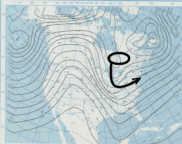
Noticed that ... The key is the aft regiom of the ORD S/W...If that pops taller into Canada ... it will trigger that western SPV to curl and subsume - that's a 1978 redux look there, but is hardly claiming analog - just the 'behavior' in principle... This GFS solution doesn't get it done ..but it's damn close!