

Typhoon Tip
-
Posts
43,417 -
Joined
-
Last visited
Content Type
Profiles
Blogs
Forums
American Weather
Media Demo
Store
Gallery
Everything posted by Typhoon Tip
-
What would you be holding him to? That structure is unlikely...so there's no purpose are method for testing whether it would rain or not - so it's good that you won't hold him to it.
-
Yeah six/dozen or half of another ... It's a fence enough look
-
Preliminarily ... a medium impact partial Miller B, Friday
Typhoon Tip replied to Typhoon Tip's topic in New England
Dilemma ... It's both true. The bold, and that fact that it has 300 years of climate backed inference to suggest a cyclone should not move headlong into a -NAO blocking with being shunted E. -
See I kinda lean the other way, ...I'd call it a cutter pattern with the possibility of stretching the field ..which can lead to fun shit that way. But the -EPO look with limited counterbalancing -NAO ( this time around...) and a "La Nina -based +PNA" wants to dump chunk troughing into 100W which...as we know, would put ST L to Michigan in the telecon cross hairs. The difference that "might" be useful to winter enthusiasts back east is that the flow probably resumes a faster base-line state... That has a tendency to fiddle with wave lengths in interesting ways as much as it can be hostile - either direction. There's a loud signal in the 20-24th period... Let's see how it starts emerge in the deterministics.... Heh, it's not that long away. 7 days it's the 20th..
-
I would characterize the 12 Z GGEM solution as a uniquely ‘exotic bomb’ gotta love the GGEM imagination model. Lol. That’s a rare yard-stick storm from DC to Maine So there’s definitely a bright signal between the 20th and 24th, but it’s so far off that it’s very difficult to determine how it will express itself. For example… a mode change into a positive PNA doesn’t necessarily translate to the same kind of N/A as it would during an El Nino. I mentioned that because … we happen to be in a very well coupled La Niña base state so in deference to that, we have to consider the variance. I could see this all evolving more midwest and being a cutter unfortunately. Plenty of time… I mean like the present storm shouldn’t be going this close to Logan Airport anyway by climate inference and it’s probably going to do that so well hell
-
Preliminarily ... a medium impact partial Miller B, Friday
Typhoon Tip replied to Typhoon Tip's topic in New England
Unusual large scale synoptic evolution in having such a large vortex anomaly centered over Michigan (~) while a -NAO flex takes place over the western limb ... is not doing the models any favors. This is down to small scale differences, but the differences between the GEFs and EPS (GEPs) are on either side of the proverbial fence. The 00z/06z GEF blend would almost undoubtedly flip the interior to a period of moderate steady snow once applying marginality with the fact that the 850 mb stays < 0C .. This isn't true for the EPS and GEPs... SO, ...it's a 2 to 1 contest at 90 hours of approximate lead. Standard convention holds that we lean toward the consensus...which would lend to the Euro-like notion cold rain after a quick intro of snow/mix. However, the climatology of NAO ...particularly those expressing over the western limb such as this, is that these things correct S. So there's plenty of reasons not to 86 the GEFs/GFS solutions...which by the way, are quite tightly knotted as of 06z version, with very limited/no spread at 90 hours taking a moderate cyclone response between CC and the BM. ...that "tight clustering" aspect makes it weird - In either case, this still looks as though the better snow shot is along the axis outlined in the beginning of this thread to me. Maybe erode that back NW a little in a Euro solution... But **IF** the 06z -like idea of the GFS wins this... the relative error with 850s less that 0C and height falls and +PP situated N, probably sees an interior snow-rain-snow scenario with greater accumulation concerns. I tell you though ... a simple SE movement by the Euro of very little synoptic spacing would go a long way toward making more sense with the NAO. But the 'unusual' big vortex over the Lakes ...may just make this be a comically rare scenario. -
Preliminarily ... a medium impact partial Miller B, Friday
Typhoon Tip replied to Typhoon Tip's topic in New England
And the nam was actually northwest of the previous run. NAM’s likely to be left if other guidance beyond 48 hrs -
There is a signal emerging for the 20th thru the 24th. I’m sure by now somebody’s mentioned it…? If nothing else I agree. Want to talk about it further once we got around to the storm thread - so that maybe we can have a place to focus the near term. Lol maybe we should start a new December thread like part II
-
Preliminarily ... a medium impact partial Miller B, Friday
Typhoon Tip replied to Typhoon Tip's topic in New England
That’s not a bad interpretation … no. I noticed the 18 z GFS backed of intensity a little - the low ends up more E. It’s probably related. It’s negatively tilted Its likely slowing as it attempts to move past. Those would tend produce by virtue of maximizing mechanics over duration … But we don’t want it to get so weak that it doesn’t matter. It all to comes down to what ejects out of the trough as it’s moving through the Midwest and starts smearing out under the block. I don’t believe the models are really going to have a very good handle on that until maybe tomorrow night. Seems like more could be delivered given the size and depth of that beast, though… which could conserve more of that momentum by winding it up in a stronger lead short wave injection for example. -
Preliminarily ... a medium impact partial Miller B, Friday
Typhoon Tip posted a topic in New England
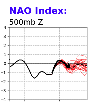
Obviously we are all aware ... this has been out there for 10 days at this point. This is also a bit of a continuation over the thread now scrolled that began coverage as a risk assessment this week. It's stuck around and here we go. The question, what? There are 2 aspects that are in conflict, and I suspect that has manifested in these large scale synoptic fluctuations that have occurred, sometimes upon single run cycles, over the past week. Not just as it pertains to this storm, but the entirety of the circulation. 1 .. a well-coupled La Nina base state with the Pacific and how it influences the behavior of the PNA --> PNAP this autumn is notable. 2 .. Asynchronous to that basal flow tendency, we are seeing an obscene amount of blocking over all quadrants of the polar hemisphere. The tandem of those two disparate forcing pretty much puts us exactly where we've been with this system, uncertainty that ranges from a major to minor impacts, or what can be imagined in between. Yet, 'some' kind of any event has persisted through those modulations. In the end, this ... combined with a this ... tends to produce. That and the persistence for an event at all, lends confidence in an event - above normal. There's a huge amount of uncertain as to what form the storm will really take. My feeling is that a moderate commitment to Miller B will be forced E of a European guidance track. I am paying particular attention to that regression in the NAO you see after 4 days from now ( curved line annotated on that graph is kind of ugly...).. That's important. There is a precedence this recent two week of blocking for 'pulsing' in both the EPO and NAO domains. The behavior you see there has some trended merit, and there in is the tricky part. There is in fact Baffin Isle/regional -NAO pulsation, as this storm will be riding toward our latitudes. That does not teleconnect to storms going W of Logan. Can it happen? Yup. Is it likely? Less so... I'm thinking this is not a major event, but is the first one that offers a synoptic snow threat ... Preliminary for that would be briefly N-W of PHL... perhaps longer as it moves N, N-W up the I-95 corridor ... NW of HFD-ASH has the best shot for snow. Should this need to be adjusted E over this week, don't be surprised.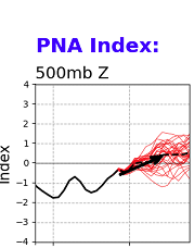
-
It’s a great question… my first impulse would be to say yes because of the nature of the hemisphere being in a blocky regime. We are in a climatologically favored location for slow downs, stalls, and exotic types of retrograde behavior in general, during times of blocking. however there is a conflict with the basal state of the hemisphere and the La Niña - particularly this ladder factor is of importance because the hemisphere appears to actually be coupled to the La Niña basal state. that conflict in principle is probably related to why we saw the models with unusual stuff going on over the last week. Model performance is rarely held accountable beyond day six without a degree of incredulity (ha), anyway. But there have been some really rather extraordinary large mass fields movements across modeling cycles over the past week that have been hard to predict and rather unexpected even considering that. Anyway… it’s not abundantly clear that the slowing tendency of the blocking hemisphere will be able to operate without some influence from the other aspect. I’m inclined to think that we are losing a big closed vortex going underneath our latitude because of that … but the circulation medium still has a lot of mechanics that have to resolve its way through and it’s not going to go through the block. Therein fits taking the compromise - which is often the course of lesser regret in these conflicting scenarios Right/for now I’m leaning on a moderate impact scenario by our climatological standards moving somewhat slower than we’ve seen in recent year storm budget, with profiles probably a little colder than what we’re seeing now. That “moderate” may be open to some subjective interpretation understood
-
Will check your messages
-
It’s not model noise. Too many parametrics are leaning the other way and that’s all it’s doing is just responding to those as we get closer if those were not the case and they weren’t leaning so to speak… then it probably would be model noise
-
I’d say east before I would say ‘92? I suppose it could happen… But from right now and only having 4 1/2 days it the entire Vortx structure’s not likely going to evolve under our latitude like it did in 1992. However we can eject enough shortwave mechanics out underneath the NAO block that would likely slow down… quasI closes off. It’d do a winter fun that way
-
This is not true actually it was incrementally east between 96 and 84 hours comparing those frames to the 0Z run … Circumstance that was also true while the system is making its direct impact But it doesn’t matter… it’s the same as the 00z. The 500 mbar evolution was also slightly southeast around the southern and southeastern aspect of the isohypses layout, just enough yet I realize you’re hoping for the opposite to be true but I’m just using your post to point that out. Overall the guidance at 12 Z is continuing along the expectation laid out earlier that this is probably the beginning of the end of the western press and at the runs going forward will probably start to respond to the scenario with the NAO block exertion … specifically being that it’s a western limb structure being important in this, too
-
I’m glad you’re spending the time to look at the numerical NAO coverage first of all… More should adopt that habit. My take: it’s actually the time right after that which is kind of hinted in that curve… The spatial version demos that during that time range, it actually begins to manifest a new transient blocking node in the lower D straight area over ne Quebec and so forth… that’s a critical behavior. -the domain space is rather large. Yeah. But that’s precisely what’s going on The entire spatial area partially masks the significance of that block because it may only be numerically equivalent to that small depth that you see out there between day five and six and seven on that graph. However, that’s an important factor in where the cyclone goes once it’s knocking on the door of our latitude.
-
It should change aspects in your mind because it’s going to try turn colder over the course of the system; and I don’t mean trend in the models. I mean the system itself is going to differentiate towards a colder profile …moving slow enough that’s going to change things in the aft aspects of the event. FWIW I mean I am speaking in specifically from my perspective on this; we’ll see how it goes. In fact if the models trend east and clobber the interior I would not be shocked at all. Well relatively clobbered ha ha ha I mean it could just be like 10 inches of 9 to 1 ratio blue bomb which by the way December’s good climo fit month. Just sayn. Folks are in a negative mood and it may be harder to think open minded. From where I’m sitting this thing has a colder lean written all over it. it’s just a matter whether it happens or not to me. See …my kind of crazy is that I care more about the storm in space and time rather whether it rains or snows. it helps lol. I won’t lie, I’d like it to snow. Yup. I think the event and everything else has been a marvelous success here which doesn’t mean anything to winter enthusiast if it doesn’t snow. I get it
-
… I feel pretty strongly that we are seeing some E corrections now and going forward, not withstanding how subtle or gross…, for the philosophy and concepts that I discussed yesterday regarding this being ‘pressed against the western solution wall’ considering the physical/larger synoptic manifold
-
For the general audience… We really can’t consider this a D4 event because of its slow movement and likely profile differential that occurs over the course of the event - it’s more likely the ballast of it As far as what it means to the user ship in here…is late on D4 into 5. I’m just discussing the timetables there entirely.
-
haven't seen any posts since about pg 157 ... I would pay attention to the d(model) between 00z and 06z wrt the GFS. I don't believe that is a non-significant and/or mere nuanced storm placement and thermal profile modulation ...i.e., 'noise' between solutions? no - 06z is a marginal atmosphere at a 4.5 to 6D lead, in a -NAO... with and antecedent polar high in no hurry to leave the 60w/50n ~ feed source... and the 850 mb isotherm, as was depicted...gets to about HFD- ASH before collapse. All of which never really had a very good climate inferential purpose for going so far W over recent runs to begin with? - If one doesn't get what a 'correction vector' is, and in this case ...which way it points, I dunno what to tell you man. If that whole thing is machine emerged hallucination to begin with it ...okay, but, excluding that possibility ( sarcasm intended...), I don't think that 00z to 06z changes were noise. They fit the above baser metrical layout and the theoretical, and experiential/historical, forcing arguments. Not to be early sold... the 00z to 06z GEF mean also bodily shifted east some 100 naut miles. The 00z Euro also looked colder and more compressed SE with the thermal profile...despite attempting a similar cyclone track as previous ... I find that as suspect telling. There was a modest east jog in the EPS mean from 00z comparing the 12z. These matter for this overall circumstance, more so (imho) than the average case, due to these colder arguments leaning on this thing the way they do.
-
actually ...I think you are backward on this analysis. The point to point comparison looks like the 00z was more E
-
It's a whole different world up there ... There was a store downtown up there, back in the 1980s that used to specialize in family crests ...don't know if they still exist anymore. But we went up there to purvey... When we left the day was a grayish hang, with moist 39 F air over moosh snow. ( Acton, MA)... By the time got up there it was in the mid 20s, with 24" of powder. I stood there about 5 or 10 minutes after sunset, with T's slipping toward 20, as the arctic night claimed the last bit of blue nw horizon light. The Presidential Range ( I think it was ...) created a dark wall beneath the sky along the left side, and there were some other elevations on the right. ...This made the allusion to a hallway. And every 3 or so minutes, out of nowhere ...the wind would rise from near calm to fill the air with blowing snow...fulled through the valley floor. It was just pure winter - 0 adulterated pureness. It's a moment in time that is indelible in memory... And I thought about that as returned later that evening, and it was the same old 37 F stale air over a rotting snow pack.
-
I knew it would do that ... I haven't seen it yet, but I suspect you are right just because of 'why' I thought it would do so. Ha. seriously though. The stuff I was talking about more of a L/W whole-scale move (toward) the guidance, as opposed to a 'tumbler' trough would tend to offset the W position lows that materialize nearing the coast. The sad part is...the tumbler would have been the best if it could stay south. Will and I, and others ...were musing at the party last night that the runs yesterday were sort of leaning that way - it was impressive... But, alas it didn't last. Anyway, better of the loss is to have it this way - so lucky in that regard. You know...I still have a problem with the whole evolution of this period in question. The -NAO appears to move out at the convenience of the trough moving into Ontario,... but it can also happen that way. There plenty of precedence and real personal experience, however, with blocks being dismantled too quickly, or handled improperly by mid range modeling. Something else that suddenly occurred to me ... It's almost like I'm getting sick of this f'n thing and can't wait for it to just be in the rear view mirror. lol
-
...like a long bike ride from it, anyway. Yeah - weird
-
It may not be the worse thing to happen for winter enthusiasts ... ( yes, everybody), should this thing evolvw more into a L/W as opposed to quasi closed 'tumbler' - The reason is, it opens the door for a lot of possibilities. The previous construct/evolution portended one bigger-ish event, then done. Pattern shuts down with some sort of 10 day "recharge" requirement. But the L/W version offers renewing possibilities for impulses to be delivered into an ambient cold/baroclinically charged domain. It also at a large hemispheric scale, move toward more of a +PNAP ( if rooted in +PNA), evolution. The -EPO joins the discussion here, folks. I wonder if it is under the awareness radar for the forum, but that's a huge cold signal showing up over James Bay to Manitoba... It's been there for a while in the runs. This 12z GFS is close to seeing up a mechanism to deliver this either in segments or en masse - "close" ...it's hinted there. But the D7-11 elongates matters at mid levels. It's a fascinating attempt to evolve this in he guidance, but there are possibilities that it ends up favorable, even if Friday/Saturday ends up a progressive moderate event. The VT 20+" is likely model magnification, "UNLESS" some changes do recommit to more being ejected with that lead S/W there.


