

Typhoon Tip
-
Posts
43,417 -
Joined
-
Last visited
Content Type
Profiles
Blogs
Forums
American Weather
Media Demo
Store
Gallery
Everything posted by Typhoon Tip
-
You're angry - ...I think an autistic child would gather that at this point. hahaha. My work here is complete
-
So who are you directing this toward - or is this just for the general audience. Who the f thinks CC is driving the forecast models. The advents are happening in a warmer environment. That's my contribution - just for the record, there is no connection to performance of machinery/guidance, at least not implied in making any statement I have made. So hopefully your statement is/was directed somewhere else -
-
Hot head, ... good luck
-
This is simply not true. There is fingerprints of climate change everywhere - that is not me. Reality is obsessed with reality, and there those that cannot accept it. Because to do so, means their methods are not right - largely so... That's what's going on here behind these turn of phrases. So yeah...typical tact, pot shot and make it a personal abasement, then ...redirect to another thread. Crass - and it won't work You are wrong. And I am right. sorry
-
It's not always about you friend I think it is cherish-able that you get to be a father, and congratulations - but ...you can also keep your climate resentment - if not coveted denial - as a compartmentilized effort. If you succeed in doing that, it won't bother you that I was talking to Scott.
-
You know ... I've been thinking about that DP thing. I almost wonder if that's going to be how most of our CC expression tends to behave/express in our summer climates of the future. As this inevitable change ( if not crisis) continues onward into the future ... it seems we have been reporting elevated nocturnal temperatures here more so than the other side of the diurnals - we have above normal afternoons..sure, but in terms of standard deviation, the night times throughout the eastern OV MA and NE regions seems owned by the lows. In a conceptual sense that makes sense actually. We are an exit point in an increasingly cT summer realm...so we live and breath and measure in a cloud of continental farts... It's hard to add enough solar heating to a 76 F DP, and still get the temperature too crazy in the afternoons at our latitude. That heat wave we had around the 4th of July in 2017 may have been our first synergistic heat wave ( Pac NW, just the way we express it...) I recall DPs one day in that stretch were 79 F, at 2pm at 94 F (averaged local unofficial home sites within a short clicks of my location) ... If we'd have done that 67 F, the air T might have made 105... speculation. But, the shorter version, I sense that we just get warmer and wetter here as a climate response, where as places like the Pac NW or the SW... or even the Dakotas, where they have less miasma, that's where they get those buck10+
-
won't matter ... you'll have your phone or what ever maxi tech pad.
-
hm I'll check in later if a late snow total update is needed... otherwise I'm checking out on this thread/event -
-
Anyway... Ptype rads have me over to snow now but it's still raining. Temp is up to 32.7 too - Helluva finish... LOL Just being a little snarky there but it's true. These 5 min obs are trying to do a kind of exit face smack on phase 1 of this event. It's like that scene in "Air Plane", when Leslie Neilson's character halts like it's an afterthought, turns back around, just so he can get one last smack in on the panicking passenger before heading back to cockpit - Phase 1 hesitates much in the same way. hahaha
-
heh.. we should probably take this to a climate thread; we seem to be collecting buns in here LOL
-
Essentially ...yeah. I've started noticing about 7 years ago ( prior to the 2015 spike anomaly freak) ..that began being the case, as you intimate 'more often than not' I started referring to it as our "flop direction" ... I mean if we're entering an event that is for all intents and purposes, even money as to whether it'll end up white or wet in the guidance and too close to have a lot of confidence either direction, we don't end up white as often. It's like the "marginal threshold" is moving up the EC ... We might have escaped the Marginal- and crossed into the NJ marginal+ It's possible it is a subtle distinction of CC reported through event behavior.
-
I get the impression looking at rad trends like this phase 2 might be oversold a bit for this afternoon. Guess we'll have to now cast our way to either glory, or falling back to seasonal trend of ever diminishing returns ... which this latter has about a 10-0 record ...
-
I cannot help but feel like last night would have been more of a snow transitioning to ice thing rather than a snow to 32.4 one, for the larger part of the interior eastern SNE region (... say N of the Pike/ W of 495) if this were 30 years ago - given the same synoptic footprint. Our winds here in N Middlesex CO have increased since 4 am, from the NNE, from a region of 30 F ... yet the temperature continues to rise. This is most likely from conduction as it's pretty damn warm at 850. The tucking flow at the bottom is not sufficient to compensate. interesting. there are strange events that take place while no one is looking, aspects that hearken to changing times.
-
1.5" ... so far. We'll see later on. 32.5 12" on the season
-
So what’s the verdict on the rain snow line versus modeling-I wouldn’t mind hearing from some Mets, too?
-
18z GFS has a thunder snow storm over Springfield Ma at 15z tomorrow - how's this for "bundamentalism"
-
18z NAM was colder ...sure that's been covered -
-
It's about perfect with what I put in. I had 5-7" in the max axis .. but a couple of 9er's here or there is certainly within error.
-
There's a spread suggestion for something over the first week of February.
-
that's the needle thread track sensitivity incarnate. The 06z GFS and the 12z tracks vs that snow axis -
-
oh ...this has to be a set up - way too easy.
-
...wtf does that mean... the other guidance looks like ass, but the GFS has always looked like ass. So.. .yeah, ass looks like ass. hahaha. It's funny though, this sort of reminds me of how 52 F in July is "crazy" cold and people shiver and wear jackets... but if that happens in January under tepid sun and no wind? - short sleeve shirts and gaiety posts of dopamine ... It's all conditioning. We've just been conditioned to eating so much shit this winter, here we have a less shitty look that offers mash potatoes - maybe - still likely falling short of "climatological storm profiles" (for this time of year/region) and it is like the short sleeve shirt scenario.
-
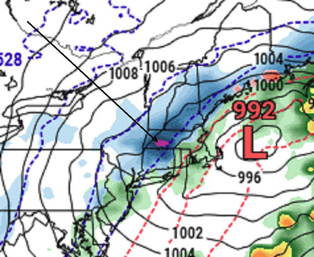
Okay ... in this lecture, ladies and gentlemen, we target Great Snow 1717 for migraine headache. See if you can identify the exact moment the temple sends a shard of pain behind the eye sockets - Here is the NAM's FOUS grid for Logan off the 12z run ( on right is Laguardia, but ignore that block for the purposes of this pain administration - ) BOS//792733 00513 232405 34999299 LGA//663346 00515 232106 39029500 06000773458 01415 212109 38019600 06000714265 02119 201808 41039800 12003989055 00514 171407 41010095 12007988855 02113 140808 46040200 18032989365 00409 090711 46040400 18039989357 10804 040515 51050702 24057986523 -0208 980325 49040402 24022975905 -1108 003414 45030500 30025987105 16308 953516 39000098 30008969302 04804 013115 31029995 36046978619 02909 003123 30009793 36004726812 00110 083122 28019693 42002783110 -1813 083022 32999694 The data fields I bold'ed above are associated to Phase II, tomorrow into tomorrow evening, and these numeric values are important. The "25" and "46" on the left, are QPF... That is .71" liquid equivalence occurring as of 36 hours from 12z this morning, the time of the NAM run cycle. The fields on the far right, ex "0000098" are the temperatures in C at 980, 900, and 800 mb levels. 00 = 0C. 98 = -2 C. So you can see... the next interval is 009793, which correspond to 0C, -3C, and -7C at those respective levels. I think this is in process of still modulating in the guidance however.. .The reason I suggest that is because of those middle values, "35" and "31" - those correspond to wind direction. 35 = 350 deg around the dial starting from N ( 0 deg/360 deg). And so 31 = 310 deg and so on. Here's the thing, typically you don't get bigger QPF numbers on wind directions that have backed that far into a W direction. When you see a NW wind with QPF, that is part of the notorious ANA fake-out effect. And, I can tell you from experience, the NAM has no compunctions about lying big numbers with drying flow ( ). However, since this entire solution is more so trending toward more reliable guidance types ( Euro and ..whatever, they're all better than this model at handling synoptic anything), I would not be surprised if the next cycle has more of a 01 of 02... offering NNE trajectory that fit matters better. So, this immediate abv paragraph is just offering some reasoning why we may not want to shed the NAM's .7" snow burst tomorrow. I also like the fact that at 18 hours ... .32 has fallen with a +4, +4, 0C column. Once you get NW of the city... that could be +1, +1, -1 say FIT -ASH... that's your bust axis for Phase 1
-
Not to poke the hornet's nest but this sorta feels like a 'when does the dam break' scenario. We keep seeing these models edging the big deal, and falling short ...but the next series seems to look a little closer to doing that - ... maybe they'll fight to hold back the inevitable right into now-cast when Springfield Mass is in 1/4 mi vis 5::1 pillows falling or something like that... Talking phase 1. I mean I'm not forecasting that, but like Will being spooked about positive busts... it does kinda sorta head scratch a last minute cave. Phase 2 tomorrow, I've never been a fan of the old backlash - too many sorted memories of TV mets in the 1980s. However, it occurs to me that this situation isn't quite a backlash scenario. What is actually happening ( synoptic evolution ) is that the models are early in triggering a "main low" along the baroclinic axis as it cross the NJ shore and races by the Islands... The mid level ( 700 to 400 mb) jet mechanics are actually still way the hell and gone back SW ...and as that intense max wind core torpedos by ( 2deg lat S of the Pike and right on climate btw!), physics take over and column goes unstable over the top of a near fully saturated column. The resulting UVM is over a large area because all of that is spatially largely taking place aloft. And thus establishes cyclonic curvature ... back along/under the N exit-entrance relay of the jet maxing. In other words, that's not a backlash scenario. I don't know what we call that... it's like a smeared out coastal that is trying (the models) to disconnect the WAA phase from a more proper Norwegian cyclone model cross-section. Thank you - I enjoyed typing this ... despite not many understanding wtf it means. Back to the original sentiment. Phase 1 and 2 being sort of separate chapters in this story, I could picture both just finally going colder. It seems the correction vectoring has been pointed there and these runs are holding back that weight. So this part is less analytic and more angels on shoulders I guess.
-
yeah, ..just trying to raise awareness - we may be a bit rusty on these environmental feed-back headaches. I'm wonder if some of the 'rain' along Rt 2 converts to ZR prior to the column collapse snow burst tomorrow afternoon, and that could creep down eastern flank of Worcester/Watchusetts spine


