

Typhoon Tip
-
Posts
43,327 -
Joined
-
Last visited
Content Type
Profiles
Blogs
Forums
American Weather
Media Demo
Store
Gallery
Everything posted by Typhoon Tip
-
January 2026 regional war/obs/disco thread
Typhoon Tip replied to Baroclinic Zone's topic in New England
Looking more and more like the Miami rule's behaving for the 15th but it's the western ridge that's that's a problem. Too far W ... It's sort causing the trough components to dangle through the Lake/OV instead of digging. So we end up with the b-c axis with paltry wave running up along it instead of the bigger woofer. It may actually work out that way - which would probably drive winter storm enthusiasts to something barely restraining apoplexy ... haha. I mean with all do empathy ... you may never see 6" of wind whipping NEster again, huh That PNA ridge was biased west much of last winter. interesting anyway. -
January 2026 regional war/obs/disco thread
Typhoon Tip replied to Baroclinic Zone's topic in New England
Trick in that solution will be whether there's a pulse of sufficiently low enough DPs loading into NYS-VT-NH ... even if we can get that down to say ALB-EEN-MHT that may be close enough. There's a front coming through around 00z Saturday and between 3- 9Z overnight there's CAA albeit not aggressive. I wouldn't normally comment on a marginal set up like that for ZR, just because it's a fragile set up and it's got 60 to 72 hours to go... however, there's a distinct rising PP across upstate NY-ME and it's nosing around the terrain and bowing the isobars into a dammed look...That means like today, a sneaky ageo flow is susceptible of getting going - if/when coming out of even a -1C DP source that's good for ice at least down to the border towns. edit I see NAM cute pink paint is indeed into interior even down here. CNE obviously higher odds -
Hey Don - you might find this interesting ... https://phys.org/news/2026-01-north-pacific-winter-storm-tracks.html ...statements in there that speak pretty specifically relating to the increasing temperature tendencies/'why' amid the Southwestern regions of the conus.
-
January 2026 regional war/obs/disco thread
Typhoon Tip replied to Baroclinic Zone's topic in New England
https://phys.org/news/2026-01-north-pacific-winter-storm-tracks.html "The findings add to a series of Chemke's previous studies pointing to a troubling pattern: Earth's storm tracks are changing rapidly, and climate models don't always account for that." No shit ... i missed my calling. -
January 2026 regional war/obs/disco thread
Typhoon Tip replied to Baroclinic Zone's topic in New England
HAHA ... man, the ICON is setting up just a delicious bi-polar American WX Forum experience for the 15th, huh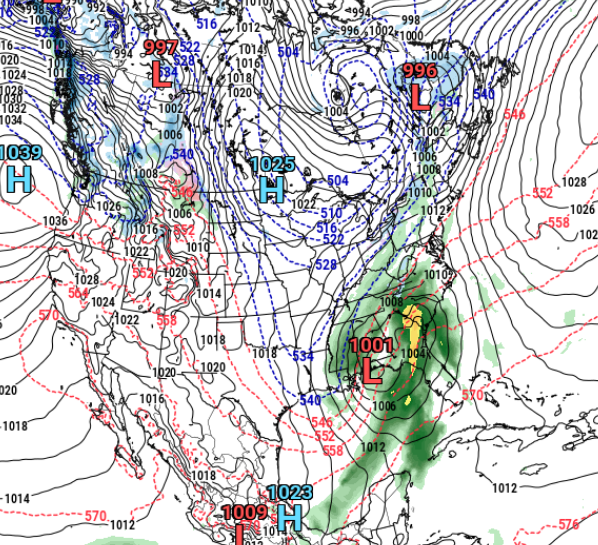
-
January 2026 regional war/obs/disco thread
Typhoon Tip replied to Baroclinic Zone's topic in New England
yeah...it's not hugely obvious I guess. But, I also don't remember the daily charts looking that ideal, either. I recall distinctly that it was S of that some of the time. Also, I'm kinda more interested in the "stuck resonance" behavior too. It was really something. Other notable was how the MJO was squashed out of existence that whole time too because the two negatively interfered and the N. Pac was daddy. Tentative proof of that ... the resonance decays and summarily the RMM has/is released/ing the beast. -
January 2026 regional war/obs/disco thread
Typhoon Tip replied to Baroclinic Zone's topic in New England
I tact this onto to the end of that missive as "plausible" explanation. As an afterthought ... might look at the W Pacific warm eddy ... the Pacific resonant pattern of the first 1/3 of winter was suspiciously well placed downstream of that feature, where physics would want an atmospheric response. Just sayn' The Pac warm eddy is new to history. This resonant thing was also ... "new ish" to history. And geo-physically fits in a spatial distribution sense of it. It's an idea -
January 2026 regional war/obs/disco thread
Typhoon Tip replied to Baroclinic Zone's topic in New England
The point - poorly conveyed by me .. heh - is that the typically causality for -WPO and -EPO responses were not likely what drove that N. Pacific resonant pattern. Therefore, it is not likely that anyone really saw that coming. The silly "tsking" is not meant to trigger you. It's just that assessing what's going on without qualitative analysis is inherently risky in general. -
January 2026 regional war/obs/disco thread
Typhoon Tip replied to Baroclinic Zone's topic in New England
To me it was all more than that. ...the entire hemispheric layout was not anticipated. That's what it means to be 'highly anomalous' but semantics aside. That was not a canonical WPO ... it was a freak scenario that weighted the WPO and EPO ( oscillatory) down just because the ridge meandered some over a 4 week period, but that whole circumstance was something else. Proper -WPOs are situated closer to the Siberia/NW Pacific. The EPO is closer to Alaska... That thing was centered over the dateline, slightly S of WPO latitudes, but was just enormous enough to pull on the index domains Numerology of the indexes, without qualitative analysis? tsk tsk As an afterthought ... might look at the W Pacific warm eddy ... the Pacific resonant pattern of the first 1/3 of winter was suspiciously well placed downstream of that feature, where physics would want an atmospheric response. Just sayn' -
January 2026 regional war/obs/disco thread
Typhoon Tip replied to Baroclinic Zone's topic in New England
Whatever happens with the temperatures tomorrow and Friday, Saturday looks suspect to me. That looks like meso-low/'tuck' times. We are at the eastern end of a warm boundary that is pinned along or S of L.I., with +D(PP) moving across QUE, with damming already nosing down to the Pike like that? good luck. Might even end up being another ZR issue with that. -
January 2026 regional war/obs/disco thread
Typhoon Tip replied to Baroclinic Zone's topic in New England
Actually the MET was 50 at FIT for tomorrow off the 00z output. I'm surprised a MOS product was that high. -
January 2026 regional war/obs/disco thread
Typhoon Tip replied to Baroclinic Zone's topic in New England
I think it's a temperature nerd's first day - call it a "warm up" for the impending MOS bust season. lol -
January 2026 regional war/obs/disco thread
Typhoon Tip replied to Baroclinic Zone's topic in New England
yeah, I'm just referencing the NAM RH levels. Haven't looked at other guidance, but 18z had < 50% over Logan, which is typically sun soaked. It may be cloudier western areas, sooner. Plus, it's the NAM for period 4 -
January 2026 regional war/obs/disco thread
Typhoon Tip replied to Baroclinic Zone's topic in New England
wow. Not intending to troll the timing here but ... I was just looking at the 12z NAM grid. If those numbers are right for Friday, we're going above MOS and probably human interpretation on that day. It's too early in the returning insolation to expect much assist, but +8C at 900 mb would send the temperature to 72F if this were mid February. Don't know about January 9th... proooobably not. Gossamer snow pack will prevent some recovery, too. If that NAM thermal profile is right, ton of midday sun and light WSW wind will be interesting for the temperature nerds like me. -
January 2026 regional war/obs/disco thread
Typhoon Tip replied to Baroclinic Zone's topic in New England
Yeah, that's the unfortunate Miller A trade off... the pattern foot doesn't come with that. The 50/50 thing is the Miller B or variant thereof. It's need for it circulates cold into the antecedent environment ...typically waiting to the last second to then scoot out of the way and make room for the coastal coming. Miller A's tend to be progressive. Heck they're really more like needle thread storms, their just arriving from a steeper azimuth. The difference is, since they are coming from a huge heat and moisture source, they tend to just be bigger and by default affecting a larger area. But they do tend to be progressive for lacking blocking vortex in the Maritime of Canada. -
January 2026 regional war/obs/disco thread
Typhoon Tip replied to Baroclinic Zone's topic in New England
Yeah, tomorrow has a soupcon of being a nape day ... It's hard to do that in January, because the sun's just too darn feeble. Need to breach the solar transition entry times ( first week of Feb) and then the affect is much more noticeable. Otherwise, feeble west wind at +5C in the 980 MB level on the NAM grid, with < 30% RH in the cloud column is going to feel pretty amazing to those that don't suffer the negative SAD form of that disorder. haha. Anyway acclimation/seasonal relativity is going to make that 48F stroll across parking lots, while the sun's feeble warmth is still warm nonetheless, feel even warmer and more invigorating. -
January 2026 regional war/obs/disco thread
Typhoon Tip replied to Baroclinic Zone's topic in New England
this would have been an "ice storm" opportunity if the fall rates were more - tho could argue the length of the event is challenged, too. There's an established drain/ageo flow ongoing that is just about perfectly balanced against melt layer overrunning aloft. We're glazed to perhaps .1" ... shrub and twigs starting to do that day glow look. Car windows are mottled and there's icicles forming along the edge of the awnings. But the puddles in the salted streets are barely patterning rings. Rad is a bit more robust coming, moving in from the west but it may not last long. -
January 2026 regional war/obs/disco thread
Typhoon Tip replied to Baroclinic Zone's topic in New England
EPS member mean has a Miller B behavior, albeit centered around 1000 mb give or take .. but the pressure pattern evolution is unmistakable from 200+ hours of way this is a fine signal. The 06z GFS as others have already pointed out was a canonical looking system. It's Miller A. The earlier 00z was amplified at the L/W scales, consistent with the erstwhile +PNA outlook/timing, but devoid of S/W mechanics capable of doing much of anything. The GEFs have a low passing through but it's unimpressive; again, not too concerned with that at 200 hours - plenty of time there. The 00z Canadian and any Canadian run for that matter going back several cycles have yet to do so either. The GEPs mean was a subtle improvement over the 12z run. These are all like 'taking a stab' at what 14-15-16 will be. Best not to commit to any one of these signal variances. The take away is that the signal is still there.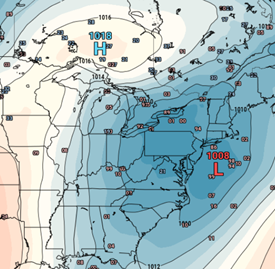
-
January 2026 regional war/obs/disco thread
Typhoon Tip replied to Baroclinic Zone's topic in New England
Not sure what the semantic registry is on your side, but going from not a positive PNA to a positive PNA is a regime change Now, if you’re talking about whether it is going to provide this that or the other thing …who knows The other thing is that PNA may not last that long because there will be another regime chain shortly thereafter- if the extended range multi ensemble sourced indicators play out the way they look now. We’ll go to a negative EPO “regime“ -
January 2026 regional war/obs/disco thread
Typhoon Tip replied to Baroclinic Zone's topic in New England
In fact, this 18z GFS run came in with a trough deep enough to get it done for the first time in this approach, but ... the wave spacing of the individual S/W's are interfering. -
January 2026 regional war/obs/disco thread
Typhoon Tip replied to Baroclinic Zone's topic in New England
Heh... pistol to head I'm more inclined to suggest the 13-16th based upon science of mass field modulation and correction ... The period after that isn't 'bad' per se, but honestly... we slip the +PNA and then see a new pattern signal right on it's heals that is an abrupt blossoming of a bona fide negative EPO ( not that weird N. Pac thing last month) ... I'm just referring to the actual spatial construct of the hemisphere in the deeper ranged ens system, all three agreeing in principle. The problem with that is, we could observe a seesaw in the pattern just the same ... a flip back "warm" ( ish ) in the E. There's a spatial synoptic argument for it. It shows up statistically/climatology on negative EPOs where a fair number of them actually drop heights in the W immediately downstream of the Alaskan sector ridge. A variation that wouldn't likely be sussed out at this range necessarily. I actually think in the winter where we have established cold on this side of the hemisphere, the flow rate will encourage lengthening L/W lengths ...that might offset the tucked west scenario, too. So some help perhaps That all said, I don't see that as encouraging as this rather powerful looking +PNA burst that is happening in the foreground ... It starts ramping earlier actually... late this week, and maxes around or just prior to the 15th... Usually it is along or near the apex, we engender a bomb or a series with aggregate energy. The operationals have a kind of 'correction vector' that is pointed toward amplitude when there is such a loud signal, yet they are lacking. This signal predates their typical extended stochastic bs.
-
January 2026 regional war/obs/disco thread
Typhoon Tip replied to Baroclinic Zone's topic in New England
Yeah, I know ... Lipid panel will improve ...that was the point there ... typing fast -
January 2026 regional war/obs/disco thread
Typhoon Tip replied to Baroclinic Zone's topic in New England
Cut out all processed sugar as much as retentively possible. I mean you gotta go at it with remorseless vengeance and assume with distrust in your heart that whatever, where ever, and why, are all conspiring to sneak it past your attention. Everything about food stock provided by the "Industrial Food Complex" since the early part of last century is reconstructing sugar molecules. Stay on the outside of the grocery store perimeters. Only by raw and cook your own. NO EXCEPTIONS! Go Allulose and Stevia extract ( organic sources), about 96/4 mixtures if you have to have sweet. A teaspoon of honey is probably okay ( but that doesn't mean 20 of them either). The former tastes exactly like the toxicity with 0 toxicity. You won't know the difference and it has zero glycemic index. Sugar beyond the biological evolutionary signal ( an amount that is shockingly lower than people are aware) is connected to 90% of all inflammatory responses in physiology, and just about all systemic problems traditionally associated to 'just aging' are in fact connected to different degrees of inflammatory response. What's actually aging is the body's ability to resist the toxins of access sugar. Easily fix.. Gout and other forms of arthritic flares, to hypertension to pre Diabetes and eventually arteriosclerosis and cancers ... all can be traced back to inflammation. You'll lose weight. Your cholesterol will plummet ( particularly the tri-glics and ultra LDLs). You'll notice a reduction in frequency and intensity of maintenance areas of the body. Hell, you might even recover some -
January 2026 regional war/obs/disco thread
Typhoon Tip replied to Baroclinic Zone's topic in New England
Ha... essentially, winter in the northern hemisphere is in or around this circle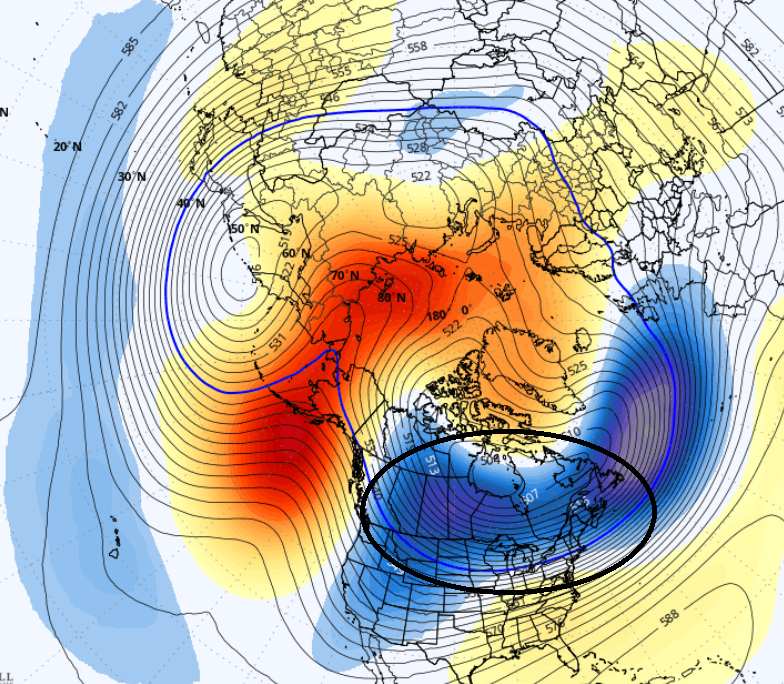
-
January 2026 regional war/obs/disco thread
Typhoon Tip replied to Baroclinic Zone's topic in New England
yeah, I see some boat missing by those making an "analysis" of these 12z guidance.... haha. The Euro was really close .. really really close to going bonkers with that Jan 15 thing, which was a massive step toward amplitude comparing the prior run. The CMC also moved significantly toward a deeper +PNA with coastal implications heavily flirted. I dunno. From this range? I call that plenty to look at.

