Typhoon Tip
-
Posts
43,850 -
Joined
-
Last visited
Content Type
Profiles
Blogs
Forums
American Weather
Media Demo
Store
Gallery
Everything posted by Typhoon Tip
-
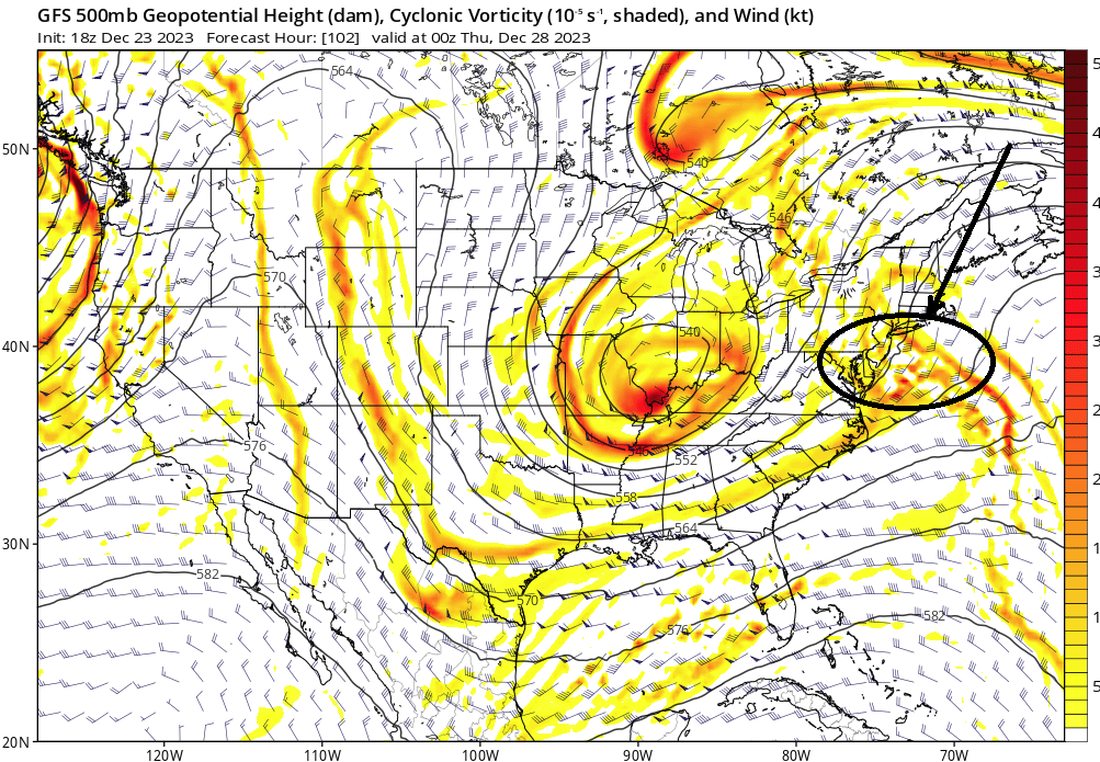
6 hours later and eastern NE is getting utterly destroyed by this whaling blizzard...
-
-
It was poorly worded because I ( of all people LOL ) was getting sick of writing at the moment. I meant he's good at some things and has managed to amass extraordinary wealth along the way. Sticking his self-righteous position into anything he chooses, because he is wealthy enough to do so as he pleases, is bad. I don't condone Twitter myself - no. Never have. Don't have an account, at behest of others too. Never will. I find it to be a glaring example of the dumbing down of general population - the plebeian echelons don't realize ( unwittingly so..) just how damaging that sort of pap on tap is to their mentality. They are being held in place by the great pacification - ... and the beauty of that is, when you don't use your mind, you lose your mind. That's true of any system in the nature of organic life. You know... it really is wonderful fodder for the cyber-punk, Sci Fi sub-genre as cinema or literature. Probably already been done at least indirectly with plots like the "Matrix" or maybe "1984" etc. In our reality, they are being dumbed down to inactive involvement by convenience and the addling dazzle of the display. And the more and more these kind of "lights" get turned on to fill the darkness of their ignorance, they become programmed to the bidding of corporation. That's a the book blurb right there - anyone wanna start turning phrases? We even experience something like that in here. We are completely obsessing and evacuating our time looking for some kind of joy fix we get from this preoccupation with weather models-turned into entertainment cinema. The gift of unstoppable human intelligence would be much much better served, honored, and capable, if people would learn how the f* this stuff works, instead. It's idealistic. Perhaps heavy-handed in some sense, too. And of course implying a virtuosity as a failure is always a touchy aspect - gets people triggered ( obvious psycho-babble tropes as to why). But the truth is, when we don't use our minds, we lose our minds.
-
Right ... the antithesis to how a warm pattern tends to promote BJs.
-
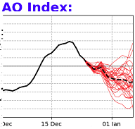
I'm very much agreeing on two aspects above: - the pattern changing may not pay out as the hopefuls want. I'm looking at this with guarded optimism... I'm with y'all. I certainly enjoy the big winter experience. However, trying to be objective ... there are too many examples of poorly performing longer term air, and/or air-sea coupled teleconnectors in recent years to ignore. Be it, the ENSO phases have observed as uncoupling at times. EPO's not lasting as long in any given negative phase state(positive), because the flow speed is causing unusual RW instability ... The machinery of the system is different ( leave it at that), enough so to not be as confident in any given intraseasonal pattern variance/projection. Having said all that... the AO projection has trended negative at CPC in recent days. Lot of spread, but every member in said spread is negative. The mean looks pretty depressed. So ... if the +PNA decays ... and then we see a new -EPO onset to reset the relay cycle/relationship between those two domain spaces, while the AO is negative, that's actually converging telecons maybe enough to overcome the above tendencies of lower performance. - X needs to go away. Elan Musk is doing great things for humanity - his sacking of that enterprise is not one of them.
-
If/when a Sudden SW intrusion takes place ... down-welling behavior is a tightly correlated aspect, with a lot of lag prior to AO response, 20+ days. Just pointing that out. Not trolling... but that may be unfortunate for January, because it could take the month. Here's a speculative aspect. I've come to find that the general noise of the planetary system can sometimes bury a SSW--> -AO. The AO may be trending negative prior to the advent of the total physical SSW manifold --> -AO forcing, making it difficult to parse it out of the ongoing hemisphere. Other times, there have been SSW --> -AO, and the temperature distribution over mid latitude N/A did not appear very effected. I liken that ( similar ) to how the MJO doesn't drive the weather pattern; it either constructively or destructively interferes. In other words, these are mechanisms that augment but don't dictate. I actually feel confident about all this because the histories bear it out. It's interesting because in this case, the AO is going negative well prior to any total time-dependent SSW ( should one occur in the first week of January). ....It does open the question as to how any would-be SSW would integrate the hemisphere if/when this progression above is already going on. I did something I seldom ever do, I looked over the Euro weeklies wrt to this subject matter..., as well as the GEFs extended. They were unremarkably flat-line around -.5 SD beyond D10 out deep into January - as opposed to the appeal of this CPC mean above. CPC employs the 500 mb g-pot hgt distribution, whereas other sources use the lower atmosphere wind flux for theirs. Uuusually these disparate methods come to tolerable equivalency. Sometimes either may be more representative of a given AO phase state. All this isn't enough headache ... No way, we're just getting started. The -AO could start dumping it's cold over on the Euro-Eurasian and Asia side of the hemisphere. In fact, if that is already occurring when Sudden SW goes on to down -well and augment the negative phasing further, it may "choose the path of least resistance" and physically lock in the status quo. Short version asks the question, does a -AO automatically mean much. No, it doesn't. It's certainly an interesting phenomenon, but proceed with caution.
-
Report: Another Year of Record Heat for the Oceans
Typhoon Tip replied to donsutherland1's topic in Climate Change
It's kind of interesting... the critics of CC have been, thus far been, unilaterally wrong. the consensus, warning of CC ( ... not even qualifying it, just warning ) have if anything been objectively proven insufficient in timing, and/or magnitude - not only wrt those predictions, but observations of impact over the broad environmental global scale. Yet, the former group ... keeps attempting with what really comes off at this point to be stressing even AI to generate argument nuggets. Here's the thing, they don't appear to qualitatively be aware that those 'plausibility' discussion points are getting weaker and weaker - they keep using them regardless - sometimes with the same fervency. -
Yeah It's a long shot. 06z GEFs degenerated the appeal in a weaker/suppressed direction. It's a mess, too. Not only squashing/weakening SE, too warm to snow. yuck
-
Oh I know. Ha. I noticed a couple days ago tho… The aerial expense of all that warm anomaly seemed to really be keyed into the inability for that trough to really deliver the cold in the lower troposphere, but that appeared secondary to the fact that there were too many short waves - it couldn’t resolve so it was causing a warm bias. About that time it started trying to consolidate this one around the 30th and that’s when we started noticing some incrementally colder solutions entering at least Pennsylvania New York State and western New England. Ever since it’s been a game of inches
-
Not sure that’ll turn around in time, but at least reinforce the cold
-
Decent trough coming down behind that too.
-
I posted that on the 18 Z… people don’t pay attention to these posts, do they lol it’s like a page or two ago… Granted there’s some snark there, but I was saying if we could just get that leading piece of shit out of the way that we would have a chance to do exactly what this run’s doing. we’ll see what happens. Obviously we’re gonna need other guidance to jump on board and would also be nice to have a little more decent looking.
-
It’s just continuing along the same tortured slow creeping trend of the last two days …
-
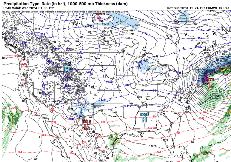
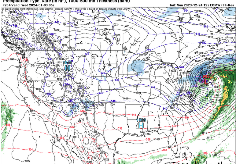
GFS still trying for the 30th
-
That’s an exotically negative NOA … not sure what the problem with that is.
-
If we could just get rid of this piece of shit we might actually have a chance at a rain --> snow NJ model deepener out of next week.
-
Occasional Thoughts on Climate Change
Typhoon Tip replied to donsutherland1's topic in Climate Change
It's why I am really not completely amazed at this December so far over on this side of the N/Hemisphere. If the scale and degree of the U.S. and N/A mid latitude temperature anomalies were taking place everywhere? That would be huge problem like right now - not in 50 or 100 or whatever years. NOW. I don't really trust CNN for science news reprint efforts. I do trust Phys.org - they do a marvelous job at paraphrasing hard science papers right of the submission acceptances. No doctoring through an interpretation mill - or if one doesn't trust that is the case, they always supply a link/referral to the source so you can read it, thesaurus in tow, for yourself The hemisphere is warming, though. This doesn't let the issue/crisis off the hook. You may have just meant that in rhetoric jest but ... we're not really balancing because it's cold over Eurasia. What we can and probably should be doing, is determining December's temperature average all over the N/Hemisphere (everywhere). It is likely above normal. Therefore, not balancing. -
It better snow when it can or else - ...actually, I suspect the warm bias in the east and especially the NE has in part to do with the fact that like the polar regions ( relatively speaking ...) we have more room to rise than the west coast. Doesn't explain the Dakotas very well but that's why I say 'in part' ... Think of it as 'trough cold' is less. Florida and south TX warming is interesting too -
-
Jesus ...where the hell was I. Were these like one-and-done winters? I don't honesty recall those storms - maybe they just were unremarkable where I am.
-
Mm... suspect the patience for hearing any of this is growing thinner with each passing week of having to wait but, that's a pretty cold signal - relative to latitude-based climatology, wise asses .. Formulating into a higher degree of meridian flow in the hemisphere look through the first week of January - on all three ensemble means. ( I'm only bothering to mention it because in this malaise of 'been there done that' hand throwing, I suspect a fairly high probability that people have stopped looking lol ) But, the above is showing up now in the numerical telecon projections, with an EPO mode flipping into negative after Dec 30 - it is likely the meridian flow type is now invading the EPO region enough that the EO functions are being numerically forced ( that oughta ache-up some heads nicely haha) I've been monitoring it and lower EPO index has been increasingly so (2nd derivative). Not only that, the distant GEF and GEPs West Pacific Oscillation projections have that index neutralizing, with most of the spread on the low side. What is interesting about both the EPO and WPO, these so-called "control runs" ( I assume by that they mean, 'call Kevin and ask him what he wants and then the initialize the models to force a sexier solution') are all below the trend line of these index forecast out in time. So ...whatever that's good for. I think the WPO is important as time relentlessly delivers us deeper into the next month (whether we want to or not...). -WPO sets the table for more MJO phase spaces that actually constructively interfere with the ENSO base. Sweet! For winter storm enthusiasts... you really want the AB Pacific circulation variant of the warm ENSO forcing. In simple terms ... that would be a meridian conveyor of colder air toward N/A mid latitudes, while the southern stream is moisture jacked. I know people want dates.. but I'm talking "deeper into January" because that's all that can be defined for now. We're not talking about a winter storm here. We're surmising pattern scaffolding.
-
heh ...yet it's the only model demoing any consistency with that whole fracas
-
That oughta set up the mood around here good and proper ... D.C. with a foot of snow in the first week of January
-
I get the sentiment but ... in this case, I think it's a little out of line. Sub 540 dm hydrostats with NW flow preceding and DPs between 12 and 19 the previous afternoon is a legit deep winter air mass. It's just not bone chilling cold or whatever. But it is real and deep and cold.
-
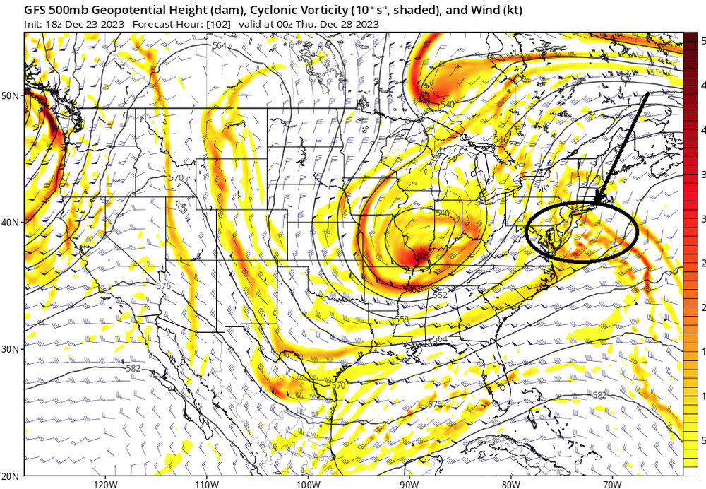
This is a different look compared to prior spreads... The 2 meter 0C isotherm splits the area in half during this means/interval below, too. That's also cooling the column while both surface and aloft collascing on a climate position. Also take not of the 500 mb height changes? It's a situation still in flux to me. The erstwhile +d(PNA) appears to be exerting on the continental super structure in having more weight over the western ridge aspect. This actually helps colder solutions for a couple of reasons -
-
Hmm interesting changes in the GGEM and GFS (oper.) for the 29th/30th It ain't over folks. The debate on whether that interval can turn colder isn't settled yet.