Typhoon Tip
-
Posts
43,368 -
Joined
-
Last visited
Content Type
Profiles
Blogs
Forums
American Weather
Media Demo
Store
Gallery
Everything posted by Typhoon Tip
-
May 2024 Discussion - Welcome to Severe Season!!!!
Typhoon Tip replied to weatherwiz's topic in New England
This is a nerdly interesting... The ensemble spatial-synoptic evolutions do not look very representative of the numerical teleconnectors. That's a little unusual. Neutralizing NAO and a negative PNA should be laying out a warmer canvas over the mid latitude continent. Yet the means synoptics try to prevent summer from ever getting here. The operational version are even worse. The GFS is trying desperately to snow for PF on D10 ... if fails, but it's just seething in want of doing it. jesus christ. April is supposedly the warmest month ever in the world or whatever ... yet again, in an endless series of always warmer than the one before. Just sayn' -
May 2024 Discussion - Welcome to Severe Season!!!!
Typhoon Tip replied to weatherwiz's topic in New England
back building narrow cloud axis should make today's max temp interestingly targeted -
https://www.cnn.com/2024/05/02/us/video/pfas-forever-chemicals-farmland-food-biosolids-digvid ... there are other things that'll kill you because of human ingenuity. The more time that goes by, decades and counting, the more so it appears there is no way off this road. We've sold our futures to innovation and ingenuity, generations ago. Separate discussion but ... human innovation may very well turn out to be the most destructive force this planet has ever known - the verdict is still out. We are going to have to emerge equally as impressive measures and method to ameliorate. The reason why, these various systems appear to be set upon a momentum that is no longer capable of self-correction, a predicament that seems more and more so to require that same capacity to fix. "Silent thresholds." Somewhat analogous to the event horizon of a black hole: the observer doesn't necessarily notice or sense anything unusual when crossing that boundary - only that they can never return to the previous paradigm. The momentum carrying us into a CC realm cannot be countermanded merely by cutting C02 at this point - we've slipped through the proverbial horizon. PFAS and BPAs etc...etc... these so-called "forever chemicals" ( great idea, huh ), the 'momentum' of the damage they cause, the question should naturally arise, will that last forever, too? -this is simple logic.
-
May 2024 Discussion - Welcome to Severe Season!!!!
Typhoon Tip replied to weatherwiz's topic in New England
For warm/spring weather enthusiasts this next 2 week is a direct attack on you personally ... It's giving you days like today, ephemeral and unsustained ..., deliberately so that it can bring you 44 F light rain all day on Sunday at a spiritually maximized torture. A routine the operational models appear to attempt to repeat several times right out to mid May. -
May 2024 Discussion - Welcome to Severe Season!!!!
Typhoon Tip replied to weatherwiz's topic in New England
frustration/kidding of course... -
May 2024 Discussion - Welcome to Severe Season!!!!
Typhoon Tip replied to weatherwiz's topic in New England
nope... apparently, this strata is not physically reactive to any kind of electromagnetic power of the sun - https://weather.cod.edu/satrad/?parms=subregional-New_England-02-24-1-100-1&checked=map&colorbar=undefined -
May 2024 Discussion - Welcome to Severe Season!!!!
Typhoon Tip replied to weatherwiz's topic in New England
Seems the sensitivity is almost entirely NAO causal. I'm noticing that same general improvement after this weekend in the panache of the guidance out in time ( variable depending on which.. but by and large). Meanwhile, all ens sourced teleconnection coverage shows an abrupt neutralization of NAO from ~ -1.5 SD to nominal by early week. The mid and extended range NAO is 0 SD flat-lined from ~ the 5th out into oblivion, after that point in time. Those two facets seem likely connected. During this and recency with -NAO we've kept seeing trough shrapnel and all other perturbations diving SE when nearing 90W/50N ... blunting back any continental westerly flow types from getting in here - that's the -NAO having established as a primary forcing mechanism on the current era synoptics. In short, we need to get rid of that f'ing menace. I also want to add, this is consistent with the last 5 years of spring NAOs. 4 out of the last 5 years have seen a -NAO between mid April and mid Mays. And these were not merely intraweekly excursions in the index values. These were definitive R. Wave structures that pulsed in amplitude in the negative phase states, spanning 2 weeks or more. Those months that were positive outliers, actually still had negative phase states that encourage at least transient negative anomalies. Probably why those positive average mo's were limited to a +.5 SD paltry range. These negative NAO excursive springs have(are) taken(ing) place regardless of leading ENSOs, too - just thought we'd clear that up now - which argues that there is a separate manifold of forcing that is causing this transition season cold regression to take place. We probably don't have to labor the fact that -NAO are going to be more problematic to temperature distribution in NE and SE Canada than anywhere else on the continent. Particularly when the -NAO is biased over the western limb of the domain - which they have been just going by both memory and a-priori. Well, looking at the two recent days of 80 F in N PA while we sniff low tide cool air smells in Worcester certainly fits the bill. -
Report: Another Year of Record Heat for the Oceans
Typhoon Tip replied to donsutherland1's topic in Climate Change
This is an interesting article over at Phys.org, https://phys.org/news/2024-04-atmospheric-teleconnections-sustain-blobs-northeast.html This is statement is concerning, "...The fundamental problem is that warmer waters hold less carbon dioxide and offer fewer nutrients for the plants and animals that exist there..." On the other hand, science has shown that the oceans in general "absorb 25 percent of carbon dioxide emissions and captures 90 percent of the excess heat generated by these emissions" - https://www.un.org/en/climatechange/science/climate-issues/ocean. ( I've read this in countless other direct sources of peer reviewed/publications) If (then) warmer oceans hold less carbon dioxide, and we are seeing the oceans warming at a non-linear increase ( the future will test whether that is temporary...), that should infer a -d(absorption) capacity. See ? this is how 'run-away' green-house warming begins. -
Occasional Thoughts on Climate Change
Typhoon Tip replied to donsutherland1's topic in Climate Change
Just in an intuitive sort of consideration ... it's almost humorous. It took this planet a half a billion years and more to create and stow all of these highly volatile 'fossil fuels.' Humanity, with their genius innovation, arrive on the scene "needing" to liberate that volatility ... back into a reactive environment, just since the IR. 500,000,000 years going in ... Since the Industrial Revolution, ~ 0.000045% of the same amount of time going the other way. How can that happen without consequence. -
May 2024 Discussion - Welcome to Severe Season!!!!
Typhoon Tip replied to weatherwiz's topic in New England
At a minimum requirement for recovering temp today the mid and high level cloud levels need to pass off. Check ... But as that miasma slips off the area, it is exposing some of the densest low level strata there can be without actually being underwater. man The sun is very intense at this time of year though. -
Hey... modestly entertaining to me. I consider you lucky all things considered. to each his own I suppose... Trying to brighten here. Temp surged from 51 to 58 when that happened. It really wants to be quite a bit milder than it is today, but clouds ftl
-
Also, the training convection .. VT/NH central zones is related to this BD. It's circumstance is causing the larger synoptic environmental warm pattern ( to wit, there's a ridge over eastern N/A mid latitudes that's really not receding very much ) to flow up and over the cool air mass E of western NE terrain... It then hits it's buoyancy sigma and boom. Is there any thunder with with that?
-
May 2024 Discussion - Welcome to Severe Season!!!!
Typhoon Tip replied to weatherwiz's topic in New England
It's probably for the benefit of all mankind, either way. But ... I will not post in this thread, henceforth, until the phrase "severe weather season" is erased from the title - -
It's 63 in KHFD at the moment... up 6 since 7 am. It's 51 KBED, up 1 since 7 am. Both locations are reporting full cloud coverage. Both sites also reporting N or NE, albeit very light, wind flow. High res vis imagery displays the entire pan-regional scale in inundated by canonical BD jamming, https://weather.cod.edu/satrad/?parms=subregional-New_England-02-24-1-100-1&checked=map&colorbar=undefined The deeper layer thermal profile would support temperatures similar to yesterday if crucial insolation were allowed to heat the lower levels. Scott and I noted this yesterday, the lighter wind field and so forth ...this is really going to come down to how much sun gets through. Obviously this more likely in CT than E. MA. We are just a week away from entrance into solar maximum, lasting ~ the next 91 days henceforth. It's not like some magical boundary where all the sudden it matters... Being this close already we're getting roasting sun - when it is allowed through. We've seen it be in the high 40s on July 4.
-
based on what the models had been suggesting, I'd take a 59 with partly sunny and run with it!
-
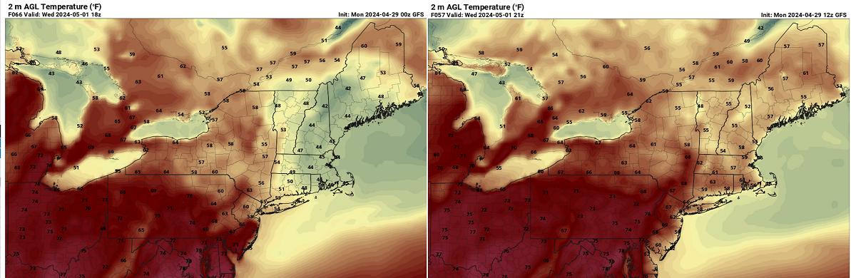
Actually the GFS was hugely improved ... but again, not sure we should trust this. Baby steps.... I think a lot of the sensible appeal will come down to how much cloud we have to contend with. Notice N Maine is warminger than Brian, regardless of these versions below. Probably owing to clouds and rains Also, the wind fields appear pretty COL like much of the time, with weak gradients in every direction, that may limit the ocean penetration to just Scott ( haha,j/k)

-
Not out of the woods yet though. Models are clearly having some issues with things.
-
Hey Kevin, the 12z Euro backed off on Wednesday a little. Has you near 70 instead of 55... Just trying to be fair ...and also, poke the hornets nest. lol
-
I fear this summer may theta-e stagnate like last year and be an 85/75er ... It'd be 'oh my god' cc's coming to get us above normal and all, yet it never touches 90. Which would be okay ... but 88/76, not sure I dig that
-
It's gonna fill in up here in an hour. That stuff over VT is advecting SE pretty fast. We'll cap around 75 here and than slowly deteriorate under mostly cloudy here this afternoon. Which is fine all things considered. Like I was saying to Scott, this isn't coming through like a low level bulldozer of cold behind it like BDs of tragic lore. This will turn ugly when the wind turns east tonight and we start packing ocean smellin' low tide air and strata clear to the Berkshires.
-
It's kind of interesting ( ...sort of haha) but this isn't coming through as a BD technically. After days of bitching and and whining about it, no less. Seriously, the fronts a N-door oriented boundary. It's settling S, too - not blasting through. It's really more of a BD as it turns SW for NJ later tomorrow or whenever. But because of this aspect our winds here up along RT poopy are so far more variable N. CAA depth isn't there. In fact, at 850 mb, the thermal layout only barely dents as all this shallow misery cuts underneath this week...etc. It probably sucks for you down there given your proximity to the ocean - obviously - compared to metro west boston and out beyond 495 etc, early on. It also doesn't hurt that the band of clouds associated with the front has sliding S and we're getting a lot of sun. 73
-
Actually though ... being more practical for a moment: I can too clearly recall those old days of the 1990s and only having a vaguer pre-cognizant awareness that these obtrusive corrections were coming. The GFS may be right with that 44 F at BED at 18z on Wednesday - I've seen it happen in the past at this time of year. So assuming it does, I can coherently remember that was seldom seen ahead of time by the modeling 20 years ago. The resolution and improvements are outstanding - as much as we complain about the general winters, and unfairly ( probably ) scapegoat the models for it.
-
Fwiw, it's 70 here already. 10 after 10 ...prooooobably doesn't apply today? heh. just a guess. Otherwise, we'd probably be 80 .. 82 degrees this afternoon. This is what the GFS was apparently designed for - to maximize the penetration misery of the 'back door' hahaha
-
The funny thing is ... of this list of malcontents you gave, the patterns actually did change from time to time. And were called ahead, successfully. That did not matter - that's the rub. Just sayn'
-
Yeah we all have our individual preferences ... Some are more honest and forthcoming about what those are, whether other people care to hear about it or not. LOL. Like me, I write about hating and despising all forms of these low level backward/negative temperature flows of BD circumstances, and feel pretty strongly that anyone who privately covets them and the opportunity to "lavish" in 43 at BED while it is 78 at EWR ... is probably internally dysfunctional on on some lever or another. To each is his/her own. I suspect the majority are in their right mind, though, and hate and despise BN temperatures at this time of year, too ... cuz', what I think should be is of most importance LOL. Bear in mind ... it's probably slate gray skies with hints of drizzle at times in those 40s and 50s while you are deciding if this region of the country is still worth it. It's not worth it to me any longer. I've outgrown the dystopian fantasy of big snows and dramatic winter storms in general. I didn't feel nearly as "lovelorn" by the bad ( on balance ... ) recent 8 years of winters. In fact, by the ends of September, as the days began to noticeably shorten, I began feel, 'oh man, really?' at the prospect of it. My other Met friends in their 40s and 50s have been expressing similar emotions. 'not sure I care anymore.' Life outside the child, perhaps. I think it's just a maturing thing. Once the mind inexorably extends beyond the framework of what one's own experiences are, opens up a lot more to be fascinated about ... Once that is triggered, stales the old. I mean we've got too many extraordinary unprecedented aspects that are coming over the proverbial horizon due to you-know-what, and the experience of "the global phenomenon" It has become matter of insularity, really, to remain.