

Typhoon Tip
-
Posts
43,363 -
Joined
-
Last visited
Content Type
Profiles
Blogs
Forums
American Weather
Media Demo
Store
Gallery
Everything posted by Typhoon Tip
-
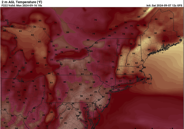
September vibes - Last 90s for some, 1st frost for others
Typhoon Tip replied to tamarack's topic in New England
hm impressive warm signaling continues ...extent of which tbd but 12z gfs over 594 dm ridge node parked over alb isn't very normal post 9/10s also have to wade thru model amplitude bias in the mid/ext ranges but the consistency in that direction has a lot of aggregated model runs at this point, too -
September vibes - Last 90s for some, 1st frost for others
Typhoon Tip replied to tamarack's topic in New England
okay just the 12z op euro and 18z gfs continuing trends ...that's approaching a historic signal out there. -
garbage solution
-
September vibes - Last 90s for some, 1st frost for others
Typhoon Tip replied to tamarack's topic in New England
-
September vibes - Last 90s for some, 1st frost for others
Typhoon Tip replied to tamarack's topic in New England
substantial bd on the euro late next weekend - been more and less on that model for a few cycles. agreed, warm pattern but we suffer for our circumstantial region and bd's preferential to 'warmer patterns' only difference between apr and sep is they don't have as much d(t) bite in the latter. sill ... 2 m's collapse from mid and upper 80s to low 60s course ... 7 days away and all - -
it's times like these that i wonder if the model's get exposed and they really do goose them toward climate. because the hemispheric scaled limitations that have ( and apparently continue to do so ...) been smothering activity don't appear to be alleviating in the latter mids ... yet they keep tryin and tryin to spin up mdr cumulus. the western gulf has legs if the fire hose shear were to slacken off.
-
September vibes - Last 90s for some, 1st frost for others
Typhoon Tip replied to tamarack's topic in New England
00z was better at 500 mb for heat signaling... 12z is about 5 dm shallower with dome node and also quicker to conjure up bullshit ( what's new with the gfs's magical grinding mechanics with that... ) to erode it down. it may not matter yeah yeah if the 800 mb and llv synoptics winds are remain favorable - just speaking to the standard metric. -
September vibes - Last 90s for some, 1st frost for others
Typhoon Tip replied to tamarack's topic in New England
might be the warmest 850 look leading this pattern change yet -
it starts in the asia dispersion/wpo
-
some are already aware but useful recap/nested links either way... https://phys.org/news/2024-09-earth-hottest-summer.html
-
I’m suspicious of the melt season lasting 10 or so days late.
-
what's perhaps most daunting of all about that svalbard location is that it's not like a freak low pulled a warm plume ... we're talkin' about a whole month average.
-
i'll give the guy credit. that's a humorous delivery there -
-
September vibes - Last 90s for some, 1st frost for others
Typhoon Tip replied to tamarack's topic in New England
probably a lot of 80s with unusual warm nights d6 to 11 solar's nearing the equinox. the lower troposphere is only marginal for 90 . if the modeling starts warming further then maybe we score a late 9 0 -
https://phys.org/news/2024-09-south-korea-highest-average-summer.html
-
It’s interesting that neither candidate’s addressed gun control - seems that of all travails society faces the imminent peril is clearly one devouring itself … seems worthy of at least a mention.
-
I mean what … it’s only been a couple o months since that last mass shooting
-
you know ... i admit to not taking the 00z nam very seriously. heh, why should i - but seeing it persist with the 06 and now 12, re a rapid book-end spin up tracking toward cape code, and the euro being more than less on board, i would think at least marine interests around the horn should be made aware. i'm sure that's happening - so maybe more for us lol it'll probably miss. nam may be both right about existing and wrong about where. but the point is, it's short term/now cast
-
oh, duh - the embedded links bluewave provided there seems to suggest that. so yeah
-
you know i have a completely ot thought on that. the warming med has been prevalent. i've been wondering if at some point the ohc being an abutter to the aridity of the n africa might get interesting. ... at what point does (or could) rising saharan heat start drafting in very high latency/wv content - similar to other monsoon circulation modes around the world. like i said, ot. heh
-
yeah i could nod to this approach we exist in ( and because of ..) the kind of complexity that is not just linear, but is interactions among products as well. these latter interactions in turn cause emergence that are difficult ( to put it lightly ) to predetermine, because when attempting to do so, they may not even exist if the linear products are not precise predicted. with all that calamity ... there's no way, zero possibility, that a systemic behavior is a result of a single input. it comes down to amounts of contribution - with a dose of spatial relativity.
-
September vibes - Last 90s for some, 1st frost for others
Typhoon Tip replied to tamarack's topic in New England
25 to 30 deg deltas by 10:45 am is pretty fantastic. 47, now 75 kfit 50 --> 75 -
oh shit yes. of course. not intending condescension there ( ha) no but just as a base physical consequence to more warm air, it evaporates more water. that means the ambient atmosphere holds more water mass - such that all events in that same ambient medium will avail. that very basic concept is why rain rates have been increasing around the world ... in close correlation with cc ...etc. no question remains re that connection. based upon that facet, increasing ( non dispersive ) ohc, and then inducing a mechanism to release it - that's sort of what i was 'hinting' at with that 'restoring going the other way' thing a while ago etc - that sets up regions in storm frequency to additional prolific results. the in situ storm gradients become excessive - the baroclinic physical result is rain ( or snow or whatever ). positive feedback ==> evening news
-
i know in all seriousness tho i was more actively posting related material about jesus ... 5 years ago. but it was new then, necessary to get word out. i've since supplied links to papers and so forth. side's hc isn't everything. it's definitely a part of the roni "integral" - whether the authors of that science are aware or not. but the regions outside hc are also guilty in the offsetting too. hc isn't as paramount to the discussion as is considering the entire planet.


