Typhoon Tip
-
Posts
43,363 -
Joined
-
Last visited
Content Type
Profiles
Blogs
Forums
American Weather
Media Demo
Store
Gallery
Everything posted by Typhoon Tip
-
December 2024 - Best look to an early December pattern in many a year!
Typhoon Tip replied to FXWX's topic in New England
yeah, i wasn't going to delve very deeply into topic considering the range - keep it orbital... i will add, already by 270 hours the changes between hawaii and the west coast are underway with aggressive multi day trough presentation there. in the spatial correlation, that furnishes down stream +pnap over n/a. the look from 270 -360 hours (324 blw), albeit too extended to be 'strung out' over it ( lol ), this does not appear to balance the former signal enough imo. it should be more meridian in structure than we are seeing here - ... it's likely there are some poorly resolved members distracting the mass conservation. the 'correction vector' is pointed toward an amplitude, so if neg domain situates out there's likely more NW flow through central canada.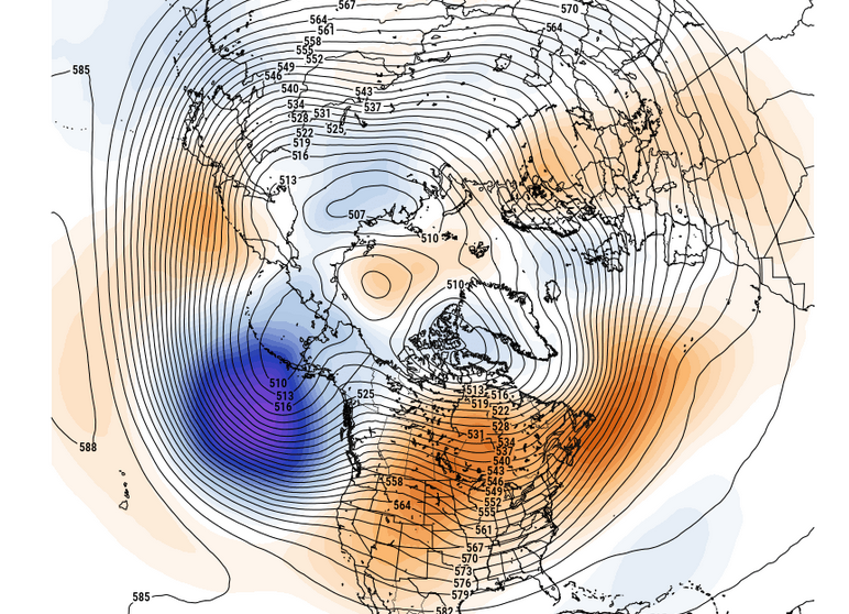
-
December 2024 - Best look to an early December pattern in many a year!
Typhoon Tip replied to FXWX's topic in New England
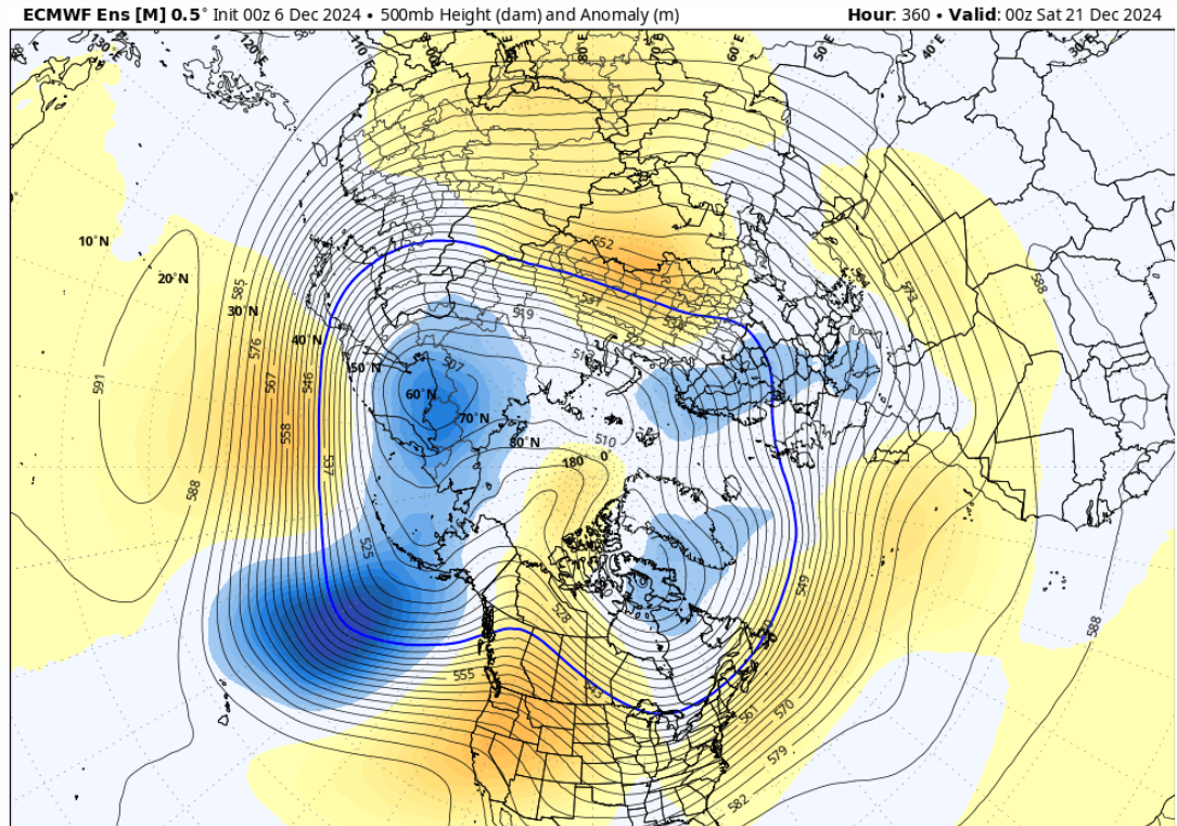
here's the geffies from the 06z ... this signal is pretty damn bright considering the distance out there in time. and, considering the distance ... there's likely a few members contributing to this mean with more wholesale/considerably deeper continental responding meridian layout. haha, lot of 'longitudinal' words to say that the flow is probably less flat between seattle and boston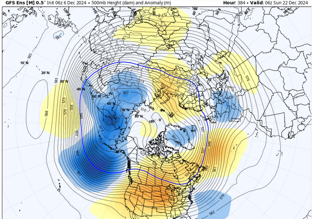
-
December 2024 - Best look to an early December pattern in many a year!
Typhoon Tip replied to FXWX's topic in New England
this is waaaay out at the temporal edge of the run but this has been increasing a bit in the fantasy product suite. for how little it is worth. this is a deep and massive +pna trough that is in the process of arriving/emerging n-ne of hawaii. that downstream structure across the n/a continent would be forced into a ridging along 110 or so w within mere days.
-
December 2024 - Best look to an early December pattern in many a year!
Typhoon Tip replied to FXWX's topic in New England
oh i've used the 'carpet surfing' metaphor myself in the past. lol -
December 2024 - Best look to an early December pattern in many a year!
Typhoon Tip replied to FXWX's topic in New England
bit of an unmanned fire hose pattern in the operational version tenor, as we head through mid month. however, the telecon spread favors warmer than normal. it could go either way. the operational 06z gfs has an impressive mid/ua ridge for stint out there mid month, that the 00z used random pacific wave traffic to effect a suppression. the ridge is there though, regardless. but this oscillating has been notable over recent guidance cycles wrt mid month - likely owing in part to the fact that it is 'mid month' and here it is only the 6th. but since the pattern foot isn't really committing to a more coherent - or + pnap ...the whip end of the hose is flopping around in model runs a bit more than usual. the euro's been less varied. the ggem is ... the ggem. one thing i will add here, even if a ridge were to become more likely ... it's not clear that we won't have it be top heavy with high pressure n. that's typically a warm pattern with a cold uneventful, zip remarkable surface. oooh sign us up! ha, but if the lower trop can be wedge-cool enough... maybe supplying tainted drug doses that are better than rocking back and forth in a straight jacket with blood shot eyes the wpo is neutral positive. as that implies, not hugely positive but it is rising and passing into the plus side of the 0 SD. given some lag, the epo will tend to catch up and demo the transmittance of the former/upstream forcing - however, all three ensemble means actually have a neutral-negative epo as we age toward xmas. it's interesting. meanwhile, all ens sources have a -pna at least for 3 to 5 days, through the 20th, and the (recent) beginnings of a positive mode change after that time - obviously that's getting far enough out there to where it's mere conjecture only. -
December 2024 - Best look to an early December pattern in many a year!
Typhoon Tip replied to FXWX's topic in New England
has there been enough snow to really be a 'melt' concern? -
December 2024 - Best look to an early December pattern in many a year!
Typhoon Tip replied to FXWX's topic in New England
oh ... you're new here. yeah, this social media outlet is actually a support group for those that have a bizarrely particular ocd/special interest requirement, where their functionality is strung along by the vagaries of these things called " forecast models" it's almost like the models are not forecasting the weather... they're forecasting the atmospheres of domestic harmony in the households of these contributors - -
https://phys.org/news/2024-12-rapid-surge-global-due-planetary.html "..If a large part of the decline in albedo is indeed due to feedbacks between global warming and low clouds, as some climate models indicate, we should expect rather intense warming in the future," he stresses...." the interview doesn't go into 'why-for' lowering of low-level cloud production over the tropical Atlantic. but, I wonder ... hm. I've been reading about the increased moisture content penetrating deeper and deeper into the Saharan regions of Africa - attribution suggesting changes in the monsoonal footprint due to cc ..etc. there has even been observed 'greening,' and even episodes of transient pooling/lake genesis from heavier rains in regions. so what i'm wondering is whether aerosol soaking and greening might cause reduction of Saharan dust/eject off of Africa, to go along with the circulation changes associated with monsoonal variation ... the combination of these possible factors may lower the condensation nuclei populations, more at 'invisibly' less than normal, acting as a suppressor of lower tropospheric clouds --> lowering Albedo. one of the nerd things i like to do during the hurricane season is to monitor sal (saharan air layer) sat channels. there's still sal present, per bulk resolution ... however, i wonder if a more discrete mass quantification analysis, might expose that the actual sal density has been decreasing during these recent years of increasing albedo. the purpose of this idea is to target a cause of lowering cloud production. cloud suppression could also result from expanding hadley cell ( attribution..). internal within the hc domain, vertical motion fields, on balance, will be dvm (downward vertical motion). as the amorphous boundary where the hc terminates into the westerlies has been expanding n ( and s, s of the quator), there may be increasing episodes of dvm - . there could be multiple reasons for cloud suppression.
-
December 2024 - Best look to an early December pattern in many a year!
Typhoon Tip replied to FXWX's topic in New England
oh i was being kinda of glib - but yeah..it's more where i am frankly. haha. altho q, was boston's above normal in 20/21 from one or two storm type of deal? we've been getting a lot of season-in-one or two storm type years too, which i think shouldn't be used in any affectation based discussion because it's not fair. waahh i can tell you that the 'method' in which these bn years have taken place is very different comparing the 1980s to this last 9 years. that's part of the it - -
December 2024 - Best look to an early December pattern in many a year!
Typhoon Tip replied to FXWX's topic in New England
well .. to be empathetic to the solemn singers, it's been since 2015 ... mmm 9 years is for all intents and purposes a decade, that much of coastal mass has seen normal snow. so saying "just had" ...that's a little gaslighty hahaha. seriously though, it's getting on in age at this point. thing is, we may have slipped over a climate threshold where these 9 years worth of sore butting becomes more normal. i know that's probably going to earn me 0 love hearts, no 100 %'s ... no thankyous and a pile of shit or two, but this is unfortunately our non-zero possible reality at this point. that said, this winter will probably go on to conquer all evil ... just to enable. but the price in selling to that devil might be a new fresh hell of 12 years again over before we pull the cosmic d out of our cc bums ... a time in which the polar ice free waters for the first time. -
my dream is to evolve technology to the point where there is no energy market. but ... since human kind cannot seem to incentivize doing anything without the potential for maximizing economic gain, that will probably continue to bury such advancements - not dissimilar to how/why big oil has conditioned all ir cultures of the world into believing oil is the only way... and has been in place so long that the fallacy is both institutional but also so multi generationally sewn into perceptions that people will blindly defend oil like a throngs of people drinking 'the cool-aide' without even knowing any reason to suspect it... the system propagandizes itself in that sense and the work is done.
-
December 2024 - Best look to an early December pattern in many a year!
Typhoon Tip replied to FXWX's topic in New England
that's because the circulation around the beast was paralleling the geographic striations... if said circulation was more nw or ne, than the shadowing can occur. -
December 2024 - Best look to an early December pattern in many a year!
Typhoon Tip replied to FXWX's topic in New England
ana -form scenarios can happen ...obviously the models are not depicting events that are physically impossible, otherwise ...what are they there for? aside from dopamine dripping the ocd crowd into their psychoabble hard-ons, they are supposed to actually facsimile the atmospheric state, out in time, based upon the rules of nature that govern the atmospheric state ...and so on. however, to a high ish degree of confidence, one can go ahead and assume that reality will be less prolific in ground observation compared to quantities modeled. models are going to be efficient at cloud deposition. but, they will not be very good at the "evaporating integral" between what leaves cloud and makes it all the way down to the ground. how much of the falling moisture content gets eaten by the backside/ana envelope's on-going dry caa, offsetting and so on. there may be a multiple reasons for over assessing how much makes to earth ... topographic resolution, data sparseness from dry air sourcing missed in grid initialization... etc etc. *however, one aspect about ana circumstances out in time, they are there because the model assess a s mid lev flow component, lagging back behind the frontal position, that is riding back over. the front clears a longitude and this immediately instantiates an overrunning. this new overrunning, and over circumstance, is a petri dish for cyclogenesis. in effect, you could say the given construct is one that needs to be watched, because future guidance might take that the next step and start buckling the boundary, with actual warm trying to move the front back west over top a zygote low pressure - we've already seen this in recent runs with that period of time out there. 18z gfs yesterdy for example, that run was an ana that went too far and an actual low formed on the trailing front - or to a reasonable analog to that... -
December 2024 - Best look to an early December pattern in many a year!
Typhoon Tip replied to FXWX's topic in New England
actually looks like a warm front to me ...that early sunday morning whisk through thing. mostly cne up for any expression of it, and by 18z ... 550+ dm ... thickness' west and south zones and 546 with 'polar barotropic' air mass rapidly ne. the gfs has it too, but it then lifts a theta e conveyor for early next week, which it uses to 52 f rain for two straight days or something but it's likely overdone like everything ever modeled in that range+ seems to be these days.. anyway, no one asked but it looks to me like a warm burst could materialize circa 15th -20th. not a certainty but ... i would suggest folks consider that despite the recent cool snap and today's treat, don't be lulled into thinking it's 1995 again. we still are very much in a larger/longer/planetary circumstance of 'anything that can go warm usually does and exceeds expectation' sort of reality. if -epo does bias west, together with that underpinning -pna during tht time range we will be 70 deg. the key is the ne pac and how it might transmit forcing down stream. nuanced -
ncar's rad history doesn't make it abundantly clear why-for the paltry exclusion here. though there was a modest lull around 3 or 4 am, it was filled back in with green rad returns by dawn. i think perhaps the very marginal nature of this doomed the light fall rate locations. my friend in auburn was probably falling faster than melt rates, so was able to accumulate, where we were falling slower. distribution ends up being either 1 inch or 4 with less in between.
-
similar here... est .5" of glop snow in grass and sliding down car windows. just wet roads. my buddy down in auburn ma with 5" ( s of orh by a little ). this 'event' needed something like a quantum computing core to better predictively assess where. lol ...
-
Mad squall in Southwest lower Michigan right now… My sister says there’s crazy lightning and thunder with white out wind snow
-
December 2024 - Best look to an early December pattern in many a year!
Typhoon Tip replied to FXWX's topic in New England
yeah that's an interesting look, that 18z long duration mixer. lasting some 30 hours. the wpo is neutralizing ... finally. it had been correcting neg as it was emerging but that has ceased. however, the epo is trending down. i don't believe these two make for a very stable hemisphere and something is likely correct. but how. in the mean time, the pna slips neg. the weighting of the 'tippy' flow tendency with vestigial -epo vs these other warming signals is unclear, but i'd be prepared for more model noise than usual ... least through the 10th -
December 2024 - Best look to an early December pattern in many a year!
Typhoon Tip replied to FXWX's topic in New England
probably false/machinery but there was a tor warn tripped in a squall passage associated with the arctic front out in se minnesota
-
was he in the tournament back a month ago ? my crew and i were in that
-
not associated to the "clipper" ...but there is a weak windex signal skirting through. snow squall looking features on rad out around eastern ny probably sweep through
-
that's a nice disk golf course there ... we used to regular that one back in the day. my buddy moved to southern orh co and so the last several years we've been hitting buffum and pyramids and maple hill etc.. we keep swearing we'll get back out there for old time sake. i hear they changed the course layout though so who knows. it might suck now too
-
i know...ha, cut and paste one of my gems and send that out to the pta while you're at it
-
oh.. right. no i meant that at a societal/general scope of this field, but may as well be everywhere heh. it's a problem in culture..."eschewing of intellect" in general. it kind of reminds me of "Idiocrasy," when they arrested him for being smart ass because he was smart. hahaha
-
my schadenfruede for tuggin on taint hairs