Kevin Reilly
-
Posts
3,402 -
Joined
-
Last visited
Content Type
Profiles
Blogs
Forums
American Weather
Media Demo
Store
Gallery
Everything posted by Kevin Reilly
-

The return of the elusive Nor'easter. Drought buster or bust?
Kevin Reilly replied to dailylurker's topic in Mid Atlantic
That looks like I winter storm disappointment map; and so it begins! thinking we are getting 1-2 feet of snow and reality is 3-6" maybe? -
E PA/NJ/DE Autumn 2025 Obs/Discussion
Kevin Reilly replied to PhiEaglesfan712's topic in Philadelphia Region
Models are really backing off. Weaker storm almost looks like it splits in 2. -
0z Model runs are trouble up and down the East Coast Outer Banks to North Jersey.
-
E PA/NJ/DE Autumn 2025 Obs/Discussion
Kevin Reilly replied to PhiEaglesfan712's topic in Philadelphia Region
0z Model runs are absolutely trouble for the Jersey and Delaware Beaches all the way to the Outer Banks, get ready! -
I wonder if we get a “Folks”!!!!
-
E PA/NJ/DE Autumn 2025 Obs/Discussion
Kevin Reilly replied to PhiEaglesfan712's topic in Philadelphia Region
0.14” here today. That coastal storm has trouble written all over it for the coast especially the Carolinas to Long Island coastal flooding threat is very high if development and track follows both the Euro and Gfs. Major Coastal Flooding Carolinas to possibly as far north as Long Island. -
E PA/NJ/DE Autumn 2025 Obs/Discussion
Kevin Reilly replied to PhiEaglesfan712's topic in Philadelphia Region
Major Coastal Flooding Carolinas to possibly as far north as Long Island. -
E PA/NJ/DE Autumn 2025 Obs/Discussion
Kevin Reilly replied to PhiEaglesfan712's topic in Philadelphia Region
The 12z runs completely diverged on this idea of a coastal storm next week think we need a few days to iron this one out. I am not sure what the NAO is showing for next week cannot see it on the NWS website (government shutdown maybe?) Looks like the models are trying to trend toward blocking the storm from coming up the coast albeit it only one set of models runs except the 12z gfs so wait and see time. -
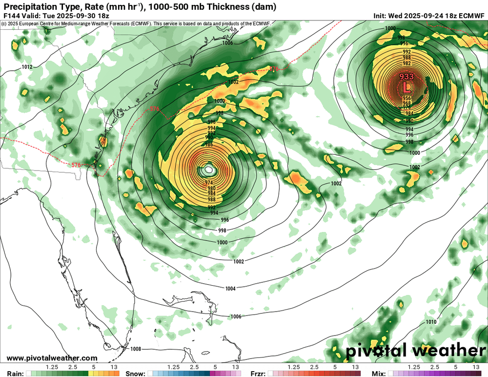
I would bet on it! Extremely warm Pacific Waters Record Breaking actually, Record Breaking Gul of Mexico Water Temps for September and October all time, and a toasty southwestern Atlantic we are pretty screwed east of the Appalachians warm air flooding in all directions.
-
Yea this looks like a depression now or by 11 am as you said. Humberto is pretty far away east from this system. It’s obvious that Humberto turns out to sea gotta wait to see how high pressure builds into the Northeast and Mid Atlantic to put the block in place to initiate movement towards South Carolina, then the stall of Imelda, followed by the bounce off the high to the north and deflection out to sea. Pretty simply put all about exact timing of players build and strength.
-
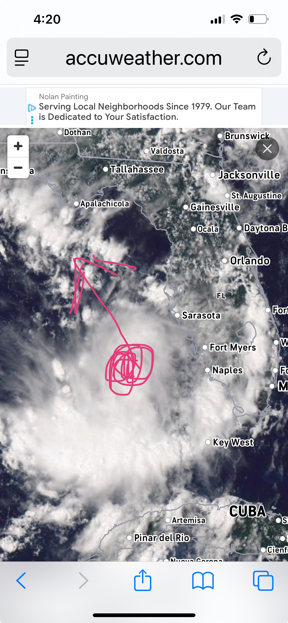
Looks like a center is going to form just north of Cuba on the north Cuban Coast / south of the Bahamas and lift north bound.
-
One thing that is constant on the models all of them is a blocking area of high pressure streaming down from Eastern Canada and off the New England Coast. Both of these systems Humberto and Imelda have no chance of getting north of say Outer Banks points northward. Looks like 18z GFS just changes everything and the westerlies take over along the East Coast and send everything packing up and heading out to sea it is plausible I suppose. I would say at this juncture that the Outer Banks points north are out of the woods from direct impacts, but we could be setting the stage for rough surf and waves from the systems themselves and also the tight pressure gradient from the high up north and the lows down south. Honestly these blocking highs up the coast in the Mid-Atlantic and to SE Canada and New England have been a steady feature going back to July and August. I would not let your guard down Florida to say Cape Fear NC and head any warnings as Neuman eluded to early. Looks like the blocking gates to the east will open to let Imelda to follow Humberto right out to sea as the blocking comes down from the north and the systems bounce east quite plausible.
-
E PA/NJ/DE Autumn 2025 Obs/Discussion
Kevin Reilly replied to PhiEaglesfan712's topic in Philadelphia Region
Just south of Jamica. -
E PA/NJ/DE Autumn 2025 Obs/Discussion
Kevin Reilly replied to PhiEaglesfan712's topic in Philadelphia Region
Humberto yea moves towards Bermuda then out to sea. I am pretty sold on that. However, what is south of Puerto Rico I am not so sure. That would become Tropical Storm Imelda. I would think Imelda is a threat to the United States East Coast South Carolina to New England. Humberto leaves stage right then high pressure builds and traps Imelda forcing Imelda toward the United States East Coast next week. Time to watch, I think. I am always weary of tropical systems developing in September and October down near Puerto Rico Hatti because chances are they are heading up the east coast with troughness around to our west and high pressure to the east. See below I’d say time to monitor.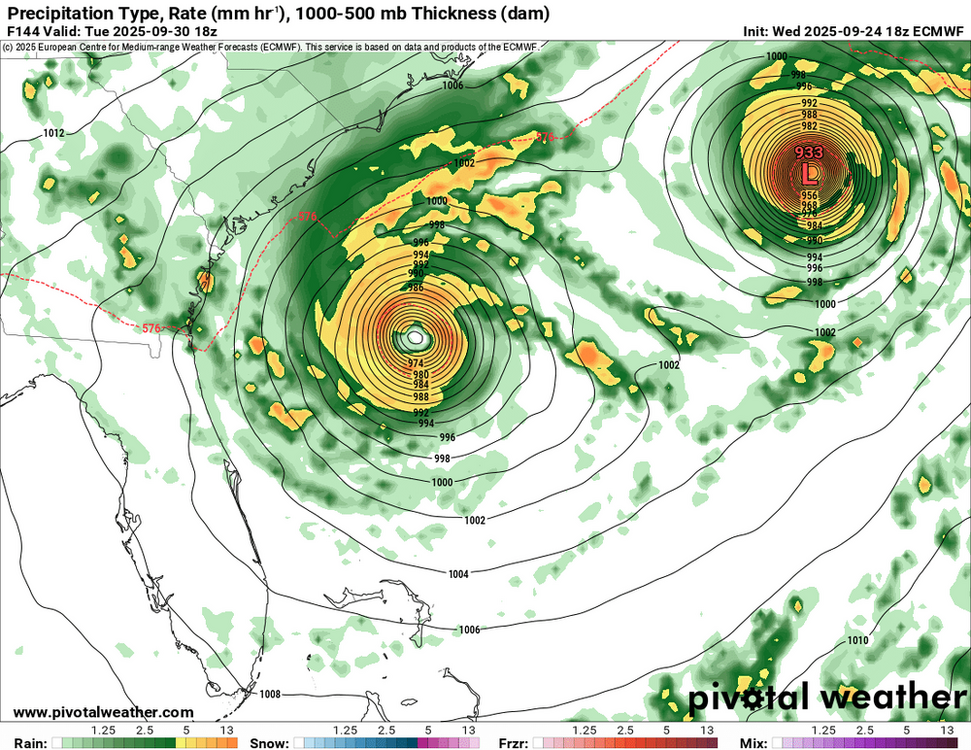
-
E PA/NJ/DE Autumn 2025 Obs/Discussion
Kevin Reilly replied to PhiEaglesfan712's topic in Philadelphia Region
Total rain down here in Media the other day was 0.48" not too bad actually. -
2025 Atlantic Hurricane Season
Kevin Reilly replied to BarryStantonGBP's topic in Tropical Headquarters
Think I heard it was a cold core storm, but honestly the radar representation screams a subtropical or weak tropical storm for sure. Ocean water temps there NE North Carolina to VA Beach probably low to mid 70's. -
E PA/NJ/DE Summer 2025 Obs/Discussion
Kevin Reilly replied to Hurricane Agnes's topic in Philadelphia Region
Here in Media we have 0.45" for the month lol. -
E PA/NJ/DE Summer 2025 Obs/Discussion
Kevin Reilly replied to Hurricane Agnes's topic in Philadelphia Region
What is this rain? zero percent chance of rain today? 66 light to moderate rain here currently. Humidity 85% dew point 59f I am guessing an upper air disturbance is developing overhead in conjunction to near by cold front. You can see the seeds of winter 2025-26 we would be getting mood flakes right now as colder air rushed in. -
E PA/NJ/DE Summer 2025 Obs/Discussion
Kevin Reilly replied to Hurricane Agnes's topic in Philadelphia Region
Today's high 94f after a low of 70f Sunny all day. Rainfall today Total: Trace a few drops at 9:20 pm lightning east. Currently 78f humidity 86% dewpoint 74f -
2025 Atlantic Hurricane Season
Kevin Reilly replied to BarryStantonGBP's topic in Tropical Headquarters
Yea so Erin is kind of the lead running back to scour out the remaining Saharan Dust and dry air opening the door to other features as we move towards the peak of hurricane season. -
2025 Atlantic Hurricane Season
Kevin Reilly replied to BarryStantonGBP's topic in Tropical Headquarters
I guess we should ignore the direct strike at Daytona beach in 11 days August 26th? -
E PA/NJ/DE Summer 2025 Obs/Discussion
Kevin Reilly replied to Hurricane Agnes's topic in Philadelphia Region
Flash Drought!!!! Where's Drought Guy?? I may have cut the back yard for the last time this year. Yea, right we know what's next a Hurricane coming up from the Carolinas! -
2025 Atlantic Hurricane Season
Kevin Reilly replied to BarryStantonGBP's topic in Tropical Headquarters
I would definitely watch this feature. My friend that lives along a canal in Cape Coral just NW of Fort Myers says that the canal is up to the top and water rises of about 2-3 feet are common right now. Looks like weak shear environment or about to be soon and steering currents look like South-southeast to NNW towards the Florida Panhandle. Looks like the upper air low sitting on top of Houston Texas and a push westbound will be the main steering features right about now. Unrelated to this but the blocking up north is very evident. Everything is moving from Halifax Nova Scotia all the way to Chicago all the way north and south. That is quite the blocking signal.
-
SE Area of Interest--10% two day, 20% five day odds
Kevin Reilly replied to WxWatcher007's topic in Tropical Headquarters
What that storm did do is up well the waters pretty good here in Kitty Hawk water temp has gone from 84 to 75 in the past day or so; I am sure this is temporary. -
The flow down here in Kitty Hawk has been NE and east since last Saturday. Temps in the 70's and water temp in the 80's. Currently cloudy patchy fog / drizzle 74f wind NE 20-30 mph.