Kevin Reilly
-
Posts
3,401 -
Joined
-
Last visited
Content Type
Profiles
Blogs
Forums
American Weather
Media Demo
Store
Gallery
Everything posted by Kevin Reilly
-

SE Area of Interest--10% two day, 20% five day odds
Kevin Reilly replied to WxWatcher007's topic in Tropical Headquarters
Ehh even if that develops it will just ease off to the east and east northeast once it gets to the latitude of say Cape Fear NC. -
SE Area of Interest--10% two day, 20% five day odds
Kevin Reilly replied to WxWatcher007's topic in Tropical Headquarters
Sea Surface temps up the east coast are a bit concerning for a tropical system IF atmospheric conditions are right to maintain its energy well northward up the coast. Now with how wet it has been minus the last week in the Mid Atlantic up to NYC and northern New Jersey could be setting up for a few rough weeks from now until say August 25th depending on what both systems do up the East Coast. System #1 Late week into the weekend and early next week System #2 August 15th to 20th sitting out in the western MDR right now. Case in point I am in Kitty Hawk NC right now and ocean water temps have been running 82-85 on the regular since I have been here Saturday. -
Pretty cool here in Kitty Hawk NC 76 dew point 58 with winds screaming in from the NE 20-35 mph double red flag warning no one allowed in the 6-8 foot surf. I’m pretty sure the ocean water temp is like 82 too crazy times.
-
2025 Atlantic Hurricane Season
Kevin Reilly replied to BarryStantonGBP's topic in Tropical Headquarters
So long it doesn't visit me in Kitty Hawk Outer banks I am fine. I will be there August 2nd to August 9th. -
E PA/NJ/DE Summer 2025 Obs/Discussion
Kevin Reilly replied to Hurricane Agnes's topic in Philadelphia Region
I saw a few flying around in the backyard 2 total while I was cutting the grass this on Monday. The hornets typically nest into my small hill along the driveway in mid-July I don't see them yet. -
2025 Atlantic Hurricane Season
Kevin Reilly replied to BarryStantonGBP's topic in Tropical Headquarters
I mean those two maps basically follow normal climatological patters of the Atlantic Ocean over many years from what I can remember really. I see nothing that screams we will not see normal to above normal hurricane activity this season. However, it screams East Coast impacts which was my thinking earlier last week. -
E PA/NJ/DE Summer 2025 Obs/Discussion
Kevin Reilly replied to Hurricane Agnes's topic in Philadelphia Region
Seriously Paul, I am becoming more and more concerned for our area when the tropics visit later in the season due to all these areas picking up 3-8" of rain off and on daily. Water temp down here in Sea Isle had to be close to 80f last two days just walk right on in the water zero getting used to any inkling of cooler waters. I saw an official report of 82f down in Cape May yesterday. I am not exactly sure what it is here in Sea Isle but yesterday last two days I would estimate 78-79f or so. There have been three days of east then southeast winds down here currently winds are pretty light and generally west-southwest at like 3 mph. I can envision tropical systems turning up the east coast this year as the current trough lifts out and retrogrades west or northwest bound you can almost see it coming. -
E PA/NJ/DE Summer 2025 Obs/Discussion
Kevin Reilly replied to Hurricane Agnes's topic in Philadelphia Region
Sounds good Paul! Hopefully I don’t get water into the basement coming off the roof too quickly. I’m down in Sea Isle right on the beach at 69th Street. Looks like ocean water temp is about 77f -
E PA/NJ/DE Summer 2025 Obs/Discussion
Kevin Reilly replied to Hurricane Agnes's topic in Philadelphia Region
I’m here 69th and the beach amazing shots! Almost looks like sunrise.
-
E PA/NJ/DE Summer 2025 Obs/Discussion
Kevin Reilly replied to Hurricane Agnes's topic in Philadelphia Region
Just a few left over drops of rain 72f humidity 98% dewpoint 72f Total Rainfall: 2.90" -
E PA/NJ/DE Summer 2025 Obs/Discussion
Kevin Reilly replied to Hurricane Agnes's topic in Philadelphia Region
Looks like another tornado warning down in Sussex County Delaware Moving NE towards Delaware Bay currently. Thats an impressive line down to our south. Looks like a mesoscale low just south of the Delaware Memorial Bridge moving NE at 20 mph or so. -
E PA/NJ/DE Summer 2025 Obs/Discussion
Kevin Reilly replied to Hurricane Agnes's topic in Philadelphia Region
Light to moderate rain some left over lightning and loud thunder. 69f humidity 97% dew point 69f Total rainfall: 2.52" -
E PA/NJ/DE Summer 2025 Obs/Discussion
Kevin Reilly replied to Hurricane Agnes's topic in Philadelphia Region
Looks like a new area focusing right along the Delaware River down to Delaware Bay. Looks like a mesoscale low just west of Dover Delaware moving NE. -
E PA/NJ/DE Summer 2025 Obs/Discussion
Kevin Reilly replied to Hurricane Agnes's topic in Philadelphia Region
Moderate rain lightning thunder no wind 70f humidity 97% dewpoint 69f Total Rainfall so far: 2.40" all falling since 7:15 pm. -
E PA/NJ/DE Summer 2025 Obs/Discussion
Kevin Reilly replied to Hurricane Agnes's topic in Philadelphia Region
Currently 73f humidity 95% dewpoint 72f Cloudy light rain left over and some lightning streaking across the sky especially south thunder. Total rainfall 0.28" (that is it) -
E PA/NJ/DE Summer 2025 Obs/Discussion
Kevin Reilly replied to Hurricane Agnes's topic in Philadelphia Region
No doubt that happened here! -
E PA/NJ/DE Summer 2025 Obs/Discussion
Kevin Reilly replied to Hurricane Agnes's topic in Philadelphia Region
mesoscale low very impressive and evident. -
E PA/NJ/DE Summer 2025 Obs/Discussion
Kevin Reilly replied to Hurricane Agnes's topic in Philadelphia Region
Still sunny here gathering clouds west and southwest very low rumble of thunder way off in the distance. Sunny 93f feels like 103 humidity 53% -
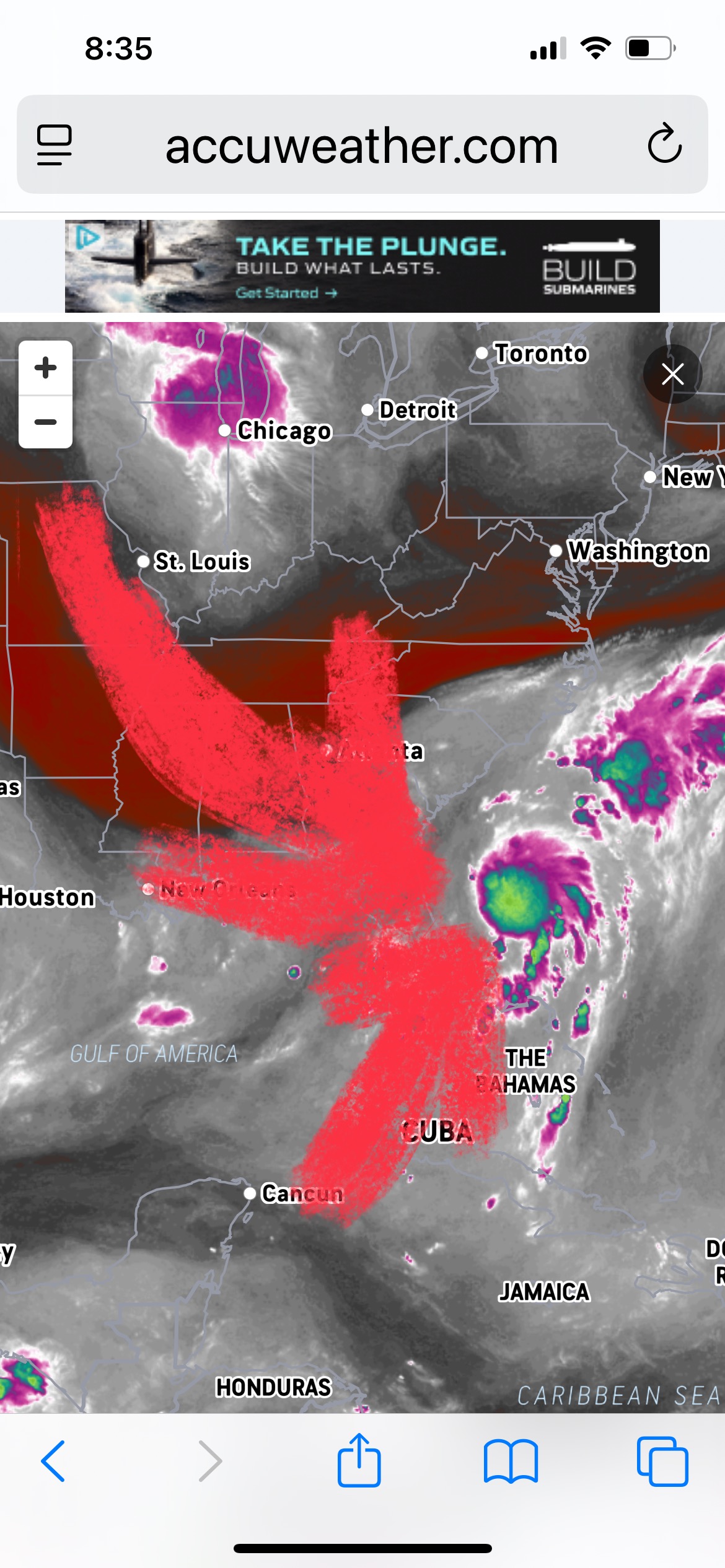
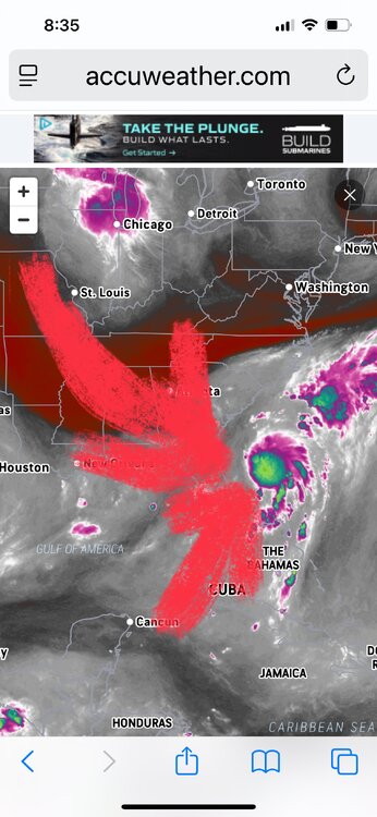
Good outflow aloft. Looks like depression to me or even a 40-45 mph Tropical Storm Chantal. Small Upper level low just southeast of Atlanta Georgia and dry air punching in from the northwest should limit development but also should tug what could become Chantal towards the southeast South and North Carolina coastline before gradually moving back off to the northeast. Another interesting area well to the east of the Bahamas. Things waking up a bit out there.
-
E PA/NJ/DE Summer 2025 Obs/Discussion
Kevin Reilly replied to Hurricane Agnes's topic in Philadelphia Region
Guess drought is done or been done. -
E PA/NJ/DE Summer 2025 Obs/Discussion
Kevin Reilly replied to Hurricane Agnes's topic in Philadelphia Region
Hopefully things will move progressively which could become the case. I will be in Kitty Hawk first week of August good times in the Banks, but yea better weather is preferred. -
E PA/NJ/DE Summer 2025 Obs/Discussion
Kevin Reilly replied to Hurricane Agnes's topic in Philadelphia Region
Total rainfall from everything yesterday and this morning was 0.63" so we were stuck between bandings subsidence. -
E PA/NJ/DE Summer 2025 Obs/Discussion
Kevin Reilly replied to Hurricane Agnes's topic in Philadelphia Region
79f humidity 92% Cloudy a few drops some thunder far distance. Had a rogue lightning strike that temporarily knocked out the tv. So far trace of rain kind of meh so far. -
E PA/NJ/DE Summer 2025 Obs/Discussion
Kevin Reilly replied to Hurricane Agnes's topic in Philadelphia Region
Light Rain 77f humidity 96% dew point 76f Total Rainfall today so far 0.02"