Kevin Reilly
-
Posts
3,401 -
Joined
-
Last visited
Content Type
Profiles
Blogs
Forums
American Weather
Media Demo
Store
Gallery
Everything posted by Kevin Reilly
-

Boxing Night Snow/Sleet/Ice Dec 26-27 Storm Thread/Obs.
Kevin Reilly replied to Mikeymac5306's topic in Philadelphia Region
Actually wait maybe the Nam is trying to take a weak primary low to near Pittsburgh and then transfer its energy to a new low near the coast and develop and slow down / blocked. -
Boxing Night Snow/Sleet/Ice Dec 26-27 Storm Thread/Obs.
Kevin Reilly replied to Mikeymac5306's topic in Philadelphia Region
Guessing storm slows moving in the eastbound and a piece drops down from the North / North-northeast. -
Boxing Night Snow/Sleet/Ice Dec 26-27 Storm Thread/Obs.
Kevin Reilly replied to Mikeymac5306's topic in Philadelphia Region
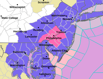
Well I see Chester and Delaware counties and Southwestern New Jersey are getting coal for Christmas no Winter Storm Watch here lol. This goes right along with my thinking earlier Winter Weather Advisory SE Pennsylvania and Winter Storm watches north and northeast. The more important snow line I-76 points northwest, north, and northeast. -
Boxing Night Snow/Sleet/Ice Dec 26-27 Storm Thread/Obs.
Kevin Reilly replied to Mikeymac5306's topic in Philadelphia Region
That’s going to be solid warmth streaming in out of the west-southwest aloft east-northeast at the surface gotta keep that NE flow CAD for this one or game over in regards to pure snow. -
Boxing Night Snow/Sleet/Ice Dec 26-27 Storm Thread/Obs.
Kevin Reilly replied to Mikeymac5306's topic in Philadelphia Region
As I see it now my inkling is that the block is too far east and like most times over past few years the cold air is booted NE and outta of southeastern Pennsylvania. I think our true potential down here in southeastern Pennsylvania is 1-3” of snow then flip to sleet / freezing rain. This is kind of a repeat from yesterday just more energy and moisture to work with. It’s clear favored areas are NE Pennsylvania as far south as Doylestown points east and northeast from there. 4-7” Doylestown points NE. I would go winter weather advisories southeastern Pennsylvania western New Jersey and winter storm watches northern Montgomery County Bucks County points NE. Subject to change but best guess right now. it would take a fairly strong block to keep the torch of airmass in the central and western United States from advancing east bound. -
Boxing Night Snow/Sleet/Ice Dec 26-27 Storm Thread/Obs.
Kevin Reilly replied to Mikeymac5306's topic in Philadelphia Region
So, 3-5" of sleet then freezing rain Let's Go!! -
E PA/NJ/DE Winter 2025-26 Obs/Discussion
Kevin Reilly replied to LVblizzard's topic in Philadelphia Region
1.2” in Media all roads covered for a time While snowing 34 start dropped to 31 then back to 33 when it tapered. -
E PA/NJ/DE Winter 2025-26 Obs/Discussion
Kevin Reilly replied to LVblizzard's topic in Philadelphia Region
Hmm how about that 12z gfs -
E PA/NJ/DE Winter 2025-26 Obs/Discussion
Kevin Reilly replied to LVblizzard's topic in Philadelphia Region
Actually, more snow East, North, Northeast the warm air is punching in from the west southwest. -
E PA/NJ/DE Winter 2025-26 Obs/Discussion
Kevin Reilly replied to LVblizzard's topic in Philadelphia Region
Umm hmm ?? Kind of out there in a tight window we shall see?
-
E PA/NJ/DE Winter 2025-26 Obs/Discussion
Kevin Reilly replied to LVblizzard's topic in Philadelphia Region
Yea White Christmas is essentially dead outside of Kamu’s lingering snow pile. I could see some localized street flooding and stream rises from the next system Thursday into Friday. 11 degrees this morning in Media. Currently 22f with a 12f dewpoint identical numbers from 24 hours ago. Snowpack doing its refrigerator thing. -
I think what he means is a northwesterly flow turning more west-northwesterly aloft with winds turning southwesterly and overriding the cold air at the surface. Oh, and we are on the far southwestern edge of the cold air that is slowly being eroded from the west in time.
-
E PA/NJ/DE Winter 2025-26 Obs/Discussion
Kevin Reilly replied to LVblizzard's topic in Philadelphia Region
Mood flakes have arrived here in Media with a slight dusting on all surfaces. Officially a trace today 22f humidity 75% 16f All snow showers moving NW to SE across the area. -
Saturday night/Sunday 12/13-12/14 Jawn
Kevin Reilly replied to Ralph Wiggum's topic in Philadelphia Region
Residual warmth from the River keeping temps .4 to .7 degrees higher literally maybe kept the snow wetter more compacting I suppose? -
Saturday night/Sunday 12/13-12/14 Jawn
Kevin Reilly replied to Ralph Wiggum's topic in Philadelphia Region
partly cloudy with 6.5" of new snow, windy gusting to 30-35 mph temp: 19f dew point 12f It's going down tonight Total Snow: 6.5" Total Snow Year: 6.8" -
Saturday night/Sunday 12/13-12/14 Jawn
Kevin Reilly replied to Ralph Wiggum's topic in Philadelphia Region
A few left over flakes sun has made an appearance. 30f humidity 96% dew point 29f snow total: 6.5” snow total for the year: 6.8” power out unfortunately -
Saturday night/Sunday 12/13-12/14 Jawn
Kevin Reilly replied to Ralph Wiggum's topic in Philadelphia Region
Power outages here -
Saturday night/Sunday 12/13-12/14 Jawn
Kevin Reilly replied to Ralph Wiggum's topic in Philadelphia Region
Moderate to heavy snow 32f humidity 97% dew point 32f Total 5.1” I’m starting to get concerned about power outages trees are really loaded. See some reports of power outages on ring bell around here within a few miles -
Saturday night/Sunday 12/13-12/14 Jawn
Kevin Reilly replied to Ralph Wiggum's topic in Philadelphia Region
Moderate to heavy snow huge flakes. 32f humidity 96% dew point 32f closing in on 5” trees are absolutely loaded wires sagging. You cannot see through the trees walls of white. -
Saturday night/Sunday 12/13-12/14 Jawn
Kevin Reilly replied to Ralph Wiggum's topic in Philadelphia Region
Moderate Snow all surfaces covered except paved but beginning to cave. 33f humidity 77% dew point 26f -
Saturday night/Sunday 12/13-12/14 Jawn
Kevin Reilly replied to Ralph Wiggum's topic in Philadelphia Region
Snow picking up in intensity that was pretty quick temp still 35f dewpoint 25f car tops and grass caving. -
Saturday night/Sunday 12/13-12/14 Jawn
Kevin Reilly replied to Ralph Wiggum's topic in Philadelphia Region
Light snow has begun in Media 35f dewpoint 25f Right on schedule to the minute lol -
Saturday night/Sunday 12/13-12/14 Jawn
Kevin Reilly replied to Ralph Wiggum's topic in Philadelphia Region
That looks like a cold front? Temp here has fallen to 34f now down from 40f dewpoint from 26f to 24f wind has shifted NNE at 9 mph. -
Saturday night/Sunday 12/13-12/14 Jawn
Kevin Reilly replied to Ralph Wiggum's topic in Philadelphia Region
Cloudy first flakes a few flurries at the moment 36f dewpoint 25f so I guess zero rain here let the games begin! Looks like though dry air punching in from the southwest so these flakes are just temporary as everything is pulling off to the northeast. Drove up from Delaware along Route 202 to Pyle Road to Foulk Road saw the first flakes along that route as well and continued till I go home in Media. -
Saturday night/Sunday 12/13-12/14 Jawn
Kevin Reilly replied to Ralph Wiggum's topic in Philadelphia Region