GaWx
-
Posts
17,544 -
Joined
Content Type
Profiles
Blogs
Forums
American Weather
Media Demo
Store
Gallery
Everything posted by GaWx
-
0Z 12/24 (orange) barely makes major SSW status with it a hair under 0 m/s at the end and still dropping. The 0Z CDN ens mean (blue) is at 2 days in a row at a major. But the 0Z GEFS mean never gets below +17.
-
The 0Z 12/24/23 EPS holds onto the very good chance for a major SSW Jan 3-9. Also, I count ~12 extreme cases (sub -15) throughout the run:
-
And we can now add the 12Z GFS op to the split SSW list. Here’s the way I look at the SPV: -Weak much better than strong -SSW better than not -Major SSW better than minor. E 1/3 of US affected most. -Split major seems to be somewhat better than displacement major -Split during El Niño may be best of all though displacement during Nino normally good enough
-
Here is a screenshot of a list of major SSWs broken down by split vs displacement: noteworthy splits include 1/30/58 (El Nino), 1/8/68, 2/2/73 (El Nino), 1/9/77 (El Nino though not listed), 1/2/85, 12/8/87 (El Nino), 1/18/03 (El Nino), 2/9/10 (El Nino), and 1/2/19 (El Nino; too recent to be listed here but was a split). Note that there have been 7 split SSWs since 1958 during El Nino that were early enough to impact met. winter and all 7 were notable in terms of subsequent cold and/or historic E US winter storms:
-
The 0Z EPS is also hinting at a split per this that just came out from BAMWx (left map is 0Z EPS hour 360 at 50 mb) meaning all three of the latest major ensemble means are leaning toward a split now:
-
So does the 0Z GEPS (CDN ens):
-
The 3.4 OISST is not going in the right direction if you want a super Nino:
-
This 0Z 12/24 GFS is almost definitely a major SSW (we'll find out by afternoon) and is the first run I can recall with an actual split of the SPV.
-
I found this but have no details about it. What do they mean by “following”? The 1-3 week period immediately following is sometimes mild in the E US. Is that period included. If so, the average cold anomaly would be colder than this once past 1-3 weeks. And is this just for majors? Are these C or F? But this suggests that the coldest over land in the entire hemisphere between 30 and 40N by far is over the E US vs the warm anomalies over much of Eurasia/W US. The coldest is over the MidAtlantic/SE/lower MW. That’s why I don’t think about where the coldest will end up. So, get the major and the cold should come, especially during El Niño:
-
The potential major SSW is getting closer! Once again, the EPS has numerous major SSWs 1/3-9 with the highest concentration 1/4-7. So, the Euro and CDN are both are both saying very good chance for one 1/3-9 with the GEFS at ~ half as high a chance as the other two for then. I see ~17 sub -15:
-
12Z GEPS still has strong signal/much stronger signal than 14 days prior to 2/16/23 for a major SSW ~1/6. But for same timeframe the 12Z GEFS still has a much weaker signal than GEPS. Model battle! I expect GEFS signal will strengthen in coming days.
-
Today’s 0Z CDN ens mean has gone from yesterday’s +2 to +1 for 1/6-7 to today’s -3 to -5 for 1/7-8 (lt blue line), solid signal for a major SSW within a few days of 1/6 or 14 days out: To compare, what did the GEPS mean show in advance of the 2/16/23 major? At 14 days out or the 2/2/23 run, it still had it way up at ~+15 on 2/16 (see below). It didn’t show it negative until 2/6/23, only 10 days out. So, the current GEPS signal out 14 days is much stronger vs where it was 14 days before the 2/16/23 SSW:
-
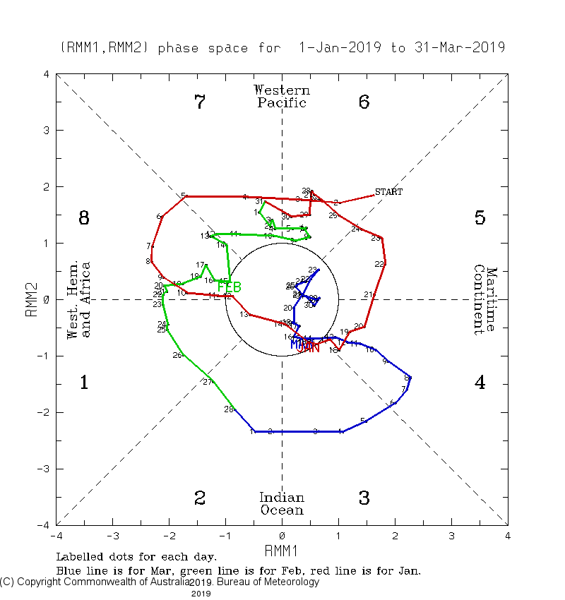
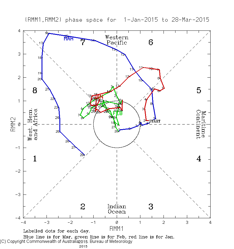
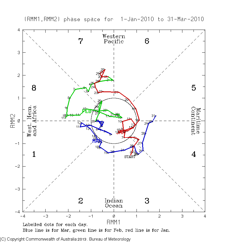
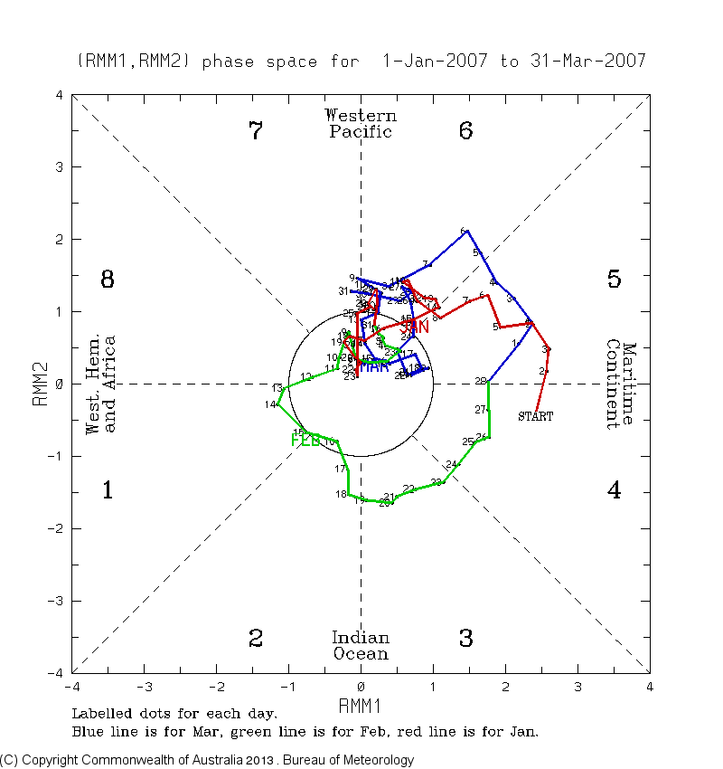
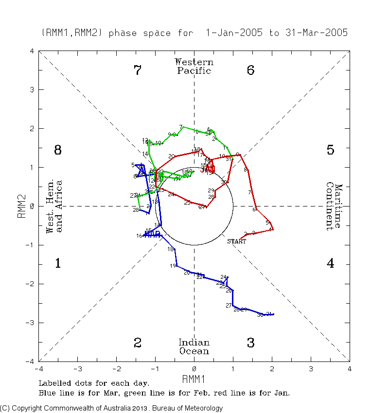
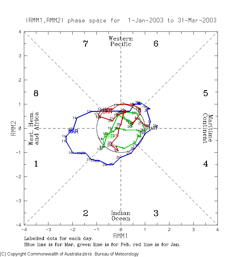
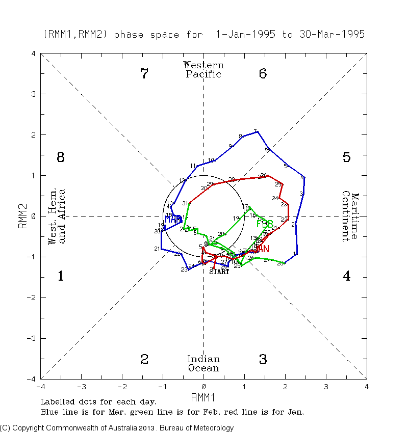
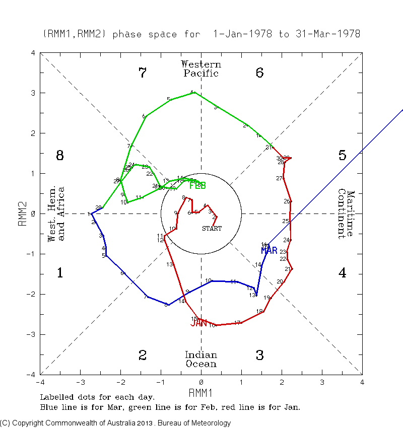
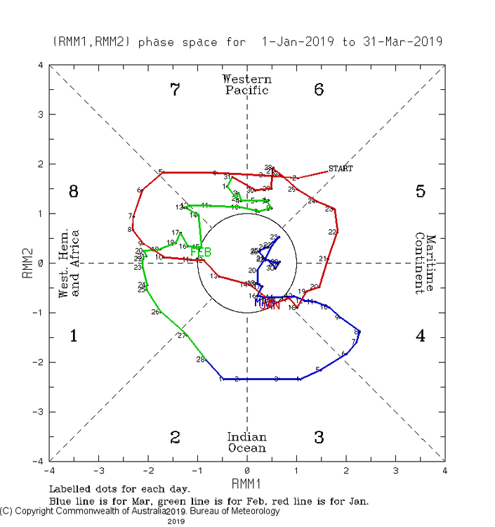
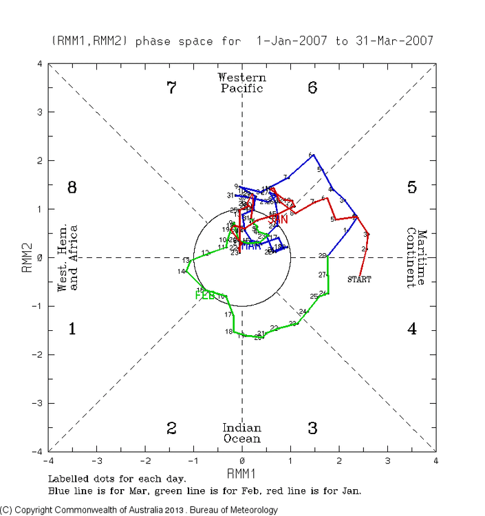
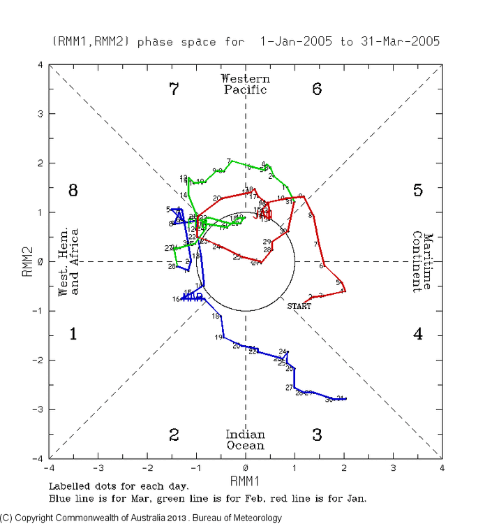
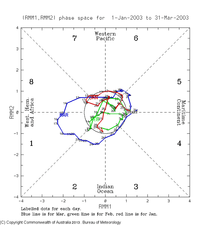
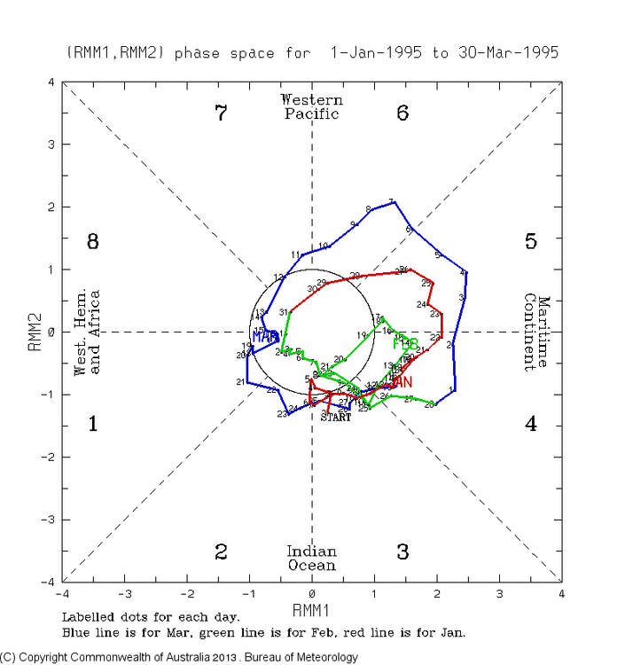
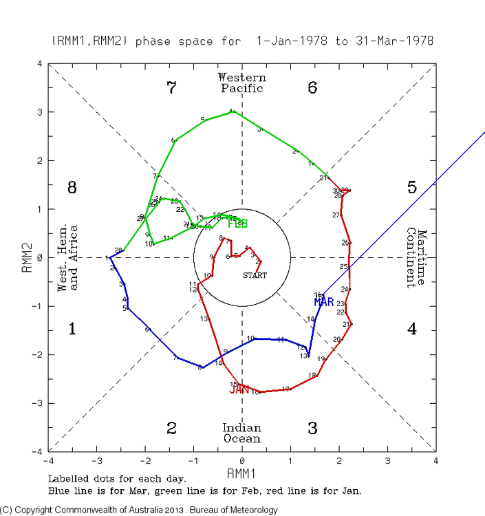
Regarding the periods in El Niño Jans with outside circle MJO phase 4-6 for 5+ days, were they all dominated by mildness in the SE? I’ll look at RDU: 1. Jan 17-30, 2019: no as it averaged 2 BN 2. Jan 1-13, 2015: No as it averaged 3 BN 3. Jan 4-6, 18-21, 2010: No as it averaged 3 BN 4. Jan 1-15, 26-30, 2007: Yes as it averaged 7 AN 5. Jan 1-12, 15-19, 30-31, 2005: Yes as it averaged 5 AN 6. Jan 1, 8-12, 2003: Yes as it averaged 4 AN 7. Jan 12-28, 1995: Yes as it averaged 5 AN 8. Jan 20-31, 1978: No as it averaged 8 BN ——————— So, for the 8 El Niño Jan periods with 5+ days of outside COD phases 4-6, RDU was mild during only half of them. To be fair when averaging the 108 days, I do get 1.5 AN. However, even that is only slightly warmer than normal. Conclusion: Although it could very well be mild during non-weak phases 4-6 in El Niño Jans in the SE, don’t assume it will because that was the case for only half of the 8 cases: 2007, 2005, 2003, and 1995. The years 2018, 2015, 2010, and 1978 were cool to cold. This tells me to not assume either way.


-
The answer just came out based on the following chart: 0Z 12/22/23 GEPS mean (light blue line) has a mean 60N 10 mb wind of +1 m/s on 1/6-7:
-
New Euro Weekly 10 mb mean wind: though likely not quite as many there are still lots of members with a major SSW in early Jan, especially Jan 3-9. Also, for the full run, the # of extreme SSWs (sub -15) increased back up to ~15:
-
In the E US, I found that the SE US and lower Mid Atlantic have been most affected on average. As I’ve posted before, I did an analysis of major SSWs that affected El Niño winters since 1957-8 (excluded the two in late Feb because that’s too late to impact met. winter) and found all of them to have had a 3-7 week long period of BN temp domination in those areas starting 1-3 weeks after the major SSW date. The NE is also usually affected though not always.
-
Today’s 0Z GEPS mean at 384 looks very close to a major SSW. If not, I think the mean wind is only a little over 0. I’ll find out later:
-
1. Today’s WCS OISST dropped slightly to +2.01. It continues to not move much overall (no real trend). It remains to be seen whether or not the ERSST based NDJ ONI ends up +2.00+. Keep in mind that the Nov ERSST was slightly warmer (less than 0.10) than the Nov OISST: 2. OHC has been dropping sharply since late Nov per this. So, barring another sharp warmup soon, Nov will end up the peak month:
-
December 2023 Mid/Long Term Pattern Discussion: Let it Snow!
GaWx replied to John1122's topic in Tennessee Valley
Don’t forget that the great cold snap of 12/23-26/22 was actually during a high amplitude phase 5: -
Keep in mind that the MJO, though quite important, can sometimes be overruled by other factors. Whereas outside the COD phase 5 is on average one of the warmer Dec phases for the SE, that is just an average. Just last year the coldest air of the winter in the SE by far was during the period Dec 23-26, which was during high amplitude phase 5! (see below). The main driver was a very strong -AO teaming up with a moderate +PNA along with a strong -EPO that had just ended. There actually was a moderate +NAO. And it was during La Niña! At least this year we have El Niño and its favoring of a +PNA. And then we’ll see if we can get a -AO and perhaps a -NAO. So, looking ahead to Jan, if the MJO really does go into moderate phases 4-6, I wouldn’t bet the ranch on it being mild in the SE then. No recent Euro Weeklies run has had it mild.
-
December 2023 Mid/Long Term Pattern Discussion: Let it Snow!
GaWx replied to John1122's topic in Tennessee Valley
Indeed, phase 3 on average is near normal for temperatures in NC in winter: https://www.cpc.ncep.noaa.gov/products/precip/CWlink/MJO/Composites/Temperature/DJF/combined_image.png -
The first run of the Euro Weeklies that covers 1/29-2/5 has BN temperatures in the SE. This is after the prior 4 weeks all being NN to BN with BN every week over FL. Coldest two weeks are Jan 1-8 and Jan 29-Feb 5. All weeks remain normal to wetter than normal with strongest anomalies far SE and no dry areas in any week. So, El Niño climo ftw! In addition, keep in mind the increasing chance for a major SSW ~1/3-6. Starting 1-3 weeks after that there’d be a tendency per climo during El Niño for the SE to have BN temperatures dominate for a 3-8 week period per analogs. If you look at major SSW analogs, the SE US pretty much leads all areas of the US with the strongest BN anomalies. Here’s 1/29-2/5 temperatures:
-
Importantly, today’s Euro Weekly 10 mb wind didn’t backtrack from yesterday’s surprisingly (except to @40/70 Benchmark )weak SPV run and still has numerous members with a major SSW Jan 3-6 (more concentrated over shorter interval), which is 13-16 days out. The 2/16/23 major SSW was first strongly honed in on 13 days out for comparison. Once again, note the spike up just before the plunges. Also, I count 12 extreme (sub -15) vs 22 yesterday:
-
That’s especially the case the further south one goes, like down in the SE. Looking at some past cold SE winters, much of Canada was AN. If AN or even much AN Canadian air is brought down fast enough and thus not allowing for too much modification before arriving, that air can more easily be BN to even much BN the further south one goes due to warmer normals. Check out the average correlation of temperature to a +PNA in DJF for a good illustration. A +PNA is essentially a W to C Canadian block. It being warm vs normal where there’s blocking is common:
-
The post I was responding to mentioned how warm Dec has been for the US as a whole anomalywise. My response was to show how the degree of warmth for many who post here regularly will end up unimpressive as the warmest anomalies are elsewhere. That’s especially the case in the SE, where we’re barely AN or NN MTD now and are likely headed to an overall NN Dec. Even way down here in the deep/coastal SE I’ve already had 8 lows in the 30s or lower this month, pretty normal for Dec here. It was 27 yesterday. I didn’t say anything about snow as I was strictly addressing the Dec warmth that had been mentioned. Obviously snow for the east has been largely nonexistent to this point.