

wx2fish
-
Posts
2,631 -
Joined
-
Last visited
Content Type
Profiles
Blogs
Forums
American Weather
Media Demo
Store
Gallery
Everything posted by wx2fish
-
Preliminarily ... a medium impact partial Miller B, Friday
wx2fish replied to Typhoon Tip's topic in New England
39 here now. Looks like it stopped just short of you, but you didn't miss much. I flipped for like an hour, but we lost the good rates and wasted most of it. Just got some slush. Derry north got more. -
Preliminarily ... a medium impact partial Miller B, Friday
wx2fish replied to Typhoon Tip's topic in New England
Euro caved east at 6z, then the nam jumped west at 12z. It could be interesting tonight if it tracks more over the Cape vs Weymouth (like the 12z hrrr), but well see. -
Preliminarily ... a medium impact partial Miller B, Friday
wx2fish replied to Typhoon Tip's topic in New England
CF on my head. Up to 37.5, from 32.5 -
Preliminarily ... a medium impact partial Miller B, Friday
wx2fish replied to Typhoon Tip's topic in New England
Slipped back up to the 34F here with light rain. Station to my south in Pelham is up to 37F. CF might be oscillating back northward a bit in this area. -
Preliminarily ... a medium impact partial Miller B, Friday
wx2fish replied to Typhoon Tip's topic in New England
It did pretty well furher south, but NH seems to be a fail around the MHT area -
Preliminarily ... a medium impact partial Miller B, Friday
wx2fish replied to Typhoon Tip's topic in New England
Coastal front looks pretty close to the MA/NH border. Still seems to be sinking south a little for the time being.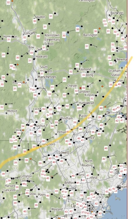
-
Preliminarily ... a medium impact partial Miller B, Friday
wx2fish replied to Typhoon Tip's topic in New England
Went from 39 to 34 here as the CF sunk just south. Mixing over to snow -
Preliminarily ... a medium impact partial Miller B, Friday
wx2fish replied to Typhoon Tip's topic in New England
It sunk just south of me, still 36 but dropping. Looks like it 32 in Bedford -
Preliminarily ... a medium impact partial Miller B, Friday
wx2fish replied to Typhoon Tip's topic in New England
Yeah the 15-21z timeframe looks quite a bit colder than 18z across the interior -
Preliminarily ... a medium impact partial Miller B, Friday
wx2fish replied to Typhoon Tip's topic in New England
HRRR gone wild Sat AM. Id be willing to make some sacrifices to the weenie gods for that solution -
Preliminarily ... a medium impact partial Miller B, Friday
wx2fish replied to Typhoon Tip's topic in New England
Definitely interesting looking on Sat -
Preliminarily ... a medium impact partial Miller B, Friday
wx2fish replied to Typhoon Tip's topic in New England
Yeah I agree. Without much elevation I'd be happy with advisory slop -
Preliminarily ... a medium impact partial Miller B, Friday
wx2fish replied to Typhoon Tip's topic in New England
If MHT ever managed 16" and I got 0" 5 miles south the christmas tree and presents would be on fire. -
Preliminarily ... a medium impact partial Miller B, Friday
wx2fish replied to Typhoon Tip's topic in New England
Definitely a tick colder. Gets pretty interesting even around MHT -
Snowing pretty good with a quick coating in this little streamer
-
Looked near peak yesterday around Franconia Notch. Well past peak up in Pittsburg, almost stick season up there.
-
Mine have a pretty short exterior run. Most of it is in the attic or basement. All depends where you put the condenser outside
-
Up in Pittsburg and saw pixie flakes for a while this morning. Didn't make it up into the real high terrain to see if there was any accumulation
-
37F on johns site near the 1st. I'm sure the freezing level is hitting ridges on the east side of the lake
-
2.25" so far with steady rain. Only need another quarter inch to match my total for the last 2 months
-
A nam run we love to see
-
I've started to really enjoy warm Septembers. After labor day the boat and 93 traffic dies down. We get to take back NH after the summer.
-
Definitely a little boundary pressing WSW, pseudo sea breeze/backdoor type. Winds gone ENE here and the temp is slipped a couple degrees and the dew jumped.
-
I was ready to burn it all down all earlier. May have chucked a few frozen weenies at Scott's accord when he drove by exit 3
-
0.0" today, 0.64" on the month. Unreal. Couldn't be any more different than last summer when seemingly every CB dropped over an inch


