-
Posts
4,732 -
Joined
-
Last visited
Content Type
Profiles
Blogs
Forums
American Weather
Media Demo
Store
Gallery
Everything posted by Windspeed
-
ASCAT shows the axis is definitely sharpening. Uncertainties for any west wind yet SSE of the wave break boundary. Haven't checked recon schedule, but it won't be too long before we have real-time obs from Barbados to help assist analysis as 94L passes to the North.
-
2021 Atlantic Hurricane season
Windspeed replied to StormchaserChuck!'s topic in Tropical Headquarters
Starting to get interesting for sure. The convective envelope could stand to improve further, but clearly it is trying as I type this. As has been said earlier, let's see if some good bursting today can tighten up that broader low level circulation. There's some nice convection trying within the eastern region of the low level spin. This may go through genesis as it is moving through the Lesser Antilles. Would not be surprised to see PTC advisories as early as this afternoon. -

2021 Atlantic Hurricane season
Windspeed replied to StormchaserChuck!'s topic in Tropical Headquarters
What? Dude, chill. Ramble all you want but at least make sense. Ida by early October? I mean, unless our closest star suddenly and rapidly expands into a Red Giant phase, I'd imagine we'll have the "I" storm before the end of September. -

2021 Atlantic Hurricane season
Windspeed replied to StormchaserChuck!'s topic in Tropical Headquarters
Orange for both 93 and 94L in the Five Day Outlook. I like 94L's chances a little better regardless of Greater Antilles interaction. Better upper atmospheric conditions in the short-term for organization to evolve. Obviously the thermodynamics are there. 93L has some VWS to contend with that may continue to force stable air into it from the N. That could change however as it gains some longitude. At any rate, multiple surface circulations within a larger monsoonal trough is difficult for models to find cohesiveness and consistency between runs. May take another few days to iron out. -

2021 Atlantic Hurricane season
Windspeed replied to StormchaserChuck!'s topic in Tropical Headquarters
The western most region of low level vorticity within the decaying extension of the monsoonal surface trough has my greatest interest at the moment. It looks a little suspect to be increasing in organization tonight. -

2021 Atlantic Hurricane season
Windspeed replied to StormchaserChuck!'s topic in Tropical Headquarters
Oh look, it must be early August. The same usual suspect is here to provide their informative long range seasonal analysis based on a single numerical operational model output. You know if they can keep this up every year, they're eventually going to be correct.- 967 replies
-
- 12
-

-

-

2021 Atlantic Hurricane season
Windspeed replied to StormchaserChuck!'s topic in Tropical Headquarters
The 18z GFS and HAFS-B globalnest have very robust cyclonic signatures with the strong MCS about to advance off Africa over the next few days. Monsoonal flow has become robust into the Cabo Verdes. Latitude for wave break and axis will still be critical for downstream development however as SSTs are still quite marginal due west of the islands. A surface trough more SSW of CV would obviously increase potential, as 27°C+ SSTs better support thermodynamics needed for cyclogenesis. -

2021 Atlantic Hurricane season
Windspeed replied to StormchaserChuck!'s topic in Tropical Headquarters
Well anytime both the ECMWF and GFS ops are sniffing development out of the MDR, take note. But this is the midrange middle August, therefore climatologically time for the switch to flip on. There are some decent AEWs that will be rolling off over the next week and the WAM flow looks to extend and tug on the ITCZ to 40W during that time. Enjoy the quiet, doesn't look like it's going to last much longer. -

2021 Atlantic Hurricane season
Windspeed replied to StormchaserChuck!'s topic in Tropical Headquarters
The question posed was to explain the lack of Cat 5 landfalls in Texas. I think it's a combination of factors, some just luck/chance, some geography. You mentioned Katrina and Rita. Those were Cat 5s that would eventually make landfall as 3s, but not in Texas. Harvey and the 1900 Galveston Hurricane are most likely the most powerful landfalls in Texas within record-keeping range. Hurricane Beulah in 1967 attained Category 5 status and would eventually make landfall as a 3 in Texas. Allen reached 5 multiple times but only made landfall as a 3 near Brownsville as well. Let us not forget that Florida generally wins the Category 5 lottery for a reason. It is 1) a peninsula surrounded by Gulf Stream Loop & Current and 2) located within a higher frequency of high-end 'cane paths due to trade winds. But the idea here is that it would be unwise to assume hurricanes do not and will not strike Texas at Category 5 intensity. Edit: Should have mentioned Carla '61 along with Harvey and the Galveston 1900 above. Also a correction: though the point of landfall was recorded in extreme SW Louisiana, Rita's weaker western eyewall was across the border in Texas. So it's a little cheap on my part to not consider Rita a Texas 'cane. -

2021 Atlantic Hurricane season
Windspeed replied to StormchaserChuck!'s topic in Tropical Headquarters
Geography does play a major role. Most TCs that strike Texas develop out of the WCARIB and must deal with land interaction of the Yucatán. This limits organizational/developmental time before RI can top out maximum potential energy. I am sure VWS relationship with dry continental airmass does play a role on occasion. However, typically westward vector is supported by easterly mid-level steering flow across the GOM. That should supercede dry airmass ever so often with these TCs. There have been some close calls however in documented history and almost certainly there have been many 155+ mph landfalls pre-colonialization. I'd wager Harvey would have attained Category 5 had it had more time over the GOM. Its structure was absurd well into post-landfall. The shallow shelf is sometimes plenty deep enough with 28°+C SSTs to support a Category 5 that is moving at a favorable rate of motion. To the point, though we have not seen a Cat 5 strike Texas, it will eventually happen again whether we as humans are still around to witness it. -

2021 Atlantic Hurricane season
Windspeed replied to StormchaserChuck!'s topic in Tropical Headquarters
Convection is waning where the more vigorous MLC was located earlier. That may delay progress a bit more in line with modeling. We'll see where it's at during the diurnal maximum tonight. Convection may redevelop. -
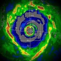
Felicia at 18z on Tuesday per HWRF. I suspect it will weaken even faster than the HWRF is modeling due to very dry stable airmass being advected into the core with the increasing southwesterly VWS.
-
Felicia indeed still looks impressive. Some WSW VWS should begin increasing over the next 24-36 hrs. This combined with a subtle decrease in thermodynamic support should bring on a gradual weakening into abrupt faster weakening into Tuesday. The HWRF shows a period of rapid weakening on Tuesday as the MLC gets decoupled.
-
No. There is certainly nothing official with regards to forecast discussion or analysis that suggests this is a Category 5. TAFB Dvorak analysis hit T6.5/127 kts per discussion and ADT numbers are about 10 kts lower. Felicia has already maxed out for an annular-type TC within the current thermodynamic environment. It would need to drop a bit more latitude and reach warmer SSTs to get any stronger. Even with cooler upper tropospheric temperatures, Felicia's core is riding a 26.5 to 27°C isotherm. Its eyewall has probably maxed out potential intensity at its current westward vector of motion.
-

2021 Atlantic Hurricane season
Windspeed replied to StormchaserChuck!'s topic in Tropical Headquarters
1) Nowhere will you ever find data to support classification or naming of an ULL. The sarcasm here is noted, but out of bounds. As far as areas of interest, there are plenty of examples of mid-level systems and cold core upper troughs transitioning to warm core systems. But that is for another discussion. 2) Satellite technology and ever increasing shipping traffic now enable us to recognize and discern warm core and assymetric warm core cyclones that warrant more subtropical classifications than in years past. There is no agenda here except to supercede and fulfill a critical obligation by the TAFB division of the National OCEANIC and Atmospheric Agency. That role is to protect life and property for maritime shipping interests, not just the inhabitants of coastlines. If a system meets the criteria, it gets classified. This is a scientific agency, there are rules, but technology and subsequently guidlines evolve over time. 3) Going to nip this in the bud right here. Any more talk of an agency misleading or lying to fit a political agenda, much less climate change, will be removed. This is not the thread for such discussion.- 967 replies
-
- 12
-

-

-
lol..
-
A symmetrical doughnut...
-
Ooof..
-
-
Already at the "F" named storm and we didn't even make a thread. We have not seen anything crazy at this point, but it's not exactly been quiet either. Felicia is intensifying and expected to become a hurricane by tomorrow. No threat to land. I am sure someone will want to post "bye" when it dissipates over cooler surface waters next week.
-

2021 Atlantic Hurricane season
Windspeed replied to StormchaserChuck!'s topic in Tropical Headquarters
There's a good discussion ongoing about 2021 following suite with 2020, '18, '16, that late September through October will experience peak activity versus a traditional climo-favored late August to mid September peak. This would not surprise me in the least. Especially if there is robust MDR warming in September versus typical late July-August and heft poleward motion of the ITCZ. A slightly below average MDR SST anomaly is currently in place. That may be the only other negative factor against early CV August activity beyond PVs and SAL. Though we are still weeks away and slightly below mean SST data sets can reverse pretty quickly given a few weeks of decreased low level easterlies. -

2021 Atlantic Hurricane season
Windspeed replied to StormchaserChuck!'s topic in Tropical Headquarters
With a -ENSO in place, an active August may hinge upon whether the EPAC enters a suppressed regime while a strong WAM continues in the EATL. If PV anomalies are somewhat in check across the Atlantic Basin, then CV season likely kicks off early. Current Bermuda High placement is already a potential harbinger of Caribbean Cruisers. Any subtropical development could threaten Florida, but any deep MDR development likely would maintain Caribbean potential. I expect more Caribbean hurricanes this season. Weak PV anomalies and a suppressed EPAC would obviously increase their ACE potential by mitigating VWS. To further add upon this, note these graphics by Ben Noll: Keep in mind that sinking air is only prohibitive of TC development in the genesis stage. With modeled subsidence in August across the EPAC, this may squash TCG occurring there and subsequently qualm outflow induced VWS across the Caribbean and Antilles into the Subtropical Atlantic. Likewise, with atmospheric instability / lift in the EATL coinciding a +WAM, TCGs will be supported from frequent healthy tropical disturbances rolling off the African Continent. Granted, limiting factors such as strong PVs and SAL can still work against potential TCs crossing the MDR, but if those factors are limited, a TC will have no issues intensifying into the WATL. Timing of occasional favorable CCKWs enhance these regardless of overall airmass regime. At least at this point, an active August looks possible, and certainly a hyperactive September is in the cards as well. -

2021 Atlantic Hurricane season
Windspeed replied to StormchaserChuck!'s topic in Tropical Headquarters
[emoji102] -

2021 Atlantic Hurricane season
Windspeed replied to StormchaserChuck!'s topic in Tropical Headquarters
You joke but... In all seriousness, a cool upper level low can allow for some pretty intense lapse rates and thunderstorms this time of year over the hot coffee thermos that is Florida. -

2021 Atlantic Hurricane season
Windspeed replied to StormchaserChuck!'s topic in Tropical Headquarters
Convective organization consolidated into an eyewall is usually seen and needed to sustain the vortex of the tropical cyclone at ≥74. But that isn't always the case. We have seen eyewalls form in core convention in moderate tropical storms that were only producing 50-55mph winds. Likewise we have examples of hurricanes with broken cells around the vortex that were not producing a solid or even semicircle eyewall. Again, it is not merely the appearance and structure that classifies a hurricane; in situ wind data (or satellite derived estimates, if that is only available) and a closed warm core surface vortex are the requirements for TC classifications.

