Heisy
-
Posts
9,445 -
Joined
-
Last visited
Content Type
Profiles
Blogs
Forums
American Weather
Media Demo
Store
Gallery
Everything posted by Heisy
-

Historic Lake Effect Event?! 11/17-11/21
Heisy replied to BuffaloWeather's topic in Upstate New York/Pennsylvania
Just had lightning! . -
Historic Lake Effect Event?! 11/17-11/21
Heisy replied to BuffaloWeather's topic in Upstate New York/Pennsylvania
Beautiful plume. . -
Historic Lake Effect Event?! 11/17-11/21
Heisy replied to BuffaloWeather's topic in Upstate New York/Pennsylvania
Radar brightening up over the Lake. So jealous. Enjoy . -
Historic Lake Effect Event?! 11/17-11/21
Heisy replied to BuffaloWeather's topic in Upstate New York/Pennsylvania
Couldn’t switch my work schedule enough to make it out. Jealous. Extremely jealous. Enjoy it! Be safe . -
Shame this isn’t a few weeks later. As is almost close enough. .
-
Couple 6z euro members and control dive that N/S energy around the 20th far enough south to generate some snow for the region. PNA spike aids in this. Something to keep an eye on. Potent N/S shortwaves are always modeled poorly imo. .
- 852 replies
-
- 2
-

-
- hurricane
- tropical storm
- (and 1 more)
-
I’m considering going! A LES monster is still on my bucket chase list. All depends on work, and how fast I think I can leave Buffalo for Philly. .
-
Upstate/Eastern New York-Into Winter!
Heisy replied to BuffaloWeather's topic in Upstate New York/Pennsylvania
I’m going to do what I can, all depends on work schedule Thanks all! Most snow I ever saw in one event was around 30”. I couldn’t imagine how awesome an experience of 2-4” rates and 36-48” would be . -
Upstate/Eastern New York-Into Winter!
Heisy replied to BuffaloWeather's topic in Upstate New York/Pennsylvania
I could leave late Wednesday and drive there all night. If I’m able to call out Friday then I wouldn’t work again until Sunday at 6pm which I probably wouldn’t be able to move. I don’t know if it’s possible to get back to Philly by Sunday. Are they able to clear the roads to make them at least passable to get outside the LES effected region? I own a normal sedan. Unless I decide to rent a truck/SUV. . -
Upstate/Eastern New York-Into Winter!
Heisy replied to BuffaloWeather's topic in Upstate New York/Pennsylvania
Been wanting to chase a LES event for a long time. I’ve been all over the country for major events, but for some reason LES hasn’t worked out. I work Friday but could possibly call out/switch my schedule around and get there from Thursday-Saturday. Contemplating it heh. . -
Guess only hope is a delay considering it’s moving in now and it’s only 6pm. Could probably play through intermittent showers at a 9:30 start
-
Yea regardless whether he’s good or not, just a nostalgic thought. My morning ritual during my high school days back during those years was wake up at 6, read his newsletter, check wright-weather, and double check the LR AVN/MRF whatever it was called back in those days haha (GFS) BTW this year I don’t plan any chases up near you guys unless there’s some crazy HECS like 2013 level on the models. I got my fill during last years blizzard. I would like to go LES chasing. Never experienced a major LES event. can’t believe we just about finally made it to November, let’s gooooo.
-
I remember getting his morning newsletter back in the 2000-2007 years. Used to love waking up reading that before school haha.
-
This was the first event I experienced after joining the wx community. About a week or two prior there was a massive cold front and blocking formed. Dec 30 2000 was originally a Miller A HECS on the models in the medium to long range, then it morphed into the Miller B it became. I remember texting Ji at around 3am the day of the event and him saying he couldn’t see a cloud in the sky which definitely didn’t bode well lmao.
-
Ray has a great archive website, google “Rays winter storm archive” it will be the first link: Unfortunately he stopped during the 2013 season, but from 93-13 he has every map from every winter storm in the region. He also has a great YouTube channel with TWC/local news broadcasts from a ton of events. Pretty cool if you’re in a nostalgic mood. Every fall I go on my own nostalgia trip to get in the mood for winter. Question: what’s the deal with the model upgrades this fall. What exactly is going on with GFS & EPS. I remember reading last winter that the eps would upgrade to 50 more members and better resolution. The OP would also go out farther during 6/18z runs. .
-
Thanks, Yea if I remember the tweet last year from ecmwf they were adding like 50 eps members or something, better resolution, and possibly longer forecasts at 6/18z .
-
Anyone know when the EPS upgrade is happening? I remember last year reading some news it was getting a large upgrade. Only a few months if hell left! .
-
Really contemplating chasing this thing, am I that insane? Maybe
-
There’s actually a lot of ensemble members on the gefs, eps, Canadian that have a shot of snow day 8. I’m not ready to give up yet, let’s reel it in
-
I saw a 76ers logo and had to respond! I only worry about Boston and Brooklyn. Any other team in the east we should be relative favorites. We would probably go 7 games with Miami but I don’t fear them. Boston has the best record in NBA since January 1 and Brooklyn would be hella motivated to beat us. The oddest statistic this year is our home vs away record. We used to be unstoppable at home. Just odd. Team is still getting used to playing with each other. Bench is an issue but hopefully Doc shortens it during the playoffs.
-
Yeah there’s some hinting of a west based block forming. Could be possible to sneak something in between 25-1st well see
-
March 2022 Obs/Disc: In Like a Lamb, Out Like a Butterfly
Heisy replied to 40/70 Benchmark's topic in New England
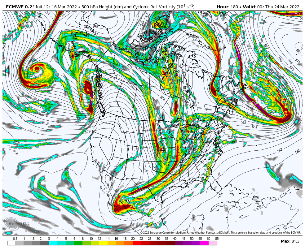
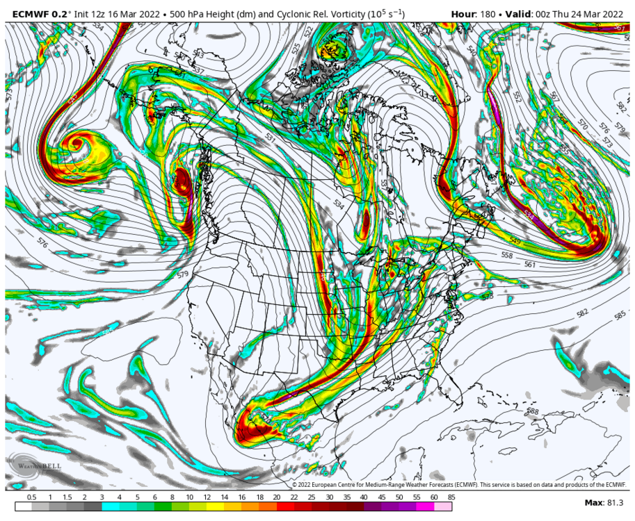
Yea I would ignore the specifics at this range, but there is a signal on the overall pattern for Davis straits block last week of the month. Unfortunate for those people dying for warmth -
March 2022 Obs/Disc: In Like a Lamb, Out Like a Butterfly
Heisy replied to 40/70 Benchmark's topic in New England
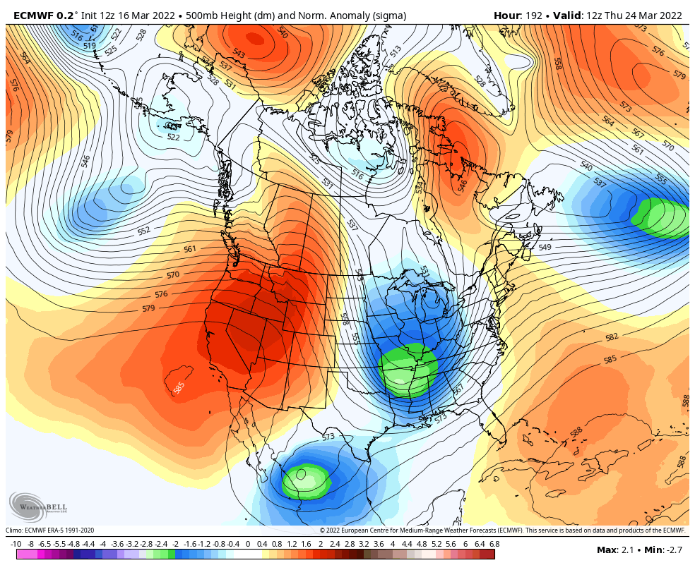
That’s actually pretty interesting setup around 25th if we can get that blocking ULL to trend to a better spot there’s a temporary block setup with a pna ride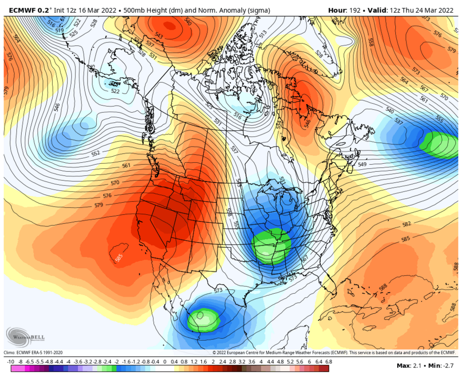
-
Im keeping an eye on it all the way from Philly. Went to Estes park last year for the march storm and enjoyed it. Would love another Denver chase!
-
Post winter depression in full effect… Ugh