frostfern
-
Posts
2,267 -
Joined
-
Last visited
Content Type
Profiles
Blogs
Forums
American Weather
Media Demo
Store
Gallery
Everything posted by frostfern
-
It would be nice to have a progressive MCS coming out of the west for once this year. I get tired of going between a ridge where the good convection is always NW, and a subtropical cutoff where it's just cloudy muggy soup with not a lot of instability to work with.
-
Yea. They were slow movers. Where it did rain it rained hard, but a lot of places missed out. There wasn't a ton of thunder here, just occasional soft peals, but the rainfall rates were very tropical. There was just under 2 inches here yesterday, but there was far less just a few miles north and west.
-
There is a stationary rain band stalled IMBY. The feature really isn't moving at all. SE side of town is getting absolutely inundated. Surprised no flash flood warning. The puddles are huge already.
-
Hard tropical rains today. Just a little soft rumbling thunder, but major downpours. Looks like no drought any time soon this year.
-
Well. People take tornado warnings very seriously in Indiana. Not so much in northern Michigan.
-

2022 Short/Medium Range Severe Weather Discussion
frostfern replied to Chicago Storm's topic in Lakes/Ohio Valley
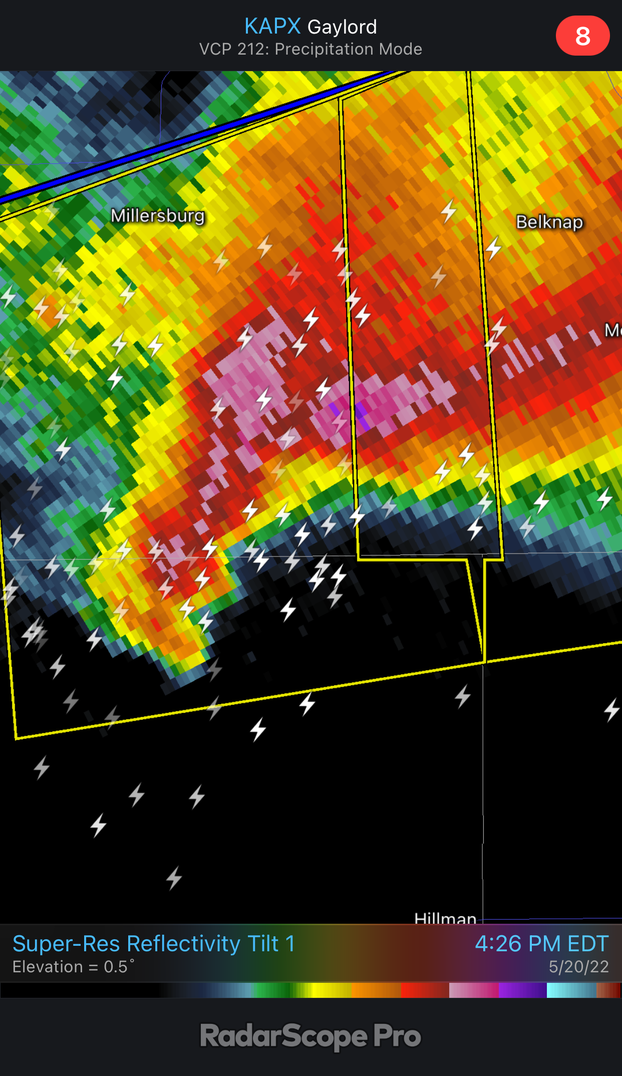
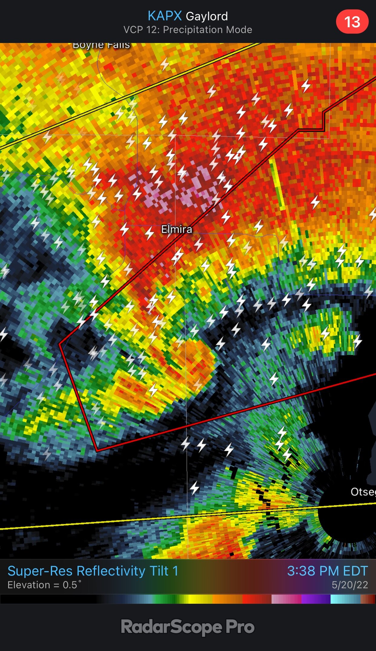
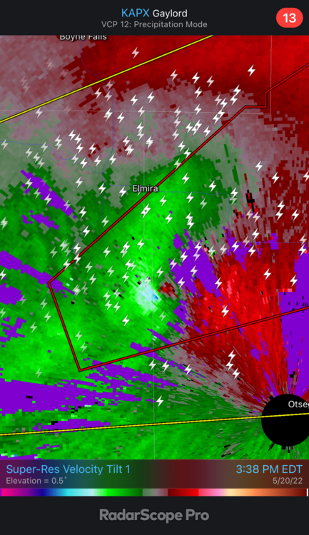
Hi-res radar loops I made of Gaylord tornado event. Basic Reflectivity Loop Close Up Radar Analysis -
2022 Short/Medium Range Severe Weather Discussion
frostfern replied to Chicago Storm's topic in Lakes/Ohio Valley
I'm getting Flagstaff AZ. The page isn't working. -
2022 Short/Medium Range Severe Weather Discussion
frostfern replied to Chicago Storm's topic in Lakes/Ohio Valley
Does anyone know where I can find the 3PM sounding before the tornado? Also archived local mesoanalysis at a similar time. I'm making my own writeup. -
2022 Short/Medium Range Severe Weather Discussion
frostfern replied to Chicago Storm's topic in Lakes/Ohio Valley
I remember looking at the radar. I was watching the cell for about 45 minutes. It seemed like there was some contamination of the velocity field from birds or something at one point. It was hard to read. They usually don't issue a tornado warning until they see evidence of a strong circulation near the ground. I recall the circulation was evident a few scans before the tornado warning went out, but it was fairly broad looking. I have seen many similar looking circulations that produced minor RFD wind damage but never produced a proper tornado. I do feel that given the classic look of the cell and the path of the circulation towards a populated area, they could have put out the warning a little earlier and risked a false alarm. It's a tough call though. Hindsight is 20/20. I think I will download the full radar loop. -
2022 Short/Medium Range Severe Weather Discussion
frostfern replied to Chicago Storm's topic in Lakes/Ohio Valley
I think I ate at the Culver's that got wrecked three years ago. -
2022 Short/Medium Range Severe Weather Discussion
frostfern replied to Chicago Storm's topic in Lakes/Ohio Valley
I made the right decision. I saw how fast the predicted storm motion was. I didn't have a partner/driver. I'm not going to chase tornadic storms moving at 55 mph through the woods alone. Need AT LEAST two people in the vehicle. -
2022 Short/Medium Range Severe Weather Discussion
frostfern replied to Chicago Storm's topic in Lakes/Ohio Valley
The terrain goes from 580 feet elevation near Traverse City to 1350 feet at Gaylord. That amount of elevation gain was enough to hold back the marine layer (like a dam) and tap much greater surface instability as the storm moved inland. This allowed the elevated circulation to intensify and dig down to the surface. -
2022 Short/Medium Range Severe Weather Discussion
frostfern replied to Chicago Storm's topic in Lakes/Ohio Valley
The clear air CGs are impressive. Also looks like significant hail again. Too bad its in the middle of the woods.
-
2022 Short/Medium Range Severe Weather Discussion
frostfern replied to Chicago Storm's topic in Lakes/Ohio Valley
Guess its good Im not there. It moved dangerously fast through a lot of trees. Hard to find an escape if caught. -
2022 Short/Medium Range Severe Weather Discussion
frostfern replied to Chicago Storm's topic in Lakes/Ohio Valley
Its looks bad news. I saw a debris signature. -
2022 Short/Medium Range Severe Weather Discussion
frostfern replied to Chicago Storm's topic in Lakes/Ohio Valley
Monster circulation headed straight for Gaylord. I didn’t go. -
2022 Short/Medium Range Severe Weather Discussion
frostfern replied to Chicago Storm's topic in Lakes/Ohio Valley

-
2022 Short/Medium Range Severe Weather Discussion
frostfern replied to Chicago Storm's topic in Lakes/Ohio Valley
-
2022 Short/Medium Range Severe Weather Discussion
frostfern replied to Chicago Storm's topic in Lakes/Ohio Valley
I’ve given up on chasing. Cells will be moving NE way too fast. -
2022 Short/Medium Range Severe Weather Discussion
frostfern replied to Chicago Storm's topic in Lakes/Ohio Valley
I have only heard one semi-close lightning strike this season. Late April I think. All it does is drizzle lately. -
2022 Short/Medium Range Severe Weather Discussion
frostfern replied to Chicago Storm's topic in Lakes/Ohio Valley
Almost everywhere in Michigan is crappy chasing territory. I will not drive under any core. In the past I drove up behind a small core and picked some 2" stones off the ground for pictures. Honestly, watching a squall line come in off Lake Michigan is usually what constitutes a good "chase" for me. It just hasn't happened this year so far. -
2022 Short/Medium Range Severe Weather Discussion
frostfern replied to Chicago Storm's topic in Lakes/Ohio Valley
I don't think anything will get to the thumb until after dark. I need to see what SPC is saying tomorrow. -
2022 Short/Medium Range Severe Weather Discussion
frostfern replied to Chicago Storm's topic in Lakes/Ohio Valley
What do y’all think of the chance for supercells tomorrow afternoon over Lower Michigan. Im thinking of driving up to Gaylord as the higher terrain seems more likely to break the cap. I’m thinking if something can get going it has the chance of dropping plains-style hail which is rare around here. It could also be a cap bust though. -
A training t-storm event seems possible for SE Lower MI Friday night into Saturday. The wind field is almost parallel to the front and instability will linger all night and into Saturday morning where the dewpoints are pooled up along the front. The models all trended towards the front slowing down and stalling.
-
2022 Short/Medium Range Severe Weather Discussion
frostfern replied to Chicago Storm's topic in Lakes/Ohio Valley
Most likely for me too. These strong EML caps don't break over Lake Michigan during the afternoon. The convection will probably happen after dark to the SE because the front slows down.