

frostfern
-
Posts
2,267 -
Joined
-
Last visited
Content Type
Profiles
Blogs
Forums
American Weather
Media Demo
Store
Gallery
Everything posted by frostfern
-
I thought there was one or two very warm days early November 2020, upper 70s even here in Michigan.
-
So. Did anyone take the day off to go surfing in southern Lake Michigan?
-
Snowfall helps me, and I don't think it's just the weenie factor. All that reflected white light adds a lot of light. I just really don't care for solid overcast tacked on to the rapidly shortening days. It's a shock after such a sunny summer. I remember those kinds of rains in the PAC NW when the Pineapple Express got going in October/November. Near the mountains it can rain 0.25-0.5" per hour for 12+ hours.
-
Kind of annoyed the more interesting weather is missing to my southwest, but I still get the dark clouds and dreary cold of course.
-
It's getting to me here too. SAD is already starting. I will be happy when it snows, but this dark dreary drippy s*** is useless.
-
Here's a series of questions to gauge preferences. Thought about just putting this in poll format, but doing it this way encourages more discussion. Do you prefer..... A snowstorm in winter or something out of season? If it's the latter, early or late? Best is with a good 6" base already present... so deep winter is best. January or February. I love a deep snowpack. No pre-storm thaw or slushy/icy changeover. Wet snow, dry/fluffy snow, or something in between? It's all good. Just no changing to rain or sleet. Also, lake effect is often too fluffy and totals always feel artificially inflated to me. Light/calm winds, or windy conditions while it's snowing? It's all good. Blizzard conditions are cool, but I'll take calm snow falling straight down too. Continuous snow, or do lulls not matter as long as amounts end up as expected? 12" in 12 hours, or 18" occurring over 36 hours? 12" in 12 hours is more impressive. 18" in 36 hours isn't impressive when the net water content is only 0.7" because it's all lake effect. Bitter temperatures, or just cold enough to stick well during the storm? Bitter cold onset usually means a dry east wind and virga problems, and small crystal sizes even when the snow does reach the ground. If there's an arctic airmass involved, it should wrap in from behind. The front end should not be too cold or totals are impacted by the dryness. Storms on holidays/your birthday/some other meaningful day, or are dates irrelevant? Don't really care. If living in a lake effect area, would you rather have a synoptic or lake effect storm of the same amount? Synoptic all the way, though I do appreciated lake effect on the back end that adds to the totals. 100% lake effect totals always feel artificially inflated to me, especially when they occur over many 12 hour measurement intervals. It can easily snow 4" every 12 hours, but only be 0.12 water content for every 4" that falls. When another 4" falls on top of that first 4" fluff, it contracts to 6", but another full 4" is recorded from the board. Then the next 4" only adds another 2" to the depth, because even more settling occurs with all the air space to fill. The end result is the official storm total snow measurement is way over the final depth on the ground. Lake effect snowfalls are the most beautiful in light wind conditions though. The snow has a tendency to stick to trees, railings, roofs, etc... in a very uniform way, creating a classic pristine winter look. The totals just feel inflated in comparison to synoptic big dog storms with actual water content.
-
GHD 2011 was awesome. Other storms have had larger totals, but it's the only storm in my lifetime where the accumulation occurred in a short period ( well over a foot in a 12 hour period ) accompanied by true blizzard conditions. Most storms the "blizzard force" wind only comes on the back end when the snow is winding down, or the snow accumulates over several periods stretching well over 24 hours. With that storm everything happened at once, mostly in a 12 hour period. It was a good storm, even with *only* 14-17 inch totals here as opposed to the 20" in Chicago. Getting 20"+ lake effect fluff over 72hours just isn't the same as a genuine synoptic storm.
-

2022 Short/Medium Range Severe Weather Discussion
frostfern replied to Chicago Storm's topic in Lakes/Ohio Valley
I guess there was a wind gust or two. The stronger lake instability never materialized. Cold aloft was kinda marginal even for thunder. -
Impressive lake instability this evening. Waterspout and graupel weather. Too bad it will probably be just after dark.
-
2022 Short/Medium Range Severe Weather Discussion
frostfern replied to Chicago Storm's topic in Lakes/Ohio Valley
Not severe, but this was fun. https://www.youtube.com/watch?v=WBly6mLOlrw -
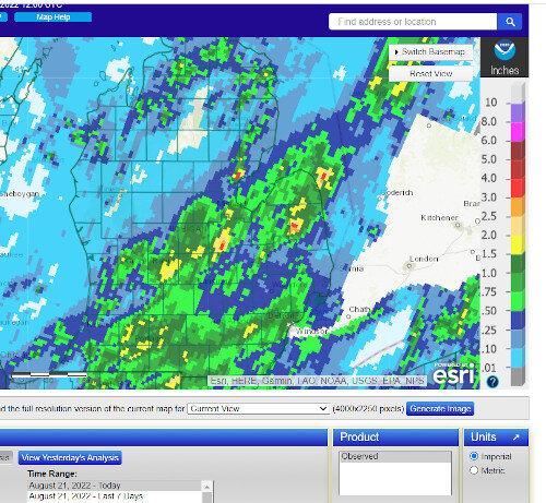
I only get 0.37" rain from today. Line was narrow on the back-building end despite having a lot of lightning. The lake might aid in a decent soaking next week though, if a cold ULL goes overhead as shown. Graupel showers and waterspouts on the lake... maybe.
-
Hard to believe its so hot just SW of here. It only got into the 70s for about an hour between rounds of convection here.
-
Just had the loudest storm of the year IMBY. Probably over a dozen strikes within a mile or less, 2 almost right on top of me. Glad I was home to unplug the appliances. I feel like larger apartment buildings are usually heavily grounded and protected from surges but houses with above-ground wires can get zapped.
-
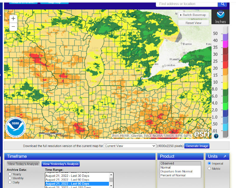
Could use some rain again here. Under 0.5" since September 1st. Still looking decently lush from August rains, but I noticed a lot of trees are showing brown and dropping leaves. Its especially bad on the east side of the state that missed most of the August rains. Hard to say what kind of color show it will be this year. Last year was terrible.
-
2022 Short/Medium Range Severe Weather Discussion
frostfern replied to Chicago Storm's topic in Lakes/Ohio Valley
From my reading that effects polarity more than density. Higher bases with shallower warm cloud depth favors positive polarity, which usually means lower strike density overall (all other things being equal, positive strikes drain much more charge per flash, and are thus less frequent). In this case the LCL was ground-hugging in my area (probably 500m or less), so that would seem to favor very deep warm cloud layer and negative polarity. -
2022 Short/Medium Range Severe Weather Discussion
frostfern replied to Chicago Storm's topic in Lakes/Ohio Valley
The lightning wasn't super cooperative. A lot of anvil crawlers and occasional big ground-shaking +cg thunderclap on the back side, but low clouds were in the way most of the time. I still haven't exactly figured out what parameters you need to get really dense cg+ strikes. It's usually slightly sub-severe storms that are the loudest though. -
2022 Short/Medium Range Severe Weather Discussion
frostfern replied to Chicago Storm's topic in Lakes/Ohio Valley
Luckily the persistent layer of low clouds limited the gust potential some in my area. It certainly rained hard here though and there were some ground-shaking lightning strikes. -
2022 Short/Medium Range Severe Weather Discussion
frostfern replied to Chicago Storm's topic in Lakes/Ohio Valley
I took my camera out of my air 74 degree air-conditioned house to maybe record some lighting as the storms rolled in. The lens instantly got all foggy. -
Up to just 5.5 inches for the month of August now. Could have used some of this rain in June and July. Evidence of the early summer drought is harder to find at this point. Some trees are have patches of yellow/brown leaves. More splotchiness with a lot of weed and crab grass in my yard as I hate watering. I water my baby trees and flowering plants, but screw the grass if it doesn't rain.
-
2022 Short/Medium Range Severe Weather Discussion
frostfern replied to Chicago Storm's topic in Lakes/Ohio Valley
It didn't seem anywhere close to severe IMBY, but apparently the GRR ASOS measured a 58 mph gust. It looks like the clearing line was pretty much right at KGRR when the storms rolled in. Murky all day here with a temperature stuck around 78-82, but there was more filtered sun and temps into the middle 80s just a little south. -
This was what June and July were like here. The switch finally flipped at the beginning of this month. Grass is spring-green again, but there's still evidence of stress to some of the younger trees.
-
Hoping to get rocked with the incoming MCS. Surviving well so far. The instability is on the wane going east, but there's decent shear and the lake isn't all that cold anymore.
-
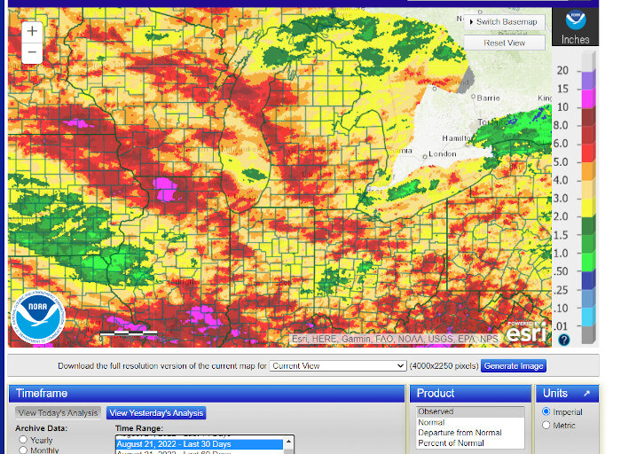
Lots of 30-day wet and lots of 30-day screw zones on the map now, even though it has evened out some over the long haul. Spots of SE Iowa and the Saginaw Bay area are pretty deep in the hole for the entire summer at this point though.
-
There's quite a variation around Michigan too now. Still extremely dry over much of Northeast Lower MI, as well as the "Lake Erie Shadow" zone between Detroit and Toledo. I don't know how accurate these radar estimates are, but the showers and storms yesterday put down buckets over extremely localized spots. Kind of a tropical pattern with scattered slow moving storms blossoming in the afternoon with outflow / lake-breeze interactions determining where the heaviest rain falls.
-
So El Niño pattern decides to show up in the fall. Lovely. Happy there's been good rain so far this month as compared to last, but 2022 has been such a bore-fest.

