

cbmclean
-
Posts
3,065 -
Joined
-
Last visited
Content Type
Profiles
Blogs
Forums
American Weather
Media Demo
Store
Gallery
Posts posted by cbmclean
-
-
3 minutes ago, cbmclean said:
The thing I find least believable about the whole episode is the apparent foot of snow in December. Next you'll tel me the NAO was negative at that time.
-
20 minutes ago, psuhoffman said:
Yea they did that. My dad was at the game. He said it was the end of a miserable season after several miserable seasons and the team was playing like garbage. Then the eagles took a fan from the stands dressed up like Santa that looked drunk and awful and decided to walk him out on the field at halftime and the fans booed him and some threw snowballs at him. It was also a long time ago and in response to an awful owner who was ruining a team for a passionate fan base. Not excusing it.
I’ve been at some eventful games. I was at the body bag game and the bounty bowl. I was there when they pelted the Cowboys with snowballs nonstop the whole game. I’ve been to some giants games that turned into royal rumbles in the stands. Someome dragginf a dead deer carcass around the stadium ramp behire a game against the bucs. I was at the Monday night game that was the impetus to have a courtroom in the stadium. Someone shot a flair gun across the stadium, there were so many fights security couldn’t keep up, and a group of fans charged the field and attempted to throw beer at the referee after a bad call. But all of that was a long time ago also. 80s and 90s. And that was a different time when stupid shenanigans weren’t taken so seriously. If you look at arrests at nfl football games it was about the same in most Midwest and northeast cities. comparable at eagles, Browns, Steelers, Giants, and patriots games at that time. Lest we forget back then the patriots had a night game and after the game fans tore down the goal posts and carried them out of the stadium and electrocuted themselves when they ran them into power lines. Ray Didinger who was a beat reporter at the time went to a giants game and had his windows busted and a F philly sign left in his car. There was a lot of stupid back then. But I think between the Santa thing that got national press and then Buddy Ryan being a pompous ass it became an easy scoop.
But my more recent experience with the eagles is positive. I’ve been to dozens of games in the last 20 years since Laurie bought the team without that kind of atmosphere anymore. It’s still loud and passionate but less of the borderline crazy violence. What I remember lately is how the whole city comes together for the team. Unlike lots of other places the eagles own Philadelphia. The city stops for games. It’s not just some fans. Almost everyone is an eagles fan. Little girls scream eagles chants and random people start singing the fight song on the street. I remember walking back to broad street from the liberty bell the day of the super bowl and my 2 year old son was singing fly eagles fly the whole way and everyone we passed gave him high fives and started joining in. Even when I’m not in philly if I pass an eagles fan when my wearing my hat I’ll get a chant or a high five. That night of the SB random people were hugging me on the street and singing songs. It’s like a family thing but with a family of 4 million people. Im sure there are similar experiences for other fan bases. But that’s what I love. It’s a family tradition and a positive community experience. Yea one idiot ate horse sh!t and some other moron ran into a pole and that got a lot of press but imo most of the widespread really bad behavior was in the distant past.
https://www.snopes.com/fact-check/philadelphia-fans-boo-santa-claus/
-
48 minutes ago, psuhoffman said:
While I think the eagles fans rep is often a cheap exaggerated story
So I was wondering, what was the story when they supposedly booed Santa Claus?
-
 2
2
-
-
45 minutes ago, psuhoffman said:
Wouldn’t it be nice to see Doug get to coach a healthy playoff team? I am convinced he is a great coach. It’s amazing what he has done 3 years with a mash unit by the end each time. Would be nice to see him with an Eagles team that somewhat resembles the “plan” when season starts in the playoffs.
Fun fact: In his rookie year, Doug Pederson was QB for the Dolphins on the day that Don Shula passed George Halas for the record for most coaching victories. That was the year Dan Marino tore his Achilles and earlier that game Scott Mitchell had separated his shoulder. So I bet a lot of Dolphins fans have a soft spot for Doug.
-
6 minutes ago, Bob Chill said:
At least it's on its own now. EPS/GEPS combo looks quite a bit different and have been slowly improving each run. I'll toss the gefs until one of the others start to agree
Watch this be the time where the GEFS gets its revenge and crushes the EPS.
-
1
-
-
30 minutes ago, Bob Chill said:
NA is our acronym for North America. Full latitude trough. Get that neg tilt and close off on the way north and it's fireworks for someone. It was just an interesting panel. Total fantasyland stuff though
Whoops: neophyte mistake.
-
Just now, Ralph Wiggum said:
Looks like a full lat trof neg tilt to it. Big storm signal for the East....somewhere.
Well he mentioned the North Atlantic trough specifically, that was what I thought he was talking about.
-
15 minutes ago, Bob Chill said:
It's atypical but this is a big storm setup for the eastern US in general. One of the biggest NA troughs I've seen. Obviously it's an op out of range but this is an impressive panel

How does that work to help the E Conus?
-
Down goes Wentz. Apparently the Pacific Doom Blob is so strong it's even affecting east cost football.
-
 1
1
-
-
1 hour ago, psuhoffman said:
I'm hoping that Kellog's is paying well for that very subtle product placement for Crispix in the last pic.
-
11 hours ago, psuhoffman said:
I almost never bet on the Eagles because I know I am biased but if I was going to put money on the game I would take the Eagles. By no means do I think its a lock, Eagles arent a dominant team by any stretch and they are very banged up, but a few things make me think this is a favorable matchup for them.
I think it is highly unlikely they turn the ball over 5 times again. It was a one score game last time despite 5 turnovers.
The Eagles defense is very good at home.
Seahawks defense isn't that good....I would be more concerned given the Eagles offensive limitations with the injuries against a defense that could totally squash them.
Seahawks are run heavy and the eagles strength is stopping the run
Seattle run's a lot of audibles at the line and that wont work in a playoff game in philly
There have been 8 instances where a 9-7 or worse Division winner played a 11-5 or better wild card team...and the division winner is 6-2 in those games.
Eagles are 5-0 all time as a playoff underdog at home.
I think in the NFC Seattle is the best matchup for the Eagles. Still I only give them a slight advantage but if I did bet it would be on Philly.
Next week they probably get destroyed on the road.
If the just weren't so depleted by injury, I think they could make some noise.
As it is, which is more likely, epic pattern flip or another eagles super bowl?
-
12 hours ago, psuhoffman said:
Sure but I am not going to spend as much time studying our fail patterns as I did our winning ones. I just don't hate myself that much. But I know off the top of my head what years and patterns really suck balls and put together a quick profile of some of the worst ones.
First of all... while we can score a fluke snowfall in many patterns...the truth is there are way more looks that just don't work out often then there are ones that do. We are south of the mean northern stream jet in winter most of the time. It takes an anomalous pattern to get snowfall. The warm wet cold dry thing is real. Often in winter the only time the cold boundary gets south of us is after a wave passes and the flow behind it presses the boundary south. But without a favorable pattern the return flow ahead of the next wave is likely to press the boundary back to our north before it gets here. Basically the average storm track is to our north. But most patterns with some luck and some bootleg factor (like a Hudson ridge) working for us we can occasionally get snow. But most patterns without luck we can easily go with no snow as well.
Bad Luck
On top of that...sometimes we can just get unlucky in a perfect pattern. A storm gets suppressed, the next one is just slightly too warm, another develops off the coast...next thing you know we wasted a 2 week perfect pattern. The winter of 2007 would fall into that category. Look at this H5 pattern for Feb
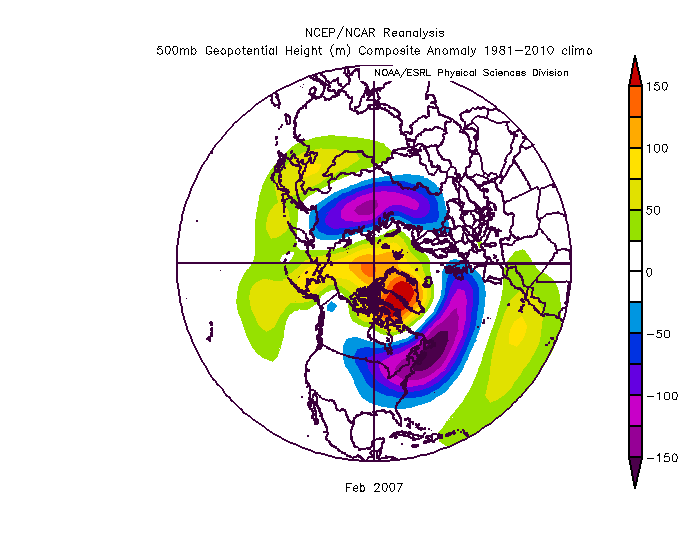
March was pretty good also for a good portion of it. THe first half was pretty crappy and I will use December 2006 as an example of a crap look later but even with a wasted Dec into Jan if you told me that would be our look for Feb and Mar I would take my chances. ANd while we did get some snow...we didn't cash in on the full potential and so the winter went down as a below avg snowfall year. There were 2 blockbuster coastals that year...one in Feb and one in Mar and both were just SLIGHTLY too warm at the mid levels and the big snowfall ended up a little NW of us. THere was one storm that had big potential but a PV lobe at the wrong time squashed it. And a couple others just failed to reach potential and ended up minor snowfalls. We mostly wasted a really good pattern. That has happened other times as well.
On top of that, even more common, we waste a look that is OK, not great but definitely not awful and end up with a really bad result. YOu can look at the H5 for a year like 1981 and say...that looks ok. Not epic but you wouldn't think a horrible dud winter was coming, but it was. Truth is snow here is anomalous and luck wrt timing and discreet features that fall under the pattern level have a LOT to do with our results. Call it luck or chaos but pattern is only half the fight.
So all that said I will focus on a couple patterns that just really really really suck and give us almost no chance for a significant snowfall, luck be damned.
Some general observations
First of all, any pattern that features a +NAM state without either a perfectly placed east based EPO ridge...or a really favorable PNA ridge is a fail pattern. We can score in a +NAM pattern but only with pacific help. If the AO/NAO are both awful (like right now) and the pacific inst in a very favorable state...that is a total fail pattern. That is because anything that pumps a SE ridge without resistance up top will not end well here.
Additionally there is seasonal variance. The NAO is way more important later in the season. As the temperature profile tends to get colder across N. Amer later in the season and wavelengths start to shorten in Feb, and water temperatures cool along the coast, blocking on the atlantic side can influence and overcome the pacific pattern more. Early in the season we really need pacific help to have a good chance.
But bad looks can be very temporary or transient so what patterns tend to give us that and lock in for an extended period of time. I assume that is what you mean because we can have a bad week even in the best winters...but what looks spell doom for a really long time and eat up a big chunk of our winter window.
AK Vortex Pattern
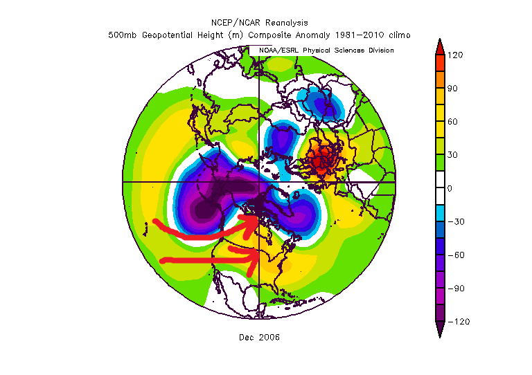
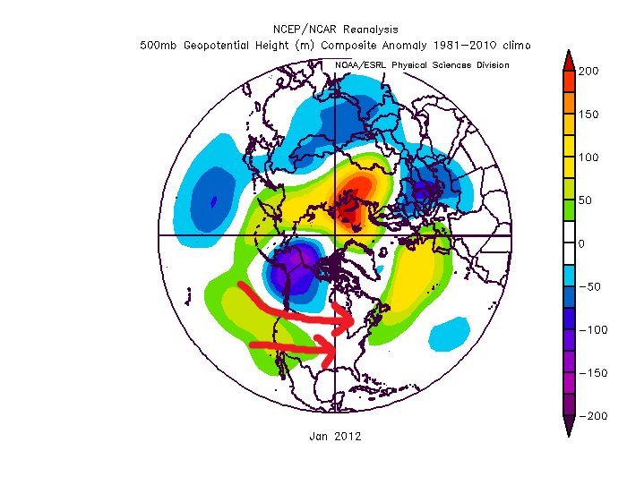
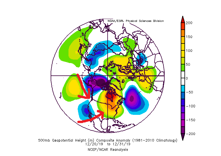
The first is an AK vortex pattern. This one is especially a killer early in the season. It can be overcome from Mid Jan onward but only with NAO blocking. Early it tends to be a problem even with blocking. Without blocking this look is a total fail pattern all winter long. You pointed out earlier that 2012 was a good example. December 2006 was also a perfect example. The last 10 days also featured this problem.
I have the h5 below...the issue with this pattern is the flow under the AK vortex floods the continent with warm pac air. Without ideal blocking on the NAO side that mild air will flood across and not only will we be warm but there won't be any cold air anywhere near us. This pattern can take a LONG time to recover from. Even once the pattern improves we can waste a week just getting cold back onto our side of the hemisphere.
Dec 2006
January 2012
Last week...
Pac Ridge +NAM pattern
The next one is the one we are about to go into according to all guidance. How long it lasts is yet unknown...but this is the absolute worst pattern we can possibly ever get into in winter, both because of how bad it can be...numerous examples of completely snowless months with this pattern...but also because of how stubborn it can be. Frankly this is the most common season destroyer of all the patterns. This one accounts for the majority of our total fail winters.
This is the composite of many of our total fail years that fit this description, the Jan/Feb of 1950, 1951, 1959, 1973, 1989, 1990, 2002, 2008, 2013. All of these were single digit snowfall years at BWI except 1990 but all the snow fell that year BEFORE the pattern set in early January.
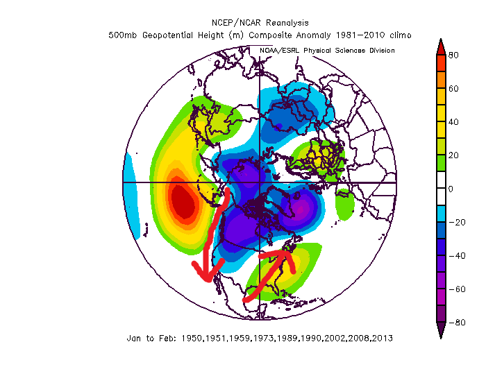
look familiar?
This one is real simple...that pac ridge digs the trough out west...which pumps the ridge in the east. Simple wave physics. Without extreme blocking to offer resistance that will push the thermal boundary well to our north.
The reason this pattern can be so stubborn is an anomalous central pac ridge is usually a primary effect not a secondary effect. Meaning usually it is being driven by the tropical pattern in the central pacific and Maritime Continent regions. It's not a result of something that caused something that caused something...and so on. It is the direct result of a very major driver of the global pattern. IF that driver doesn't change...that ridge can park there for months. And that ridge loads a wave pattern over north america that sucks for us. It can only be overcome with extremely -NAM state to suppress the SE ridge.
Too much of a good thing
The last one I will cover that has accounted for some total crap years is the "too much of a good thing" pattern. I almost didn;t include this one as its a weird anomaly. This one is rare, usually only happening during a super nino. And if you just glance at the h5 it doesn't look that bad. And...it does increase the potential of a blockbuster storm. We had this pattern a few times and sometimes we get lucky and time up just enough cold to get a HECS. But if we dont....we can go long stretches simply too mild to get snow. The best examples are 1983 and 1998. Yea we had the HECS in 1983 but imagine if that one storm had not hit. The rest of the prime part of that winter was a total wasteland. Basically like 1998.
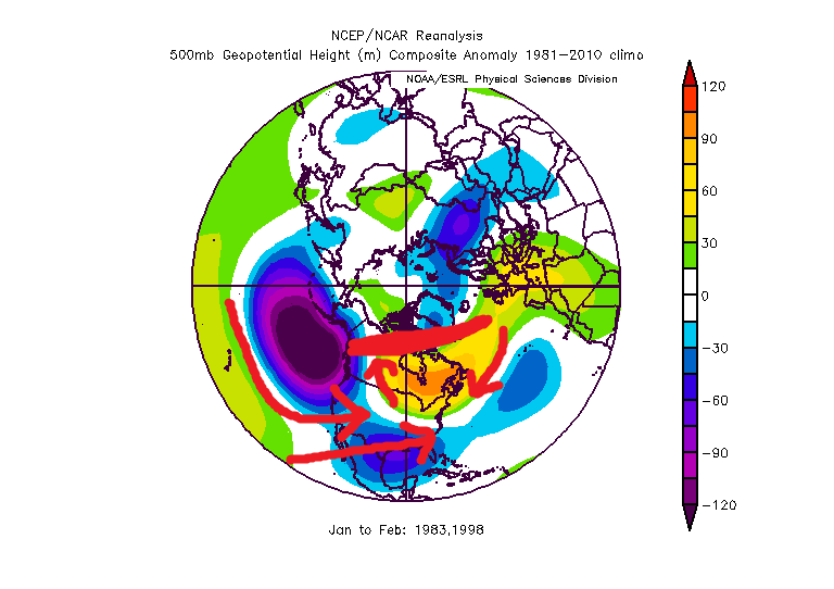
The issue is hard to see just from h5 but its kinda there. The super nino. That pac trough is actually a bit much...if it was a little less anomalous and near the Aleutians not so expansive it would be perfect, and that is the typical moderate nino look. But in this case that extreme trough in the pac is flooding the CONUS with mile air. THe trough over the gulf is the juiced up STJ but the flow under the pac trough combined with the ridging across the US/Can border has flooded the US with mild air and cut off any cross polar flow to press cold into the pattern. The result is just a mild pattern with a good storm track that yields cold rain. It's not a mild look. Just not cold enough to snow. Pretty miserable really. This one suck but its not that common so I wouldn't worry too much. Plus it gives us the best chance of all the fail patterns at a fluke storm, and a BIG one at that. But since 1998 was one of our worst winters I figured I would throw in an explanation of why.
There are other fail patterns...pretty much any look with a SE ridge and no blocking... but those first 2 are the main ones that can last a long time and wreck months or even a whole season. If anyone wants to add more great but I am depressed enough now so have a good night. Hope this was what you were looking for.
Very informative, thanks.
-
1 hour ago, Stormpc said:
Mersky. Who is that? He has been meticulously picking through psu's posts, and others, to become quite annoying. I don't need his interpretations of others contributions. Where did he come from? I'm tired of him.
Ignore button
-
All right PSU, big game tomorrow: battle of the birds. Seattle seems to be sputtering, the Eagles on a bit of a mini roll. What do the ensembles say?
-
2 hours ago, psuhoffman said:
He is never wrong when he calls for cold and snow so we’re good.
The bathtub will slosh in our direction sometime, right?
-
2 hours ago, WeatherPSU said:
Dr. Haybear of PSU indicates a massive pattern flip early February. Uses the fog methodology.
Thoughts are that when we have a warm and damp period with fog it is usually accompanied by some SECS. Look for this as we head into February - a classic set-up to come.
Sorry, I do not mean to be rude, but is this post serious, or is it a parody? I have to admit it does not make any sense to me.
-
1 hour ago, Mersky said:
Gfs extended

So using my education gained from PSUHoffman's Climo class room, (and other posts from him and others on this forum) I see 50/50 Low. Mostly troughing in PNA domain. Pacific Doom Blob is trying to turn into EPO ridge, but it is too far west to do any good. Some ridging in NAO domain, but centered too far south. TPV in Hudson Bay, nothing particularly good there. So overall this is a bad setup, right (somebody break out the red grading pin).
-
1 hour ago, Mersky said:
Gfs extended
Now THAT is a west coast trough.
-
On 12/31/2019 at 12:01 PM, psuhoffman said:
As CAPE said this is a great look for the west. Cold and snowy. Could be too cold for the northern ski resorts but places like Colorado when it’s sunny isn’t that cold. I skied Stramboat when it was -25 with the sun out and it actually felt ok. During a storm with wind at -25 though...forget it.
But Alta in Utah is already up near 200” on the year with 20-30” expected in the next 72 hours. Yes they get a lot of snow but that’s still a great start with their snowiest months yet to come. I know Revelstoke was doing pretty good also last time I checked.
I’m heading out there either the last weekend in January or the first 2 weekends of Feb and I’m salivating already. With this pattern they should be found great with all backcountry chutes and bowls open.
ETA: you have to get pretty far north in the east for that to be a good look. Depending on how much the boundary can press and where the TpV near Greenland is it CAN be a good pattern for the mountains in northern New England. Northern NY Vermont and Maine. But if the TPV isn’t far enough south this can be a rain pattern even up there. I was up around Quebec City in the winter of 2008 (comp year to this coming pattern) and it rained all the way to where I was near Le Massif at 3000 feet elevation 40 miles north of Quebec City in mid winter. That’s about as rare a feat for them as a warning snow is for us.
Hey PSU. If you are bored and are just looking for stuff to do, I would be really interested in seeing a similar dissertation about crappy patterns. For example, my understanding is that the crap that started right before Christmas is a different sort of fail from the Pacific Doom Blob that we will soon be enjoying. I think in one of your posts today you mentioned it as a north Pacific problem as opposed to a SW Pacific problem.
-
1 hour ago, psuhoffman said:
(1989, 2002, 2008, 2012)
I thought that 2012 was a pig Alaska vortex, sort of like the crappy pattern we are just getting out of, as opposed to the one we are going into.
-
Guidance still continuing on predictions that MJO wave will go strong into crap phases followed by degradation into the COD. I am starting to really dislike the SW Pacific region.
-
Well for those of you who really dislike progressive patterns, at least there won't be that.
-
My only goal now is to try and somehow avoid January being the #1 record warm. Right now things aren't looking good.
-
7 hours ago, psuhoffman said:
Given the +3 AO I almost expected to see the QBO had stalled. Once near 0 like it is now, in descending mode it should be helpful.
I said back in fall that I wasn’t sure how much climate change had rendered seasonal analogs useless and this year would be telling imo. Because the climate models all said +NAM warm winter. They seem to have nailed it. But a warm neutral enso following a nino, descending QBO flipping, low solar, Atlantic Tripole, northeast pac warm pool winter should be at least somewhat cold/snowy. But recently other historically snowy enso neutral years had gone more crap. I posed the question, was that just bad luck or an indication enso neutral years are skewing less snowy in the new climate regime. If this year fails to me it leans more climate change then luck imo.
Never heard of Atlantic tripole before.
-
1
-

January 2020 Mid/Long Term Discussion
in Mid Atlantic
Posted
I am infinitely happier having the EPS on my side and the GEFS on a bad island rather than the usual reverse situation, but I am having a hard time intellectually accepting the hope. I can't see the d10 - 15 EPS, but I haven't heard anyone mention a good NAO look so I am assuming it is so-so at best. PSU's research showed that the ONLY way out of this mess was NAO help, so without that I just can't see us climbing out of this hole. Nothing else was able to turn the trick. If the snow-happy 50's and 60's couldn't figure out a way to escape (other than with the NAO) I can't envision us pulling it off today.
I will happily be wrong.