

cbmclean
-
Posts
2,590 -
Joined
-
Last visited
Content Type
Profiles
Blogs
Forums
American Weather
Media Demo
Store
Gallery
Posts posted by cbmclean
-
-
Radar really blosoming. Movement is nil though. Going to be one of those days where if a storm forms over you, great but otherwise you're screwed.
-
1 hour ago, Solak said:
So, the dry sea breeze boundary just passed through. Temp dropped from 97 to 88, but the humidity jumped from 32% to 55%. Not really a good trade off. Less hot, more sticky outside.
Didn't seem like it generated nearly as much convection as RAH was expecting.
-
Baby steps. From the RAH forecast discussion.
Some notable trends have unfolded in the guidance over the past day
or so, namely a trend toward a more unsettled weather pattern for
especially the first half of the long term, which would in effect
limit the excessive heat potential that we are expecting for the mid-
week period.
-
 1
1
-
-
4 hours ago, ragtop50 said:
100 here in Fayetteville yet again. Dewpoints aren't so bad through
Not without reason does Fayetteville hold the NC all-time high temp record (110 F on August 21, 1983).
-
1
-
-
A tiny cell came agonizingly close today but just missed to the north. It was falling apart anyway; even if it had been on target still might not have gotten much.
-
A disappointing 0.17" today. Dodge a lot of good rain today.
5.26" for the month.
-
Last couple of days have been beautiful.
5.04" for the month. 7.15" since the heat broke on May 31st.
-
Rainfall much more reasonable in the east.
0.95" today with a monthly total of 2.91"
5.02" since the dry spell broke on May 31st.
Vegetation looking MUCH better.
-
Also, neglected to post this earlier. Here is a hailstone from the beginning of the storm on last Friday. I think this one is a due to several stones melting and refreezing together.

-
3
-
-
Had some torrential windy rain in Wilson.
-
Light rain about 5 pm, then the sun came out followed by a black pall descending from the sky followed by some torrential rain and wind. Relatively brief but still got a good 1.33". Yard is in recovery mode from the Ridge of Death.
73/72 here.
-
Saw a NWS blog post about historically warm May 2019. Record warmest at KFAY, second warmest at GSO. Third at RDU.
But what struck me was that until this may, the number one warmest May for all three central NC climate stations was... 2018!. 2018 is still the record holder for GSO and RDU.
I don't have a single memory about May 2018 being warm but it was somehow warmer than this month's oven at RDU.
-
Finished up with 2.11" yesterday. Just what the Dr. ordered.
3.00" for the month.
Shows the pluses and minuses of statistics. I don't remember being last May being particularly warm, but the numbers say it was.
On the other hand, in future years someone would look back at my 3.00" in May and say "Must not have been that dry".
-
1
-
-
10 hours ago, Iceagewhereartthou said:
CAE had 5 days of 100 or higher with a 99 wedged in between. Ouch.
While GSP did not see the brunt of it, it was plenty hot there too. 7 straight days with highs b/w 94-96; that's probably the hottest week I can ever remember for May, unless the one in the mid 90s was close.
Even AVL reached 90-91 four days with three more either 88 or 89.
I haven't looked at the data, but it seems that Columbia is just about the hottest place in the Carolinas.
-
1
-
-
6 minutes ago, donsutherland1 said:
On account of a historic late May heat wave that set new monthly record high temperatures in numerous locations in the Southeast, a number of cities recorded their warmest May on record. Cities setting record high average temperatures for May included:
Atlanta: 76.4° (old record: 74.8°, 1996 and 2018)
Charleston, SC: 78.2° (old record: 77.1°, 1953)
Elizabeth City: 74.6° (old record: 74.0°, 1944)
Fayetteville: 76.7° (old record: 75.8°, 2018)
Gainesville: 80.7° (old record: 80.1°, 1899)
Norfolk: 73.7° (old record: 73.6°, 1880 and 2018)
Savannah: 79.2° (old record: 78.4°, 1953)
Wilmington, NC: 76.4° (old record: 75.9°, 1953)Numerous cities in the Southeast also saw an exceptional number days with 100° or above high temperatures in May:
Augusta: 2019: 5 days; 1874-2018: 2 days
Charleston, SC: 2019: 4 days; 1938-2018: 0 days
Fayetteville: 2019: 4 days; 1910-2018: 6 days
Florence: 2019: 5 days; 1948-2018: 6 days
Macon: 2019: 2 days; 1892-2018: 0 days
Savannah: 2019: 4 days; 1874-2018: 5 days
Wilmington, NC: 2019: 2 days; 1874-2018: 0 daysSelect cities tied or broke their May record high temperature:
Augusta: 101°, May 26, 28-29-New Record
Charleston, SC: 101°, May 28-29-New Record
Columbia: 101°, May 28-Tied May Record
Fayetteville: 102°, May 30-Tied May Record
Macon: 100°, May 26, 28-New Record
Myrtle Beach: 99°, May 29-New Record
Savannah: 102°, May 26-New Record
Wilmington, NC: 101°, May 29-New RecordSuch warmth has typically been followed by a warmer than normal June in the Southeast from South Carolina southward, especially across parts of Georgia and Florida.
You know, I honestly don't remember last May being that warm, but it was the old record holder in Atlanta Fayetteville and Norfolk, so a broad swath of the south Atlantic.
So Don, is the correlation not that strong for NC northward?
-
A strange liquid substance falling from the sky. Not sure what it portends.
1.43" so far after only having 0.89" the other 30 days in May.
Even got some hail at the beginning of the downpour.
-
2 minutes ago, Midnight Moon said:
FXUS62 KRAH 232337
AFDRAH

AREA FORECAST DISCUSSION
National Weather Service Raleigh NC
736 PM EDT Thu May 23 2019

LONG TERM /SATURDAY THROUGH THURSDAY/...
As of 320 PM Thursday...
Hints of a large scale pattern change begin to
be seen late Wed through Thu, when anomalous low heights over the
Western US appear to finally rise and give way to falling heights
over Canada that should help tamp down the Southeast ridge. This
will allow energy over the Rockies to take on a more southern track
eastward across the Carolinas with strengthening SW 850 mb flow
helping to draw more moisture into NC.
I was just about to post the same thing. Keep hope alive.
-
And once again, the rain dying as it heads northeast. Atmosphere too stable. Really frustrating.
-
0.15" yesterday. A bit annoying as we got very little around here but all the activity in the vicinity stabilized the atmosphere and killed off the MCV as it moved NE.
-
Radar looks pretty unimpressive over the piedmont. Hoping something blooms. Currently 80/74. Mostly overcast.
-
7 hours ago, das said:
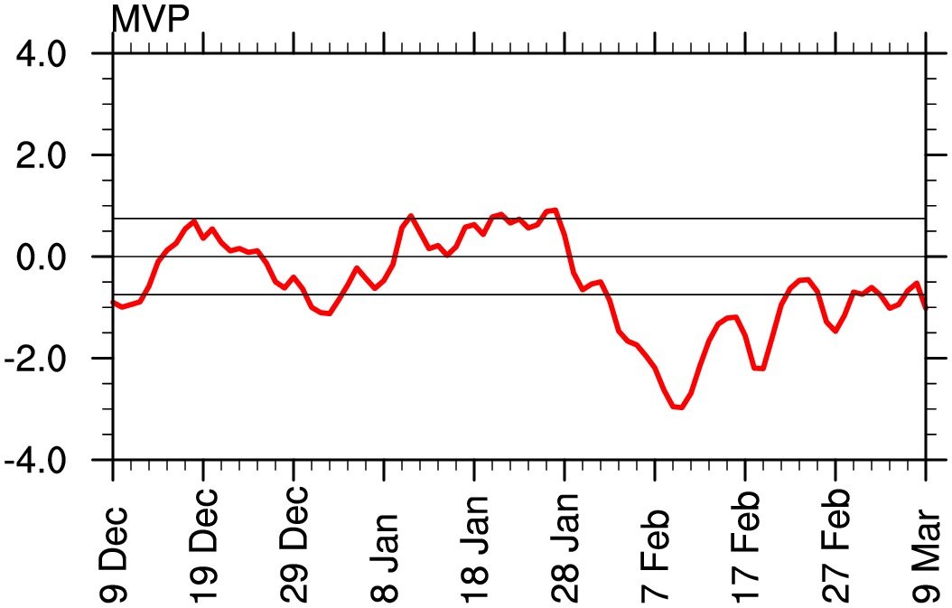
Some of the experimental work to assess the impact of MJO on tangible North American weather is yielding interesting results. For example, typically, Phase 8 of the MJO is typically cold in the east DJF but, when the experimental Multivariate PNA (MVP) is negative, it actually trends warm. MVP is assessing OLR as a decent proxy for tropical convection in the MJO domains as well as streamwaves at 850 and 200 hPA in near real time . If you look at the MVP plot for the last 90 days, you can see it has indeed been negative during the time period we expected the best outcomes according to the ENSO and MJO forecasts.

If y'all want to dig into MVP a bit, here's some decent reading.
Peer-reviewed, evidenced-based paper:
White paper inject for NWS staff:
https://www.nws.noaa.gov/ost/climate/STIP/37CDPW/37cdpw-cschreck.pdf
Easy-to-digest slide deck from the researchers:
https://slideplayer.com/slide/13103907/
Link to real-time Multivariate PNA outputs:
https://ncics.org/portfolio/monitor/mjo/extratropics/
BTW, click around that site if you are interested in tropical forcing outputs. There's an absolute treasure trove of MJO & tropical forcing data there.
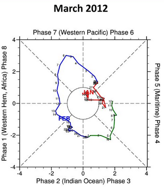
Was interested to note at in the slide deck how the infamous Morch 2012 was preceded by some not-bad looking MJO history. Most of February spent in 8 -1- 2.
-
I am eagerly awaiting a PSU postmortem for this winter. In the meantime, does anybody know if the extreme SSWE produced some good blocking for someone, somewhere? The eastern CONUS obviously did not cash in, but I am hoping somebody did.
-
2 hours ago, C.A.P.E. said:
Given the the extremely favorable winter outlooks
But were those favorable outlooks really realistic though? From discussion I have seen on here, it seems like a lot of warning signs were missed.
No disagreement about the LR models though. I'm not sure I will ever again be able to take them seriously.
-
All right, looks like it's about time to lower the blinds, turn out the lights and wrap this one up.

July 2019 OBS
in Southeastern States
Posted
An interesting tidbit. On July 4th, KFAY tied a record high temp (98 F) and set rain record (2.80") in the same day. That duo has got to be relatively rare occurance.