

cbmclean
-
Posts
2,590 -
Joined
-
Last visited
Content Type
Profiles
Blogs
Forums
American Weather
Media Demo
Store
Gallery
Posts posted by cbmclean
-
-
Who is this "kid from Delaware"?
-
6 minutes ago, psuhoffman said:
Was gonna day I remember that same from a poster on here who was pretty awful. God help them if anyone takes him seriously on Twitter.
Well if he just steals WxUSA's posts at least his Twitter followers will be well informed.
-
 1
1
-
-
3 hours ago, WxUSAF said:
Makes sense whoever you are
They say imitation is the sincerest form of flattery. Consider yourself flattered.
-
1
-
-
4 minutes ago, psuhoffman said:
I’m not concerned but will point out the smoothed our blah look on the ensembles day 10-15 is not because they mostly think that will be the pattern. It’s becagas they have no clue with huge divergence and a mean that combines a lot of variance (some good looks and some bad) into an ambiguous mean. In short that look is not likely and it’s going to end up adjusting one way or the other and depending on which camp is correct we could end up with a pretty good pattern or a real crap one.
Curious why you are not concerned. Someone posted an MJO forecast in the banter firm. Patented entry into crap phases and sloooooooooow down. Has me spooked.
Edit Nevermind. You answered my question before I even posted it.
-
2 minutes ago, WxWatcher007 said:
Am I missing something? I don’t get that read from the main thread. I’ve actually thought the discussion has been pretty level headed. So far.
Well there is a definite downer mood, but the question is whether it is justified or not. I am not knowledgeable enough to know.
-
2 hours ago, psuhoffman said:

Trying to learn to interpret patterns at 500 hp. I see a trough in the east, but heights are simply normal. Mildly AN heights in Greenland, but higher heights to the South. So NAO slightly positive. AO ambiguous but at least not strongly positive. +PNA right?
Overall what is the sensible weather expected in the Eastern CONUS?
-
26 minutes ago, WinterWxLuvr said:
You’re right, I didn’t zoom in. Looks like a box whisker plot. But that would mean it’s not a percentile because that would be more uniform.
Percentiles aren't necessarily symmetric. It all depends on the underlying data. There must be some extreme outliers on both sides.
-
34 minutes ago, Bob Chill said:
Of course I'd much prefer a -ao but the long range doesn't look bad at all anymore. There will likely be a shortlived period of zonal/pac air next week but there's universal agreement on the pna going up and keeping us in a "non-shutout pattern". My gut hunch is the epo will not be hostile either. I'm also not sold on a long duration big nasty +ao setting up shop. A lot of hints being dropped that blocking (of some kind) will be close by.
We all want a perfect pattern 24/7 but that's no how it works. Ultimately we just need to spend as much time as possible in a non-shutout pattern and just let simple odds take over. Our area typically needs 4 legit chances per event that actually delivers. Keep the non shutout pattern going, the chances coming, and we'll score. There's nothing worse than a 4-6+ week shutout pattern setting up during met winter. I'm not seeing that threat at all right now and that's a good reason to have a happy weenie
I just have nightmares of a pig Pacific vortex or a 594 dm death ridge in the Atlantic a la Dec 2015. They haunt me.
-
1 minute ago, WxUSAF said:
No, it’s either the 50th or 75th percentile or the first standard deviation.
On a standard boxplot it would be the 25th to 75th percentile, so that would be my first guess.
-
3 minutes ago, WinterWxLuvr said:
Probably the op
Anyway consider me bummed. It is clear the overall message is +AO/+EPO. I had my hopes set on the EPO.
-
4 hours ago, poolz1 said:
Looks like we may need to get through a few days to get any king of handle on what the LR will look like. A lot of spread on the EPS....
AO

Check of the spread on the EPO...Could be +4 or could be -6....


What does the thicker bar in the interior of the overall error bars mean?
-
12 hours ago, ravensrule said:
Just got back from LA. What a game, what a friggin butt whupping. I honestly never dreamed they could play this well. I was surprised at how many Ravens fans were there. I would say at least 5,000. Nice showing. I think if we beat SF this Sunday we run the table and get the number 1 seed.
Be careful, though. Being this hot in the NFL is like having one of those invincible stars in Super Mario. You are invincible for a while. But then it wears off.
Of course I am a Dolphins fan so maybe I am just bitter.
-
1
-
-
36 minutes ago, psuhoffman said:
I think 99% of us here know not to take ANYTHING in the long range too seriously. But that said, it's still better to see good runs than bad ones. And looking at general pattern trends is not the same as looking at a specific synoptic event at day 15. So I think we should be able to post when something looks good in a general pattern sense and log it into "this is good" evidence without having to always have the disclaimer that we shouldn't take it literally. I would rather just ignore the random posts we get every so often by some clown telling us not to look at long range guidance.
I find it confusing why such people hang out in a LR thread.
-
 1
1
-
-
28 minutes ago, psuhoffman said:
I am pretty sure we are going to "warm up" by around Dec 7th-10th as we briefly lose the pacific and the TPV is moving across the pole creating a brief but extremely positive AO. What I am looking at is whether we can flip back cold again sometimes mid December in time for the holidays.
I have a very bitter memory of one point last year when the mid-December warm-up was looking like it was going to be very brief. Cut to 11 pm New Years Eve and it was 67 F outside my parent's house. A nearly perfect storm track went over you guys a few days later and produced only rain. I think it made Bob Chill physically sick. Hopefully we don;t get a repeat this year.
-
1 minute ago, C.A.P.E. said:
Hopefully the CFS is as crappy a model as we all believe it to be, lol.
Maybe we can hope that all of the seasonals are as painfully wrong this year as they were last year about the beautiful fantasy pattern that always happened just past week 3.
-
1
-
-
1 hour ago, nj2va said:
If the AO is forecasted to be so abnormally +, question for the pros...why do we have this map? Slightly +PNA driving that?

That is truly fascination, how in the world could that 2m anomaly map coincide with that H5 look, unless the GEFS ensemble mean is way different than the OP?
-
3 hours ago, C.A.P.E. said:
Shhh. My trolling is very subtle.

I wait until some one pulls out the recurving typhoon before I cliff jump./
-
8 minutes ago, Ralph Wiggum said:
We have heart breaks of our own with these up here. You say Philly can do ok....up here we say the same that we usually fail but NYC usually does good. And in NYC they say BOS. So, yeah funny how that works. NAO block ftw! C'mon lets do this even if it goes to sh!t afterwards. Need a DC-BOS special to break the ice early.
And in the SE, we say the whole MA is a land of milk, honey, and snow.
-
4
-
-
Just now, psuhoffman said:
So you’ve met DT...
That makes me chuckle.
-
1
-
-
Just now, pasnownut said:
NAO/EPO/AO....whatever it takes to get us snow. Gotta say that the 6z GEFS surely depicts the EPO on roids. Cross polar flow is a term that might need dusted off if that comes to light.
Shouldn't have too much dust on it. Didn't we just have a nice cross-polar episode a few weeks a when we had our big cold shot?
-
3
-
-
32 minutes ago, Bob Chill said:
Check out the h5 loops on the 18z gfs & gefs and stare at Greenland. Starts in 4 days and never lets up through the end of the run
I will accept the existence of a -NAO when it happened a week ago.
Actually, scratch that, -NAOs can exist in March - November, just not in Dec - Feb.
-
5 minutes ago, Ralph Wiggum said:
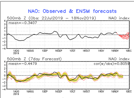
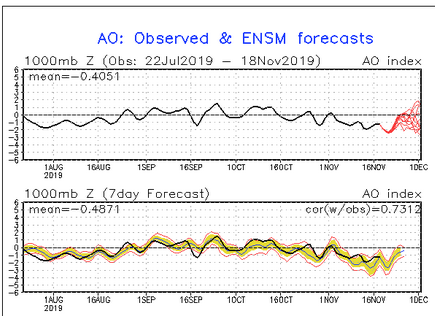
Is it correct that the AO and NAO phases are actually based on surface pressures more than 500mb/geopotential heights?
For what it is worth on the cpc page giving the NAO/AO conditions, the label says 500 mb for the NAO but 1000 mb for the AO.
 .
.
-
2
-
-
10 minutes ago, Bob Chill said:
Yep. Looks like a typical -PNA period where the western ski areas get dumped on for a couple weeks. Not warm here but still far from a good snow pattern here. However, the PNA typically oscillates so even if the EPS is right it's not unreasonable to expect the PNA to flip back + after the storm cycle. These types of patterns commonly hold for 1-2 weeks. We're still a month away from our climo not fighting us with every little detail. I'm good with everything as is and can easily envision how it could improve at a time when our area stands a chance at a snow event.
Still trying to sort out my Pacific teleconnections. So a -PNA pattern can come and go relatively quickly, but a dreaded +EPO will embed itself for weeks?
-
29 minutes ago, psuhoffman said:
I won’t name names because there is nothing wrong with this, but some of the seasonal forecasters with the higher scores tend to go chalk and predict what climo says is likely most of the time. Fact is our current climo says we have a below avg snow winter 65-70% of the time. Take non nino years (yea mod nino is the winner but even weak and strong ones up the chances of a + climo year some) and the chances are like 90% we go below climo. In the last 25 non nino winters going back to 1984...only 2 have been +climo. 1996 and 2014.
So basically if you predicted above avg snow every nino and below to avg every other winter you will have had a 84% verification score in the last 37 years. I could do that. Anyone could do that. But 1996 and 2014 did happen. And climo runs in cycles and you never know when it will shift. So just going climo every year you will miss the anomalies. It’s also no fun and I am in this for run. If my job depended on it I probably would go climo and pimp my great success rate.
This sounds like textbook advertisement for setting one's expectations based on the median instead of the mean.
-
1
-


November Banter 2019
in Mid Atlantic
Posted
OK, this forum took a dramatic turn.