
cbmclean
-
Posts
3,279 -
Joined
-
Last visited
Content Type
Profiles
Blogs
Forums
American Weather
Media Demo
Store
Gallery
Posts posted by cbmclean
-
-
0.17". At least enough to lay the pollen for a bit.
-
Didn't think I was going to need long pants anymore until the fall, but here we are. Currently 56.1 F, which is also the daily low (so far). Blustery as well.
-
0.18".
-
28.6 for a low last night. Last hard freeze of the season?
-
-
11 hours ago, Stormchaserchuck1 said:
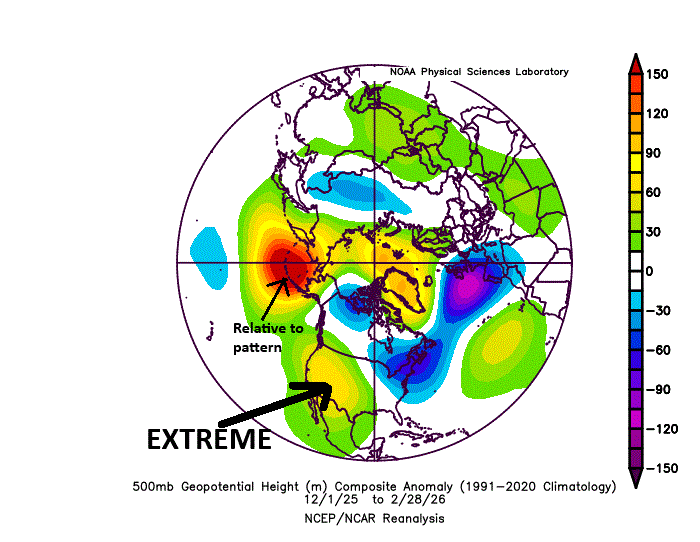
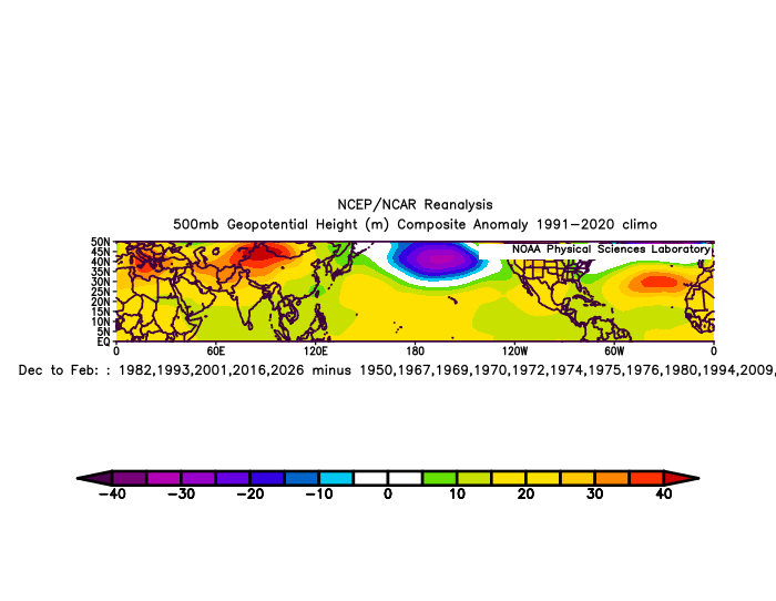
Sorry to dwell on the Winter West Coast ridge again, but this really stands out to me as an extreme anomaly
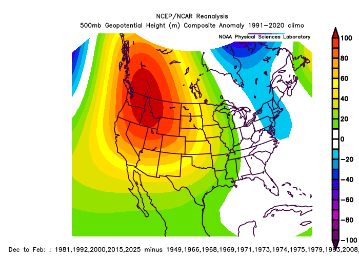
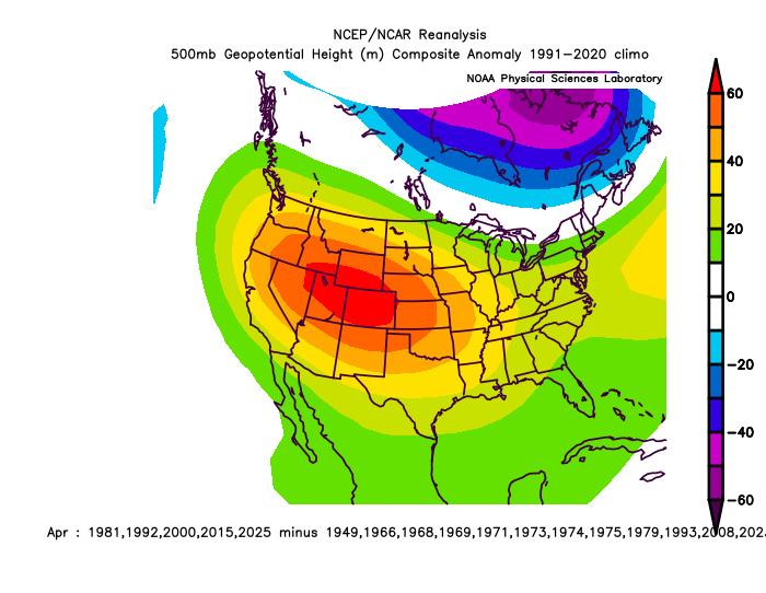
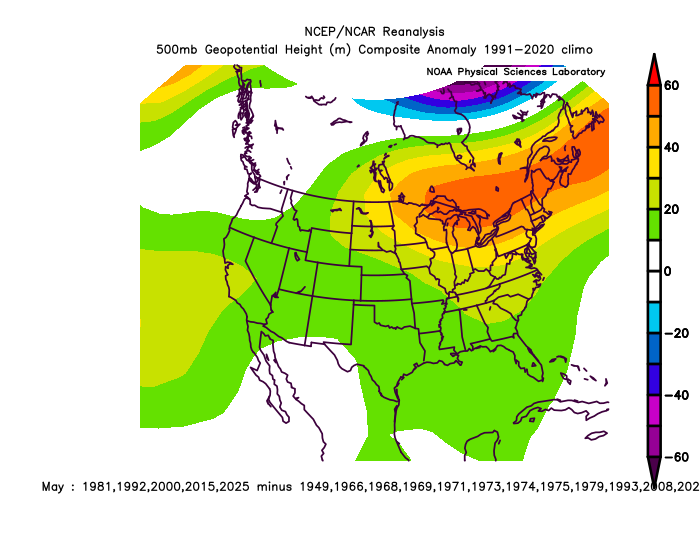
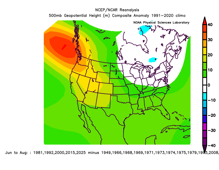
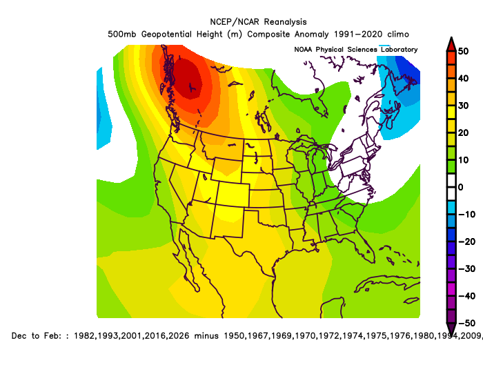
Most extreme West Coast DJF ridge analogs
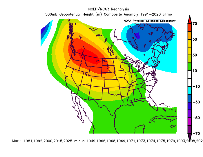
The news is, the ridge really sticks around +time in analog cases.. this is the following year:
March (not included in my visual analog picks.. yet almost as strong of an anomaly!)
April (+60dm over the SW, US is extreme!)
May
Summer (June-August)
Following Winter (26-27 analog)
^75% of the N. Hemisphere is +H5 in the following Winter, which fits a warming sequence possibly associated with El Nino. The main point is just the skew warm-general +time.
This is the mid-latitudes the following Winter (26-27 analog)
Winter PNA DJF 25-26 was negative, so interesting that they got a #1 record warm Winter on the West coast. Monthly PNA:
-1.41
2026   0.79  -0.56
How is it possible for there to be a -PNA with that much of a western ridge? What exactly is the definition of the PNA index?
-
3 hours ago, GaWx said:
Even if RONI ends up peaking +1.5+, the DC area could still have a BN averaged winter based on the 2009-10, 1965-6, and 1957-8 analogs. What did these 3 analogs have in common? -NAO and -AO, both of which were lacking in nearly all of the other +1.5+ ENSO winters. It wasn’t the Pacific that made the difference as they almost always had +PNA and no -EPO/-WPO for all +1.5+ ENSO.
So, a -NAO/-AO would appear to be the deciders. The major challenge though for getting a -NAO is going to be sunspots almost for sure still not getting down to low (say, sub 35/month). There hasn’t been even one -NAO winter since 1980 with a >35 sunspot avg! So, the odds would be heavily against a cold DC area winter should ENSO get to +1.5+. In that case, the best hope would be for a NN instead of mild DC winter. Your better hope for a cold winter would as you’d suspect be for a sub +1.5 RONI peak this fall/winter.
What is the hypothesized physical mechanism of causation between sunspots (or solar cycle in general) and high latitude blocking?
-
10 minutes ago, wxman said:
You would think that this is the exact type of thing the the AI models would address? At least where I am the euro AI never really loved the blizzard and while I'm happy with my 16.3" it was not the 2 feet shown on many non-AI models. In some respects outside the immediate coast up through NYC-BOS the euro AI was closer to reality.
I had a similar thought about cold chasing moisture, especially east of the Apps and double especially east of the taller Apps down in my neck of the woods. Every model run in history overestimates how fast the cold gets over the mountains and frequently hallucinates phantom snow as a result. Since the AIs are trained on historical data one would think that this bias should go poof on an AI model.
-
 1
1
-
-
56 minutes ago, psuhoffman said:
Not sure this is the right thread but... something to keep in mind for future miller b storms, almost every single one going back to the 80s, tends to trend west up until about 24-36 hours out, and then shifts east and pulls the rug out at the last minute to some extent. Some didn't do it to us...like Jan 2015 which did that rug pull to NYC, or Feb 89 that rug pulled me in NJ, but they all do it. Some recent examples for our area are Dec 2000, Boxing day, March 8, 2018, Feb 1 2021, and this week. Where around 24-48 hours out things were trending west and we got excited and then at the very end reality set in and the storm ended up just a little northeast. That is the MO. That happens ALWAYS every single time. Expect it. It just is how the models are with these miller b storms. I don't know why. I have just observed they tend to be under amplified and too far east around days 4-7 then over correct and get us excited around day 2-3 and then shift back at the last minute and everything shifts 50-75 miles east the final 24 hours.
That doesn't mean we can't EVERY get a lot of snow from a miller B, but it's super rare and we want it amplifying well west not relying on getting the very back edge of the developing CCB zone because that will almost always end up further east than guidance shows 2-3 days out.
I have seen some debate if this was a Miller A or B or hybrid or what (which is not unusual). I'm beginning to wonder if how useful those categories really are, but I was under the impression that one of the hallmarks of a B was a Ohio Valley low that transfers, and I didn't think that there was one of those in this case. In your perception, what made this storm more "B-ish"?
-
1 minute ago, Terpeast said:
Yeah. If the PDO doesn’t take its annual nosedive this summer, we may have a shot at more +pna now that coastal storm tracks seem to be coming back, and we may also get more blocking up top. Couple that with storms (both tropical and midlatitude) getting more intense with more moisture than in the past, we may have an above normal shot at a MECS if the nino doesn’t go ape. I don’t think it will because the WWBs have been struggling and the SOI is still positive, and subsurface is only mildly AN. If this was gonna be a super, we’d already be seeing +6 subsurface with a negative SOI by now.
Webb seems to be really hyping the strength. I suspect he would be gleeful with a strong east-based episode.
-
1 minute ago, fujiwara79 said:
so we currently have a -PNA and +NAO, and yet we have a 970mb low crawling up the coast with blizzard warnings in NYC. When was the last time something like that happened?
Isn't there going to be a western ridge spike, aka +PNA?
-
 1
1
-
-
4 minutes ago, bncho said:
he surface deception
Dang Euro with its surface deceptions...

-
 1
1
-
-
This SE weenie is rooting for you guys!!
-
 2
2
-
-
OK, honest thermodynamics/atmospheric physics questions that has puzzled me for a long time. Right now my temp is 60.3 °. Temps are dropping very slowly. Sometimes on nights like tonight's the temps completely steady out. The ground is warm so it radiates energy at a high rate. To slow (or even stop) the temperature decrease, something must be adding energy, but what is it? The sky is clear so there is no downwelling radiation from clouds. There is no wind so there is no warm-air advection or turbulent mixing. Where is the energy coming from? Is it radiating from the water vapor in the air?
-
Down to 23 F this morning. Really impressed with the cold hanging on as much as it can.
-
I propose consideration to replace all normal water in the biosphere with heavy water (D2O). Since it freezes at ~38.9 °F we could gain a lot of marginal events. We'd have to maintain a supply of regular water for drinking since in large quantities heavy water is toxic.
-
 1
1
-
 1
1
-
-
Some background on AI models. https://x.com/i/status/2021333729088585882
-
 1
1
-
-
49 minutes ago, psuhoffman said:
Average highs might be too warm but what is the mean 850 and wet bulb temp? Again why do you act like we need a cold regime to snow. We have needed that recently but historically we got so many snowstorms in marginal thermal regimes if we get a good storm track. Do you know how many Baltimore snows were 45 the day before and after it snowed. We need those to return. Because cold regimes are often dry! A big part of our snow climo was from snowstorms in marginal temp regimes not cold ones. One of the reasons we are stuck in the worst snow drought EVER is that for the last 10 years or only snows when it’s cold. We need to get snow when the pattern isn’t perfect or Baltimore is going to continue to average half of what it’s long term 140 year average actually is.
Do you actually think there is a chance to recover any of that loss? I fear that ship may have sailed.
-
This is getting surreal.
-
3 minutes ago, psuhoffman said:
Because we had a god damn perfect epo/pna pattern. Of course it can still get cold if everything is fucking perfect. We’re talking about losing snow along the margins. losing those snows we used to sneak in when the pattern wasn’t good.
Next year will be extremely telling. If a decent central or even west-based El Nino develops, can you guys score with marginal homegrown cold, without crazy EPO blocking? Are we starting an exit out of the dreg -PDO minimum? Can we ever have regular bad pattern that isn't a shit the blinds?
-
 1
1
-
-
10 minutes ago, psuhoffman said:
My kids don’t watch it!
Have you watched some of the past shows? Or some of the stuff on MTV? I probably don’t want them seeing some of that no…but I don’t remember the outrage at this stuff that’s been going on for YEARS. It’s been like 20 years since the wardrobe malfunction and forget the mistake how bout the fact he was mock groping her which caused the malfunction. This is a lost cause and been this way a long time so why the sudden outrage now? I suspect I know why.
We know the true cause is...Leporiphobia.
-
10 minutes ago, Scarlet Pimpernel said:
True! It's still "civilized" at that time of year if you're warmer than normal! I still remember Dec. 2015, we had like a +9 departure for the month, ridiculous warmth (though it didn't feel overly uncomfortable at that time of year)...and I was thinking thank God we didn't get a +9 in July!!!
That Dec 2015 torch scarred me down here in NC. The daytime highs were bad but the ridiculous nighttime "lows" were nauseating. RDU didn't dip below 61 from Dec 23rd through the 28th. Where I was at visiting my parents was even worse. KFAY had back-to-back days of 80/67 on Christmas Eve and Christmas Day. It was humid the whole time too, with plenty of gnats and mosquitoes.
-
For those like me who also enjoy cold for its own sake, this winter is producing. Not truly wall-to-wall because we did have some legit warm periods around Christmas and in early January, but the cold period starting at Thanksgiving that lasted until 12/15 or so was legit. The little cold snap around New Years was nice, and of course the current cold period has been more than legit. I also loved the little appetizer around Veteran's Day.
34.0/2.7.
-
 1
1
-
 1
1
-
-
51 minutes ago, Weather Will said:
The only thing we know about the next system is that No One except the Almighty knows the final outcome yet!!!!
Chuck knows.
-
 3
3
-

April 2026 Obs
in Southeastern States
Posted
0.55 last night. 1.10 for the week.